ATL: DORIAN - Models
Moderator: S2k Moderators
-
SconnieCane
- Category 5

- Posts: 1013
- Joined: Thu Aug 02, 2018 5:29 pm
- Location: Madison, WI
Re: ATL: DORIAN - Models
1 likes
-
SEASON_CANCELED

- Category 3

- Posts: 887
- Joined: Mon Jul 06, 2009 5:17 am
- Location: 8 Bit Charlie Sheen
Re: ATL: DORIAN - Models
Hwrf always bombs the system
1 likes
i am a big stupid ugly moron with an ugly face and a big butt and my butt stinks and i like to kiss my own butt
-
SEASON_CANCELED
- Category 3
- Posts: 887
- Joined: Mon Jul 06, 2009 5:17 am
- Location: 8 Bit Charlie Sheen
Re: ATL: DORIAN - Models
Keeping a clear eye on Euro.
If that trat holds we get some nasty effects on the west coast and inland
Tampa and Sarasota need to keep a clear eye
If that trat holds we get some nasty effects on the west coast and inland
Tampa and Sarasota need to keep a clear eye
3 likes
i am a big stupid ugly moron with an ugly face and a big butt and my butt stinks and i like to kiss my own butt
-
Bocadude85

- Category 5
- Posts: 2991
- Age: 39
- Joined: Mon Apr 18, 2005 2:20 pm
- Location: Honolulu,Hi
Re: ATL: DORIAN - Models
Models really loving the Melbourne/Cape area, could we be seeing history in the making with a major hurricane landfall in Brevard County, I guess only time will tell.
0 likes
-
gatorcane

- S2K Supporter

- Posts: 23708
- Age: 48
- Joined: Sun Mar 13, 2005 3:54 pm
- Location: Boca Raton, FL
Re: ATL: DORIAN - Models
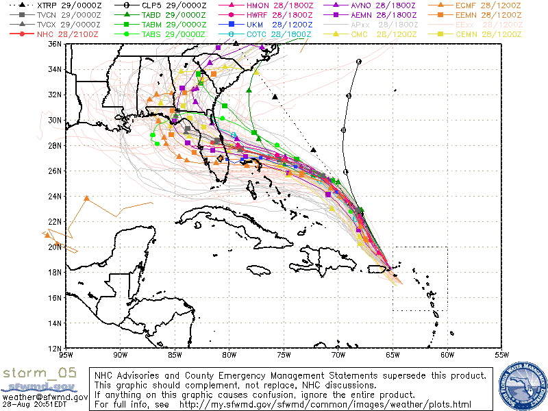
Bumping this. You can clearly see from the 12Z Euro ensembles that the members that show a more intense hurricane turn more due west into South Florida or even the FL Straits with the members that are less intense head more WNW. The thing that makes me think the South Florida members may be correct is that I don’t recall a CAT 4 or 5 hitting the Florida east coast north of Stuart looking back in history. Can anybody verify?

Last edited by gatorcane on Wed Aug 28, 2019 8:23 pm, edited 1 time in total.
2 likes
-
AxaltaRacing24
- Category 5
- Posts: 1774
- Age: 25
- Joined: Wed Jul 27, 2016 11:14 am
- Location: Jupiter, FL
Re: ATL: DORIAN - Models
gatorcane wrote:
Bumping this. You can clearly see from the 12Z Euro ensembles that the members that show a more intense hurricane turn more due west into South Florida with the members that are less intense head more WNW. The thing that makes me think the South Florida members may be correct is that I don’t recall a CAT 4 or 5 hitting the Florida east coast north of Stuart looking back in history:
https://i.imgur.com/qzBMHXi.png
Plus the Euro and UK are sticking to this run after run after run. IF this continues well into tomorrow, it would be hard to ignore.
1 likes
-
Bocadude85
- Category 5
- Posts: 2991
- Age: 39
- Joined: Mon Apr 18, 2005 2:20 pm
- Location: Honolulu,Hi
Re: ATL: DORIAN - Models
gatorcane wrote:
Bumping this. You can clearly see from the 12Z Euro ensembles that the members that show a more intense hurricane turn more due west into South Florida or even the FL Straits with the members that are less intense head more WNW. The thing that makes me think the South Florida members may be correct is that I don’t recall a CAT 4 or 5 hitting the Florida east coast north of Stuart looking back in history. Can anybody verify?
https://i.imgur.com/qzBMHXi.png
No major hurricane has ever made landfall north of Martin County as far as records go. Dora of 1964 is as close as one came.
Last edited by Bocadude85 on Wed Aug 28, 2019 8:34 pm, edited 1 time in total.
1 likes
-
DESTRUCTION5

- Category 5
- Posts: 4430
- Age: 44
- Joined: Wed Sep 03, 2003 11:25 am
- Location: Stuart, FL
Re: ATL: DORIAN - Models
Bocadude85 wrote:gatorcane wrote:
Bumping this. You can clearly see from the 12Z Euro ensembles that the members that show a more intense hurricane turn more due west into South Florida or even the FL Straits with the members that are less intense head more WNW. The thing that makes me think the South Florida members may be correct is that I don’t recall a CAT 4 or 5 hitting the Florida east coast north of Stuart looking back in history. Can anybody verify?
https://i.imgur.com/qzBMHXi.png
No major hurricane has ever made landfall north of Indian River County as far as records go. Dora of 1964 is as close as one came.
North of Martin
0 likes
GATOR NATION IS E V E R Y W H E R E !

Re: ATL: DORIAN - Models
gatorcane wrote:The thing that makes me think the South Florida members may be correct is that I don’t recall a CAT 4 or 5 hitting the Florida east coast north of Stuart looking back in history. Can anybody verify?
http://www.twitter.com/philklotzbach/st ... 0274168834
0 likes
Storm Track: Erin '95, Opal '95, Danny '97, Georges '98, Ivan '04, Dennis '05
-
Bocadude85
- Category 5
- Posts: 2991
- Age: 39
- Joined: Mon Apr 18, 2005 2:20 pm
- Location: Honolulu,Hi
Re: ATL: DORIAN - Models
DESTRUCTION5 wrote:Bocadude85 wrote:gatorcane wrote:
Bumping this. You can clearly see from the 12Z Euro ensembles that the members that show a more intense hurricane turn more due west into South Florida or even the FL Straits with the members that are less intense head more WNW. The thing that makes me think the South Florida members may be correct is that I don’t recall a CAT 4 or 5 hitting the Florida east coast north of Stuart looking back in history. Can anybody verify?
https://i.imgur.com/qzBMHXi.png
No major hurricane has ever made landfall north of Indian River County as far as records go. Dora of 1964 is as close as one came.
North of Martin
Correct, I don’t know why I typed Indian River
0 likes
-
GeneratorPower

- S2K Supporter
- Posts: 1648
- Age: 46
- Joined: Sun Dec 18, 2005 11:48 pm
- Location: Huntsville, AL
Re: ATL: DORIAN - Models
AxaltaRacing24 wrote:gatorcane wrote:
Bumping this. You can clearly see from the 12Z Euro ensembles that the members that show a more intense hurricane turn more due west into South Florida with the members that are less intense head more WNW. The thing that makes me think the South Florida members may be correct is that I don’t recall a CAT 4 or 5 hitting the Florida east coast north of Stuart looking back in history:
https://i.imgur.com/qzBMHXi.png
Plus the Euro and UK are sticking to this run after run after run. IF this continues well into tomorrow, it would be hard to ignore.
Look at what those ensembles are telling you! Stronger storms are turning further south!! Weak storms going north. Exactly as expected for a ridge above a storm!
1 likes
-
Blown Away

- S2K Supporter
- Posts: 10253
- Joined: Wed May 26, 2004 6:17 am
Re: ATL: DORIAN - Models
Am I reading the Euro Ensembles map Gator posted correctly showing Dorian as a TS all the up to the left turn?
0 likes
Hurricane Eye Experience: David 79, Irene 99, Frances 04, Jeanne 04, Wilma 05… Hurricane Brush Experience: Andrew 92, Erin 95, Floyd 99, Matthew 16, Irma 17, Ian 22, Nicole 22…
-
toad strangler

- S2K Supporter
- Posts: 4546
- Joined: Sun Jul 28, 2013 3:09 pm
- Location: Earth
- Contact:
Re: ATL: DORIAN - Models
Hmmmm.... potential stall. Product of that are some N moving floaters
https://twitter.com/ryanmaue/status/1166885764170440707
https://twitter.com/ryanmaue/status/1166885764170440707
Last edited by toad strangler on Wed Aug 28, 2019 8:45 pm, edited 1 time in total.
0 likes
My Weather Station
https://www.wunderground.com/dashboard/pws/KFLPORTS603
https://www.wunderground.com/dashboard/pws/KFLPORTS603
-
otowntiger
- Category 5
- Posts: 1932
- Joined: Tue Aug 31, 2004 7:06 pm
Re: ATL: DORIAN - Models
Bocadude85 wrote:
Models really loving the Melbourne/Cape area, could we be seeing history in the making with a major hurricane landfall in Brevard County, I guess only time will tell.
It does seem that a number of models have been wanting to send Dorian to visit us here in Orlando. If this storm comes in hot at that angle say around Melbourne that is the worst case scenario for Metro Orlando. Could get winds in excess of 100mph. Would be worse than Charley in ‘04 which was a pretty good blow.
1 likes
Re: ATL: DORIAN - Models
gatorcane wrote:
Bumping this. You can clearly see from the 12Z Euro ensembles that the members that show a more intense hurricane turn more due west into South Florida or even the FL Straits with the members that are less intense head more WNW. The thing that makes me think the South Florida members may be correct is that I don’t recall a CAT 4 or 5 hitting the Florida east coast north of Stuart looking back in history. Can anybody verify?
https://i.imgur.com/qzBMHXi.png
You're assuming it will be a cat. 4 or 5 and you cant make that assumption
2 likes
Re: ATL: DORIAN - Models
toad strangler wrote:Hmmmm.... potential stall. Product of that are some N moving floaters
https://twitter.com/ryanmaue/status/1166885764170440707
What's the impact of a stall on intensity?
0 likes
-
Tyler Penland
- Tropical Depression

- Posts: 63
- Joined: Fri Aug 19, 2011 12:32 pm
- Location: Blowing Rock, NC
Re: RE: Re: ATL: DORIAN - Models
Generally gradual weakening due to upwelling of cooler water.Ken711 wrote:toad strangler wrote:Hmmmm.... potential stall. Product of that are some N moving floaters
https://twitter.com/ryanmaue/status/1166885764170440707
What's the impact of a stall on intensity?
Sent from my SM-G960U using Tapatalk
0 likes
****The above is NOT AN OFFICIAL FORECAST. I am in no way affiliated with the NWS or storm2k, and most likely don't share their opinion. Please refer to NWS/NHC products for official advisories/warnings/forecasts.****
But if you insist, trust me, I'm a physicist.
But if you insist, trust me, I'm a physicist.
-
DESTRUCTION5
- Category 5
- Posts: 4430
- Age: 44
- Joined: Wed Sep 03, 2003 11:25 am
- Location: Stuart, FL
Re: ATL: DORIAN - Models
caneman wrote:gatorcane wrote:
Bumping this. You can clearly see from the 12Z Euro ensembles that the members that show a more intense hurricane turn more due west into South Florida or even the FL Straits with the members that are less intense head more WNW. The thing that makes me think the South Florida members may be correct is that I don’t recall a CAT 4 or 5 hitting the Florida east coast north of Stuart looking back in history. Can anybody verify?
https://i.imgur.com/qzBMHXi.png
You're assuming it will be a cat. 4 or 5 and you cant make that assumption
It's cat 3 and that's what NHC is predicting. Less than cat 3 all bets off. Lots have hit north of Martin cat 2 or less.
1 likes
GATOR NATION IS E V E R Y W H E R E !

Re: ATL: DORIAN - Models
gatorcane wrote:
Bumping this. You can clearly see from the 12Z Euro ensembles that the members that show a more intense hurricane turn more due west into South Florida or even the FL Straits with the members that are less intense head more WNW. The thing that makes me think the South Florida members may be correct is that I don’t recall a CAT 4 or 5 hitting the Florida east coast north of Stuart looking back in history. Can anybody verify?
https://i.imgur.com/qzBMHXi.png
In 1880 a storm hit what is now Cocoa Beach, just south of Cape Canaveral. The records give it 105mph winds but obviously that is just an educated guess.
0 likes
Who is online
Users browsing this forum: No registered users and 33 guests