Tropical Weather Outlook
NWS National Hurricane Center Miami FL
100 AM EST Tue Nov 19 2019
For the North Atlantic...Caribbean Sea and the Gulf of Mexico:
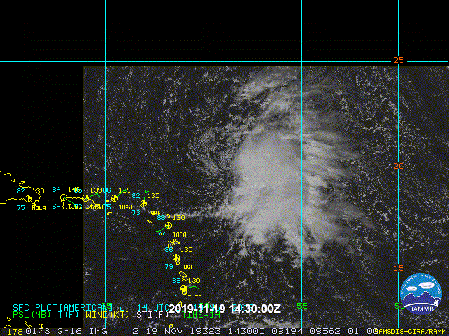
Showers and thunderstorms associated with a broad area of low
pressure centered a little more than 200 miles east-northeast of the
northern Leeward Islands continue to show signs of organization.
Although the surface circulation of the disturbance appears to be
gradually consolidating, recent satellite-derived wind data indicate
that it does not yet have a well-defined center. Additional
development is expected and a tropical or subtropical depression is
likely to form while the system moves northwestward and then
northward over the open Atlantic during the next day or two. The low
is forecast to interact with a frontal system by midweek and further
development is unlikely after that time. For more information, see
High Seas Forecasts issued by the National Weather Service.
* Formation chance through 48 hours...high...70 percent.
* Formation chance through 5 days...high...70 percent.
&&
High Seas Forecasts issued by the National Weather Service can be
found under AWIPS header NFDHSFAT1, WMO header FZNT01 KWBC, and
online at ocean.weather.gov/shtml/NFDHSFAT1.php
$$
Forecaster Zelinsky
ATL: SEBASTIEN - Post-Tropical
Moderator: S2k Moderators
-
Sciencerocks
- Category 5

- Posts: 10181
- Age: 40
- Joined: Thu Jul 06, 2017 1:51 am
Re: ATL: INVEST 90L - Discussion
0 likes
-
cycloneye

- Admin

- Posts: 149275
- Age: 69
- Joined: Thu Oct 10, 2002 10:54 am
- Location: San Juan, Puerto Rico
Re: ATL: INVEST 90L - Discussion
Tropical Weather Outlook
NWS National Hurricane Center Miami FL
700 AM EST Tue Nov 19 2019
For the North Atlantic...Caribbean Sea and the Gulf of Mexico:
1. A broad area of low pressure located about 250 miles northeast of
the northern Leeward Islands is gradually becoming better organized
and the associated shower and thunderstorm activity has been
developing closer to the center since yesterday. If this trend
continues, then a tropical or subtropical depression or storm could
form in the next day or so while the system moves northwestward and
then northward over the open Atlantic. The low is forecast to
interact with a frontal system by midweek and further development is
unlikely after that time. For more information, see High Seas
Forecasts issued by the National Weather Service.
* Formation chance through 48 hours...high...80 percent.
* Formation chance through 5 days...high...80 percent.
High Seas Forecasts issued by the National Weather Service can be
found under AWIPS header NFDHSFAT1, WMO header FZNT01 KWBC, and
online at ocean.weather.gov/shtml/NFDHSFAT1.php
Forecaster Latto
0 likes
Visit the Caribbean-Central America Weather Thread where you can find at first post web cams,radars
and observations from Caribbean basin members Click Here
and observations from Caribbean basin members Click Here
-
MarioProtVI
- Category 5
- Posts: 1034
- Age: 24
- Joined: Sun Sep 29, 2019 7:33 pm
- Location: New Jersey
Re: ATL: INVEST 90L - Discussion
Looks like I might’ve checked out early - 90L well on its way to being classified. Would argue based on ASCAT and satellite data that it’s been a TD since at least 06z. I believe it’ll get classified within the next hour with a projected peak of 60-70 mph given models seem to be trending towards strong TS/weak C1.

1 likes

Re: ATL: INVEST 90L - Discussion
That looks like a closed circulation to me.
0 likes
Irene '11 Sandy '12 Hermine '16 5/15/2018 Derecho Fay '20 Isaias '20 Elsa '21 Henri '21 Ida '21
I am only a meteorology enthusiast who knows a decent amount about tropical cyclones. Look to the professional mets, the NHC, or your local weather office for the best information.
I am only a meteorology enthusiast who knows a decent amount about tropical cyclones. Look to the professional mets, the NHC, or your local weather office for the best information.
-
EquusStorm
- Category 5
- Posts: 1649
- Age: 35
- Joined: Thu Nov 07, 2013 1:04 pm
- Location: Jasper, AL
- Contact:
Re: ATL: INVEST 90L - Discussion
Honestly looks like a closed LLC to me, it was kind enough to pop its head out for a bit to be easily seen. Here's hoping convection syncs up again; hoping for as intense as possible in the short window it's got since it probably won't affect anyone.
2 likes
Colors of lost purpose on the canvas of irrelevance
Not a meteorologist, in fact more of an idiot than anything. You should probably check with the NHC or a local NWS office for official information.
Not a meteorologist, in fact more of an idiot than anything. You should probably check with the NHC or a local NWS office for official information.
-
Socalhurcnegirl227
- Category 1

- Posts: 267
- Age: 37
- Joined: Mon Jun 06, 2016 6:39 pm
- Location: Santa Barbara, CA
Re: ATL: INVEST 90L - Discussion
EquusStorm wrote:Honestly looks like a closed LLC to me, it was kind enough to pop its head out for a bit to be easily seen. Here's hoping convection syncs up again; hoping for as intense as possible in the short window it's got since it probably won't affect anyone.
Dont be too sure, bermuda could be affected by this one
0 likes
"I'm a wandress, i'm a one night stand,
dont belong to no city, dont belong to no man
i'm the violence in the pouring rain,
I'm a hurricane"
dont belong to no city, dont belong to no man
i'm the violence in the pouring rain,
I'm a hurricane"
-
tolakram
- Admin
- Posts: 20178
- Age: 62
- Joined: Sun Aug 27, 2006 8:23 pm
- Location: Florence, KY (name is Mark)
Re: ATL: SEBASTIEN - Tropical Storm
...TROPICAL STORM SEBASTIEN FORMS... ...EXPECTED TO REMAIN OVER OPEN WATERS...
000
WTNT45 KNHC 191501
TCDAT5
Tropical Storm Sebastien Discussion Number 1
NWS National Hurricane Center Miami FL AL202019
1100 AM AST Tue Nov 19 2019
Satellite imagery indicates that the overall cloud pattern of the
disturbance has improved since yesterday, and that the low has
become well-defined. In addition, a late-arriving ASCAT-B
scatterometer pass showed 35-38 kt winds extending 90 n mi from the
center in the northeastern quadrant. This pass also revealed that
the low was nearly closed at the surface, and since the
scatterometer may not have resolved the small scale of the low-level
center it is likely that the surface low is indeed closed. Based on
these data, advisories are being initiated on Tropical Storm
Sebastian with an initial advisory intensity of 40 kt.
The depression will not be in an ideal environment for significant
intensification, as it will be battling dry air to its west and
about 20 kt of northwesterly shear for the next couple of days.
However, due to the presence of an upper trough to the west of the
system, a diffluent environment aloft may aid in some slight
strengthening over the next day or so. After that time, the
depression will begin to interact with an approaching cold front,
and some additional intensification may occur due to baroclinic
processes. The cyclone is then expected to become absorbed by the
front in about 48 hours. The various intensity guidance solutions
are in decent agreement, and the official forecast is near the mean
of these forecasts. There are some timing variations among the
models on when the cyclone will become absorbed by the front, and it
is possible that the depression could be absorbed sooner than
indicated.
The initial motion is 330/07 kt. The depression will be steered to
the northwest in the near term around a deep-layer ridge over the
central Atlantic. By Wednesday, the cyclone should turn north, and
then should accelerate northeastward by Wednesday night as the
cyclone gets caught up in the flow between the retreating ridge and
ahead of the approaching cold front. The model guidance is in good
agreement on this scenario, and on the official forecast track the
cyclone will remain over open waters for the duration of its
existence.
FORECAST POSITIONS AND MAX WINDS
INIT 19/1500Z 20.1N 58.7W 40 KT 45 MPH
12H 20/0000Z 21.0N 59.2W 40 KT 45 MPH
24H 20/1200Z 22.2N 60.0W 45 KT 50 MPH
36H 21/0000Z 23.5N 60.0W 45 KT 50 MPH
48H 21/1200Z 25.5N 58.3W 45 KT 50 MPH...POST-TROP/EXTRATROP
72H 22/1200Z...DISSIPATED
$$
Forecaster Latto
0 likes
M a r k
- - - - -
Join us in chat: Storm2K Chatroom Invite. Android and IOS apps also available.
The posts in this forum are NOT official forecasts and should not be used as such. Posts are NOT endorsed by any professional institution or STORM2K.org. For official information and forecasts, please refer to NHC and NWS products.
-
tolakram
- Admin
- Posts: 20178
- Age: 62
- Joined: Sun Aug 27, 2006 8:23 pm
- Location: Florence, KY (name is Mark)
Re: ATL: SEBASTIEN - Tropical Storm

0 likes
M a r k
- - - - -
Join us in chat: Storm2K Chatroom Invite. Android and IOS apps also available.
The posts in this forum are NOT official forecasts and should not be used as such. Posts are NOT endorsed by any professional institution or STORM2K.org. For official information and forecasts, please refer to NHC and NWS products.
- - - - -
Join us in chat: Storm2K Chatroom Invite. Android and IOS apps also available.
The posts in this forum are NOT official forecasts and should not be used as such. Posts are NOT endorsed by any professional institution or STORM2K.org. For official information and forecasts, please refer to NHC and NWS products.
-
northjaxpro

- S2K Supporter

- Posts: 8900
- Joined: Mon Sep 27, 2010 11:21 am
- Location: Jacksonville, FL
Re: ATL: SEBASTIEN - Tropical Storm
Well, it looks like Sebastien has been classified by NHC. It is Impressive we got that November named storm to close out the 2019 North Atlantic Season afterall. A busier than anticipated season, and a historic season which produced Cat 5 monsters Dorian and Lorenzo!!
2 likes
NEVER, EVER SAY NEVER in the tropics and weather in general, and most importantly, with life itself!!
________________________________________________________________________________________
Fay 2008 Beryl 2012 Debby 2012 Colin 2016 Hermine 2016 Julia 2016 Matthew 2016 Irma 2017 Dorian 2019
________________________________________________________________________________________
Fay 2008 Beryl 2012 Debby 2012 Colin 2016 Hermine 2016 Julia 2016 Matthew 2016 Irma 2017 Dorian 2019
-
TallyTracker
- Category 2

- Posts: 787
- Joined: Thu Oct 11, 2018 2:46 pm
Re: ATL: SEBASTIEN - Tropical Storm
Another surprising thing is that Sebastien has the most tropical origin of any system since Lorenzo! lol 
0 likes
Fran '96, Georges '98, Gordon '00, Gabrielle '01, Charley '04, Frances '04, Jeanne '04, Barry '07, Fay '08, Debby '12, Matthew '16, Emily '17, Irma '17, Michael ‘18, Elsa ‘21, Fred ‘21, Mindy ‘21, Nicole ‘22, Idalia ‘23, Debby ‘24, Helene ‘24

Re: ATL: SEBASTIEN - Tropical Storm
So we have Sebastien, forming in a nearly the same place, and exactly 30 days on the calendar later, than the last Sebastien--and with a similar satellite appearance too.
3 likes
The above post is not official and should not be used as such. It is the opinion of the poster and may or may not be backed by sound meteorological data. It is not endorsed by any professional institution or storm2k.org. For official information, please refer to the NHC and NWS products.
-
EquusStorm
- Category 5
- Posts: 1649
- Age: 35
- Joined: Thu Nov 07, 2013 1:04 pm
- Location: Jasper, AL
- Contact:
Re: ATL: SEBASTIEN - Tropical Storm
Also puts us as being the most active season since 2012. 18 storms does not happen often despite the recent couple decades' antics.
0 likes
Colors of lost purpose on the canvas of irrelevance
Not a meteorologist, in fact more of an idiot than anything. You should probably check with the NHC or a local NWS office for official information.
Not a meteorologist, in fact more of an idiot than anything. You should probably check with the NHC or a local NWS office for official information.
-
Sciencerocks
- Category 5
- Posts: 10181
- Age: 40
- Joined: Thu Jul 06, 2017 1:51 am

-
plasticup
Re: ATL: INVEST 90L - Discussion
Socalhurcnegirl227 wrote:EquusStorm wrote:Honestly looks like a closed LLC to me, it was kind enough to pop its head out for a bit to be easily seen. Here's hoping convection syncs up again; hoping for as intense as possible in the short window it's got since it probably won't affect anyone.
Dont be too sure, bermuda could be affected by this one
Models don't take it close at all
0 likes
-
plasticup
Re: ATL: SEBASTIEN - Tropical Storm
EquusStorm wrote:Also puts us as being the most active season since 2012. 18 storms does not happen often despite the recent couple decades' antics.
Well, minus two since they only recently started naming subtropical storms which inflates the numbers relative to previous years.
1 likes
-
Sciencerocks
- Category 5
- Posts: 10181
- Age: 40
- Joined: Thu Jul 06, 2017 1:51 am
Re: ATL: SEBASTIEN - Tropical Storm
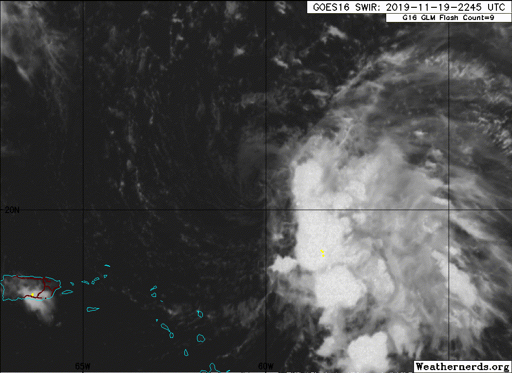
000
WTNT45 KNHC 192035
TCDAT5
Tropical Storm Sebastien Discussion Number 2
NWS National Hurricane Center Miami FL AL202019
500 PM AST Tue Nov 19 2019
The low-level center of Sebastien has been exposed over the past
several hours, as northwesterly shear of 20-30 kt has been pushing
any deep convection off to the southeastern portion of the cyclone.
The initial advisory intensity is being held at 40 kt and is based
on an earlier scatterometer pass that sampled maximum winds of
39 kt.
The initial motion is 305/10 kt. Sebastien is forecast to be steered
to the northwest around a deep-layer ridge over the central Atlantic
through tonight. By Wednesday, the cyclone should turn to the north,
and then accelerate northeastward Wednesday night as the cyclone
gets caught up in the flow between the retreating ridge and ahead of
an approaching cold front. The model guidance remains in good
agreement on this scenario, and the official forecast track keeps
the cyclone over open waters for the duration of its existence.
The shear is not expected to decrease much over the next couple
days while the system remains a tropical cyclone. There may be an
opportunity for some strengthening Wednesday and Wednesday night as
Sebastien turns to the north and northeast and resides under some
favorable upper-level diffluence. By 48 hours, Sebastien is expected
to transition to an extratropical cyclone just ahead of an
approaching cold front. Therefore, additional strengthening
indicated beyond 36 hours should be due to baroclinic processes. The
cyclone should then become absorbed by the cold front by late this
week. The official forecast was adjusted slightly higher from the
previous one at 36 and 48 hours to reflect the anticipated
intensification of the system as it begins its extratropical
transition.
FORECAST POSITIONS AND MAX WINDS
INIT 19/2100Z 20.6N 59.7W 40 KT 45 MPH
12H 20/0600Z 21.3N 60.7W 40 KT 45 MPH
24H 20/1800Z 22.6N 61.9W 45 KT 50 MPH
36H 21/0600Z 24.2N 61.0W 50 KT 60 MPH
48H 21/1800Z 26.0N 58.9W 55 KT 65 MPH...POST-TROP/EXTRATROP
72H 22/1800Z...DISSIPATED
$$
Forecaster Latto
0 likes
-
Sciencerocks
- Category 5
- Posts: 10181
- Age: 40
- Joined: Thu Jul 06, 2017 1:51 am

Re: ATL: SEBASTIEN - Tropical Storm
plasticup wrote:EquusStorm wrote:Also puts us as being the most active season since 2012. 18 storms does not happen often despite the recent couple decades' antics.
Well, minus two since they only recently started naming subtropical storms which inflates the numbers relative to previous years.
NHC started naming subtropical storms in 2002, so doesn’t have a bearing over the past almost 2 decades.
0 likes
Kendall -> SLO -> PBC
Memorable Storms: Katrina (for its Florida landfall...) Wilma Matthew Irma
Memorable Storms: Katrina (for its Florida landfall...) Wilma Matthew Irma
-
EquusStorm
- Category 5
- Posts: 1649
- Age: 35
- Joined: Thu Nov 07, 2013 1:04 pm
- Location: Jasper, AL
- Contact:
Re: ATL: SEBASTIEN - Tropical Storm
Subtropical storm and high latitude brief storm classification seems to have been pretty inconsistent until the last decade or two, been looking through satellite data since 1980 and have found a few candidates that would probably be named today (though I can't find surface data to prove it) I don't think the recent spate of brief STS is new, but classifying them seems to kinda be. Not sure if Andrea/Noel/Olga/Rebekah would've been classified back then.
1 likes
Colors of lost purpose on the canvas of irrelevance
Not a meteorologist, in fact more of an idiot than anything. You should probably check with the NHC or a local NWS office for official information.
Not a meteorologist, in fact more of an idiot than anything. You should probably check with the NHC or a local NWS office for official information.
-
Sciencerocks
- Category 5
- Posts: 10181
- Age: 40
- Joined: Thu Jul 06, 2017 1:51 am
Who is online
Users browsing this forum: No registered users and 234 guests