https://twitter.com/TropicalTidbits/status/1146116713550876673
EPAC: BARBARA - Remnants
Moderator: S2k Moderators
-
cycloneye

- Admin

- Posts: 149719
- Age: 69
- Joined: Thu Oct 10, 2002 10:54 am
- Location: San Juan, Puerto Rico
Re: EPAC: BARBARA - Hurricane
3 likes
Visit the Caribbean-Central America Weather Thread where you can find at first post web cams,radars
and observations from Caribbean basin members Click Here
and observations from Caribbean basin members Click Here
-
Kingarabian

- S2K Supporter

- Posts: 16379
- Joined: Sat Aug 08, 2009 3:06 am
- Location: Honolulu, Hawaii
Re: EPAC: BARBARA - Hurricane
Damn Barbara really looks good. Dont remember the last time I've seen a hurricane with the classic look in the western portion of the EPAC in a long time. I wonder if the abundance of convection giving it this look is due to it being in close proximation of the El Nino standing wave near 135W that the models show.
1 likes
RIP Kobe Bryant


Re: EPAC: BARBARA - Hurricane
Kingarabian wrote:Damn Barbara really looks good. Dont remember the last time I've seen a hurricane with the classic look in the western portion of the EPAC in a long time. I wonder if the abundance of convection giving it this look is due to it being in close proximation of the El Nino standing wave near 135W that the models show.
That and she managed to form at fairly low latitude. Western part of the basin and CPAC as many of us have mentioned is prime breeding ground this year.
She is the only major TC player on Earth right now.
1 likes
The above post and any post by Ntxw is NOT an official forecast and should not be used as such. It is just the opinion of the poster and may or may not be backed by sound meteorological data. It is NOT endorsed by any professional institution including Storm2k. For official information, please refer to NWS products.
Help support Storm2K!


Re: EPAC: BARBARA - Hurricane
I'm impressed by how big this thing is. Look at its size compared to the Gulf of Mexico. It would basically take up the whole thing if it were there. 

5 likes
Igor 2010, Sandy 2012, Fay 2014, Gonzalo 2014, Joaquin 2015, Nicole 2016, Humberto 2019, Imelda 2025
I am only a tropical weather enthusiast. My predictions are not official and may or may not be backed by sound meteorological data. For official information, please refer to the NHC and NWS products.
I am only a tropical weather enthusiast. My predictions are not official and may or may not be backed by sound meteorological data. For official information, please refer to the NHC and NWS products.
-
cycloneye
- Admin
- Posts: 149719
- Age: 69
- Joined: Thu Oct 10, 2002 10:54 am
- Location: San Juan, Puerto Rico
Re: EPAC: BARBARA - Hurricane
18z Best Track only up to 120 kts.I thought they would go a little bit higher.
Location: 12.7°N 122.7°W
Maximum Winds: 120 kt Gusts: N/A
Minimum Central Pressure: 945 mb
Environmental Pressure: 1009 mb
Radius of Circulation: 210 NM
Radius of Maximum Wind: 15 NM
Location: 12.7°N 122.7°W
Maximum Winds: 120 kt Gusts: N/A
Minimum Central Pressure: 945 mb
Environmental Pressure: 1009 mb
Radius of Circulation: 210 NM
Radius of Maximum Wind: 15 NM
0 likes
Visit the Caribbean-Central America Weather Thread where you can find at first post web cams,radars
and observations from Caribbean basin members Click Here
and observations from Caribbean basin members Click Here
-
Kingarabian
- S2K Supporter
- Posts: 16379
- Joined: Sat Aug 08, 2009 3:06 am
- Location: Honolulu, Hawaii
Re: EPAC: BARBARA - Hurricane
cycloneye wrote:18z Best Track only up to 120 kts.I thought they would go a little bit higher.
Location: 12.7°N 122.7°W
Maximum Winds: 120 kt Gusts: N/A
Minimum Central Pressure: 945 mb
Environmental Pressure: 1009 mb
Radius of Circulation: 210 NM
Radius of Maximum Wind: 15 NM
Its because SAB came in with 6.0 again. But ADT has been running near 7.0 and SATCON estimate from 4 hours ago was 130kts.
3 likes
RIP Kobe Bryant
-
Kingarabian
- S2K Supporter
- Posts: 16379
- Joined: Sat Aug 08, 2009 3:06 am
- Location: Honolulu, Hawaii
Re: EPAC: BARBARA - Hurricane
12z Euro has Barbara impacting the southern big Island as a very weak system with some TS winds present.
Only 12 EPS members keep it alive as a weak TS as it reaches the Big Island.
Only 12 EPS members keep it alive as a weak TS as it reaches the Big Island.
1 likes
RIP Kobe Bryant
-
HurricaneRyan
- Category 3

- Posts: 847
- Age: 32
- Joined: Sun Dec 05, 2010 3:05 pm
-
TheAustinMan

- Category 5

- Posts: 1060
- Joined: Mon Jul 08, 2013 4:26 pm
- Location: Central TX / United States
Re: EPAC: BARBARA - Hurricane
Intriguing views of both the ongoing solar eclipse in the Southern Hemisphere and Barbara, providing a dual contrast to the Eastern Pacific this afternoon.
706 kB. Source: SSEC RealEarth

... and a wider shot:
153 kB. Source: SSEC RealEarth

706 kB. Source: SSEC RealEarth
... and a wider shot:
153 kB. Source: SSEC RealEarth
10 likes
Treat my opinions with a grain of salt. For official information see your local weather service.
“It's tough to make predictions, especially about the future.”
“It's tough to make predictions, especially about the future.”
Re: EPAC: BARBARA - Hurricane
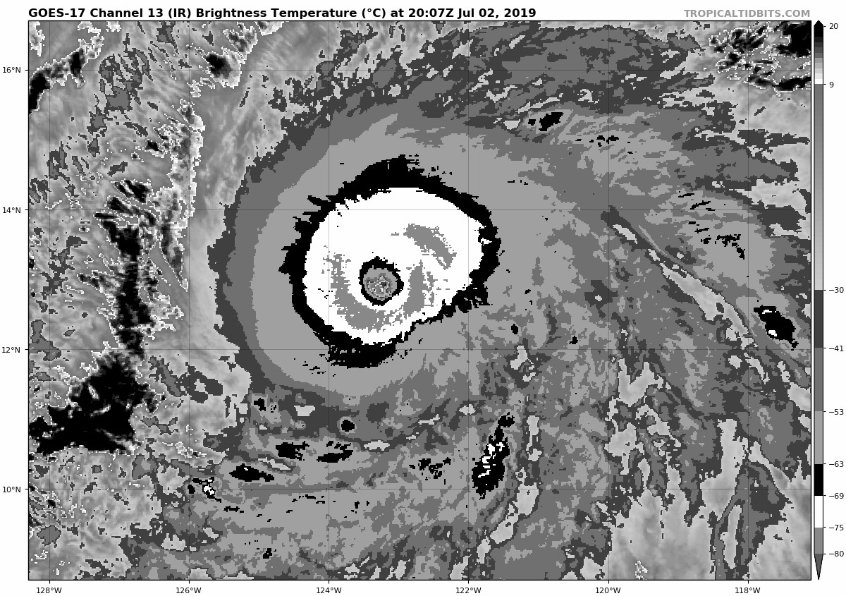
ADT has the eye temp up to +16.8C and the W ring has solidified nicely with some decent CMG in there as well. I don't know that I would be perfectly confident to go 140kts and Cat 5, but I do feel pretty confident in an intensity estimate of 135kts.
0 likes
Solar Aquarian
Lunar Cancerian
 Sagittarian
Lunar Cancerian
-
galaxy401

- Category 5
- Posts: 2446
- Age: 30
- Joined: Sat Aug 25, 2012 9:04 pm
- Location: Casa Grande, Arizona
Re: EPAC: BARBARA - Hurricane
The Solar Eclipse could indirectly cause Barbara to strengthen. After all, it will cause a little Dmax. 
0 likes
Got my eyes on moving right into Hurricane Alley: Florida.

Re: EPAC: BARBARA - Hurricane
Probably stronger than 120 kt, maybe an update statement before next advisory?

Last edited by TorSkk on Tue Jul 02, 2019 3:35 pm, edited 1 time in total.
0 likes
-
cycloneye
- Admin
- Posts: 149719
- Age: 69
- Joined: Thu Oct 10, 2002 10:54 am
- Location: San Juan, Puerto Rico
Re: EPAC: BARBARA - Hurricane
Hurricane Barbara Discussion Number 10
NWS National Hurricane Center Miami FL EP022019
1100 AM HST Tue Jul 02 2019
Barbara is a large and powerful hurricane. The latest ASCAT
scatterometer data confirms that tropical-storm-force winds extend
up to 160 n mi from the center, while the hurricane-force winds
extend up to 30 n mi from the center. A very impressive outflow
channel exists over nearly a 20 degree swath of ocean to the north
of the cyclone. There are at least two mesocyclones evident in the
well-defined eye, and cloud tops are colder than -70 degrees C in
most of the eyewall. A compromise between the subjective satellite
intensity estimates from TAFB and SAB and the objective estimates of
CIMSS ADT and SATCON yield an initial intensity of 120 kt for this
advisory.
Barbara continues to move toward the west-northwest or 290 degrees
at 12 kt, to the south of a mid-level ridge extending from the west
coast of the United States westward across the eastern Pacific.
Barbara will turn northwestward in 36 to 48 hours as it reaches the
southwestern periphery of the ridge. Thereafter, once the cyclone
weakens to a shallow system, it should turn back westward steered by
the low-level flow as per the majority of the track guidance.
There is still a small window of opportunity today and this evening
for additional strengthening of Barbara, while it remains over SSTs
greater than 28 deg C and in a low shear environment. The SSTs ahead
of Barbara start to decline Wednesday morning due to the forecast
track taking the hurricane over progressively cooler waters of about
26.5 deg C in 24 hours, and near 25 deg C in 72 hours. In addition,
the cyclone will be approaching a more stable airmass and moving
into increasing southwesterly vertical shear within a few days. All
of these conditions suggest that Barbara should begin a slow
weakening trend on Wednesday, with the weakening accelerating after
48 hours. By the time Barbara reaches the Central Pacific, it is
likely to be a tropical storm or even a remnant low.
NOTE: Beginning this hurricane season, all National Hurricane
Center eastern Pacific advisory products that utilize local time,
and the corresponding graphical products, will use Hawaiian Standard
Time (HST) instead of Pacific Daylight Time (PDT) or Standard Time
(PST) if the final forecast point is west of 140W. Since Barbara's
day 5 official forecast point is now west of 140W, advisory products
are now being issued in Hawaiian Standard Time.
FORECAST POSITIONS AND MAX WINDS
INIT 02/2100Z 12.9N 123.2W 120 KT 140 MPH
12H 03/0600Z 13.4N 124.9W 130 KT 150 MPH
24H 03/1800Z 14.2N 126.7W 120 KT 140 MPH
36H 04/0600Z 15.2N 128.5W 110 KT 125 MPH
48H 04/1800Z 16.4N 130.3W 95 KT 110 MPH
72H 05/1800Z 18.6N 134.0W 65 KT 75 MPH
96H 06/1800Z 19.3N 139.0W 45 KT 50 MPH
120H 07/1800Z 19.0N 145.0W 30 KT 35 MPH
$$
Forecaster Latto/Cangialosi
0 likes
Visit the Caribbean-Central America Weather Thread where you can find at first post web cams,radars
and observations from Caribbean basin members Click Here
and observations from Caribbean basin members Click Here
-
Yellow Evan

- Professional-Met

- Posts: 16257
- Age: 27
- Joined: Fri Jul 15, 2011 12:48 pm
- Location: Henderson, Nevada/Honolulu, HI
- Contact:
Re: EPAC: BARBARA - Hurricane
----- Current Analysis -----
Date : 02 JUL 2019 Time : 202034 UTC
Lat : 12:54:35 N Lon : 123:20:23 W
CI# /Pressure/ Vmax
6.9 / 925.9mb/137.4kt
Final T# Adj T# Raw T#
6.8 6.9 6.9
Estimated radius of max. wind based on IR : 17 km
Center Temp : +19.1C Cloud Region Temp : -72.2C
Scene Type : EYE
Date : 02 JUL 2019 Time : 202034 UTC
Lat : 12:54:35 N Lon : 123:20:23 W
CI# /Pressure/ Vmax
6.9 / 925.9mb/137.4kt
Final T# Adj T# Raw T#
6.8 6.9 6.9
Estimated radius of max. wind based on IR : 17 km
Center Temp : +19.1C Cloud Region Temp : -72.2C
Scene Type : EYE
0 likes
-
Kingarabian
- S2K Supporter
- Posts: 16379
- Joined: Sat Aug 08, 2009 3:06 am
- Location: Honolulu, Hawaii
-
storm_in_a_teacup

- Category 2

- Posts: 500
- Age: 33
- Joined: Wed Aug 16, 2017 5:01 pm
- Location: Huntsville, Alabama (originally from Houston)
- Contact:
Re: EPAC: BARBARA - Hurricane
cycloneye wrote:https://twitter.com/TropicalTidbits/status/1146116713550876673
Wow that's really cool.
I'm also surprised to find that vortex Rossby wave instabilities are also thought to be a cause of quasi-periodic variability in black hole accretion disks (i.e. what I study.)
Okay, never mind, carry on. There's just so much knowledge in this world and you can only study such a tiny part of it it's very humbling.
4 likes
I know I can't straddle the atmosphere...just a tiny storm in your teacup, girl.
Re: EPAC: BARBARA - Hurricane
Kingarabian wrote:Eye temp up to +20C.
Yep. I believe 1900hurricane has mentioned before on here that he usually finds a difference of 90°C between the eye temp and the CDO temp to be pretty good for Cat 5. If it was someone else who said that or I have that wrong, my apologies in advance.
But, right now with the eye sitting at +20C and the CDO right around -72C, we've got the 90°C differential. I think Barbara might be around 140-145kts, regardless of whether she ever officially gets the Cat 5 classification.
1 likes
Solar Aquarian
Lunar Cancerian
Sagittarian
Lunar Cancerian
Re: EPAC: BARBARA - Hurricane
This looks worthy of 135kt. Might even push for 140kts.
3 likes
The above post and any post by Ntxw is NOT an official forecast and should not be used as such. It is just the opinion of the poster and may or may not be backed by sound meteorological data. It is NOT endorsed by any professional institution including Storm2k. For official information, please refer to NWS products.
Help support Storm2K!
Help support Storm2K!
-
Kingarabian
- S2K Supporter
- Posts: 16379
- Joined: Sat Aug 08, 2009 3:06 am
- Location: Honolulu, Hawaii
Re: EPAC: BARBARA - Hurricane
Chris90 wrote:Kingarabian wrote:Eye temp up to +20C.
Yep. I believe 1900hurricane has mentioned before on here that he usually finds a difference of 90°C between the eye temp and the CDO temp to be pretty good for Cat 5. If it was someone else who said that or I have that wrong, my apologies in advance.
But, right now with the eye sitting at +20C and the CDO right around -72C, we've got the 90°C differential. I think Barbara might be around 140-145kts, regardless of whether she ever officially gets the Cat 5 classification.
I wouldn't doubt its a Cat.5 if there was recon. But I think Barbara will fall victim like previous EPAC systems where they're stuck in this gray area of likely being a Cat.5 but there's not enough satellite estimates to entice the NHC to make that call.
2 likes
RIP Kobe Bryant
-
Kingarabian
- S2K Supporter
- Posts: 16379
- Joined: Sat Aug 08, 2009 3:06 am
- Location: Honolulu, Hawaii
Re: EPAC: BARBARA - Hurricane
Ntxw wrote:This looks worthy of 135kt. Might even push for 140kts.
[url]https://images2.imgbox.com/4b/dc/1andFRxX_o.gif[url]
The 120kt estimates @ 18z was too low.
0 likes
RIP Kobe Bryant
Who is online
Users browsing this forum: No registered users and 62 guests