ATL: DORIAN - Post-Tropical - Discussion

Moderator: S2k Moderators

Message
Author
dspguy
Tropical Depression
Tropical Depression
Posts: 61
Joined: Wed Sep 06, 2017 2:26 pm
Location: Charleston, SC

Re: ATL: DORIAN - Hurricane - Discussion

#2681 Postby dspguy » Thu Aug 29, 2019 11:49 am

plasticup wrote:
FYI your tap water is still available. No need for people to buy anything; they can just fill some containers.

I agree. In my case, I keep bottled water on hand for camping or parties, etc. We go through it in between hurricane seasons if we don't need it. The idea of having it bottled isn't so much as the taste, it is that if your area is hard hit, there might not be water pressure and you would have no more tap water. But yeah, can bottle it up beforehand.
1 likes   

User avatar
Blinhart
Category 5
Category 5
Posts: 2081
Age: 48
Joined: Thu Sep 08, 2011 3:13 pm
Location: Crowley, La.

Re: ATL: DORIAN - Hurricane - Discussion

#2682 Postby Blinhart » Thu Aug 29, 2019 11:49 am

Jr0d wrote:
StormingB81 wrote:WFTV stated that it is possible Brevard County will do a MANDATORY evacuation for EVERY ONE EAST of 95...Which is where I am..I can't imagine the traffic


Generally it is east of US 1. Maybe they were mistaken.


I'm pretty sure for Cat 3 and lower it is US1, but for Cat 4 and higher it would be I-95/Florida Turnpike.
2 likes   
Personal Forecast Disclaimer:
The posts in this forum are NOT official forecast and should not be used as such. They are just the opinion of the poster and may or may not be backed by sound meteorological data. They are NOT endorsed by any professional institution or storm2k.org. For official information, please refer to the NHC and NWS products.

User avatar
cainjamin
Tropical Storm
Tropical Storm
Posts: 169
Age: 34
Joined: Mon Apr 17, 2017 1:38 pm
Location: Nova Scotia, Canada

Re: ATL: DORIAN - Hurricane - Discussion

#2683 Postby cainjamin » Thu Aug 29, 2019 11:50 am


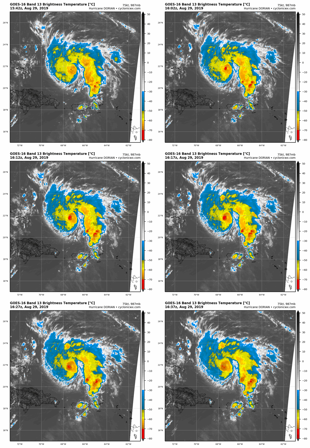
Outflow is improving to the south and west. Probably a sign that the shear is decreasing somewhat.
1 likes   
Noel '07, Kyle '08, Earl '10, Arthur '14, Dorian '19, Teddy '20, Lee '23

hurricaneCW
Category 5
Category 5
Posts: 1794
Joined: Wed Mar 03, 2010 6:20 am
Location: Toms River, NJ

Re: ATL: DORIAN - Hurricane - Discussion

#2684 Postby hurricaneCW » Thu Aug 29, 2019 11:51 am

Astromanía wrote:Still fighting with dry air, how much time left before conditions improve?


I don't think we'll see any meaningful intensification until it turns toward the wnw. I could see a scenario where it doesn't bomb out until a day or two before LF ala Michael, hopefully that's not the case.
0 likes   

Sciencerocks
Category 5
Category 5
Posts: 9263
Age: 39
Joined: Thu Jul 06, 2017 1:51 am

Re: ATL: DORIAN - Hurricane - Discussion

#2685 Postby Sciencerocks » Thu Aug 29, 2019 11:51 am

Image
2 likes   

User avatar
NotSparta
Professional-Met
Professional-Met
Posts: 1676
Age: 23
Joined: Fri Aug 18, 2017 8:24 am
Location: Naples, FL
Contact:

Re: ATL: DORIAN - Hurricane - Discussion

#2686 Postby NotSparta » Thu Aug 29, 2019 11:52 am

The S shear has eased, shown by healthier outflow on the south side, but Dorian continues to struggle with dry air

Image
1 likes   
This post was probably an opinion of mine, and in no way is official. Please refer to http://www.hurricanes.gov for official tropical analysis and advisories.

My website, with lots of tropical wx graphics, including satellite and recon: http://cyclonicwx.com

dspguy
Tropical Depression
Tropical Depression
Posts: 61
Joined: Wed Sep 06, 2017 2:26 pm
Location: Charleston, SC

Re: ATL: DORIAN - Hurricane - Discussion

#2687 Postby dspguy » Thu Aug 29, 2019 11:53 am

kaystorm94 wrote:So we are flying into Orlando on Wednesday, the 4th (Disney). Will this hurricane be out by then? I don't want to jump the gun and cancel our trip or move it. It has been planned for some time now. Flying from Houston to Orlando.

I would call up Disney (or wherever you booked lodging). Find out if there is a contingency plan to reschedule or get a refund. Your tickets themselves would be good for a while. I think they don't expire now for up to a year or so. Your flight is a different story.

Given the dates you gave, Sep 4th is just two days beyond the current expected landfall. If it does come in as Cat 2+ anywhere between Jacksonville and Miami, it isn't like things will be back to normal in 48 hours. Disney is something else, so maybe they'd be open. You might be looking at a huge headache trying to fly in and fly out. If you can't recoup most of your cost, maybe just wait and see. Maybe the storm will head north or will grow weaker.

Might work out better though. I hear the lines for Galaxy's Edge are 5+ hours right now. Maybe in a few months it'll only be 4 hours.
Last edited by dspguy on Thu Aug 29, 2019 11:54 am, edited 1 time in total.
0 likes   

User avatar
Blinhart
Category 5
Category 5
Posts: 2081
Age: 48
Joined: Thu Sep 08, 2011 3:13 pm
Location: Crowley, La.

Re: ATL: DORIAN - Hurricane - Discussion

#2688 Postby Blinhart » Thu Aug 29, 2019 11:54 am

hurricaneCW wrote:
Astromanía wrote:Still fighting with dry air, how much time left before conditions improve?


I don't think we'll see any meaningful intensification until it turns toward the wnw. I could see a scenario where it doesn't bomb out until a day or two before LF ala Michael, hopefully that's not the case.


As soon as this first EWRC is completely done, don't be surprised to see it strengthen up to around 110 mph in short order and then start another EWRC. I can see this system go through 2 to 5 more EWRC, just depending on how slow it does go.
0 likes   
Personal Forecast Disclaimer:
The posts in this forum are NOT official forecast and should not be used as such. They are just the opinion of the poster and may or may not be backed by sound meteorological data. They are NOT endorsed by any professional institution or storm2k.org. For official information, please refer to the NHC and NWS products.

skillz305
Category 1
Category 1
Posts: 283
Joined: Sat Sep 08, 2018 11:10 am
Location: Miami, Florida --> Vero Beach, Florida

Re: ATL: DORIAN - Hurricane - Discussion

#2689 Postby skillz305 » Thu Aug 29, 2019 11:58 am

Vero Beach, FL here. Our stomachs are churning....
3 likes   
:flag:Hurricanes: Andrew 1992 - Irene 1999 - Frances 2004 - Jeanne 2004 - Katrina 2005 - Wilma 2005 - Matthew 2016 - Irma 2017 - Ian 2022 - Nicole 2022 - Milton 2024

Pughetime12
Tropical Low
Tropical Low
Posts: 32
Joined: Thu Oct 06, 2016 1:07 pm

Re: ATL: DORIAN - Hurricane - Discussion

#2690 Postby Pughetime12 » Thu Aug 29, 2019 12:02 pm

kaystorm94 wrote:So we are flying into Orlando on Wednesday, the 4th (Disney). Will this hurricane be out by then? I don't want to jump the gun and cancel our trip or move it. It has been planned for some time now. Flying from Houston to Orlando.


"Sorry folks, park's closed. Mouse out front shoulda told ya"
9 likes   

User avatar
Jr0d
S2K Supporter
S2K Supporter
Posts: 1421
Joined: Tue Aug 27, 2019 10:52 am
Location: Cayo Hueso

Re: ATL: DORIAN - Hurricane - Discussion

#2691 Postby Jr0d » Thu Aug 29, 2019 12:05 pm

Blinhart wrote:
Jr0d wrote:
StormingB81 wrote:WFTV stated that it is possible Brevard County will do a MANDATORY evacuation for EVERY ONE EAST of 95...Which is where I am..I can't imagine the traffic


Generally it is east of US 1. Maybe they were mistaken.


I'm pretty sure for Cat 3 and lower it is US1, but for Cat 4 and higher it would be I-95/Florida Turnpike.


Never in my lifetime(except for trailer parks) have I ever seen a mandatory evacuation that went further than US 1 in Brevard. Also the turnpike does not go through Brevard at all.

Even the most extreme surge will not make it past US1.

There can be a problem with evacuating too many people. This is where it is crucial to know how strong your structure is, how high you are above sea level(storm surge risk) and a have plan before an evacuation order is issued.

What no one wants to see is people stranded on the road because of traffic jams when bad stuff gets here.
2 likes   

User avatar
BensonTCwatcher
Category 5
Category 5
Posts: 1046
Joined: Sat Aug 28, 2004 10:11 pm
Location: Southport NC

Re: ATL: DORIAN - Hurricane - Discussion

#2692 Postby BensonTCwatcher » Thu Aug 29, 2019 12:07 pm

Dry air is still being pulled from the mona passage and across Hisp. Dorian will shut that down shortly with the southern feeder band portion of his moisture envelope. Later today should be pretty favorable for development.
0 likes   

hohnywx
Category 2
Category 2
Posts: 511
Age: 34
Joined: Sun Jul 19, 2009 8:34 pm
Location: Hastings-on-Hudson, NY

Re: ATL: DORIAN - Hurricane - Discussion

#2693 Postby hohnywx » Thu Aug 29, 2019 12:09 pm

Jr0d wrote:
Blinhart wrote:
Jr0d wrote:
Generally it is east of US 1. Maybe they were mistaken.


I'm pretty sure for Cat 3 and lower it is US1, but for Cat 4 and higher it would be I-95/Florida Turnpike.


Never in my lifetime(except for trailer parks) have I ever seen a mandatory evacuation that went further than US 1 in Brevard. Also the turnpike does not go through Brevard at all.

Even the most extreme surge will not make it past US1.

There can be a problem with evacuating too many people. This is where it is crucial to know how strong your structure is, how high you are above sea level(storm surge risk) and a have plan before an evacuation order is issued.

What no one wants to see is people stranded on the road because of traffic jams when bad stuff gets here.


According to the map on their website, there's a very small area west of I-95 that would be included in the most extreme evacuation order: https://www.brevardfl.gov/EmergencyMana ... Evacuation. Most areas are east of I-95.
0 likes   

Michele B
S2K Supporter
S2K Supporter
Posts: 1115
Joined: Thu Aug 25, 2016 8:08 am
Location: SWFL

Re: ATL: DORIAN - Hurricane - Discussion

#2694 Postby Michele B » Thu Aug 29, 2019 12:10 pm

Aric Dunn wrote:
tolakram wrote:I'm in the close scrape to out to sea camp but my confidence level is about 2%. Hopefully by this time tomorrow we'll be a lot more confident.


Lets see if this holds after the 12z..

Right now the best consensus, we are privy to say, is south of current nhc forcast. that says a lot.

"It should be noted that the ECMWF, UKMET, and HFIP corrected
consensus models remain south of the official forecast"


So if the ECMWF, UKMET, and HFIP - which I don't know about....btw, are saying SOUTH of current nhc forecast, does that exclude a possible "scrape and brush with coast" scenario?
0 likes   
Cleo - 1964, Betsy - 1965, David - 1979, Andrew - 1992, Charlie (Francis, Ivan, Jeanne) - 2004, Irma - 2017, Ian - 2022

User avatar
ScottNAtlanta
Category 5
Category 5
Posts: 2419
Joined: Sat May 25, 2013 3:11 pm
Location: Atlanta, GA

Re: ATL: DORIAN - Hurricane - Discussion

#2695 Postby ScottNAtlanta » Thu Aug 29, 2019 12:12 pm

Blinhart wrote:
hurricaneCW wrote:
Astromanía wrote:Still fighting with dry air, how much time left before conditions improve?


I don't think we'll see any meaningful intensification until it turns toward the wnw. I could see a scenario where it doesn't bomb out until a day or two before LF ala Michael, hopefully that's not the case.


As soon as this first EWRC is completely done, don't be surprised to see it strengthen up to around 110 mph in short order and then start another EWRC. I can see this system go through 2 to 5 more EWRC, just depending on how slow it does go.


I think 5 might be excessive 2 might even be excessive. There is no skill right now in predicting when these occur. Just know that with every EWRC you greatly expand the wind field, and we really dont need that to happen. I have seen strong storms that deepened and never had one and some that seem to have them over and over Michael and Florence are good examples of each scenario. Florence seemed to have one every five minutes.
1 likes   
The posts in this forum are NOT official forecast and should not be used as such. They are just the opinion of the poster and may or may not be backed by sound meteorological data. They are NOT endorsed by any professional institution or storm2k.org. For official information, please refer to the NHC and NWS products.

NFLnut
Category 2
Category 2
Posts: 541
Joined: Sun Aug 29, 2004 7:37 pm

Re: ATL: DORIAN - Hurricane - Discussion

#2696 Postby NFLnut » Thu Aug 29, 2019 12:13 pm

Jr0d wrote:
Blinhart wrote:
Jr0d wrote:
Generally it is east of US 1. Maybe they were mistaken.


I'm pretty sure for Cat 3 and lower it is US1, but for Cat 4 and higher it would be I-95/Florida Turnpike.


Never in my lifetime(except for trailer parks) have I ever seen a mandatory evacuation that went further than US 1 in Brevard. Also the turnpike does not go through Brevard at all.

Even the most extreme surge will not make it past US1.

There can be a problem with evacuating too many people. This is where it is crucial to know how strong your structure is, how high you are above sea level(storm surge risk) and a have plan before an evacuation order is issued.

What no one wants to see is people stranded on the road because of traffic jams when bad stuff gets here.


Agree. Evacuating all the way west to I95 (IMHO) would create way more problems than it would solve! Not saying it won't happen for maybe a 5, but I just don't see evac much west of US1. Then again, I'm not paid the city official big bucks to make those decisions.
1 likes   

Michele B
S2K Supporter
S2K Supporter
Posts: 1115
Joined: Thu Aug 25, 2016 8:08 am
Location: SWFL

Re: ATL: DORIAN - Hurricane - Discussion

#2697 Postby Michele B » Thu Aug 29, 2019 12:14 pm

cjrciadt wrote:Worse case from this track. I may get Cat 2 sustanied winds even in the heart of CFL!!


Yeah, just like with Charley in 2004, we're in the "middle of the state...." and ALL my neighbors thought "We're too far inland to be impacted by that...."

And they found out! "INLAND" in FL doesn't have the same meaning as other states!

Unless this thing is ABOVE our latitude by 50 or so miles, we're boarding up.....
0 likes   
Cleo - 1964, Betsy - 1965, David - 1979, Andrew - 1992, Charlie (Francis, Ivan, Jeanne) - 2004, Irma - 2017, Ian - 2022

User avatar
Stormi
Tropical Depression
Tropical Depression
Posts: 86
Age: 37
Joined: Sun Aug 18, 2019 10:04 pm
Location: Northeast FL

Re: ATL: DORIAN - Hurricane - Discussion

#2698 Postby Stormi » Thu Aug 29, 2019 12:15 pm

will759227 wrote:Well, off to find a generator. May still be able to get lucky at costco. You never know. I just want to run the freezer and fridge and if possible dehumidifier. .. Think a 3500 unit can run that?


It may be close. For refrigerators/freezers I believe you are supposed to find the running wattage & then triple that number which will give you your starting wattage. Check that first & definitely plug all 3 in waiting a bit between each.
0 likes   

User avatar
flamingosun
S2K Supporter
S2K Supporter
Posts: 198
Joined: Wed Sep 15, 2004 4:51 am
Location: Merritt Island, FL

Re: ATL: DORIAN - Hurricane - Discussion

#2699 Postby flamingosun » Thu Aug 29, 2019 12:16 pm

Jr0d wrote:
StormingB81 wrote:WFTV stated that it is possible Brevard County will do a MANDATORY evacuation for EVERY ONE EAST of 95...Which is where I am..I can't imagine the traffic


Generally it is east of US 1. Maybe they were mistaken.


Or just the barrier islands
Last edited by flamingosun on Thu Aug 29, 2019 12:16 pm, edited 1 time in total.
0 likes   

User avatar
Condor
Tropical Depression
Tropical Depression
Posts: 86
Joined: Wed Sep 12, 2018 3:10 pm
Location: International Space Station

Re: ATL: DORIAN - Hurricane - Discussion

#2700 Postby Condor » Thu Aug 29, 2019 12:16 pm

What time is the next EURO model ?
0 likes   
The following post is NOT an official forecast and should not be used as such. It is just the opinion of the poster and may or may not be backed by sound meteorological data. It is NOT endorsed by any professional institution including storm2k.org For Official Information please refer to the NHC and NWS products.


Return to “2019”

Who is online

Users browsing this forum: No registered users and 25 guests