
https://twitter.com/derekortt/status/1167293012931727360
ATL: DORIAN - Post-Tropical - Discussion
Moderator: S2k Moderators
-
WeatherOrKnot
- Tropical Depression

- Posts: 80
- Joined: Fri Sep 02, 2011 10:24 am
Re: ATL: DORIAN - Hurricane - Discussion
What can the earlier turn (provided it verifies) do to the track?
0 likes
-
ConvergenceZone
.gif)
- Category 5

- Posts: 5241
- Joined: Fri Jul 29, 2005 1:40 am
- Location: Northern California
Re: ATL: DORIAN - Hurricane - Discussion
WeatherOrKnot wrote:What can the earlier turn (provided it verifies) do to the track?
if it turns North quicker than currently anticipated(finds a weakness in the ridge), it could either hug the coastline or remain offshore. Even the weather channel said tonight that remaining offshore is still a possibility, mostly due to the increasingly offshore ensembles of the euro, and the operational euro just hugging the east coast of florida
1 likes
-
Chris_in_Tampa
- Category 5
- Posts: 5101
- Age: 42
- Joined: Thu Jun 21, 2007 11:06 pm
- Location: Tampa, Florida, USA
- Contact:
Re: ATL: DORIAN - Hurricane - Discussion
Thursday 6:36:54pm to Friday 12:30:54am AST:

From:
https://rammb-slider.cira.colostate.edu ... =750&y=819
From:
https://rammb-slider.cira.colostate.edu ... =750&y=819
3 likes
-
bamajammer4eva
- Category 4

- Posts: 907
- Joined: Sun Apr 18, 2010 3:21 am
- Location: Ozark, AL
Re: ATL: DORIAN - Hurricane - Discussion
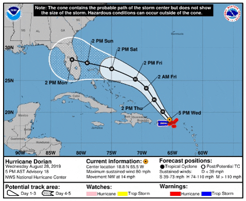
Uh-Oh The NHC 'Cone' seems to be getting eaten up by a circle!
9 likes

Re: ATL: DORIAN - Hurricane - Discussion
bamajammer4eva wrote:Uh-Oh The NHC 'Cone' seems to be getting eaten up by a circle!
https://media.giphy.com/media/l50Qb9OzGEhrFSvvsz/giphy.gif
I don't think I've ever seen the track just get shorter and shorter with each advisory like this before.
Also Dorian proving yet again that satellite appearance can only go so far--I'd think it was barely a hurricane right now if not for actual measurements.

12 likes
The above post is not official and should not be used as such. It is the opinion of the poster and may or may not be backed by sound meteorological data. It is not endorsed by any professional institution or storm2k.org. For official information, please refer to the NHC and NWS products.
-
tropicwatch

- Category 5
- Posts: 3426
- Age: 62
- Joined: Sat Jun 02, 2007 10:01 am
- Location: Panama City Florida
- Contact:
Re: ATL: DORIAN - Hurricane - Discussion
A wobble a little northward according to latest pass it looks like but Dorian is a little west of forecast track.
1 likes
Tropicwatch
Agnes 72', Eloise 75, Elena 85', Kate 85', Charley 86', Florence 88', Beryl 94', Dean 95', Erin 95', Opal 95', Earl 98', Georges 98', Ivan 2004', Arlene 2005', Dennis 2005', Ida 2009' Debby 2012' Irma 2017' Michael 2018'
Agnes 72', Eloise 75, Elena 85', Kate 85', Charley 86', Florence 88', Beryl 94', Dean 95', Erin 95', Opal 95', Earl 98', Georges 98', Ivan 2004', Arlene 2005', Dennis 2005', Ida 2009' Debby 2012' Irma 2017' Michael 2018'
-
Astromanía
- Category 2

- Posts: 793
- Age: 27
- Joined: Sat Aug 25, 2018 10:34 pm
- Location: Monterrey, N.L, México
Re: ATL: DORIAN - Hurricane - Discussion
1 likes
-
toad strangler

- S2K Supporter

- Posts: 4546
- Joined: Sun Jul 28, 2013 3:09 pm
- Location: Earth
- Contact:

-
toad strangler
- S2K Supporter
- Posts: 4546
- Joined: Sun Jul 28, 2013 3:09 pm
- Location: Earth
- Contact:
-
Yellow Evan

- Professional-Met

- Posts: 16222
- Age: 27
- Joined: Fri Jul 15, 2011 12:48 pm
- Location: Henderson, Nevada/Honolulu, HI
- Contact:
Re: ATL: DORIAN - Hurricane - Discussion
Astromanía wrote::uarrow: It is really an ugly cat 2 hurricane but well we have recon, in EPAC this would be a TS maybe a cat 1 at best but not more based only on dvorak.
SAB is at T4.5 so probably 75-80 without Recon.
1 likes
-
craptacular
- Category 2
- Posts: 581
- Joined: Wed Aug 02, 2006 9:17 pm
- Location: The Mad City, WI
Re: ATL: DORIAN - Hurricane - Discussion
panamatropicwatch wrote:A wobble a little northward according to latest pass it looks like but Dorian is a little west of forecast track.
Yeah, even with that last pass finding the center a little further north, it still works out to 301 degrees from the 2nd to the 5th pass of this mission, when the last advisory had the motion at 325.
0 likes

Re: ATL: DORIAN - Hurricane - Discussion
Why does he look squished from NW to SE?
0 likes
Personal Forecast Disclaimer:
The posts in this forum are NOT official forecast and should not be used as such. They are just the opinion of the poster and may or may not be backed by sound meteorological data. They are NOT endorsed by any professional institution or storm2k.org. For official information, please refer to the NHC and NWS products.
The posts in this forum are NOT official forecast and should not be used as such. They are just the opinion of the poster and may or may not be backed by sound meteorological data. They are NOT endorsed by any professional institution or storm2k.org. For official information, please refer to the NHC and NWS products.

Re: ATL: DORIAN - Hurricane - Discussion
SoupBone wrote:Why does he look squished from NW to SE?
Interaction with the ridge
0 likes
-
Aric Dunn
- Category 5
- Posts: 21238
- Age: 43
- Joined: Sun Sep 19, 2004 9:58 pm
- Location: Ready for the Chase.
- Contact:
Re: ATL: DORIAN - Hurricane - Discussion
Kat5 wrote:SoupBone wrote:Why does he look squished from NW to SE?
Interaction with the ridge
being pulled to the wnw by the upper low. which looks like its causing it to turn earlier..
it is pretty clear the ull is pulling to the wnw
that and that upper low is really shooting west to soon wsw.

5 likes
Note: If I make a post that is brief. Please refer back to previous posts for the analysis or reasoning. I do not re-write/qoute what my initial post said each time.
If there is nothing before... then just ask
Space & Atmospheric Physicist, Embry-Riddle Aeronautical University,
I believe the sky is falling...
If there is nothing before... then just ask
Space & Atmospheric Physicist, Embry-Riddle Aeronautical University,
I believe the sky is falling...
-
Tailspin
Re: ATL: DORIAN - Hurricane - Discussion
Yellow Evan wrote:Astromanía wrote::uarrow: It is really an ugly cat 2 hurricane but well we have recon, in EPAC this would be a TS maybe a cat 1 at best but not more based only on dvorak.
SAB is at T4.5 so probably 75-80 without Recon.
Are you sure about that with adt under T4. 3.7 / 989.0mb/ 59.0kt
0 likes
Re: ATL: DORIAN - Hurricane - Discussion
Aric Dunn wrote:Kat5 wrote:SoupBone wrote:Why does he look squished from NW to SE?
Interaction with the ridge
being pulled to the wnw by the upper low. which looks like its causing it to turn earlier..
it is pretty clear the ull is pulling to the wnw
that and that upper low is really shooting west to soon wsw.
https://imgshare.io/images/2019/08/29/22.gif
Looks like it's inducing some southerly shear as well. Any chance that could keep it from strengthening further?
2 likes
The above post is not official and should not be used as such. It is the opinion of the poster and may or may not be backed by sound meteorological data. It is not endorsed by any professional institution or storm2k.org. For official information, please refer to the NHC and NWS products.
-
SouthFloridawx

- S2K Supporter
- Posts: 8346
- Age: 47
- Joined: Tue Jul 26, 2005 1:16 am
- Location: Sarasota, FL
- Contact:
Re: ATL: DORIAN - Hurricane - Discussion
I don't know everyone. This is really starting to look scary. Once that ULL is out of the way, it's got nothing to hinder development. We're going to be looking at a pretty intense storm hitting Florida.
1 likes
Who is online
Users browsing this forum: No registered users and 12 guests