ATL: DORIAN - Post-Tropical - Discussion
Moderator: S2k Moderators
-
Weatherboy1

- Category 5

- Posts: 1190
- Age: 50
- Joined: Mon Jul 05, 2004 1:50 pm
- Location: Jupiter/Sarasota, FL
Re: ATL: DORIAN - Hurricane - Discussion
Concur that it looks like an eye is about to clear out. Not sure if that's a prelude to strengthening, but I'd be inclined to say yes. Definitely getting ready for a possible direct hit here in Jupiter!
0 likes
-
gatorcane

- S2K Supporter

- Posts: 23708
- Age: 48
- Joined: Sun Mar 13, 2005 3:54 pm
- Location: Boca Raton, FL
Re: ATL: DORIAN - Hurricane - Discussion
Bob R wrote:gatorcane wrote:I think the thing to watch for folks that live south of West Palm is whether the WSW turn as it approaches the coast really happens. The UKMET/ICON/HMON/NAM show this and the Euro to some extent.
You may ask why it would do that? Because there is an upper high that is supposed the build over Northern Florida. Some models think the NE flow around that high over South Florida would be enough to nudge a strong Dorian more WSW despite the 500mb ridge weakening some.
gatorcane:
Can you post any graphic of this upper level high?
2 likes

Re: ATL: DORIAN - Hurricane - Discussion
Evil Jeremy wrote:fci wrote:Evil Jeremy wrote:
Cantore just asked NHC director Graham this about 15 minutes ago. Graham said it's a discussion they will have in the office today. He pointed to the expected TS winds arriving Sunday 8pm and discussed the 48 hour guideline. You would think the watches will be issued at 5pm. 11pm doesn't make sense, everyone's going to bed. Send the message when people are getting out of work. And tomorrow morning is eating into the 48 hours.
With the slowing of the storm and forecast that my area (Lake Worth) would be closest early Tuesday morning; 48 hour guideline would indicate Hurricane Watches Saturday night or Sunday morning
No, they go by earliest arrival of TS winds
I stand corrected. Might still be correct if the slow down occurs and there might not be watches until Late Saturday; but you are right.
1 likes
Personal Forecast Disclaimer:
My posts are just my opinion and are most likely not backed by sound meteorological data. They are NOT endorsed by any professional institution or storm2k.org. For official information, please refer to the NHC and NWS products.
Bottom line is that I am just expressing my opinion!!!
My posts are just my opinion and are most likely not backed by sound meteorological data. They are NOT endorsed by any professional institution or storm2k.org. For official information, please refer to the NHC and NWS products.
Bottom line is that I am just expressing my opinion!!!
-
northjaxpro

- S2K Supporter
- Posts: 8900
- Joined: Mon Sep 27, 2010 11:21 am
- Location: Jacksonville, FL
Re: ATL: DORIAN - Hurricane - Discussion
newtotex wrote:Jr0d wrote:NDG wrote:Who remembers when John Hope used to say on TWC that the flow of the high cirrus clouds was a sign to follow of where the Hurricane was headed? So true!
Man I do miss John Hope. I pretty much stopped watching the weather channel after he passed away.
I can help but wonder what we would have to say about Dorian.
Was just about to say that. When I was a kid I would glue to the TV whenever he or Greg Forbes would come on
The late, great John Hope!!
LEGEND! He was a truly remarkable hurricane forecaster, The Weather Channel never was the same after he passed away. Cantore has tried to take the mantle he left behind as the expert, but he can never surpass Hope!
R.I. P.
Last edited by northjaxpro on Fri Aug 30, 2019 8:58 am, edited 2 times in total.
2 likes
NEVER, EVER SAY NEVER in the tropics and weather in general, and most importantly, with life itself!!
________________________________________________________________________________________
Fay 2008 Beryl 2012 Debby 2012 Colin 2016 Hermine 2016 Julia 2016 Matthew 2016 Irma 2017 Dorian 2019
________________________________________________________________________________________
Fay 2008 Beryl 2012 Debby 2012 Colin 2016 Hermine 2016 Julia 2016 Matthew 2016 Irma 2017 Dorian 2019

Re: ATL: DORIAN - Hurricane - Discussion
To my untrained eye, it appears the eye is trying to form somewhere near 25.25N 70W on the visible and IR. That would put it a little more north than most models have it pegged at
0 likes
-
TallyTracker
- Category 2

- Posts: 787
- Joined: Thu Oct 11, 2018 2:46 pm
Re: ATL: DORIAN - Hurricane - Discussion
The eye is popping out on infrared. Also seems to be a small dry spot as well just outside the eyewall. Could be a transient feature.
1 likes
Fran '96, Georges '98, Gordon '00, Gabrielle '01, Charley '04, Frances '04, Jeanne '04, Barry '07, Fay '08, Debby '12, Matthew '16, Emily '17, Irma '17, Michael ‘18, Elsa ‘21, Fred ‘21, Mindy ‘21, Nicole ‘22, Idalia ‘23, Debby ‘24, Helene ‘24
-
cainjamin

- Tropical Storm

- Posts: 173
- Age: 34
- Joined: Mon Apr 17, 2017 1:38 pm
- Location: Nova Scotia, Canada
Re: ATL: DORIAN - Hurricane - Discussion
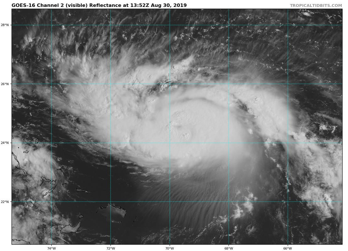
I agree - looks like the eye is about to pop.
2 likes
Noel '07, Kyle '08, Earl '10, Arthur '14, Dorian '19, Teddy '20, Lee '23

Re: ATL: DORIAN - Hurricane - Discussion
gatorcane wrote:Bob R wrote:gatorcane wrote:I think the thing to watch for folks that live south of West Palm is whether the WSW turn as it approaches the coast really happens. The UKMET/ICON/HMON/NAM show this and the Euro to some extent.
You may ask why it would do that? Because there is an upper high that is supposed the build over Northern Florida. Some models think the NE flow around that high over South Florida would be enough to nudge a strong Dorian more WSW despite the 500mb ridge weakening some.
gatorcane:
Can you post any graphic of this upper level high?
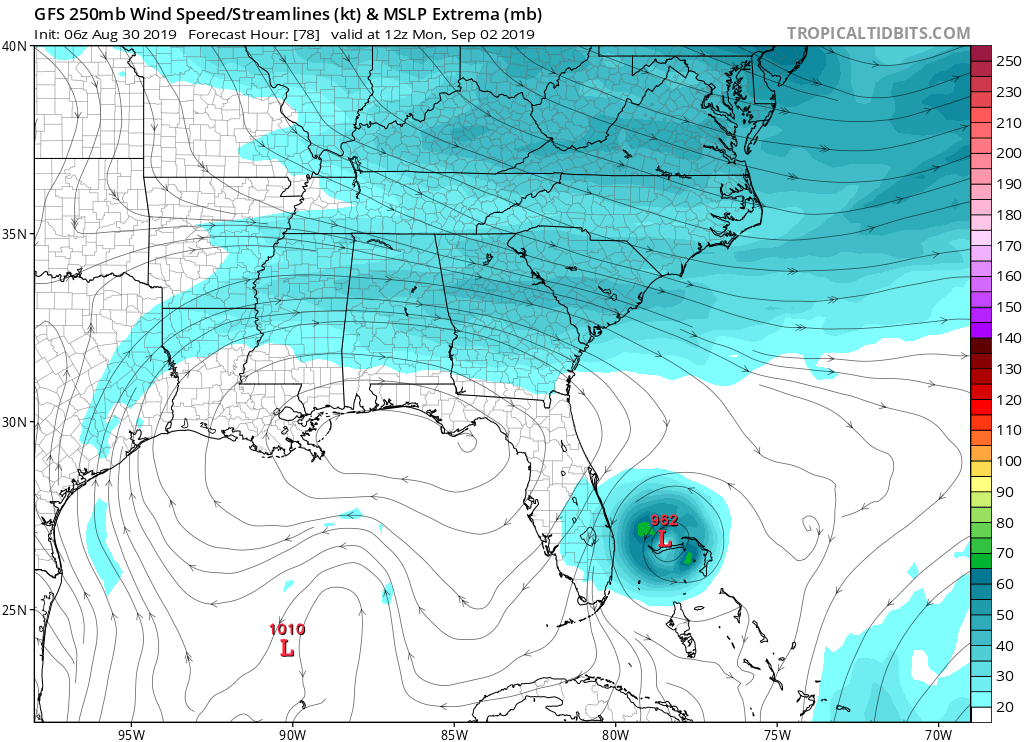
https://i.postimg.cc/P5VJJFbH/gfs-uv250-seus-14.png
This is what Levi C mentioned last night on his youtube update, about this UL ridge forecasted to build NW of Dorian that might compete with the weakness building to the north of Dorian by then to at least push it W if not WSW until a bigger weakness develops to pull it north.
1 likes
-
supercane4867
- Category 5
- Posts: 4966
- Joined: Wed Nov 14, 2012 10:43 am

-
emeraldislenc
- Category 2
- Posts: 601
- Joined: Fri Aug 24, 2012 4:49 pm
- Location: Emerald Isle NC
Re: ATL: DORIAN - Hurricane - Discussion
Yes John Hope was the best. I sure miss him. The Weather Channel has not been the same.
4 likes

Re: ATL: DORIAN - Hurricane - Discussion
Two counterpoising eyewall hot towers rotating.
Perfect latent heat transfer into the core.
Will see an eye pop shortly.
Perfect latent heat transfer into the core.
Will see an eye pop shortly.
4 likes
Re: ATL: DORIAN - Hurricane - Discussion
Crazy how the background surface pressure around Dorian is still in the 1014mb-1016mb range. 
2 likes
-
NotSparta

- Professional-Met

- Posts: 1676
- Age: 24
- Joined: Fri Aug 18, 2017 8:24 am
- Location: Naples, FL
- Contact:
Re: ATL: DORIAN - Hurricane - Discussion
Appears there's an eye trying to clear
1 likes
This post was probably an opinion of mine, and in no way is official. Please refer to http://www.hurricanes.gov for official tropical analysis and advisories.
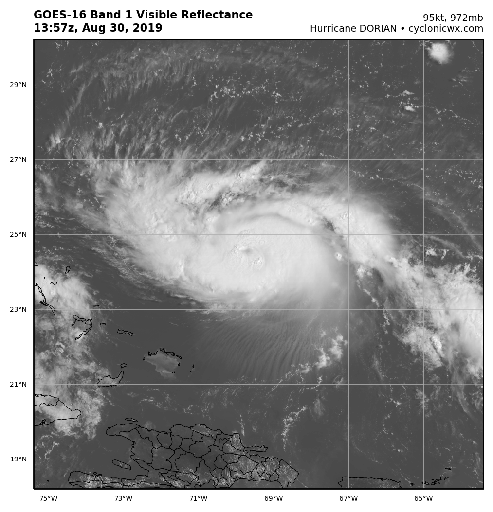
My website, with lots of tropical wx graphics, including satellite and recon: http://cyclonicwx.com
My website, with lots of tropical wx graphics, including satellite and recon: http://cyclonicwx.com


Re: ATL: DORIAN - Hurricane - Discussion
jfk08c wrote:To my untrained eye, it appears the eye is trying to form somewhere near 25.25N 70W on the visible and IR. That would put it a little more north than most models have it pegged at
Still below 25n by a decent amount.
0 likes
Re: ATL: DORIAN - Hurricane - Discussion
Could someone attempt to explain this for me? On the GOES16 IR, you can clearly see the eye forming above the tip of Florida which is at roughly 25N. However, looking at the TropicalTidbits IR, it looks to be forming south of that. Does that just have to do with the format or what?

0 likes

Re: ATL: DORIAN - Hurricane - Discussion
I wish I could remember the source, but regarding the Cat 4 down to Cat1...he explained that you need to look at the predicted time line. It makes landfall as as a Cat4 but sits over land for 24 hours which will cause it to lose strength to a Cat1. Is this plausible?
0 likes
Alicia, Rita, Ike, Harvey and Beryl...moved to Splendora lol
-
tarheelprogrammer

- S2K Supporter
- Posts: 1793
- Joined: Mon Mar 28, 2016 9:25 pm
- Location: Raleigh, NC area (Garner, NC)
Re: ATL: DORIAN - Hurricane - Discussion
Did dry air get into the core of Dorian again? Weird spot right above the eye looks like a dry spot on IR.
0 likes
My posts are not official forecasts. They are just my opinion and may or may not be backed by sound meteorological data. They are NOT endorsed by any professional institution or storm2k.org. For official information, please refer to the NHC and NWS products.

Re: ATL: DORIAN - Hurricane - Discussion
emeraldislenc wrote:Yes John Hope was the best. I sure miss him. The Weather Channel has not been the same.
At 2 minutes, he have John Hope discussing Andrew when it was just north and west of where Dorian is now. Interesting to look at the satellite of Andrew then vs Dorian today.
https://m.youtube.com/watch?v=4AWI8uGflR4&t=219s
Last edited by Jr0d on Fri Aug 30, 2019 9:13 am, edited 3 times in total.
0 likes
-
Chris_in_Tampa
- Category 5
- Posts: 5101
- Age: 42
- Joined: Thu Jun 21, 2007 11:06 pm
- Location: Tampa, Florida, USA
- Contact:
Re: ATL: DORIAN - Hurricane - Discussion
Ritzcraker wrote:Anyone else notice the erratic flight pattern on one of the planes?
They might have been flying over NOAA's Hurricane Underwater Gliders again. This from two days ago:
https://noaahrd.wordpress.com/2019/08/2 ... 9-7pm-edt/
Map of gliders with data at the bottom of the page:
https://www.aoml.noaa.gov/phod/goos/gli ... ations.php
I didn't check to see if that matches where the plane was.
About the gliders:
https://www.aoml.noaa.gov/phod/goos/gli ... rs-project
NOAA HRD Blog:
https://noaahrd.wordpress.com/
Information about NOAA missions.
NOAA data on hurricanes, like NOAA mission paths for some missions:
https://www.aoml.noaa.gov/hrd/data_sub/hurr.html
For Dorian:
https://www.aoml.noaa.gov/hrd/Storm_pag ... ssion.html
2 likes
Who is online
Users browsing this forum: No registered users and 16 guests