WPAC: KAMMURI - Post-Tropical
Moderator: S2k Moderators
- mrbagyo
- Category 5
- Posts: 3617
- Age: 32
- Joined: Thu Apr 12, 2012 9:18 am
- Location: 14.13N 120.98E
- Contact:
Re: WPAC: KAMMURI - Typhoon
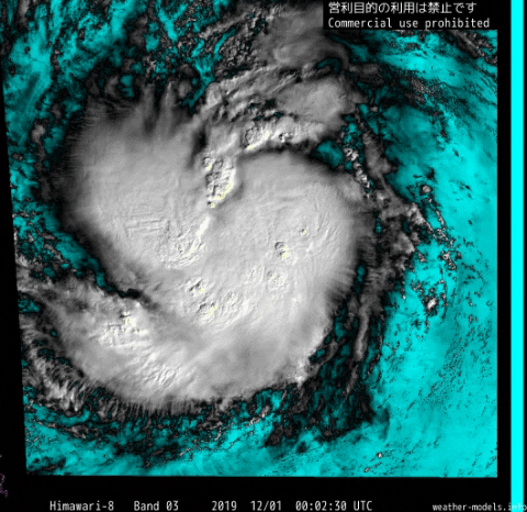
Durian and Nock-ten passed within 65 nautical miles from Kammuri's current location as Category 1 typhoons, both ended up becoming high-end Cat 4 landfalls in Bicol peninsula.
Both have better CDO structure though at that point vs Kammuri.
0 likes
The posts in this forum are NOT official forecast and should not be used as such. They are just the opinion of the poster and may or may not be backed by sound meteorological data. They are NOT endorsed by any professional institution or storm2k.org. For official information, please refer to RSMC, NHC and NWS products.
Re: WPAC: KAMMURI - Typhoon
Trying to curl more
0 likes
Very useful information on the Dvorak Technique --
https://severe.worldweather.wmo.int/TCF ... kBeven.pdf
Re: WPAC: KAMMURI - Typhoon
0 likes
ヤンデレ女が寝取られるているのを見たい!!!
ECMWF ensemble NWPAC plots: https://ecmwfensnwpac.imgbb.com/
Multimodel NWPAC plots: https://multimodelnwpac.imgbb.com/
GFS Ensemble NWPAC plots (16 & 35 day forecast): https://gefsnwpac.imgbb.com/
Plots updated automatically
ECMWF ensemble NWPAC plots: https://ecmwfensnwpac.imgbb.com/
Multimodel NWPAC plots: https://multimodelnwpac.imgbb.com/
GFS Ensemble NWPAC plots (16 & 35 day forecast): https://gefsnwpac.imgbb.com/
Plots updated automatically
Re: WPAC: KAMMURI - Typhoon
Minimal typhoon
While JMA
29W KAMMURI 191201 0000 13.3N 131.4E WPAC 65 974
While JMA
TY 1928 (Kammuri)
Issued at 00:45 UTC, 1 December 2019
<Analysis at 00 UTC, 1 December>
Scale -
Intensity -
Center position N13°00' (13.0°)
E130°40' (130.7°)
Direction and speed of movement W 25 km/h (14 kt)
Central pressure 955 hPa
Maximum wind speed near center 40 m/s (80 kt)
Maximum wind gust speed 60 m/s (115 kt)
≥ 50 kt wind area ALL 130 km (70 NM)
≥ 30 kt wind area NW 500 km (270 NM)
SE 280 km (150 NM)
0 likes
ヤンデレ女が寝取られるているのを見たい!!!
ECMWF ensemble NWPAC plots: https://ecmwfensnwpac.imgbb.com/
Multimodel NWPAC plots: https://multimodelnwpac.imgbb.com/
GFS Ensemble NWPAC plots (16 & 35 day forecast): https://gefsnwpac.imgbb.com/
Plots updated automatically
ECMWF ensemble NWPAC plots: https://ecmwfensnwpac.imgbb.com/
Multimodel NWPAC plots: https://multimodelnwpac.imgbb.com/
GFS Ensemble NWPAC plots (16 & 35 day forecast): https://gefsnwpac.imgbb.com/
Plots updated automatically
Re: WPAC: KAMMURI - Typhoon
0 likes
Very useful information on the Dvorak Technique --
https://severe.worldweather.wmo.int/TCF ... kBeven.pdf
- wxman57
- Moderator-Pro Met
- Posts: 22484
- Age: 66
- Joined: Sat Jun 21, 2003 8:06 pm
- Location: Houston, TX (southwest)
Re: WPAC: KAMMURI - Typhoon
No way this has been a typhoon for the past 24 hours. Closer to 50 kts than JMA's 80 kt 10-min wind. They had the center way too far west, as did Dvorak estimates. The center has been east of the convection for over 24 hours. It does look like it's near the convection now, though. Should see it really attain typhoon strength in the next 6 hours.
5 likes
Re: WPAC: KAMMURI - Typhoon
0 likes
Very useful information on the Dvorak Technique --
https://severe.worldweather.wmo.int/TCF ... kBeven.pdf
Re: WPAC: KAMMURI - Typhoon
The latest center fix puts the LLC well within all of that convection. I think an intensification phase has finally begun.
You can see an eye-like feature starting to appear in the visible loop above.
0 likes
Irene '11 Sandy '12 Hermine '16 5/15/2018 Derecho Fay '20 Isaias '20 Elsa '21 Henri '21 Ida '21
I am only a meteorology enthusiast who knows a decent amount about tropical cyclones. Look to the professional mets, the NHC, or your local weather office for the best information.
Re: WPAC: KAMMURI - Typhoon
Microwave presentation is getting better:
https://mobile.twitter.com/philipslau68 ... 4058005504
0 likes
Irene '11 Sandy '12 Hermine '16 5/15/2018 Derecho Fay '20 Isaias '20 Elsa '21 Henri '21 Ida '21
I am only a meteorology enthusiast who knows a decent amount about tropical cyclones. Look to the professional mets, the NHC, or your local weather office for the best information.
Re: WPAC: KAMMURI - Typhoon
Euro is still insisting on a cat 5
0 likes
Very useful information on the Dvorak Technique --
https://severe.worldweather.wmo.int/TCF ... kBeven.pdf
Re: WPAC: KAMMURI - Typhoon
Now that Kammuri seems to finally be pulling itself together, the Euro’s forecast may actually be right. Only time will tell to see if it will keep this rate of improvement up.
0 likes
Irene '11 Sandy '12 Hermine '16 5/15/2018 Derecho Fay '20 Isaias '20 Elsa '21 Henri '21 Ida '21
I am only a meteorology enthusiast who knows a decent amount about tropical cyclones. Look to the professional mets, the NHC, or your local weather office for the best information.
Re: WPAC: KAMMURI - Typhoon
0 likes
Very useful information on the Dvorak Technique --
https://severe.worldweather.wmo.int/TCF ... kBeven.pdf
Re: WPAC: KAMMURI - Typhoon
It looks like a heart
1 likes
Very useful information on the Dvorak Technique --
https://severe.worldweather.wmo.int/TCF ... kBeven.pdf
Re: WPAC: KAMMURI - Typhoon
36 hours until landfall, and Kammuri is quickly starting to look a lot better, and conditions will become more favorable as time goes on; OHC will rise quite a lot over the next day or so. Could we see a phase of RI or even ERI from this, or is the core doomed to be disrupted again?
0 likes
Irene '11 Sandy '12 Hermine '16 5/15/2018 Derecho Fay '20 Isaias '20 Elsa '21 Henri '21 Ida '21
I am only a meteorology enthusiast who knows a decent amount about tropical cyclones. Look to the professional mets, the NHC, or your local weather office for the best information.
- 1900hurricane
- Category 5
- Posts: 6044
- Age: 33
- Joined: Fri Feb 06, 2015 12:04 pm
- Location: Houston, TX
- Contact:
Re: WPAC: KAMMURI - Typhoon
Reminds me of Dujuan '15 a bit when it first started to put itself together.
1 likes
Contract Meteorologist. TAMU & MSST. Fiercely authentic, one of a kind. We are all given free will, so choose a life meant to be lived. We are the Masters of our own Stories.
Opinions expressed are mine alone.
Follow me on Twitter at @1900hurricane : Read blogs at https://1900hurricane.wordpress.com/
Opinions expressed are mine alone.
Follow me on Twitter at @1900hurricane : Read blogs at https://1900hurricane.wordpress.com/
- mrbagyo
- Category 5
- Posts: 3617
- Age: 32
- Joined: Thu Apr 12, 2012 9:18 am
- Location: 14.13N 120.98E
- Contact:
Re: WPAC: KAMMURI - Typhoon
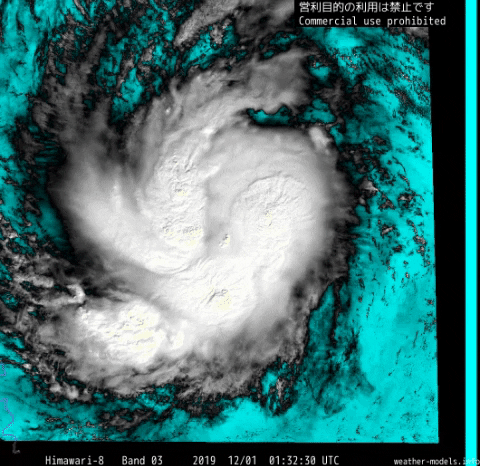
1900hurricane wrote:Reminds me of Dujuan '15 a bit when it first started to put itself together.
Also Koppu
1 likes
The posts in this forum are NOT official forecast and should not be used as such. They are just the opinion of the poster and may or may not be backed by sound meteorological data. They are NOT endorsed by any professional institution or storm2k.org. For official information, please refer to RSMC, NHC and NWS products.
Re: WPAC: KAMMURI - Typhoon
It still expects a rapid deepening... actually it initialized it as 78kt/943mb
0 likes
ヤンデレ女が寝取られるているのを見たい!!!
ECMWF ensemble NWPAC plots: https://ecmwfensnwpac.imgbb.com/
Multimodel NWPAC plots: https://multimodelnwpac.imgbb.com/
GFS Ensemble NWPAC plots (16 & 35 day forecast): https://gefsnwpac.imgbb.com/
Plots updated automatically
ECMWF ensemble NWPAC plots: https://ecmwfensnwpac.imgbb.com/
Multimodel NWPAC plots: https://multimodelnwpac.imgbb.com/
GFS Ensemble NWPAC plots (16 & 35 day forecast): https://gefsnwpac.imgbb.com/
Plots updated automatically
Re: WPAC: KAMMURI - Typhoon
2 likes
Very useful information on the Dvorak Technique --
https://severe.worldweather.wmo.int/TCF ... kBeven.pdf
Re: WPAC: KAMMURI - Typhoon
Exploded
0 likes
ヤンデレ女が寝取られるているのを見たい!!!
ECMWF ensemble NWPAC plots: https://ecmwfensnwpac.imgbb.com/
Multimodel NWPAC plots: https://multimodelnwpac.imgbb.com/
GFS Ensemble NWPAC plots (16 & 35 day forecast): https://gefsnwpac.imgbb.com/
Plots updated automatically
ECMWF ensemble NWPAC plots: https://ecmwfensnwpac.imgbb.com/
Multimodel NWPAC plots: https://multimodelnwpac.imgbb.com/
GFS Ensemble NWPAC plots (16 & 35 day forecast): https://gefsnwpac.imgbb.com/
Plots updated automatically
Re: WPAC: KAMMURI - Typhoon
Euro still agrees with HWRF (13z Monday) on intensity
0 likes
Very useful information on the Dvorak Technique --
https://severe.worldweather.wmo.int/TCF ... kBeven.pdf
Who is online
Users browsing this forum: No registered users and 6 guests