ATL: BARRY - Models
Moderator: S2k Moderators
-
gatorcane

- S2K Supporter

- Posts: 23708
- Age: 48
- Joined: Sun Mar 13, 2005 3:54 pm
- Location: Boca Raton, FL
Re: ATL: INVEST 92L - Models
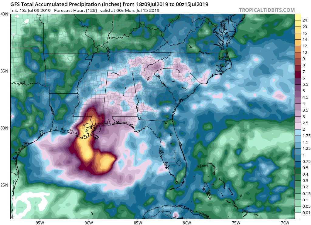
Wow that is a lot of rain for NOLA if the GFS is right 
Last edited by gatorcane on Tue Jul 09, 2019 7:59 pm, edited 1 time in total.
0 likes
-
TheStormExpert
Re: ATL: INVEST 92L - Models
It’ll be interesting to see what the 00z model suite shows but for now the consensus is not good for the New Orleans area in terms of flooding impacts.
1 likes
-
sphelps8681
- Category 2

- Posts: 785
- Joined: Thu Aug 16, 2007 5:37 pm
- Location: Somewhere over the rainbow
Re: ATL: INVEST 92L - Models
PTrackerLA wrote:I dont think I can share an image but the 18z Euro (out to 90 hrs only) shifted well to the west with a NNW heading about 100 or so miles south of Pecan Island, LA. Are the shorter intermediate runs of the Euro less reliable? First year I've seen this product.
Saw the same image with 979 headed to Tx/La border. Not sure how that will play out.
0 likes
-
MississippiWx

- S2K Supporter
- Posts: 1720
- Joined: Sat Aug 14, 2010 1:44 pm
- Location: Hattiesburg, Mississippi
Re: ATL: INVEST 92L - Models
Frank P wrote:MississippiWx wrote:This track situation is a doozy and far from set in stone. The 18z Euro just came in close to where the HWRF makes landfall, and thus stronger.
I didnt know there was a 18z Euro!
Yes, it's new this year. Not sure of its reliability compared to the normal cycles, but it is much farther to the west this run.
3 likes
This post is not an official forecast and should not be used as such. It is just the opinion of MississippiWx and may or may not be backed by sound meteorological data. It is not endorsed by any professional institution including storm2k.org. For Official Information please refer to the NHC and NWS products.
-
northjaxpro

- S2K Supporter
- Posts: 8900
- Joined: Mon Sep 27, 2010 11:21 am
- Location: Jacksonville, FL
Re: ATL: INVEST 92L - Models
TheStormExpert wrote:It’ll be interesting to see what the 00z model suite shows but for now the consensus is not good for the New Orleans area in terms of flooding impacts.
Exactly. I was just getting ready to mention this. Really that whole region of Louiisiana and Mississippi for that matter. Potential flood concerns in NOLA a very disticnt probability now.
Last edited by northjaxpro on Tue Jul 09, 2019 8:04 pm, edited 1 time in total.
0 likes
NEVER, EVER SAY NEVER in the tropics and weather in general, and most importantly, with life itself!!
________________________________________________________________________________________
Fay 2008 Beryl 2012 Debby 2012 Colin 2016 Hermine 2016 Julia 2016 Matthew 2016 Irma 2017 Dorian 2019
________________________________________________________________________________________
Fay 2008 Beryl 2012 Debby 2012 Colin 2016 Hermine 2016 Julia 2016 Matthew 2016 Irma 2017 Dorian 2019


Re: ATL: INVEST 92L - Models
So why the west shift in the Euro? That's concerning for SE Texas.....again.
0 likes
Personal Forecast Disclaimer:
The posts in this forum are NOT official forecast and should not be used as such. They are just the opinion of the poster and may or may not be backed by sound meteorological data. They are NOT endorsed by any professional institution or storm2k.org. For official information, please refer to the NHC and NWS products.
The posts in this forum are NOT official forecast and should not be used as such. They are just the opinion of the poster and may or may not be backed by sound meteorological data. They are NOT endorsed by any professional institution or storm2k.org. For official information, please refer to the NHC and NWS products.
-
gatorcane
- S2K Supporter
- Posts: 23708
- Age: 48
- Joined: Sun Mar 13, 2005 3:54 pm
- Location: Boca Raton, FL
Re: ATL: INVEST 92L - Models
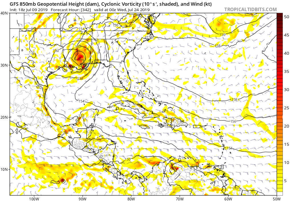
Wow looks like the GFS shows round 2 with future Barry making a large cyclonic loop (strengthening over land mind you lol) and coming back around for LA. 342 hours below:  this run is totally not believable.
Last edited by gatorcane on Tue Jul 09, 2019 8:09 pm, edited 1 time in total.
0 likes
-
LeonardRay
- Tropical Low

- Posts: 38
- Joined: Tue Aug 22, 2017 3:24 pm
Re: ATL: INVEST 92L - Models
PTrackerLA wrote:I dont think I can share an image but the 18z Euro (out to 90 hrs only) shifted well to the west with a NNW heading about 100 or so miles south of Pecan Island, LA. Are the shorter intermediate runs of the Euro less reliable? First year I've seen this product.
Where can I run the 18z euro?
0 likes
-
northjaxpro
- S2K Supporter
- Posts: 8900
- Joined: Mon Sep 27, 2010 11:21 am
- Location: Jacksonville, FL
Re: ATL: INVEST 92L - Models
gatorcane wrote:Wow looks like the GFS shows round 2 with future Barry making a large cyclonic loop (strengthening over land mind you lol) and coming back around for LA. 342 hours below:
https://i.postimg.cc/CMnTZk6X/gfs-z850-vort-watl-58.png
I do not want to even think about this crazy long range solution right now. Thankfully it is LONG RANGE! Let us get through this week's situation first and foremost, which is keeping me and everyone else very busy.
Last edited by northjaxpro on Tue Jul 09, 2019 8:13 pm, edited 3 times in total.
1 likes
NEVER, EVER SAY NEVER in the tropics and weather in general, and most importantly, with life itself!!
________________________________________________________________________________________
Fay 2008 Beryl 2012 Debby 2012 Colin 2016 Hermine 2016 Julia 2016 Matthew 2016 Irma 2017 Dorian 2019
________________________________________________________________________________________
Fay 2008 Beryl 2012 Debby 2012 Colin 2016 Hermine 2016 Julia 2016 Matthew 2016 Irma 2017 Dorian 2019


-
jasons2k

- Storm2k Executive

- Posts: 8290
- Age: 52
- Joined: Wed Jul 06, 2005 12:32 pm
- Location: The Woodlands, TX
Re: ATL: INVEST 92L - Models
gatorcane wrote:Wow looks like the GFS shows round 2 with future Barry making a large cyclonic loop (strengthening over land mind you lol) and coming back around for LA. 342 hours below:
It is early July. It's quite possible for a ridge to build back in. Wouldn't be the first time.
1 likes
-
CaneCurious

- Tropical Storm

- Posts: 160
- Joined: Wed Aug 25, 2004 1:40 pm
- Location: Kenner, LA
Re: ATL: INVEST 92L - Models
gatorcane wrote:Wow that is a lot of rain for NOLA if the GFS is right
https://i.postimg.cc/Y0M9SRzc/gfs-apcpn-seus-21.png
We can’t handle that much rain! Parts of the city will be decimated by that much water.
0 likes
-
South Texas Storms

- Professional-Met

- Posts: 4256
- Joined: Thu Jun 24, 2010 12:28 am
- Location: Houston, TX
Re: ATL: INVEST 92L - Models
NDG wrote:18z Rapid HD Euro will definitely wake up Houston people again
https://i.imgur.com/38UtB0E
No one over here should be sleeping yet anyway! Like I mentioned this afternoon, everywhere from TX to MS shouldn't let their guard down just because most of today's models started to key in on LA being the likely landfall spot. Still far from a sure thing.
6 likes
Re: ATL: INVEST 92L - Models
South Texas Storms wrote:NDG wrote:18z Rapid HD Euro will definitely wake up Houston people again
https://i.imgur.com/38UtB0E
No one over here should be sleeping yet anyway! Like I mentioned this afternoon, everywhere from TX to MS shouldn't let their guard down just because most of today's models started to key in on LA being the likely landfall spot. Still far from a sure thing.
But what is it picking up on that changes so dramatically from the last 2 runs?
0 likes
Personal Forecast Disclaimer:
The posts in this forum are NOT official forecast and should not be used as such. They are just the opinion of the poster and may or may not be backed by sound meteorological data. They are NOT endorsed by any professional institution or storm2k.org. For official information, please refer to the NHC and NWS products.
The posts in this forum are NOT official forecast and should not be used as such. They are just the opinion of the poster and may or may not be backed by sound meteorological data. They are NOT endorsed by any professional institution or storm2k.org. For official information, please refer to the NHC and NWS products.
-
LeonardRay
- Tropical Low
- Posts: 38
- Joined: Tue Aug 22, 2017 3:24 pm
Re: RE: Re: ATL: INVEST 92L - Models
I'm sure it missed the trough and the high started to build back in and a deeper system will react to that with a more westward movement.SoupBone wrote:South Texas Storms wrote:NDG wrote:18z Rapid HD Euro will definitely wake up Houston people again
https://i.imgur.com/38UtB0E
No one over here should be sleeping yet anyway! Like I mentioned this afternoon, everywhere from TX to MS shouldn't let their guard down just because most of today's models started to key in on LA being the likely landfall spot. Still far from a sure thing.
But what is it picking up on that changes so dramatically from the last 2 runs?
Sent from my EVR-L29 using Tapatalk
1 likes
Re: ATL: INVEST 92L - Models
SoupBone wrote:South Texas Storms wrote:NDG wrote:18z Rapid HD Euro will definitely wake up Houston people again
https://i.imgur.com/38UtB0E
No one over here should be sleeping yet anyway! Like I mentioned this afternoon, everywhere from TX to MS shouldn't let their guard down just because most of today's models started to key in on LA being the likely landfall spot. Still far from a sure thing.
But what is it picking up on that changes so dramatically from the last 2 runs?
Like Levi explained a stronger hurricane would track further west, in this case this is what the HWRF and 18z Rapid Euro do.
1 likes
-
Camerooski
- Tropical Low
- Posts: 47
- Joined: Wed Aug 08, 2018 5:40 pm
- Location: Lauderdale-By-the-Sea ---> Coral Gables
Re: ATL: INVEST 92L - Models
SoupBone wrote:South Texas Storms wrote:NDG wrote:18z Rapid HD Euro will definitely wake up Houston people again
https://i.imgur.com/38UtB0E
No one over here should be sleeping yet anyway! Like I mentioned this afternoon, everywhere from TX to MS shouldn't let their guard down just because most of today's models started to key in on LA being the likely landfall spot. Still far from a sure thing.
But what is it picking up on that changes so dramatically from the last 2 runs?
The stronger the storm the higher in the atmosphere it will feel the affects of the northerly flow pushing the storm to the south and west. Therefore, the stronger Barry is the further west, the weaker= eastern solution.
3 likes
-
plasticup
Re: ATL: INVEST 92L - Models: First runs from HWRF / HMON are up
northjaxpro wrote:toad strangler wrote:The HWRF is laughably always over done IMO
HWRF nailed Hurricane Danny in 2015, which underwent rapid intensification into a major hurricane in the Tropical Atlant:ic . It was the only model which had it as a major hurricane.
Don't be so hard on that model....
Broken clock, twice a day, etc
1 likes
Who is online
Users browsing this forum: No registered users and 21 guests