ATL: DORIAN - Models
Moderator: S2k Moderators
-
PavelGaborik10
- Category 1

- Posts: 472
- Joined: Tue Sep 04, 2018 3:23 pm
Re: ATL: DORIAN - Models
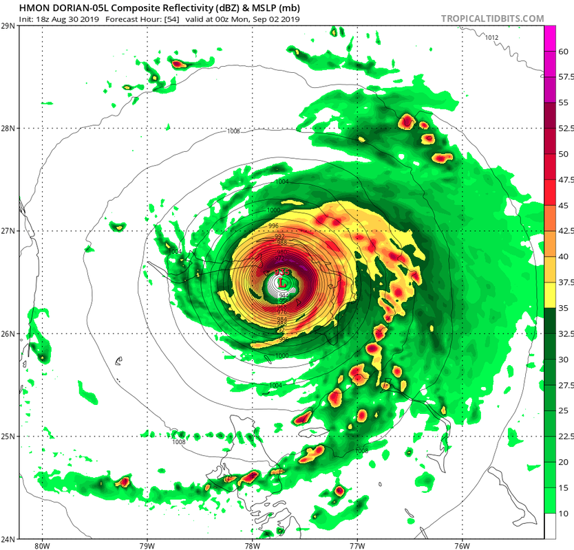
18z HMON is noticeably faster at hour 33. Hits Abaco Midday Sunday with a cat 5 8 hours sooner than the 12z did.
Last edited by BobHarlem on Fri Aug 30, 2019 5:53 pm, edited 1 time in total.
0 likes
-
gatorcane

- S2K Supporter

- Posts: 23708
- Age: 48
- Joined: Sun Mar 13, 2005 3:54 pm
- Location: Boca Raton, FL
Re: ATL: DORIAN - Models
That SW wobble on the 18Z GFS is a bit concerning. Plus the run is more south of the 12Z on its approach to SE Florida. If it shifts south just a bit more and the SW dip is a bit more pronounced, it could come ashore Palm Beach County. ICON/HMON/NAM insist on a SW dip. Perhaps because they depict a more intense cyclone being steered by 300MB. Timeframe is around 4 days so still plenty of room for shifts.
Last edited by gatorcane on Fri Aug 30, 2019 5:55 pm, edited 4 times in total.
5 likes

Re: ATL: DORIAN - Models
HurricaneFrances04 wrote:HMON coming in further NW through 24 hours.
It is a little north of where it was on the 12z run, though still south of most of the other runs at 48hrs.
ICON also has moved further north relative to where it was by 48hrs compared to the 12z run, though still has a pretty impressive WSW/SW dive. Can't rule it out given how it nailed the eastward stint earlier in Dorian's track.
Last edited by KWT on Fri Aug 30, 2019 5:54 pm, edited 1 time in total.
0 likes
Personal Forecast Disclaimer:
The posts in this forum are NOT official forecast and should not be used as such. They are just the opinion of the poster and may or may not be backed by sound meteorological data. They are NOT endorsed by any professional institution or storm2k.org. For official information, please refer to the NHC and NWS products
The posts in this forum are NOT official forecast and should not be used as such. They are just the opinion of the poster and may or may not be backed by sound meteorological data. They are NOT endorsed by any professional institution or storm2k.org. For official information, please refer to the NHC and NWS products

Re: ATL: DORIAN - Models
shiny-pebble wrote:Could the models not initializing Dorian strong enough affect their projected path?
Sent from my LG-H700 using Tapatalk
I'm not a Pro or anyone with any meteorological classes, but if I remember correctly from past storms, they do have some effect on the projected path.
0 likes
Personal Forecast Disclaimer:
The posts in this forum are NOT official forecast and should not be used as such. They are just the opinion of the poster and may or may not be backed by sound meteorological data. They are NOT endorsed by any professional institution or storm2k.org. For official information, please refer to the NHC and NWS products.
The posts in this forum are NOT official forecast and should not be used as such. They are just the opinion of the poster and may or may not be backed by sound meteorological data. They are NOT endorsed by any professional institution or storm2k.org. For official information, please refer to the NHC and NWS products.
-
Aric Dunn
- Category 5

- Posts: 21238
- Age: 43
- Joined: Sun Sep 19, 2004 9:58 pm
- Location: Ready for the Chase.
- Contact:
Re: ATL: DORIAN - Models
HMON is wsw from 48 to 54 hrs so far.
0 likes
Note: If I make a post that is brief. Please refer back to previous posts for the analysis or reasoning. I do not re-write/qoute what my initial post said each time.
If there is nothing before... then just ask
Space & Atmospheric Physicist, Embry-Riddle Aeronautical University,
I believe the sky is falling...
If there is nothing before... then just ask
Space & Atmospheric Physicist, Embry-Riddle Aeronautical University,
I believe the sky is falling...
-
AubreyStorm

- Category 1
- Posts: 337
- Age: 45
- Joined: Fri Jun 16, 2017 6:21 pm
- Location: Texas, USA
Re: ATL: DORIAN - Models
BobHarlem wrote:18z HMON is noticeably faster at hour 33. Hits Abaco Midday Sunday with a cat 5 8 hours sooner than the 12z did.
Picture? WOW!
0 likes
The posts are NOT an official forecast. Please REFER to the NHC and NWS for official forecasts and products.
-
Aric Dunn
- Category 5
- Posts: 21238
- Age: 43
- Joined: Sun Sep 19, 2004 9:58 pm
- Location: Ready for the Chase.
- Contact:
Re: ATL: DORIAN - Models
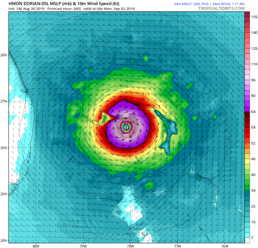
HMON 60 hours
note: this is just random postion along the track. not all are included..

note: this is just random postion along the track. not all are included..
Last edited by Aric Dunn on Fri Aug 30, 2019 6:05 pm, edited 1 time in total.
1 likes
Note: If I make a post that is brief. Please refer back to previous posts for the analysis or reasoning. I do not re-write/qoute what my initial post said each time.
If there is nothing before... then just ask
Space & Atmospheric Physicist, Embry-Riddle Aeronautical University,
I believe the sky is falling...
If there is nothing before... then just ask
Space & Atmospheric Physicist, Embry-Riddle Aeronautical University,
I believe the sky is falling...
-
AubreyStorm
- Category 1
- Posts: 337
- Age: 45
- Joined: Fri Jun 16, 2017 6:21 pm
- Location: Texas, USA
Re: ATL: DORIAN - Models
gatorcane wrote:gatorcane wrote:18Z HMON moving WSW just south of Grand Bahama
https://i.postimg.cc/MG7GwLf5/hmon-mslp-wind-05-L-21.png
Cat 5.... OMGGGGGGGGGGG
0 likes
The posts are NOT an official forecast. Please REFER to the NHC and NWS for official forecasts and products.
Re: ATL: DORIAN - Models
Aric Dunn wrote:HMON is wsw from 48 to 54 hrs so far.
Both HMON and ICON are pretty stubbornly sticking to this WSW motion. I think tomorrows motion will give us a good clue of whether this is ever going to be realistic and just how westerly the motion is.
NAM 3km also heads WSW fwiw.
Last edited by KWT on Fri Aug 30, 2019 6:08 pm, edited 1 time in total.
2 likes
Personal Forecast Disclaimer:
The posts in this forum are NOT official forecast and should not be used as such. They are just the opinion of the poster and may or may not be backed by sound meteorological data. They are NOT endorsed by any professional institution or storm2k.org. For official information, please refer to the NHC and NWS products
The posts in this forum are NOT official forecast and should not be used as such. They are just the opinion of the poster and may or may not be backed by sound meteorological data. They are NOT endorsed by any professional institution or storm2k.org. For official information, please refer to the NHC and NWS products
-
gatorcane
- S2K Supporter
- Posts: 23708
- Age: 48
- Joined: Sun Mar 13, 2005 3:54 pm
- Location: Boca Raton, FL
Re: ATL: DORIAN - Models
KWT wrote:Aric Dunn wrote:HMON is wsw from 48 to 54 hrs so far.
Both HMON and ICON are pretty stubbornly sticking to this WSW motion. I think tomorrows motion will give us a good clue of whether this is ever going to be realistic and just how westerly the motion is.
Maybe because those models show CAT 5s and are steered by 300MB?
4 likes

Re: ATL: DORIAN - Models
Just saw a few posts in the discussion thread about the latest recon measuring 946/947 mbar. Is it normal for an intensifying hurricane like this to be so much stronger than many of the global models are at 0 hours?
Last edited by kevin on Fri Aug 30, 2019 6:12 pm, edited 1 time in total.
1 likes
-
AdamFirst

- S2K Supporter
- Posts: 2490
- Age: 36
- Joined: Thu Aug 14, 2008 10:54 am
- Location: Port Saint Lucie, FL
Re: ATL: DORIAN - Models
HWRF going bonkers on intensity
150 knots at 48 hours east of Abaco
150 knots at 48 hours east of Abaco
0 likes
Dolphins Marlins Canes Golden Panthers HEAT
Andrew 1992 - Irene 1999 - Frances 2004 - Jeanne 2004 - Wilma 2005 - Fay 2008 - Isaac 2012 - Matthew 2016 - Irma 2017 - Dorian 2019 - Ian 2022 - Nicole 2022 - Milton 2024
Andrew 1992 - Irene 1999 - Frances 2004 - Jeanne 2004 - Wilma 2005 - Fay 2008 - Isaac 2012 - Matthew 2016 - Irma 2017 - Dorian 2019 - Ian 2022 - Nicole 2022 - Milton 2024
-
supercane4867
- Category 5
- Posts: 4966
- Joined: Wed Nov 14, 2012 10:43 am
Re: ATL: DORIAN - Models
The City of Freeport in the Bahamas would be wiped clean if HMON verifies...
0 likes

Re: ATL: DORIAN - Models
gatorcane wrote:HMON with a small loop at 72 hours
The stall indicates lack of steering at all levels.
0 likes
-
orion

- S2K Supporter
- Posts: 165
- Joined: Mon Aug 02, 2004 5:44 pm
- Location: Indian Harbour Beach, FL
- Contact:
Re: ATL: DORIAN - Models
Orlando wrote:Could someone with professional knowledge explain to us exactly how the models know how and what to predict? Someone mentioned earlier something about atmospheric machines regarding model predictions. What exactly are those and how do they work?
For more info and explanation on ensemble prediction systems, this is a pretty good site from NCEP:
https://www.wpc.ncep.noaa.gov/ensembletraining/
3 likes
~Jeff
@meteoJeff
Meteorologist/Sr Technical Advisor at US Air Force
Patrick Space Force Base, FL
24th Analysis Squadron/Environmental Modeling and Simulation (EMS)
PhD in Meteorology, Florida Institute of Technology 2018
@meteoJeff
Meteorologist/Sr Technical Advisor at US Air Force
Patrick Space Force Base, FL
24th Analysis Squadron/Environmental Modeling and Simulation (EMS)
PhD in Meteorology, Florida Institute of Technology 2018
Who is online
Users browsing this forum: No registered users and 74 guests