ATL: DORIAN - Models

Moderator: S2k Moderators

Message
Author
User avatar
KWT
Category 5
Category 5
Posts: 31415
Joined: Tue Aug 17, 2004 11:02 am
Location: UK!!!

Re: ATL: DORIAN - Models

#4181 Postby KWT » Fri Aug 30, 2019 6:16 pm

gatorcane wrote:HMON with a small loop at 72 hours


loop maybe suggestive of it about to launch NW and join the other models on their northward jaunt offshore, but we will see. Some serious damage on the Bahamas though from a 4/5....
0 likes   
Personal Forecast Disclaimer:
The posts in this forum are NOT official forecast and should not be used as such. They are just the opinion of the poster and may or may not be backed by sound meteorological data. They are NOT endorsed by any professional institution or storm2k.org. For official information, please refer to the NHC and NWS products

User avatar
cjrciadt
S2K Supporter
S2K Supporter
Posts: 1616
Joined: Mon Aug 22, 2005 1:11 pm
Location: Kissimmee, FL

Re: ATL: DORIAN - Models

#4182 Postby cjrciadt » Fri Aug 30, 2019 6:16 pm

AdamFirst wrote:HWRF going bonkers on intensity
150 knots at 48 hours east of Abaco

It might be behind which is even more bonkers!! :x
0 likes   

User avatar
gatorcane
S2K Supporter
S2K Supporter
Posts: 23692
Age: 47
Joined: Sun Mar 13, 2005 3:54 pm
Location: Boca Raton, FL

Re: ATL: DORIAN - Models

#4183 Postby gatorcane » Fri Aug 30, 2019 6:17 pm

HMON resumes SW movement... :eek:

Image
0 likes   

User avatar
AubreyStorm
Category 1
Category 1
Posts: 337
Age: 44
Joined: Fri Jun 16, 2017 6:21 pm
Location: Texas, USA

Re: ATL: DORIAN - Models

#4184 Postby AubreyStorm » Fri Aug 30, 2019 6:17 pm

cjrciadt wrote:
AdamFirst wrote:HWRF going bonkers on intensity
150 knots at 48 hours east of Abaco

It might be behind which is even more bonkers!! :x


Link HWRF? Please :lol:
0 likes   
The posts are NOT an official forecast. Please REFER to the NHC and NWS for official forecasts and products.

supercane4867
Category 5
Category 5
Posts: 4966
Joined: Wed Nov 14, 2012 10:43 am

Re: ATL: DORIAN - Models

#4185 Postby supercane4867 » Fri Aug 30, 2019 6:19 pm

The stalling on HMON may indicates that it misses the first weakeness and steers westward
0 likes   

User avatar
SFLcane
S2K Supporter
S2K Supporter
Posts: 10163
Age: 47
Joined: Sat Jun 05, 2010 1:44 pm
Location: Lake Worth Florida

Re: ATL: DORIAN - Models

#4186 Postby SFLcane » Fri Aug 30, 2019 6:21 pm

Woah Hmon! Right of SFL coast at 84rs..
0 likes   

User avatar
La Sirena
Category 1
Category 1
Posts: 307
Joined: Sun Aug 21, 2016 4:02 pm
Location: Formerly of the Keys, back home in East TN

Re: ATL: DORIAN - Models

#4187 Postby La Sirena » Fri Aug 30, 2019 6:22 pm

AubreyStorm wrote:
cjrciadt wrote:
AdamFirst wrote:HWRF going bonkers on intensity
150 knots at 48 hours east of Abaco

It might be behind which is even more bonkers!! :x


Link HWRF? Please :lol:

https://www.tropicaltidbits.com/analysi ... 83018&fh=6

Bookmark as it has the majority of models.
0 likes   
The posts in this forum are NOT official forecasts and should not be used as such. They are just the opinion of the poster and may or may not be backed by sound meteorological data. They are NOT endorsed by any professional institution or STORM2K. For official information, please refer to products from the NHC and NWS.

User avatar
KWT
Category 5
Category 5
Posts: 31415
Joined: Tue Aug 17, 2004 11:02 am
Location: UK!!!

Re: ATL: DORIAN - Models

#4188 Postby KWT » Fri Aug 30, 2019 6:22 pm

HMON big jog NNW at 90hrs, not sure if its a wobble of whether its about to picked up by the weakness as per most other runs.
0 likes   
Personal Forecast Disclaimer:
The posts in this forum are NOT official forecast and should not be used as such. They are just the opinion of the poster and may or may not be backed by sound meteorological data. They are NOT endorsed by any professional institution or storm2k.org. For official information, please refer to the NHC and NWS products

User avatar
AubreyStorm
Category 1
Category 1
Posts: 337
Age: 44
Joined: Fri Jun 16, 2017 6:21 pm
Location: Texas, USA

Re: ATL: DORIAN - Models

#4189 Postby AubreyStorm » Fri Aug 30, 2019 6:22 pm

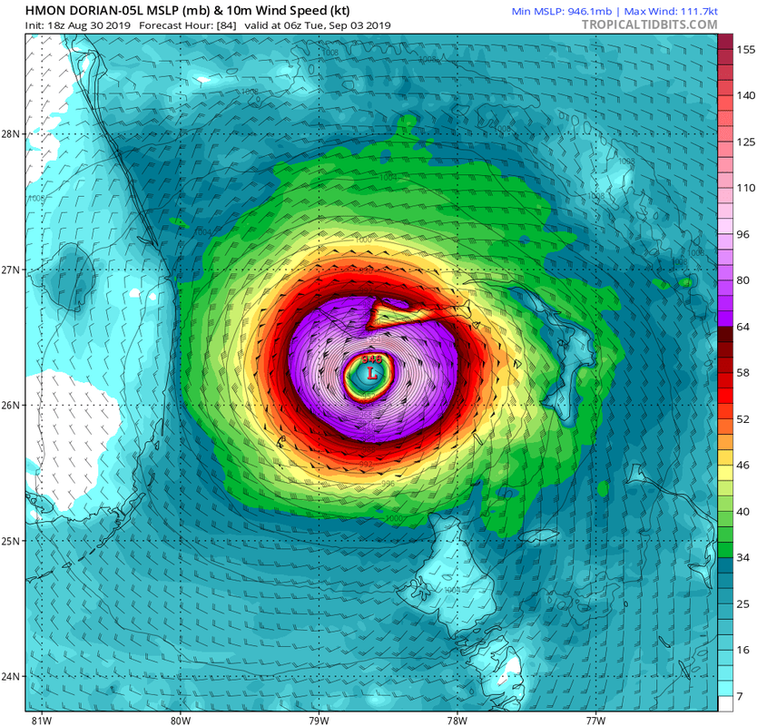
SFLcane wrote:Woah Hmon! Right of SFL coast at 84rs..


Link please ...
0 likes   
The posts are NOT an official forecast. Please REFER to the NHC and NWS for official forecasts and products.

BobHarlem
Category 5
Category 5
Posts: 2133
Joined: Thu Oct 20, 2005 6:11 pm

Re: ATL: DORIAN - Models

#4190 Postby BobHarlem » Fri Aug 30, 2019 6:23 pm

Grand Bahama getting 36 hours of Northern Eyewall of a cat 4/5 storm... 18 hmon.
0 likes   

Aric Dunn
Category 5
Category 5
Posts: 21238
Age: 42
Joined: Sun Sep 19, 2004 9:58 pm
Location: Ready for the Chase.
Contact:

Re: ATL: DORIAN - Models

#4191 Postby Aric Dunn » Fri Aug 30, 2019 6:24 pm

now that is a real stall.. from the HMON
0 likes   
Note: If I make a post that is brief. Please refer back to previous posts for the analysis or reasoning. I do not re-write/qoute what my initial post said each time.
If there is nothing before... then just ask :)

Space & Atmospheric Physicist, Embry-Riddle Aeronautical University,
I believe the sky is falling...

Aric Dunn
Category 5
Category 5
Posts: 21238
Age: 42
Joined: Sun Sep 19, 2004 9:58 pm
Location: Ready for the Chase.
Contact:

Re: ATL: DORIAN - Models

#4192 Postby Aric Dunn » Fri Aug 30, 2019 6:26 pm

HMON north and NE ... out to sea..
2 likes   
Note: If I make a post that is brief. Please refer back to previous posts for the analysis or reasoning. I do not re-write/qoute what my initial post said each time.
If there is nothing before... then just ask :)

Space & Atmospheric Physicist, Embry-Riddle Aeronautical University,
I believe the sky is falling...

User avatar
got ants?
Tropical Storm
Tropical Storm
Posts: 114
Age: 66
Joined: Sat Sep 03, 2011 3:44 am
Location: Hollywood/Ft Laud

Re: ATL: DORIAN - Models

#4193 Postby got ants? » Fri Aug 30, 2019 6:26 pm

Can anyone explain to me the modeling that WU is using to have Dorian mark a hard turn, NNW after lanfall? An hour ago they had Dorian leaving land, just after landfall, but now riding up I 95 for 100 miles?
0 likes   
This post is NOT AN OFFICIAL FORECAST and should not be used as such. It is just the opinion of the poster and may or may not be backed by sound meteorological data. It is NOT endorsed by any professional institution including storm2k.org. For Official Information please refer to the NHC and NWS products.

User avatar
KWT
Category 5
Category 5
Posts: 31415
Joined: Tue Aug 17, 2004 11:02 am
Location: UK!!!

Re: ATL: DORIAN - Models

#4194 Postby KWT » Fri Aug 30, 2019 6:26 pm

HMON near due north between 90-99hrs, lifting out and beginning the recurve solution...

So just ICON on its own now...
1 likes   
Personal Forecast Disclaimer:
The posts in this forum are NOT official forecast and should not be used as such. They are just the opinion of the poster and may or may not be backed by sound meteorological data. They are NOT endorsed by any professional institution or storm2k.org. For official information, please refer to the NHC and NWS products

supercane4867
Category 5
Category 5
Posts: 4966
Joined: Wed Nov 14, 2012 10:43 am

Re: ATL: DORIAN - Models

#4195 Postby supercane4867 » Fri Aug 30, 2019 6:26 pm

Both HWRF and HMON likely OTS
0 likes   

User avatar
got ants?
Tropical Storm
Tropical Storm
Posts: 114
Age: 66
Joined: Sat Sep 03, 2011 3:44 am
Location: Hollywood/Ft Laud

Re: ATL: DORIAN - Models

#4196 Postby got ants? » Fri Aug 30, 2019 6:27 pm

btw, talking about thier app (Weather Underground)
0 likes   
This post is NOT AN OFFICIAL FORECAST and should not be used as such. It is just the opinion of the poster and may or may not be backed by sound meteorological data. It is NOT endorsed by any professional institution including storm2k.org. For Official Information please refer to the NHC and NWS products.

User avatar
SFLcane
S2K Supporter
S2K Supporter
Posts: 10163
Age: 47
Joined: Sat Jun 05, 2010 1:44 pm
Location: Lake Worth Florida

Re: ATL: DORIAN - Models

#4197 Postby SFLcane » Fri Aug 30, 2019 6:27 pm

Image
0 likes   

WeatherEmperor
S2K Supporter
S2K Supporter
Posts: 4806
Age: 41
Joined: Thu Sep 04, 2003 2:54 pm
Location: South Florida

Re: ATL: DORIAN - Models

#4198 Postby WeatherEmperor » Fri Aug 30, 2019 6:31 pm

The HMON is not only trying to retire the name “Dorian” but also is pushing for legislation that if anybody gets caught saying its name in public to be punishable with life in prison without the possibility of parole


Sent from my iPhone using Tapatalk
3 likes   

supercane4867
Category 5
Category 5
Posts: 4966
Joined: Wed Nov 14, 2012 10:43 am

Re: ATL: DORIAN - Models

#4199 Postby supercane4867 » Fri Aug 30, 2019 6:31 pm

HMON basically has the hurricane falling apart while moving NW at 102hr. I call this BS
1 likes   

beachman80

Re: ATL: DORIAN - Models

#4200 Postby beachman80 » Fri Aug 30, 2019 6:33 pm

HMON jumps on board of the north turn and missing Fla.
0 likes   


Return to “2019”

Who is online

Users browsing this forum: No registered users and 12 guests