ATL: DORIAN - Models

Moderator: S2k Moderators

Message
Author
NFLnut
Category 2
Category 2
Posts: 541
Joined: Sun Aug 29, 2004 7:37 pm

Re: ATL: DORIAN - Models

#4301 Postby NFLnut » Fri Aug 30, 2019 8:27 pm

supercane4867 wrote:
Ken711 wrote:
supercane4867 wrote:Dorian is no Floyd. The setup is completely different


Matthew?

More like Frances if I have to pick one. Just maybe further east


Frances entered Florida around Brevard county and moved northwest across the entire state, exiting into the GOM. Are you sure you meant Frances?
0 likes   

tolakram
Admin
Admin
Posts: 20012
Age: 62
Joined: Sun Aug 27, 2006 8:23 pm
Location: Florence, KY (name is Mark)

Re: ATL: DORIAN - Models

#4302 Postby tolakram » Fri Aug 30, 2019 8:28 pm

Latest error plot. Focus on the kilometer error at 96 hours. Best model is 190 km, euro is 310.

There should be NO surprises if Dorian doesn't go where you think it will. The only way to reduce the error is to get closer to landfall.

Image

source: http://www.atmos.albany.edu/facstaff/tang/tcguidance/al052019/
8 likes   
M a r k
- - - - -
Join us in chat: Storm2K Chatroom Invite. Android and IOS apps also available.

The posts in this forum are NOT official forecasts and should not be used as such. Posts are NOT endorsed by any professional institution or STORM2K.org. For official information and forecasts, please refer to NHC and NWS products.

User avatar
SEASON_CANCELED
Category 3
Category 3
Posts: 887
Joined: Mon Jul 06, 2009 5:17 am
Location: 8 Bit Charlie Sheen

Re: ATL: DORIAN - Models

#4303 Postby SEASON_CANCELED » Fri Aug 30, 2019 8:28 pm

AutoPenalti wrote:Guys note that we are still roughly 72 hours before any sort of landfall, things can change just as quickly as today.


Best post in the thread.

At this time Irma was forceast to scrap the florida east coast.

Of course the models we're 100 miles off

Do not let your guard down
5 likes   
i am a big stupid ugly moron with an ugly face and a big butt and my butt stinks and i like to kiss my own butt

User avatar
ConvergenceZone
Category 5
Category 5
Posts: 5194
Joined: Fri Jul 29, 2005 1:40 am
Location: Northern California

Re: ATL: DORIAN - Models

#4304 Postby ConvergenceZone » Fri Aug 30, 2019 8:29 pm

otowntiger wrote:
Ken711 wrote:
supercane4867 wrote:Dorian is no Floyd. The setup is completely different


Matthew?

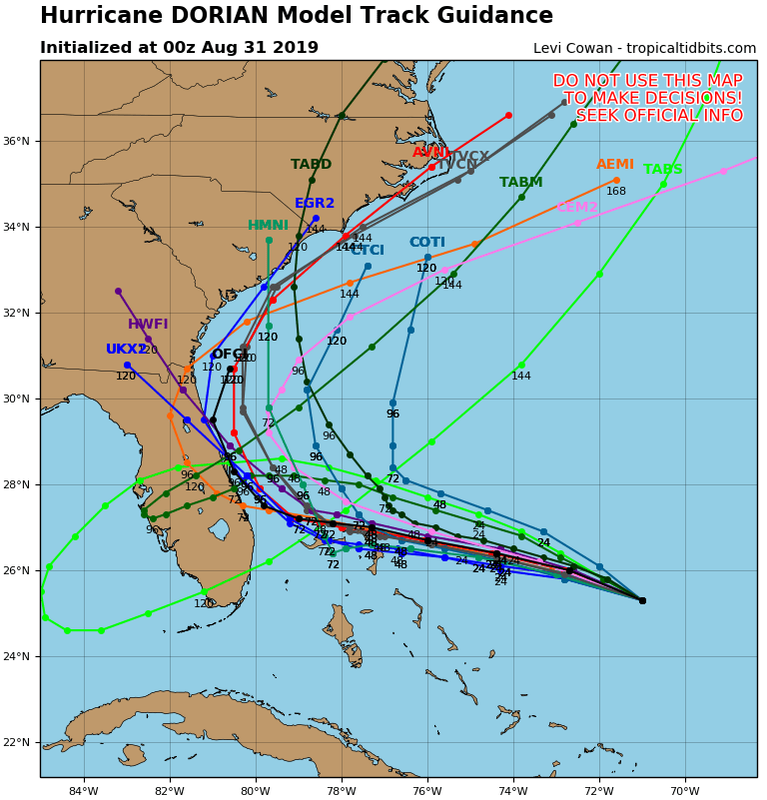
I don’t think it will get as close as Matthew. The next NHC advisory will almost certainly be offshore and I believe the shifts east will continue. Just my opinion. It seems climatology and current Synoptics combined are pointing to a much better track for all of us in Florida. I for one am feeling much better tonight.


I agree! Although there is still an outside chance this storm will still hit Florida, it's looking better and better with each passing model run, and you can now officially say that all of the models are now trending east....The best case is that they continue to trend east and not only miss Florida, but also miss the islands as well, but not sure it will be able to get North of the islands or not. But yes, feeling much much much better than this last night and even much better than this afternoon...........

I think everyone is feeling better, hence the slow amount of posting on this board compared to 24 hours ago....
Last edited by ConvergenceZone on Fri Aug 30, 2019 8:32 pm, edited 1 time in total.
1 likes   

User avatar
NDG
S2K Supporter
S2K Supporter
Posts: 15446
Joined: Sun Jul 09, 2006 10:14 pm
Location: Orlando, FL

Re: ATL: DORIAN - Models

#4305 Postby NDG » Fri Aug 30, 2019 8:29 pm

Blown Away wrote:
gatorcane wrote:Amazing model swings just 4 days out. Check out the 00Z tracks. Night and day from 24 hours ago. IN fact TVCN recurves with no US landfall:

https://i.postimg.cc/T3PFtpnf/05-L-tracks-00z.png


And TVCN goes N of the Bahamas... Might be a total miss... Wow amazing swing...


Still brings the eyewall to the extreme northern Bahamas.

Image
0 likes   

boulderrr
Tropical Depression
Tropical Depression
Posts: 55
Joined: Mon Aug 22, 2016 11:30 am
Location: Nederland, Colorado - 8,500'

Re: ATL: DORIAN - Models

#4306 Postby boulderrr » Fri Aug 30, 2019 8:33 pm

Image

Does anyone know where the OFCL plot came from for this? It shows Dorian remaining offshore and bending NE toward hour 120, which the latest NHC forecast does not show.
0 likes   

User avatar
Blinhart
Category 5
Category 5
Posts: 2081
Age: 48
Joined: Thu Sep 08, 2011 3:13 pm
Location: Crowley, La.

Re: ATL: DORIAN - Models

#4307 Postby Blinhart » Fri Aug 30, 2019 8:38 pm

Everyone also has to remember that all these models that are running now or in the past 3 hours do not have the most current information about strength and pressure, so you got to take them with a grain of salt.

I really think this will end up going further South and West than all these models are showing, I think the ICON will be more in line than what we all thought. Maybe the German Model will get it correct...
3 likes   
Personal Forecast Disclaimer:
The posts in this forum are NOT official forecast and should not be used as such. They are just the opinion of the poster and may or may not be backed by sound meteorological data. They are NOT endorsed by any professional institution or storm2k.org. For official information, please refer to the NHC and NWS products.

User avatar
fci
S2K Supporter
S2K Supporter
Posts: 3324
Joined: Tue Sep 14, 2004 10:29 am
Location: Lake Worth, FL

Re: ATL: DORIAN - Models

#4308 Postby fci » Fri Aug 30, 2019 8:40 pm

AutoPenalti wrote:Guys note that we are still roughly 72 hours before any sort of landfall, things can change just as quickly as today.


The trend is your friend!!
0 likes   
Personal Forecast Disclaimer:
My posts are just my opinion and are most likely not backed by sound meteorological data. They are NOT endorsed by any professional institution or storm2k.org. For official information, please refer to the NHC and NWS products.
Bottom line is that I am just expressing my opinion!!!

BobHarlem
Category 5
Category 5
Posts: 2131
Joined: Thu Oct 20, 2005 6:11 pm

Re: ATL: DORIAN - Models

#4309 Postby BobHarlem » Fri Aug 30, 2019 8:42 pm

Wrong thread. But I'd caution with the RI that's happening tonight to really buy any of the models. Florida isn't an outside chance, it's more like 50/50.
1 likes   

User avatar
Nimbus
Category 5
Category 5
Posts: 5306
Joined: Mon Jul 19, 2004 10:54 am

Re: ATL: DORIAN - Models

#4310 Postby Nimbus » Fri Aug 30, 2019 8:43 pm

boca wrote:Yes the steering currents will collapse and just be drifting north due to weak currents off our coast.


According to Levi Cohen the stall is partially due to the top of a high pressure circulation in the gulf pushing ESE at the ~300 mb level. The trough to the north of that high apparently misses. So its going to be critical for Dorian to keep gaining latitude and get north of 26N.
Trough could dig more than forecast which would simplify the solution and add a lot of confidence to the recurve scenario, but its still a few days out yet.
1 likes   

User avatar
gatorcane
S2K Supporter
S2K Supporter
Posts: 23691
Age: 47
Joined: Sun Mar 13, 2005 3:54 pm
Location: Boca Raton, FL

Re: ATL: DORIAN - Models

#4311 Postby gatorcane » Fri Aug 30, 2019 8:48 pm

Can somebody post the 12Z UKMET ensembles? Levi showed them and I was surprised how many were into SE Florida.
1 likes   

User avatar
NDG
S2K Supporter
S2K Supporter
Posts: 15446
Joined: Sun Jul 09, 2006 10:14 pm
Location: Orlando, FL

Re: ATL: DORIAN - Models

#4312 Postby NDG » Fri Aug 30, 2019 8:51 pm

AutoPenalti wrote:Guys note that we are still roughly 72 hours before any sort of landfall, things can change just as quickly as today.


More like 84-96 hrs.
0 likes   

BobHarlem
Category 5
Category 5
Posts: 2131
Joined: Thu Oct 20, 2005 6:11 pm

Re: ATL: DORIAN - Models

#4313 Postby BobHarlem » Fri Aug 30, 2019 8:52 pm

gatorcane wrote:Can somebody post the 12Z UKMET ensembles? Levi showed them and I was surprised how many were into SE Florida.


Image

from: https://ruc.noaa.gov/hfip/tceps/tceps.php?model=ukmo
2 likes   

MrJames
Tropical Storm
Tropical Storm
Posts: 189
Joined: Fri Sep 10, 2004 11:56 am
Location: Jax, FL

Re: ATL: DORIAN - Models

#4314 Postby MrJames » Fri Aug 30, 2019 8:52 pm

gatorcane wrote:Can somebody post the 12Z UKMET ensembles? Levi showed them and I was surprised how many were into SE Florida.


12Z UKMet Ensembles
Image
2 likes   

User avatar
gatorcane
S2K Supporter
S2K Supporter
Posts: 23691
Age: 47
Joined: Sun Mar 13, 2005 3:54 pm
Location: Boca Raton, FL

Re: ATL: DORIAN - Models

#4315 Postby gatorcane » Fri Aug 30, 2019 8:53 pm

Wow thanks :uarrow:

That’s a lot into Florida
2 likes   

User avatar
SFLcane
S2K Supporter
S2K Supporter
Posts: 10163
Age: 47
Joined: Sat Jun 05, 2010 1:44 pm
Location: Lake Worth Florida

Re: ATL: DORIAN - Models

#4316 Postby SFLcane » Fri Aug 30, 2019 8:55 pm

Were did the 18z Euro finish?
1 likes   

User avatar
DESTRUCTION5
Category 5
Category 5
Posts: 4423
Age: 43
Joined: Wed Sep 03, 2003 11:25 am
Location: Stuart, FL

Re: ATL: DORIAN - Models

#4317 Postby DESTRUCTION5 » Fri Aug 30, 2019 8:56 pm

SFLcane wrote:Were did the 18z Euro finish?


38 hrs over Grand Bahama
1 likes   
GATOR NATION IS E V E R Y W H E R E !

User avatar
NDG
S2K Supporter
S2K Supporter
Posts: 15446
Joined: Sun Jul 09, 2006 10:14 pm
Location: Orlando, FL

Re: ATL: DORIAN - Models

#4318 Postby NDG » Fri Aug 30, 2019 9:00 pm

The shortwave "forecasted" to form and swing down across the northern Plains and Great Lakes early next week will be very important, that is what will be weakening the ridging north of Dorian by then, how strong it ends up being that is what is going to dictate its track. IMO.
1 likes   

sma10
Category 5
Category 5
Posts: 1710
Joined: Tue Aug 02, 2005 1:13 pm

Re: ATL: DORIAN - Models

#4319 Postby sma10 » Fri Aug 30, 2019 9:00 pm

Levi Cowan's video on the main tropicaltidbits.com website is ABSOLUTE required viewing for anyone following this storm. It's a mix of hard science and common sense.
4 likes   

supercane4867
Category 5
Category 5
Posts: 4966
Joined: Wed Nov 14, 2012 10:43 am

Re: ATL: DORIAN - Models

#4320 Postby supercane4867 » Fri Aug 30, 2019 9:01 pm

3 likes   


Return to “2019”

Who is online

Users browsing this forum: No registered users and 9 guests