ATL: DORIAN - Post-Tropical - Discussion

Moderator: S2k Moderators

Message
Author
User avatar
NotSparta
Professional-Met
Professional-Met
Posts: 1675
Age: 23
Joined: Fri Aug 18, 2017 8:24 am
Location: Naples, FL
Contact:

Re: ATL: DORIAN - Hurricane - Discussion

#4321 Postby NotSparta » Sat Aug 31, 2019 8:47 am

The unflagged 141kt SFMR had an extremely high rain rate of over 2in/hr.

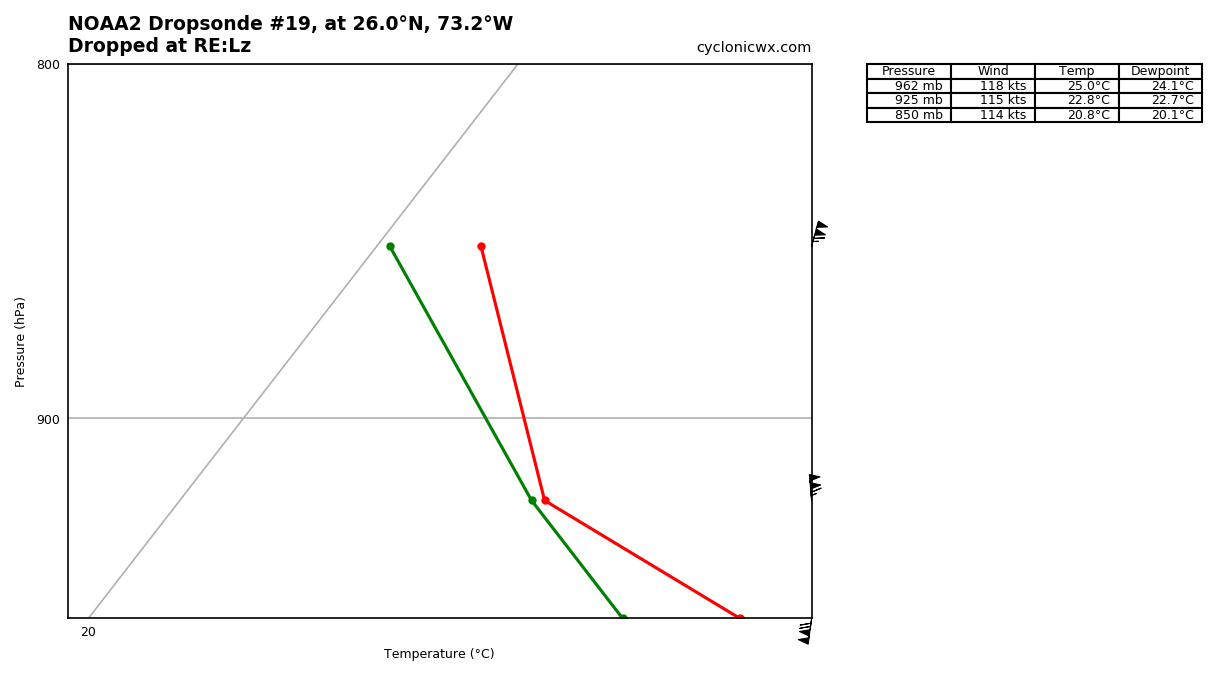
A sonde landed in southerly winds w/ 118kts, factoring in system speed which affects wind on north side, closer to 130kt max is reasonable

Image
0 likes   
This post was probably an opinion of mine, and in no way is official. Please refer to http://www.hurricanes.gov for official tropical analysis and advisories.

My website, with lots of tropical wx graphics, including satellite and recon: http://cyclonicwx.com

User avatar
Kazmit
Category 5
Category 5
Posts: 2125
Age: 22
Joined: Mon Jul 25, 2016 8:49 am
Location: Williamsburg, VA / Bermuda

Re: ATL: DORIAN - Hurricane - Discussion

#4322 Postby Kazmit » Sat Aug 31, 2019 8:49 am

Cat 5 will be a close call for sure. It will probably be peaking soon.
0 likes   
Igor 2010, Sandy 2012, Fay 2014, Gonzalo 2014, Joaquin 2015, Nicole 2016, Humberto 2019

I am only a tropical weather enthusiast. My predictions are not official and may or may not be backed by sound meteorological data. For official information, please refer to the NHC and NWS products.

Aric Dunn
Category 5
Category 5
Posts: 21238
Age: 42
Joined: Sun Sep 19, 2004 9:58 pm
Location: Ready for the Chase.
Contact:

Re: ATL: DORIAN - Hurricane - Discussion

#4323 Postby Aric Dunn » Sat Aug 31, 2019 8:50 am

Ok what did i miss lol..
4 likes   
Note: If I make a post that is brief. Please refer back to previous posts for the analysis or reasoning. I do not re-write/qoute what my initial post said each time.
If there is nothing before... then just ask :)

Space & Atmospheric Physicist, Embry-Riddle Aeronautical University,
I believe the sky is falling...

User avatar
NDG
S2K Supporter
S2K Supporter
Posts: 15448
Joined: Sun Jul 09, 2006 10:14 pm
Location: Orlando, FL

Re: ATL: DORIAN - Hurricane - Discussion

#4324 Postby NDG » Sat Aug 31, 2019 8:50 am

Still some nice ridging to the north of Dorian, 592dm heights at h50 along the SE Coast, also look at the easterly winds in the mid levels over Miami, that mid to upper level low to the SW of Dorian might still be influencing it.

Image
2 likes   

User avatar
Jr0d
S2K Supporter
S2K Supporter
Posts: 1409
Joined: Tue Aug 27, 2019 10:52 am
Location: Cayo Hueso

Re: ATL: DORIAN - Hurricane - Discussion

#4325 Postby Jr0d » Sat Aug 31, 2019 8:51 am

It is important to note key factors the models missed. IF current observations show the models over/underestimated the ridge ULL, and/or the strength and timing of the trough, as well as the speed and direction of the storm there will be major errors on those models.

This one thing the pros do best. Especially at the NHC. Model interpretation and making adjustments to the forecast track based on observed errors with model runs is crucial for accurate forecasting.

There is a reason the NHC forecasted track is much more accurate than the best computer models.
6 likes   

User avatar
Canelaw99
S2K Supporter
S2K Supporter
Posts: 2127
Age: 48
Joined: Tue Aug 31, 2004 8:27 am
Location: Homestead, FL

Re: ATL: DORIAN - Hurricane - Discussion

#4326 Postby Canelaw99 » Sat Aug 31, 2019 8:52 am

NDG wrote:Still some nice ridging to the north of Dorian, 592dm heights at h50 along the SE Coast, also look at the easterly winds in the mid levels over Miami, that mid to upper level low to the SW of Dorian might still be influencing it.

https://i.imgur.com/X2GICRy.gif

And what does this mean ? :?:
0 likes   

User avatar
La Sirena
Category 1
Category 1
Posts: 307
Joined: Sun Aug 21, 2016 4:02 pm
Location: Formerly of the Keys, back home in East TN

Re: ATL: DORIAN - Hurricane - Discussion

#4327 Postby La Sirena » Sat Aug 31, 2019 8:54 am

Aric Dunn wrote:Ok what did i miss lol..

At least 5 more people gave the all clear for Florida, some mused that Dorian will be a Cat 5 by 11 am today, surface winds reported to be around 135 kts, the interesting little westerly track it’s taking, and the fact that the NHC moved the track right....I think that covers it :lol:
22 likes   
The posts in this forum are NOT official forecasts and should not be used as such. They are just the opinion of the poster and may or may not be backed by sound meteorological data. They are NOT endorsed by any professional institution or STORM2K. For official information, please refer to products from the NHC and NWS.

User avatar
GCANE
S2K Supporter
S2K Supporter
Posts: 11503
Joined: Mon Oct 22, 2007 8:03 am

Re: ATL: DORIAN - Hurricane - Discussion

#4328 Postby GCANE » Sat Aug 31, 2019 8:55 am

The diabatic ridge may slow down Dorian's forward motion more if intensification continues.
Possible it may miss the effects of the Midwest Trough.
1 likes   

User avatar
NDG
S2K Supporter
S2K Supporter
Posts: 15448
Joined: Sun Jul 09, 2006 10:14 pm
Location: Orlando, FL

Re: ATL: DORIAN - Hurricane - Discussion

#4329 Postby NDG » Sat Aug 31, 2019 8:55 am

Canelaw99 wrote:
NDG wrote:Still some nice ridging to the north of Dorian, 592dm heights at h50 along the SE Coast, also look at the easterly winds in the mid levels over Miami, that mid to upper level low to the SW of Dorian might still be influencing it.

https://i.imgur.com/X2GICRy.gif

And what does this mean ? :?:


If ridging stays stronger than what the models show a more westward track of Dorian before the ridge starts weakening and starts slowing down before feeling the weakness developing in a couple of days or so. IMO.
2 likes   

User avatar
1900hurricane
Category 5
Category 5
Posts: 6059
Age: 34
Joined: Fri Feb 06, 2015 12:04 pm
Location: Houston, TX
Contact:

Re: ATL: DORIAN - Hurricane - Discussion

#4330 Postby 1900hurricane » Sat Aug 31, 2019 8:56 am

NDG wrote:Still some nice ridging to the north of Dorian, 592dm heights at h50 along the SE Coast, also look at the easterly winds in the mid levels over Miami, that mid to upper level low to the SW of Dorian might still be influencing it.

https://i.imgur.com/X2GICRy.gif

My eyes are on the shortwave traversing the Mississippi Valley right now. That's what is going to weaken the ridging and potentially break down steering.
2 likes   
Contract Meteorologist. TAMU & MSST. Fiercely authentic, one of a kind. We are all given free will, so choose a life meant to be lived. We are the Masters of our own Stories.
Opinions expressed are mine alone.

Follow me on Twitter at @1900hurricane : Read blogs at https://1900hurricane.wordpress.com/

User avatar
feederband
S2K Supporter
S2K Supporter
Posts: 3423
Joined: Wed Oct 01, 2003 6:21 pm
Location: Lakeland Fl

Re: ATL: DORIAN - Hurricane - Discussion

#4331 Postby feederband » Sat Aug 31, 2019 8:58 am

1 likes   

User avatar
Ntxw
Storm2k Moderator
Storm2k Moderator
Posts: 22792
Joined: Wed Oct 21, 2009 6:34 pm
Location: DFW, Texas

Re: ATL: DORIAN - Hurricane - Discussion

#4332 Postby Ntxw » Sat Aug 31, 2019 9:00 am

Will be interesting if recon finds a Cat 5 later today barring conventional methods estimates don't meet that (purpose of other basins) . The visible images are stunning but scary seeing the landmasses.

Image
4 likes   
The above post and any post by Ntxw is NOT an official forecast and should not be used as such. It is just the opinion of the poster and may or may not be backed by sound meteorological data. It is NOT endorsed by any professional institution including Storm2k. For official information, please refer to NWS products.

  Help support Storm2K!
Help Support Storm2K


User avatar
1900hurricane
Category 5
Category 5
Posts: 6059
Age: 34
Joined: Fri Feb 06, 2015 12:04 pm
Location: Houston, TX
Contact:

Re: ATL: DORIAN - Hurricane - Discussion

#4334 Postby 1900hurricane » Sat Aug 31, 2019 9:01 am

12Z best track data has the Integrated Kinetic Energy (IKE) at a comparable level to Harvey '17 at peak intensity, both about 24 TJ, just in case people are wondering about size comparisons. Also similar to Andrew '92 (~25 TJ using CSU's enhanced best track wind radii).
3 likes   
Contract Meteorologist. TAMU & MSST. Fiercely authentic, one of a kind. We are all given free will, so choose a life meant to be lived. We are the Masters of our own Stories.
Opinions expressed are mine alone.

Follow me on Twitter at @1900hurricane : Read blogs at https://1900hurricane.wordpress.com/

User avatar
Jr0d
S2K Supporter
S2K Supporter
Posts: 1409
Joined: Tue Aug 27, 2019 10:52 am
Location: Cayo Hueso

Re: ATL: DORIAN - Hurricane - Discussion

#4335 Postby Jr0d » Sat Aug 31, 2019 9:02 am

melhow wrote:
Jr0d wrote:
NDG wrote:Who remembers when John Hope used to say on TWC that the flow of the high cirrus clouds was a sign to follow of where the Hurricane was headed? So true!


Definitely something to keep in mind after a wild model shift.


I think you can see this with Hurricane Matthew? I watched a few times and the theory seemed to hold true, at least with that storm. I tried to see if I could see the effect with Irma footage, but that storm was just so dang BIG, I couldn’t tell what I was looking at. It would be interesting to see if anyone could find the effect with Irma, though, just because the three day forecast swung so much with her.

https://youtu.be/HPALhC_OtXk


I am going to have to find some larger scale satellite views of past storms to really study this.

It is quite concerning those high clouds are aimed at S/CFL for sure. None of us want to see a landfall there.

We do not want John Hope to be right in this case, but I would not bet against his wisdom.
2 likes   

jlauderdal
S2K Supporter
S2K Supporter
Posts: 7185
Joined: Wed May 19, 2004 5:46 am
Location: NE Fort Lauderdale
Contact:

Re: ATL: DORIAN - Hurricane - Discussion

#4336 Postby jlauderdal » Sat Aug 31, 2019 9:02 am

La Sirena wrote:
Aric Dunn wrote:Ok what did i miss lol..

At least 5 more people gave the all clear for Florida, some mused that Dorian will be a Cat 5 by 11 am today, surface winds reported to be around 135 kts, the interesting little westerly track it’s taking, and the fact that the NHC moved the track right....I think that covers it :lol:
john morales on nbc miami sure is optimistic this morning

https://twitter.com/JohnMoralesNBC6/sta ... 0252784640

If the current NHC forecast track for Dorian were to be 100% accurate, the Keys, Miami-Dade *and* Broward counties would be left *out* of the tropical storm force wind field! Optimism grows, and this morning's models allow for my confidence level to grow too!
1 likes   

Aric Dunn
Category 5
Category 5
Posts: 21238
Age: 42
Joined: Sun Sep 19, 2004 9:58 pm
Location: Ready for the Chase.
Contact:

Re: ATL: DORIAN - Hurricane - Discussion

#4337 Postby Aric Dunn » Sat Aug 31, 2019 9:02 am

yeah seems like ridging and steering is hold strong for now. all this westward motion should have effects on the 12z models. dorian was supposed to arch to the wnw not come straight west which will make it possibly come in farther south.
0 likes   
Note: If I make a post that is brief. Please refer back to previous posts for the analysis or reasoning. I do not re-write/qoute what my initial post said each time.
If there is nothing before... then just ask :)

Space & Atmospheric Physicist, Embry-Riddle Aeronautical University,
I believe the sky is falling...

User avatar
Hypercane_Kyle
Category 5
Category 5
Posts: 3355
Joined: Sat Mar 07, 2015 7:58 pm
Location: Cape Canaveral, FL

Re: ATL: DORIAN - Hurricane - Discussion

#4338 Postby Hypercane_Kyle » Sat Aug 31, 2019 9:03 am

VDM suggests Dorian may have become a Category 5.

Product: Air Force Vortex Message (URNT12 KNHC)
Transmitted: 31st day of the month at 13:49Z
Agency: United States Air Force
Aircraft: Lockheed WC-130J Hercules with reg. number AF96-5302
Storm Number & Year: 05 in 2019
Storm Name: Dorian (flight in the North Atlantic basin)
Mission Number: 23
Observation Number: 11

A. Time of Center Fix: 31st day of the month at 13:27:10Z
B. Center Fix Coordinates: 25.88N 73.17W
B. Center Fix Location: 268 statute miles (431 km) to the ENE (78°) from Nassau, Bahamas.
C. Minimum Height at Standard Level: 2,622m (8,602ft) at 700mb
D. Minimum Sea Level Pressure: 945mb (27.91 inHg)
E. Dropsonde Surface Wind at Center: From 85° at 8kts (From the E at 9mph)
F. Eye Character: Closed
G. Eye Shape & Diameter: Circular with a diameter of 14 nautical miles (16 statute miles)
H. Estimated (by SFMR or visually) Maximum Surface Wind Inbound: 141kts (162.3mph)

I. Location & Time of the Estimated Maximum Surface Wind Inbound: 10 nautical miles (12 statute miles) to the NE (42°) of center fix at 13:24:00Z
J. Maximum Flight Level Wind Inbound: From 125° at 131kts (From the SE at 150.8mph)
K. Location & Time of the Maximum Flight Level Wind Inbound: 10 nautical miles (12 statute miles) to the NE (42°) of center fix at 13:24:00Z
L. Estimated (by SFMR or visually) Maximum Surface Wind Outbound: 117kts (134.6mph)
M. Location & Time of the Estimated Maximum Surface Wind Outbound: 6 nautical miles to the SW (227°) of center fix at 13:29:00Z
N. Maximum Flight Level Wind Outbound: From 312° at 108kts (From the NW at 124.3mph)
O. Location & Time of the Maximum Flight Level Wind Outbound: 6 nautical miles to the SW (227°) of center fix at 13:29:00Z
P. Maximum Flight Level Temp & Pressure Altitude Outside Eye: 8°C (46°F) at a pressure alt. of 3,086m (10,125ft)
Q. Maximum Flight Level Temp & Pressure Altitude Inside Eye: 19°C (66°F) at a pressure alt. of 3,044m (9,987ft)
R. Dewpoint Temp & Sea Surface Temp: Not Available
S. Fix Determined By: Penetration, Radar, Wind, Pressure and Temperature
S. Fix Level: 700mb
T. Navigational Fix Accuracy: 0.02 nautical miles
T. Meteorological Accuracy: 1 nautical mile

Remarks Section:

Maximum Flight Level Wind: 131kts (~ 150.8mph) which was observed 10 nautical miles (12 statute miles) to the NE (42°) from the flight level center at 13:24:00Z
1 likes   
My posts are my own personal opinion, defer to the National Hurricane Center (NHC) and other NOAA products for decision making during hurricane season.

User avatar
Evenstar
S2K Supporter
S2K Supporter
Posts: 186
Joined: Mon Aug 11, 2008 1:11 pm
Location: Chesapeake, Virginia

Re: ATL: DORIAN - Hurricane - Discussion

#4339 Postby Evenstar » Sat Aug 31, 2019 9:05 am

GCANE wrote:The diabatic ridge may slow down Dorian's forward motion more if intensification continues.
Possible it may miss the effects of the Midwest Trough.


Is there a difference between a diabatic ridge compared to other types (assuming there are other types) of ridges? Something tells me "diabatic" has nothing to do with blood sugar levels, so I thought I'd ask.
4 likes   
I never received my Hogwarts letter, so I'm leaving the Shire and becoming a Sith Lord.

User avatar
cycloneye
Admin
Admin
Posts: 145710
Age: 68
Joined: Thu Oct 10, 2002 10:54 am
Location: San Juan, Puerto Rico

Re: ATL: DORIAN - Hurricane - Discussion

#4340 Postby cycloneye » Sat Aug 31, 2019 9:06 am

Aric Dunn wrote:Ok what did i miss lol..


Is there a circulation? :D
7 likes   
Visit the Caribbean-Central America Weather Thread where you can find at first post web cams,radars
and observations from Caribbean basin members Click Here


Return to “2019”

Who is online

Users browsing this forum: No registered users and 5 guests