
Makes no sense all those U.K.met models going the opposite again.
Sent from my iPad using Tapatalk
ATL: DORIAN - Models
Moderator: S2k Moderators
Re: ATL: DORIAN - Models
2 likes
-
catskillfire51
- S2K Supporter

- Posts: 480
- Age: 39
- Joined: Sun Aug 26, 2012 5:40 pm
- Location: Lake Jackson, TX
Re: ATL: DORIAN - Models
rdcrds wrote:Makes no sense all those U.K.met models going the opposite again.
Sent from my iPad using Tapatalk
Same thing people were saying when ukmet had it missing PR, but it verified. It's hard to point out exactly what one model sees that another doesn't.
1 likes
-
gatorcane

- S2K Supporter
- Posts: 23708
- Age: 48
- Joined: Sun Mar 13, 2005 3:54 pm
- Location: Boca Raton, FL
Re: ATL: DORIAN - Models
The UKMET ensembles look a lot different than the European ensembles.
3 likes
-
TheProfessor

- Professional-Met

- Posts: 3506
- Age: 29
- Joined: Tue Dec 03, 2013 10:56 am
- Location: Wichita, Kansas
Re: ATL: DORIAN - Models
0z NAM is a tick faster and further northwest of the 18z run.
1 likes
An alumnus of The Ohio State University.
Your local National Weather Service office is your best source for weather information.
Your local National Weather Service office is your best source for weather information.
-
beachman80
Re: ATL: DORIAN - Models
supercane4867 wrote:https://twitter.com/RyanMaue/status/1167613286357118978
This is great news. Looking better and better for us here in FL
1 likes

Re: ATL: DORIAN - Models
MrJames wrote:gatorcane wrote:Can somebody post the 12Z UKMET ensembles? Levi showed them and I was surprised how many were into SE Florida.
12Z UKMet Ensembles
https://i.imgur.com/Rrakajc.png
One into Vermillion Bay, and quite a few into the panhandle.
0 likes
Personal Forecast Disclaimer:
The posts in this forum are NOT official forecast and should not be used as such. They are just the opinion of the poster and may or may not be backed by sound meteorological data. They are NOT endorsed by any professional institution or storm2k.org. For official information, please refer to the NHC and NWS products.
The posts in this forum are NOT official forecast and should not be used as such. They are just the opinion of the poster and may or may not be backed by sound meteorological data. They are NOT endorsed by any professional institution or storm2k.org. For official information, please refer to the NHC and NWS products.
-
TheProfessor
- Professional-Met
- Posts: 3506
- Age: 29
- Joined: Tue Dec 03, 2013 10:56 am
- Location: Wichita, Kansas
Re: ATL: DORIAN - Models
0z NAM has much more of a trough in the 250mb flow over the U.S swooping down then it did during the 18z run.
0 likes
An alumnus of The Ohio State University.
Your local National Weather Service office is your best source for weather information.
Your local National Weather Service office is your best source for weather information.
-
southerngale

- Retired Staff

- Posts: 27418
- Joined: Thu Oct 10, 2002 1:27 am
- Location: Southeast Texas (Beaumont area)
Re: ATL: DORIAN - Models
This was posted in the Discussion thread. A great explanation of some of the models and the setup.
gatorcane wrote:New video from Levi. A must watch. He explains how much uncertainty there is here. He definitely is not taking South Florida off the table. The UKMET ensembles he posted are really interesting. Seems most are into SE Florida.
https://www.tropicaltidbits.com/
5 likes
Please support Storm2k by making a donation today. It is greatly appreciated! Click here: 
 my Cowboys my Rockets my Astros
my Cowboys my Rockets my Astros-
Aric Dunn
- Category 5

- Posts: 21238
- Age: 43
- Joined: Sun Sep 19, 2004 9:58 pm
- Location: Ready for the Chase.
- Contact:
Re: ATL: DORIAN - Models
TheProfessor wrote:0z NAM has much more of a trough in the 250mb flow over the U.S swooping down then it did during the 18z run.
yeah its odd. it also started with a much stronger ridge than the 18z.
1 likes
Note: If I make a post that is brief. Please refer back to previous posts for the analysis or reasoning. I do not re-write/qoute what my initial post said each time.
If there is nothing before... then just ask
Space & Atmospheric Physicist, Embry-Riddle Aeronautical University,
I believe the sky is falling...
If there is nothing before... then just ask
Space & Atmospheric Physicist, Embry-Riddle Aeronautical University,
I believe the sky is falling...
-
South Texas Storms

- Professional-Met
- Posts: 4259
- Joined: Thu Jun 24, 2010 12:28 am
- Location: Houston, TX
Re: ATL: DORIAN - Models
Blinhart wrote:MrJames wrote:gatorcane wrote:Can somebody post the 12Z UKMET ensembles? Levi showed them and I was surprised how many were into SE Florida.
12Z UKMet Ensembles
https://i.imgur.com/Rrakajc.png
One into Vermillion Bay, and quite a few into the panhandle.
UKMET Ensembles were horrible with Barry. Most were pointed at TX for several runs and we know how that turned out.
1 likes
-
HurricaneEnzo

- Category 2

- Posts: 744
- Joined: Wed Mar 14, 2018 12:18 pm
- Location: Newport, NC (Hurricane Alley)
Re: ATL: DORIAN - Models
No one is out of the woods yet. They don't call it the 'windshield wiper' effect for nothing. If the next few model runs keep it OTS they might be onto something but we have to wait and see.
Please stay vigilant if you are in a potential impact area!
Sent from my SM-N975U using Tapatalk
Please stay vigilant if you are in a potential impact area!
Sent from my SM-N975U using Tapatalk
Last edited by HurricaneEnzo on Fri Aug 30, 2019 9:19 pm, edited 1 time in total.
1 likes
Bertha 96' - Fran 96' - Bonnie 98' - Dennis 99' - Floyd 99' - Isabel 03' - Alex 04' - Ophelia 05' - Irene 11' - Arthur 14' - Matthew 16' - Florence 18' - Dorian 19' - Isaias 20' (countless other tropical storms and Hurricane swipes)
I am not a Professional Met just an enthusiast. Get your weather forecasts from the Pros!
I am not a Professional Met just an enthusiast. Get your weather forecasts from the Pros!
-
DESTRUCTION5

- Category 5
- Posts: 4430
- Age: 44
- Joined: Wed Sep 03, 2003 11:25 am
- Location: Stuart, FL

Re: ATL: DORIAN - Models
sma10 wrote:Levi Cowan's video on the main tropicaltidbits.com website is ABSOLUTE required viewing for anyone following this storm. It's a mix of hard science and common sense.
Very good video indeed.
0 likes
-
Bocadude85

- Category 5
- Posts: 2991
- Age: 39
- Joined: Mon Apr 18, 2005 2:20 pm
- Location: Honolulu,Hi
Re: ATL: DORIAN - Models
0z NAM stalls Dorian on the Palm Beach/Martin County coast and the eyewall is just pounding the costal areas
0 likes
-
TheProfessor
- Professional-Met
- Posts: 3506
- Age: 29
- Joined: Tue Dec 03, 2013 10:56 am
- Location: Wichita, Kansas
Re: ATL: DORIAN - Models
0z NAM have a very short wsw movement before turning wnw at hour 60. I have to imagine that the much deeper 250mb trough is keeping the 250mb high in the Gulf at bay, allowing the storm to move more northward.
0 likes
An alumnus of The Ohio State University.
Your local National Weather Service office is your best source for weather information.
Your local National Weather Service office is your best source for weather information.
-
gatorcane
- S2K Supporter
- Posts: 23708
- Age: 48
- Joined: Sun Mar 13, 2005 3:54 pm
- Location: Boca Raton, FL
Re: ATL: DORIAN - Models
00Z NAM barely moving Dorian west over Jupiter/ West Palm Beach:
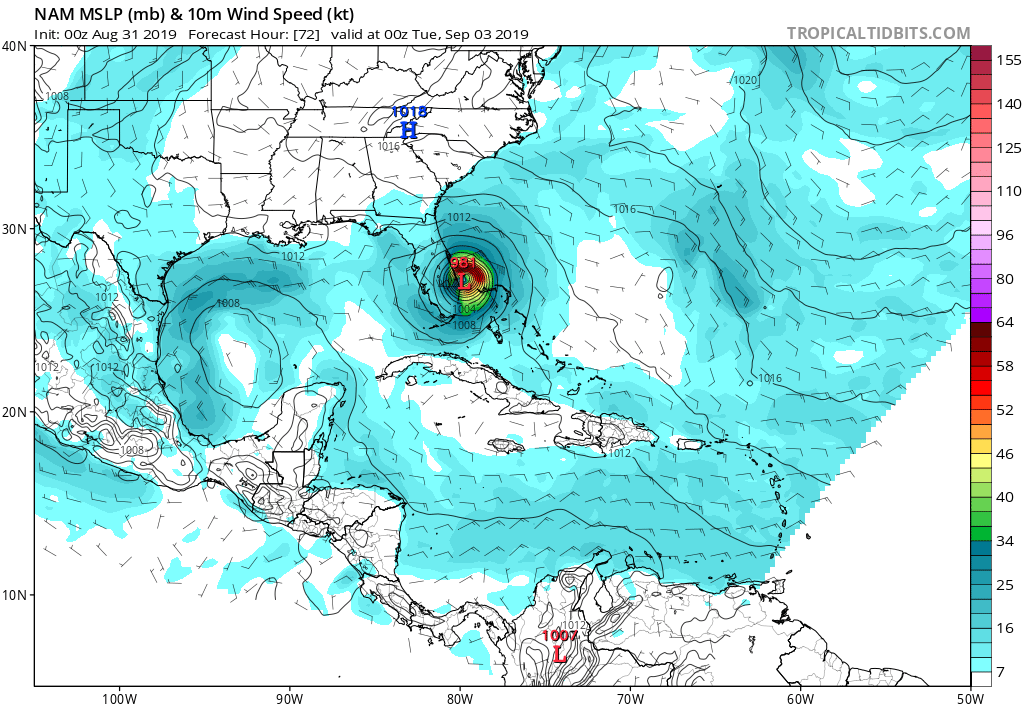
Last edited by gatorcane on Fri Aug 30, 2019 9:35 pm, edited 1 time in total.
0 likes
-
HurricaneFrances04
- Category 2
- Posts: 597
- Joined: Mon Jun 25, 2012 8:09 am
- Location: Fort Lauderdale, Florida
Re: ATL: DORIAN - Models
Bocadude85 wrote:0z NAM stalls Dorian on the Palm Beach/Martin County coast and the eyewall is just pounding the costal areas
Yeah, that's a decent NW shift from the past few runs which had it meandering in the Bahamas. Although, now it may be meandering just off the Florida coast.
0 likes
-
beachman80
Re: ATL: DORIAN - Models
Two reasons to keep an eye on the models tonight...the UKMET ensembles and the 18z Euro which stalled out the storm completely in GB.
1 likes

Re: ATL: DORIAN - Models
Subtle shifts in the atmosphere can cause a track to swing 50 miles one way or the other. Looking at the peninsula and the way its shaped and the angle of approach we just don't have the tools or the science to narrow it down 4-5 days away. Levi Cowan has an excellent video on the factors influencing steering and how subtle changes resulted in models clustering on the west coast yesterday but resulted more east coast from today's model runs.
2 likes
-
gatorcane
- S2K Supporter
- Posts: 23708
- Age: 48
- Joined: Sun Mar 13, 2005 3:54 pm
- Location: Boca Raton, FL
Re: ATL: DORIAN - Models
How 00Z NAM ends. Has Dorian creeping due west:
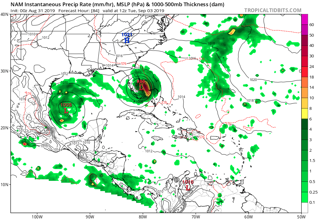
Last edited by gatorcane on Fri Aug 30, 2019 9:41 pm, edited 1 time in total.
0 likes
Who is online
Users browsing this forum: No registered users and 55 guests