
ATL: DORIAN - Post-Tropical - Discussion
Moderator: S2k Moderators
-
alienstorm

- Category 1

- Posts: 496
- Joined: Tue Jul 31, 2007 1:29 pm
- Location: Miami Fla western suburb
Re: ATL: DORIAN - Hurricane - Discussion
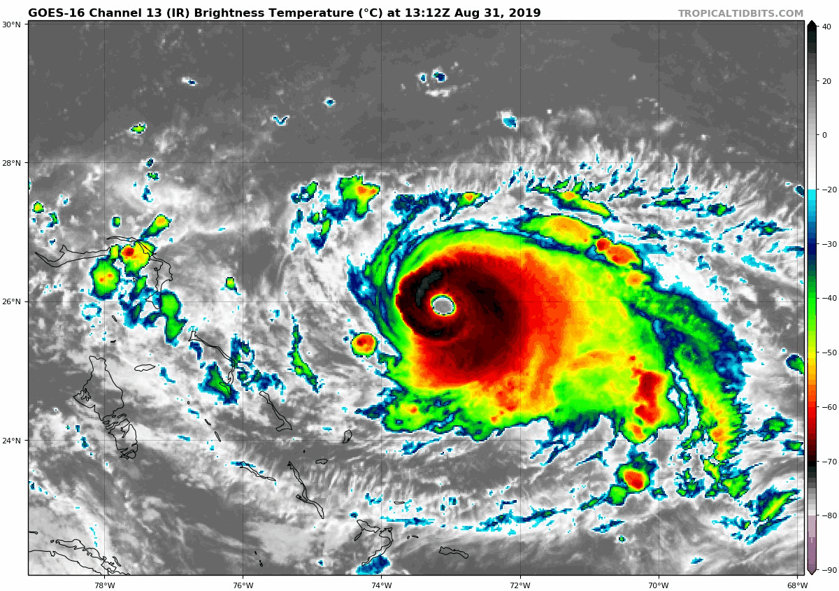
Moving along at 26N
2 likes
Personal Forecast Disclaimer:The posts in this forum are NOT official forecast and should not be used as such. They are just the opinion of the poster and may or may not be backed by sound meteorological data. They are NOT endorsed by any professional institution or storm2k.org. For official information, please refer to the NHC and NWS products.
Re: ATL: DORIAN - Hurricane - Discussion
jlauderdal wrote:People on twitter did reply and ask him about the euro, he didnt respond..craig setzer cbs miami is telling people to pause preps which seems reasonable...morales seems a little to confident considering the situationwith the modeling and the history of models having toruble with ridges, a week ago he was very confident of no florida threat, he wasnt the only one but he was really confidentLa Sirena wrote:jlauderdal wrote:john morales on nbc miami sure is optimistic this morning
https://twitter.com/JohnMoralesNBC6/sta ... 0252784640
If the current NHC forecast track for Dorian were to be 100% accurate, the Keys, Miami-Dade *and* Broward counties would be left *out* of the tropical storm force wind field! Optimism grows, and this morning's models allow for my confidence level to grow too!
I respect John and the NHC but I’m not entirely convinced to put all my eggs in that far right track basket. There’s way too many moving parts with this storm. I’ll be over here continuing to watch

One of the NHC Facebook Lives yesterday made a cool point. Lixion Avila made a point about them not wanting people to get "fatigued" with the storm. Prepare, be prepared, but don't wear yourself out/oversaturate yourself now, before potential watches are out. It was a cool point in an interesting area of meteorology--the psychology of forecasting--how you get people to act in a way that protects life and limb. Sure, it's science, but it's also human behavior. Very interesting to watch the best in the world at the NHC play that out.
5 likes

Re: ATL: DORIAN - Hurricane - Discussion
melhow wrote:Thank you for sharing this animation, it truly puts it into scale. Can someone who knows more than me please point out the John Hope cirrus cloud effect/forecast mentioned previously in other posts? I'm just curious what that looks like for this storm.
https://cdn.star.nesdis.noaa.gov//GOES1 ... 00x540.gif
It's not supposed to stall then turn north for another 48 hours or so. So far no cirrus clouds going nort(or northwest), they are shooting west.
1 likes
-
Aric Dunn
- Category 5

- Posts: 21238
- Age: 43
- Joined: Sun Sep 19, 2004 9:58 pm
- Location: Ready for the Chase.
- Contact:
Re: ATL: DORIAN - Hurricane - Discussion
looks like a ERC has started.. last two recon passes below. Explains the wobbling eye all over the place.
the pass on the right has not sign of a secondary wind max.. but the most recent pass does have two small peaks.. those should continue to grow.

the pass on the right has not sign of a secondary wind max.. but the most recent pass does have two small peaks.. those should continue to grow.
1 likes
Note: If I make a post that is brief. Please refer back to previous posts for the analysis or reasoning. I do not re-write/qoute what my initial post said each time.
If there is nothing before... then just ask
Space & Atmospheric Physicist, Embry-Riddle Aeronautical University,
I believe the sky is falling...
If there is nothing before... then just ask
Space & Atmospheric Physicist, Embry-Riddle Aeronautical University,
I believe the sky is falling...
-
La Sirena

- Category 1
- Posts: 308
- Joined: Sun Aug 21, 2016 4:02 pm
- Location: Formerly of the Keys, back home in East TN
Re: ATL: DORIAN - Hurricane - Discussion
jlauderdal wrote:People on twitter did reply and ask him about the euro, he didnt respond..craig setzer cbs miami is telling people to pause preps which seems reasonable...morales seems a little to confident considering the situationwith the modeling and the history of models having toruble with ridges, a week ago he was very confident of no florida threat, he wasnt the only one but he was really confidentLa Sirena wrote:jlauderdal wrote:john morales on nbc miami sure is optimistic this morning
https://twitter.com/JohnMoralesNBC6/sta ... 0252784640
If the current NHC forecast track for Dorian were to be 100% accurate, the Keys, Miami-Dade *and* Broward counties would be left *out* of the tropical storm force wind field! Optimism grows, and this morning's models allow for my confidence level to grow too!
I respect John and the NHC but I’m not entirely convinced to put all my eggs in that far right track basket. There’s way too many moving parts with this storm. I’ll be over here continuing to watch
I guess that’s why John gets paid the big bucks yet I’m still over here feeling less confident
It’s just curious to me how they are looking to be the big dog who called it a week ago and gain viewer confidence....but the governor is still out there doing the hurricane prep tour.
1 likes
The posts in this forum are NOT official forecasts and should not be used as such. They are just the opinion of the poster and may or may not be backed by sound meteorological data. They are NOT endorsed by any professional institution or STORM2K. For official information, please refer to products from the NHC and NWS.
Hurricane Irma,Hurricane Michael, Hurricane Helene

Re: ATL: DORIAN - Hurricane - Discussion
Stair stepping towards 26N now, but broadly still on a 275-280 motion. These wobbles are going to become increasingly important for the Bahamas over the next 24hrs.
3 likes
Personal Forecast Disclaimer:
The posts in this forum are NOT official forecast and should not be used as such. They are just the opinion of the poster and may or may not be backed by sound meteorological data. They are NOT endorsed by any professional institution or storm2k.org. For official information, please refer to the NHC and NWS products
The posts in this forum are NOT official forecast and should not be used as such. They are just the opinion of the poster and may or may not be backed by sound meteorological data. They are NOT endorsed by any professional institution or storm2k.org. For official information, please refer to the NHC and NWS products
-
OuterBanker
- S2K Supporter

- Posts: 1761
- Joined: Wed Feb 26, 2003 10:53 am
- Location: Nags Head, NC
- Contact:
Re: ATL: DORIAN - Hurricane - Discussion
Aric Dunn wrote:panamatropicwatch wrote:Looking at the locations of the past several VDM locations. Dorian still appears to be on forecast track but is still below 26N, barely.
the updated forecast track.. not yesterdays.. meaning it has been south and left of the models
Dorian has just passed 26N. With any luck it will pass to the north of all the Bahamas.
Btw Aric I think Tx is pretty much out of it now.
0 likes
-
Sailingtime
- Tropical Low

- Posts: 38
- Joined: Thu Aug 29, 2019 7:02 pm
Re: ATL: DORIAN - Hurricane - Discussion
melhow wrote:Ntxw wrote:Will be interesting if recon finds a Cat 5 later today barring conventional methods estimates don't meet that (purpose of other basins) . The visible images are stunning but scary seeing the landmasses.
https://i.imgur.com/2AG9ioI.gif
Thank you for sharing this animation, it truly puts it into scale. Can someone who knows more than me please point out the John Hope cirrus cloud effect/forecast mentioned previously in other posts? I'm just curious what that looks like for this storm.
I can't quote John Hope exactly but as memory serves his theory was that if you look at the low level clouds out well ahead of the hurricane and see which way they are moving/trending - bulging out so to speak, it's a good indication of the way the hurricane will move in general. Pretty basic but in a lot of cases it seems to work.
0 likes
-
Aric Dunn
- Category 5
- Posts: 21238
- Age: 43
- Joined: Sun Sep 19, 2004 9:58 pm
- Location: Ready for the Chase.
- Contact:
Re: ATL: DORIAN - Hurricane - Discussion
OuterBanker wrote:Aric Dunn wrote:panamatropicwatch wrote:Looking at the locations of the past several VDM locations. Dorian still appears to be on forecast track but is still below 26N, barely.
the updated forecast track.. not yesterdays.. meaning it has been south and left of the models
Dorian has just passed 26N. With any luck it will pass to the north of all the Bahamas.
Btw Aric I think Tx is pretty much out of it now.
its actually riding 26n.. and still south of all yesterdays models and guidance..
hey and there is still one UKMET member into texas.. lol
1 likes
Note: If I make a post that is brief. Please refer back to previous posts for the analysis or reasoning. I do not re-write/qoute what my initial post said each time.
If there is nothing before... then just ask
Space & Atmospheric Physicist, Embry-Riddle Aeronautical University,
I believe the sky is falling...
If there is nothing before... then just ask
Space & Atmospheric Physicist, Embry-Riddle Aeronautical University,
I believe the sky is falling...
Re: ATL: DORIAN - Hurricane - Discussion
Aric Dunn wrote:OuterBanker wrote:Aric Dunn wrote:
the updated forecast track.. not yesterdays.. meaning it has been south and left of the models
Dorian has just passed 26N. With any luck it will pass to the north of all the Bahamas.
Btw Aric I think Tx is pretty much out of it now.
its actually riding 26n.. and still south of all yesterdays models and guidance..
hey and there is still one UKMET member into texas.. lol
Been riding 26 n for about 3 hours now .
0 likes

Re: ATL: DORIAN - Hurricane - Discussion
Aric Dunn wrote:OuterBanker wrote:Aric Dunn wrote:
the updated forecast track.. not yesterdays.. meaning it has been south and left of the models
Dorian has just passed 26N. With any luck it will pass to the north of all the Bahamas.
Btw Aric I think Tx is pretty much out of it now.
its actually riding 26n.. and still south of all yesterdays models and guidance..
hey and there is still one UKMET member into texas.. lol
Yep, though its still stair stepping a rough 275-280 motion overall. Won't be enough for the Bahamas though unless there is a rather more sizeable wobble to the north in the next 12hrs.
0 likes
Personal Forecast Disclaimer:
The posts in this forum are NOT official forecast and should not be used as such. They are just the opinion of the poster and may or may not be backed by sound meteorological data. They are NOT endorsed by any professional institution or storm2k.org. For official information, please refer to the NHC and NWS products
The posts in this forum are NOT official forecast and should not be used as such. They are just the opinion of the poster and may or may not be backed by sound meteorological data. They are NOT endorsed by any professional institution or storm2k.org. For official information, please refer to the NHC and NWS products
-
northjaxpro

- S2K Supporter
- Posts: 8900
- Joined: Mon Sep 27, 2010 11:21 am
- Location: Jacksonville, FL
Re: ATL: DORIAN - Hurricane - Discussion
alienstorm wrote:Moving along at 26N
https://imagizer.imageshack.com/img923/2297/1seXnq.gif
Textbook looking storm. What a beautiful satellite image!! tt NEVER, EVER ceases to amaze me these cyclones. BEAUTIFUL but DEADLY.
The Medussas of Earth is what I personally call them. I just wanted to .try to add a.liitle light hearted humor to help take the tenseness and edge off this morning....
We don't turn.into stone observing their images but.I personally get locked and frozen in moments of awestruck when they get this powerful..
Last edited by northjaxpro on Sat Aug 31, 2019 9:40 am, edited 3 times in total.
4 likes
NEVER, EVER SAY NEVER in the tropics and weather in general, and most importantly, with life itself!!
________________________________________________________________________________________
Fay 2008 Beryl 2012 Debby 2012 Colin 2016 Hermine 2016 Julia 2016 Matthew 2016 Irma 2017 Dorian 2019
________________________________________________________________________________________
Fay 2008 Beryl 2012 Debby 2012 Colin 2016 Hermine 2016 Julia 2016 Matthew 2016 Irma 2017 Dorian 2019
Re: ATL: DORIAN - Hurricane - Discussion
Peak (10s) Flt. Lvl. Wind: 131 kts (150.8 mph)
SFMR Peak (10s) Sfc. Wind: 138 kts (158.8 mph)
SFMR Peak (10s) Sfc. Wind: 138 kts (158.8 mph)
0 likes
Personal Forecast Disclaimer:
The posts in this forum are NOT official forecast and should not be used as such. They are just the opinion of the poster and may or may not be backed by sound meteorological data. They are NOT endorsed by any professional institution or storm2k.org. For official information, please refer to the NHC and NWS products.
The posts in this forum are NOT official forecast and should not be used as such. They are just the opinion of the poster and may or may not be backed by sound meteorological data. They are NOT endorsed by any professional institution or storm2k.org. For official information, please refer to the NHC and NWS products.
-
Evil Jeremy

- S2K Supporter
- Posts: 5463
- Age: 32
- Joined: Mon Apr 10, 2006 2:10 pm
- Location: Los Angeles, CA
Re: ATL: DORIAN - Hurricane - Discussion
rwfromkansas wrote:I wake up and find a huge shift east in the track despite the storm moving well left of yesterday’s track.
I must say, extremely rash and irresponsible move by the NHC. This will basically put most people on the east coast of FL into complacency.
Forecast accuracy matters. So does not making people feel safe when your own track from yesterday busted severely.
What would you rather the NHC have done instead? Not provide the most accurate interpretation of the data they are given at any moment?
1 likes
Frances 04 / Jeanne 04 / Katrina 05 / Wilma 05 / Fay 08 / Debby 12 / Andrea 13 / Colin 16 / Hermine 16 / Matthew 16 / Irma 17
Re: ATL: DORIAN - Hurricane - Discussion
Jr0d wrote:Not to discount the model shift.
As someone post before, John Hope would say follow the cirrus clouds because the storm will follow. Those cirrus clouds are going to S\CFL.
I do miss John Hope.
They did a "flashback" thing in twc with some past storm, and John Hope forecasting it on camera. It brought back good memories. He was one smart dude!
I don't see any like him now. They are (mostly) all content to just read what they are told to read instead of doing the research for themselves. I wonder if it has something to do with how much "air time" they are given? Or their level of training? Or their willingness to learn more?
IDK
0 likes
Cleo - 1964, Betsy - 1965, David - 1979, Andrew - 1992, Charlie (Francis, Ivan, Jeanne) - 2004, Irma - 2017, Ian - 2022, Milton - 2024
-
AdamFirst

- S2K Supporter
- Posts: 2490
- Age: 36
- Joined: Thu Aug 14, 2008 10:54 am
- Location: Port Saint Lucie, FL
Re: ATL: DORIAN - Hurricane - Discussion
I don't expect a large shift away from the coast in the 11 AM advisory just yet. Perhaps after the 12z guidance if that trend continues. Dont want to lull people off preparations
0 likes
Dolphins Marlins Canes Golden Panthers HEAT
Andrew 1992 - Irene 1999 - Frances 2004 - Jeanne 2004 - Wilma 2005 - Fay 2008 - Isaac 2012 - Matthew 2016 - Irma 2017 - Dorian 2019 - Ian 2022 - Nicole 2022 - Milton 2024
Andrew 1992 - Irene 1999 - Frances 2004 - Jeanne 2004 - Wilma 2005 - Fay 2008 - Isaac 2012 - Matthew 2016 - Irma 2017 - Dorian 2019 - Ian 2022 - Nicole 2022 - Milton 2024
Re: ATL: DORIAN - Hurricane - Discussion
AdamFirst wrote:I don't expect a large shift away from the coast in the 11 AM advisory just yet. Perhaps after the 12z guidance if that trend continues. Dont want to lull people off preparations
I think the key message needs to be that Florida's east coast is still very much in the cone and so people still need to keep a very close eye on it. Need to be cautious, especially given the models have a history of recurving storms too rapidly in the past.
1 likes
Personal Forecast Disclaimer:
The posts in this forum are NOT official forecast and should not be used as such. They are just the opinion of the poster and may or may not be backed by sound meteorological data. They are NOT endorsed by any professional institution or storm2k.org. For official information, please refer to the NHC and NWS products
The posts in this forum are NOT official forecast and should not be used as such. They are just the opinion of the poster and may or may not be backed by sound meteorological data. They are NOT endorsed by any professional institution or storm2k.org. For official information, please refer to the NHC and NWS products
-
AutoPenalti
- Category 5
- Posts: 4091
- Age: 29
- Joined: Mon Aug 17, 2015 4:16 pm
- Location: Ft. Lauderdale, Florida
Re: ATL: DORIAN - Hurricane - Discussion
I remember watching a YouTube video of John Hope when he was tracking Andrew in 92. I was born in 99 but by golly what a man he was for that time. He was legendary for the weather channel.
0 likes
The posts in this forum are NOT official forecasts and should not be used as such. They are just the opinion of the poster and may or may not be backed by sound meteorological data. They are NOT endorsed by any professional institution or STORM2K. For official information, please refer to products from the NHC and NWS.
Model Runs Cheat Sheet:
GFS (5:30 AM/PM, 11:30 AM/PM)
HWRF, GFDL, UKMET, NAVGEM (6:30-8:00 AM/PM, 12:30-2:00 AM/PM)
ECMWF (1:45 AM/PM)
TCVN is a weighted averaged
Re: ATL: DORIAN - Hurricane - Discussion
The town government gave the all clear for our side over here on the west coast...
This one had me worried but the High Pressure didn't have it...
This one had me worried but the High Pressure didn't have it...
0 likes
Who is online
Users browsing this forum: No registered users and 27 guests