ATL: DORIAN - Post-Tropical - Discussion

Moderator: S2k Moderators

Message
Author
Michele B
S2K Supporter
S2K Supporter
Posts: 1115
Joined: Thu Aug 25, 2016 8:08 am
Location: SWFL

Re: ATL: DORIAN - Hurricane - Discussion

#4381 Postby Michele B » Sat Aug 31, 2019 9:44 am

gatorcane wrote:I wonder why a strong Dorian (which would be influenced more my 300MB steering) wouldn’t get pushed more west into South or Central Florida with that ULL over Cuba forcing it west?

I know there are other steering levels in play here but you wonder if that ULL may have more influence than models think right now?

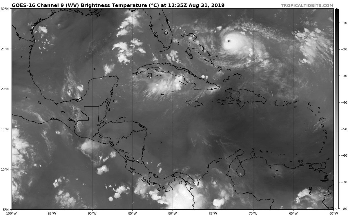
https://i.postimg.cc/kXQ7pYZy/goes16-wv-mid-watl-201908311235.jpg


I was thinking about this today, too.

Do the "steering currents" which influence a storm have something to do with how strong it is, in relation to the HEIGHT of the storm clouds?

IOW, if a very strong storm - like dorien now - has very high tops, then wouldn't the steering currents in much higher atmosphere have more influence than, say, a weaker storm whose cloud tops don't go above - maybe 25k ft?

Maybe I don't know what I'm talking about, but I am assuming that a stronger storm continues to build UPWARD as well as outward, and I wonder if that factor plays into the movement based on "jet stream" verus surface hi/low, etc.
0 likes   
Cleo - 1964, Betsy - 1965, David - 1979, Andrew - 1992, Charlie (Francis, Ivan, Jeanne) - 2004, Irma - 2017, Ian - 2022

User avatar
NDG
S2K Supporter
S2K Supporter
Posts: 15449
Joined: Sun Jul 09, 2006 10:14 pm
Location: Orlando, FL

Re: ATL: DORIAN - Hurricane - Discussion

#4382 Postby NDG » Sat Aug 31, 2019 9:45 am

AdamFirst wrote:I don't expect a large shift away from the coast in the 11 AM advisory just yet. Perhaps after the 12z guidance if that trend continues. Dont want to lull people off preparations


I agree, the NHC will probably not want to give the wrong message to FL residents at this time the all clear, anything can still happen past 72 hours. Ask the Virgin Island Residents.
4 likes   

User avatar
CyclonicFury
Category 5
Category 5
Posts: 2026
Age: 26
Joined: Sun Jul 02, 2017 12:32 pm
Location: NC
Contact:

Re: ATL: DORIAN - Hurricane - Discussion

#4383 Postby CyclonicFury » Sat Aug 31, 2019 9:46 am

I think NHC will likely go with 135 kts. During the Irma and Jose TCRs NHC said that SFMR may be unreliable in very intense storms, and Irma was actually downgraded while Jose was kept as a Category 4 despite non-suspect SFMR readings supporting Category 5. We'll see what NHC does.
0 likes   
NCSU B.S. in Meteorology Class of 2021. Tropical weather blogger at http://www.cyclonicfury.com. My forecasts and thoughts are NOT official, for official forecasts please consult the National Hurricane Center.

User avatar
1900hurricane
Category 5
Category 5
Posts: 6059
Age: 34
Joined: Fri Feb 06, 2015 12:04 pm
Location: Houston, TX
Contact:

Re: ATL: DORIAN - Hurricane - Discussion

#4384 Postby 1900hurricane » Sat Aug 31, 2019 9:46 am

Honestly, I'd probably go 135 kt for 15Z.
0 likes   
Contract Meteorologist. TAMU & MSST. Fiercely authentic, one of a kind. We are all given free will, so choose a life meant to be lived. We are the Masters of our own Stories.
Opinions expressed are mine alone.

Follow me on Twitter at @1900hurricane : Read blogs at https://1900hurricane.wordpress.com/

User avatar
1900hurricane
Category 5
Category 5
Posts: 6059
Age: 34
Joined: Fri Feb 06, 2015 12:04 pm
Location: Houston, TX
Contact:

Re: ATL: DORIAN - Hurricane - Discussion

#4385 Postby 1900hurricane » Sat Aug 31, 2019 9:48 am

4 likes   
Contract Meteorologist. TAMU & MSST. Fiercely authentic, one of a kind. We are all given free will, so choose a life meant to be lived. We are the Masters of our own Stories.
Opinions expressed are mine alone.

Follow me on Twitter at @1900hurricane : Read blogs at https://1900hurricane.wordpress.com/

User avatar
chaser1
S2K Supporter
S2K Supporter
Posts: 5495
Age: 64
Joined: Sat Oct 15, 2005 5:59 pm
Location: Longwood, Fl

Re: ATL: DORIAN - Hurricane - Discussion

#4386 Postby chaser1 » Sat Aug 31, 2019 9:48 am

Carolinagirl18 wrote:
Jr0d wrote:Not to discount the model shift.

As someone post before, John Hope would say follow the cirrus clouds because the storm will follow. Those cirrus clouds are going to S\CFL.

John Hope was a wise man.


Yep, John Hope was wise like an Owl!!! Conceptually following the cirrus clouds generally would not suggest forward motion as these clouds are at the highest levels of the atmosphere whereas the steering level more commonly applies within the mid levels within a general range from say 400 mb - 750 mb. This is generally why forecasters commonly view the 500 mb charts for steering as well as nuances in height changes caused by mid level high pressure areas and/or troughs that might weaken blocking areas of mid level high pressure. Equally important are the evolving orientations of these steering flows as well. John Hope was a treasure and observed many nuances during his many years of forecasting and tracking tropical cyclones. I believe that the reference to "following the cirrus clouds" was a suggestion of a building upper level anticyclone aloft and might suggest the steering levels that were being displayed from as high as 200mb down to perhaps into the 500mb level. These cirrus clouds therefore generally reflected a steering influence at the upper levels of the atmosphere that would probably have less influence on more shallow and weaker tropical cyclones however COULD imply a greater influence in forward motion for significantly deep and intense Hurricanes (such as Dorian). Ultimately though, deep layer steering results from the combined influence on the vertical column that broadly defines the core of the storm itself. At the moment one can see two outflow channels with cirrus streaming out to the east (on the north side of Dorian), and another outflow channel shooting west generally toward S. Florida (to the south of Dorian). This Cirrus level to the south is also being influenced by a small mid to upper level low pressure area over N. Cuba. That counter-clockwise turning feature may well be playing a role in Dorian's current and near term motion but it's size, orientation, and location will probably play less a factor in Dorian's future track relative to larger scale influences such as the projected weakening of the mid level high pressure ridge over the Southeastern CONUS north of the storm (as well as eventual building mid level heights over the N.W. Atlantic well east of Dorian). It's the broad net weight of all these influences that result in the various models forecasts. Back in the day when forecasters had less tools and data, they became savvy enough to "read" the cloud motion as indicators to what was occurring or might soon occur. To some degree, that still applies viewing satellite representation but this tool alone really gives a good snapshot of the present and near-term influences.

As for Dorian's present appearance and intensity, the current outflow channels are certainly playing a factor in Dorian maintaining (or increasing) it's near term intensity in spite of the minimal lower level shear that might be also impacting it to some degree.
9 likes   
Andy D

(For official information, please refer to the NHC and NWS products.)

User avatar
Hypercane_Kyle
Category 5
Category 5
Posts: 3359
Joined: Sat Mar 07, 2015 7:58 pm
Location: Cape Canaveral, FL

Re: ATL: DORIAN - Hurricane - Discussion

#4387 Postby Hypercane_Kyle » Sat Aug 31, 2019 9:51 am

NOAA plan found 158mph too.

May actually be a Cat 5.
4 likes   
My posts are my own personal opinion, defer to the National Hurricane Center (NHC) and other NOAA products for decision making during hurricane season.

User avatar
Blown Away
S2K Supporter
S2K Supporter
Posts: 10158
Joined: Wed May 26, 2004 6:17 am

Re: ATL: DORIAN - Hurricane - Discussion

#4388 Postby Blown Away » Sat Aug 31, 2019 9:52 am

Image
Dorian riding the 26N line... 8-)
0 likes   
Hurricane Eye Experience: David 79, Irene 99, Frances 04, Jeanne 04, Wilma 05… Hurricane Brush Experience: Andrew 92, Erin 95, Floyd 99, Matthew 16, Irma 17, Ian 22, Nicole 22…

Michele B
S2K Supporter
S2K Supporter
Posts: 1115
Joined: Thu Aug 25, 2016 8:08 am
Location: SWFL

Re: ATL: DORIAN - Hurricane - Discussion

#4389 Postby Michele B » Sat Aug 31, 2019 9:53 am

Jr0d wrote:
melhow wrote:
Jr0d wrote:
Definitely something to keep in mind after a wild model shift.


I think you can see this with Hurricane Matthew? I watched a few times and the theory seemed to hold true, at least with that storm. I tried to see if I could see the effect with Irma footage, but that storm was just so dang BIG, I couldn’t tell what I was looking at. It would be interesting to see if anyone could find the effect with Irma, though, just because the three day forecast swung so much with her.

https://youtu.be/HPALhC_OtXk


I am going to have to find some larger scale satellite views of past storms to really study this.

It is quite concerning those high clouds are aimed at S/CFL for sure. None of us want to see a landfall there.

We do not want John Hope to be right in this case, but I would not bet against his wisdom.


I want to study that, too. I would concentrate on storms JUST before a turn (not once they slowed to turn, but just before that) to test out this theory.

I would not bet against John Hope, either!
2 likes   
Cleo - 1964, Betsy - 1965, David - 1979, Andrew - 1992, Charlie (Francis, Ivan, Jeanne) - 2004, Irma - 2017, Ian - 2022

Michele B
S2K Supporter
S2K Supporter
Posts: 1115
Joined: Thu Aug 25, 2016 8:08 am
Location: SWFL

Re: ATL: DORIAN - Hurricane - Discussion

#4390 Postby Michele B » Sat Aug 31, 2019 9:54 am

jlauderdal wrote:
La Sirena wrote:
Aric Dunn wrote:Ok what did i miss lol..

At least 5 more people gave the all clear for Florida, some mused that Dorian will be a Cat 5 by 11 am today, surface winds reported to be around 135 kts, the interesting little westerly track it’s taking, and the fact that the NHC moved the track right....I think that covers it :lol:
john morales on nbc miami sure is optimistic this morning

https://twitter.com/JohnMoralesNBC6/sta ... 0252784640

If the current NHC forecast track for Dorian were to be 100% accurate, the Keys, Miami-Dade *and* Broward counties would be left *out* of the tropical storm force wind field! Optimism grows, and this morning's models allow for my confidence level to grow too!


Wasn't there a storm last year like this? Where they "called it off" too early, and then had to walk it back a little later in the day?
0 likes   
Cleo - 1964, Betsy - 1965, David - 1979, Andrew - 1992, Charlie (Francis, Ivan, Jeanne) - 2004, Irma - 2017, Ian - 2022

User avatar
Hypercane_Kyle
Category 5
Category 5
Posts: 3359
Joined: Sat Mar 07, 2015 7:58 pm
Location: Cape Canaveral, FL

Re: ATL: DORIAN - Hurricane - Discussion

#4391 Postby Hypercane_Kyle » Sat Aug 31, 2019 9:55 am

Hypercane_Kyle wrote:NOAA plan found 158mph too.

May actually be a Cat 5.


Dropsonde was lower, closer to 130 knots.

A reasonable blend based on all the data -- plus the NHC's general reluctance to upgrade to a Cat 5 based solely on SFMR data -- would be 135 knots.
0 likes   
My posts are my own personal opinion, defer to the National Hurricane Center (NHC) and other NOAA products for decision making during hurricane season.

User avatar
KWT
Category 5
Category 5
Posts: 31415
Joined: Tue Aug 17, 2004 11:02 am
Location: UK!!!

Re: ATL: DORIAN - Hurricane - Discussion

#4392 Postby KWT » Sat Aug 31, 2019 9:55 am

Just a few hints from some of the 06z runs and early 12z runs that Dorian may not totally recurve out and instead doesn't get quite far enough north to begin with, causing it to bend back NW/NNW past 96hrs.

Worth keeping an eye on to see if that emerges as a pattern on the 12z runs...
1 likes   
Personal Forecast Disclaimer:
The posts in this forum are NOT official forecast and should not be used as such. They are just the opinion of the poster and may or may not be backed by sound meteorological data. They are NOT endorsed by any professional institution or storm2k.org. For official information, please refer to the NHC and NWS products

User avatar
La Sirena
Category 1
Category 1
Posts: 307
Joined: Sun Aug 21, 2016 4:02 pm
Location: Formerly of the Keys, back home in East TN

Re: ATL: DORIAN - Hurricane - Discussion

#4393 Postby La Sirena » Sat Aug 31, 2019 9:55 am

Hypercane_Kyle wrote:NOAA plan found 158mph too.

May actually be a Cat 5.

Just as someone predicted in here this a.m. :eek:

Seriously though, it’s not surprising. Dorian is quite a storm.
0 likes   
The posts in this forum are NOT official forecasts and should not be used as such. They are just the opinion of the poster and may or may not be backed by sound meteorological data. They are NOT endorsed by any professional institution or STORM2K. For official information, please refer to products from the NHC and NWS.


Hurricane Irma,Hurricane Michael, Hurricane Helene

caneseddy
Category 5
Category 5
Posts: 1173
Joined: Fri Sep 03, 2004 9:31 pm
Location: Plantation, FL

Re: ATL: DORIAN - Hurricane - Discussion

#4394 Postby caneseddy » Sat Aug 31, 2019 9:56 am

Blown Away wrote:https://i.imgur.com/x43Vevr.gif
Dorian riding the 26N line... 8-)


It sure is..that’s the same latitude as Hollywood..
0 likes   

User avatar
NDG
S2K Supporter
S2K Supporter
Posts: 15449
Joined: Sun Jul 09, 2006 10:14 pm
Location: Orlando, FL

Re: ATL: DORIAN - Hurricane - Discussion

#4395 Postby NDG » Sat Aug 31, 2019 9:56 am

It hasn't quite reached the 26th latitude yet, per the latest pass by the NOAA Recon 25 minutes ago.

14:29:30Z 25.917N 73.333W 749.9 mb
(~ 22.15 inHg) 2,048 meters
(~ 6,719 feet) 946.8 mb
(~ 27.96 inHg)
0 likes   

NYR__1994
Tropical Low
Tropical Low
Posts: 26
Joined: Thu Sep 29, 2016 1:08 pm
Location: Savannah, GA

Re: ATL: DORIAN - Hurricane - Discussion

#4396 Postby NYR__1994 » Sat Aug 31, 2019 9:56 am

Michele B wrote:
Jr0d wrote:Not to discount the model shift.

As someone post before, John Hope would say follow the cirrus clouds because the storm will follow. Those cirrus clouds are going to S\CFL.


I do miss John Hope.

They did a "flashback" thing in twc with some past storm, and John Hope forecasting it on camera. It brought back good memories. He was one smart dude!

I don't see any like him now. They are (mostly) all content to just read what they are told to read instead of doing the research for themselves. I wonder if it has something to do with how much "air time" they are given? Or their level of training? Or their willingness to learn more?

IDK


I think the on air local Mets try to walk a very fine line. The NHC is obviously the best at what they do. However they are not perfect, so if you are a local met the best you can do is repeat the message of who is known to be the best so there is a clear and concise message to the public. So if you are a local TV met and you go against the NHC forecast and you are wrong (most likely) it could be a career ender.

That is why most of us are here for, to discuss and learn about the what if’s. John Q Public doesn’t care about what ifs, they want to know what is most likely to happen and be able to respond to that threat accordingly. This is a storm with so much uncertainty that I bet the forecasters at the NHC wish they could turn off their exact forecast track and just leave the cone.
1 likes   

supercane4867
Category 5
Category 5
Posts: 4966
Joined: Wed Nov 14, 2012 10:43 am

Re: ATL: DORIAN - Hurricane - Discussion

#4397 Postby supercane4867 » Sat Aug 31, 2019 9:56 am

130kt sounds about right to me. Honestly I think it looked better yesterday evening

Image
1 likes   

SunnyThoughts
Category 5
Category 5
Posts: 2263
Joined: Wed Jul 09, 2003 12:42 pm
Location: Pensacola, Florida

Re: ATL: DORIAN - Hurricane - Discussion

#4398 Postby SunnyThoughts » Sat Aug 31, 2019 9:56 am

803
WTNT35 KNHC 311455
TCPAT5

BULLETIN
Hurricane Dorian Advisory Number 29
NWS National Hurricane Center Miami FL AL052019
1100 AM EDT Sat Aug 31 2019

...DORIAN'S FURY AIMING AT THE NORTHWESTERN BAHAMAS...


SUMMARY OF 1100 AM EDT...1500 UTC...INFORMATION
-----------------------------------------------
LOCATION...26.0N 73.4W
ABOUT 415 MI...670 KM E OF WEST PALM BEACH FLORIDA
ABOUT 260 MI...415 KM ENE OF THE NORTHWESTERN BAHAMAS
MAXIMUM SUSTAINED WINDS...150 MPH...240 KM/H
PRESENT MOVEMENT...W OR 280 DEGREES AT 8 MPH...13 KM/H
MINIMUM CENTRAL PRESSURE...945 MB...27.91 INCHES
0 likes   

AutoPenalti
Category 5
Category 5
Posts: 4035
Age: 29
Joined: Mon Aug 17, 2015 4:16 pm
Location: Ft. Lauderdale, Florida

Re: ATL: DORIAN - Hurricane - Discussion

#4399 Postby AutoPenalti » Sat Aug 31, 2019 9:56 am

NHC still holding back the 11am, they are probably ingesting new data right now.

EDIT: 150mph as of 11am.
Due W at 8mph.
Last edited by AutoPenalti on Sat Aug 31, 2019 9:57 am, edited 3 times in total.
1 likes   
The posts in this forum are NOT official forecasts and should not be used as such. They are just the opinion of the poster and may or may not be backed by sound meteorological data. They are NOT endorsed by any professional institution or STORM2K. For official information, please refer to products from the NHC and NWS.


Model Runs Cheat Sheet:
GFS (5:30 AM/PM, 11:30 AM/PM)
HWRF, GFDL, UKMET, NAVGEM (6:30-8:00 AM/PM, 12:30-2:00 AM/PM)
ECMWF (1:45 AM/PM)

TCVN
is a weighted averaged

User avatar
Hypercane_Kyle
Category 5
Category 5
Posts: 3359
Joined: Sat Mar 07, 2015 7:58 pm
Location: Cape Canaveral, FL

Re: ATL: DORIAN - Hurricane - Discussion

#4400 Postby Hypercane_Kyle » Sat Aug 31, 2019 9:56 am

NHC goes with 130 knots (probably based off dropsonde data).

11:00 AM EDT Sat Aug 31
Location: 26.0°N 73.4°W
Moving: W at 8 mph
Min pressure: 945 mb
Max sustained: 150 mph
0 likes   
My posts are my own personal opinion, defer to the National Hurricane Center (NHC) and other NOAA products for decision making during hurricane season.


Return to “2019”

Who is online

Users browsing this forum: No registered users and 4 guests