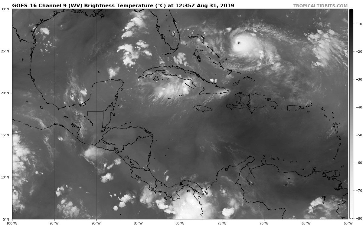
ATL: DORIAN - Post-Tropical - Discussion

Moderator: S2k Moderators

Message
Author
caneseddy
Category 5
Category 5
Posts: 1173
Joined: Fri Sep 03, 2004 9:31 pm
Location: Plantation, FL

Re: ATL: DORIAN - Hurricane - Discussion

#4441 Postby caneseddy » Sat Aug 31, 2019 10:17 am

wxman57 wrote:
otowntiger wrote:
caneseddy wrote:All of south Florida out of the cone as of 11

Yep. And another east shift like that in next advisory will have all of Florida out of the cone. Could be Very good news. I know, I know don’t let your guard down but this is definitely a solid trend right now.


The cone should be completely ignored. It means nothing as far as potential impacts or the CURRENT level of forecast uncertainty.


Completely agree yet the local news stations and Mets are saying we can breathe a sigh of relief here and people will take that as gospel..it can easily shift back west..no one knows yet
Last edited by caneseddy on Sat Aug 31, 2019 10:18 am, edited 1 time in total.
2 likes   

User avatar
TheDreamTraveler
Category 2
Category 2
Posts: 641
Joined: Sun Aug 22, 2010 3:10 am
Location: PA

Re: ATL: DORIAN - Hurricane - Discussion

#4442 Postby TheDreamTraveler » Sat Aug 31, 2019 10:18 am

It's interesting that they say Dorian could still strengthen further.

Dorian's satellite presentation is outstanding with a distinct eye
of about 15 n mi in diameter. Both NOAA and Air Force Hurricane
Hunter planes have been penetrating the eye this morning and based
on a blend of the flight-level and SFMR winds, the initial intensity
has been adjusted upward to 130 kt in this advisory. Dorian is
forecast to move over a deep layer of very warm waters, which is
like high octane-fuel for hurricanes. The combination of the warm
ocean and the prevailing low shear along Dorian's path should favor
some additional strengthening, but most likely the hurricane will
experience some fluctuations in intensity due to eyewall replacement
cycles that are difficult to predict. Beyond 3 days, as the
hurricane begins to gain in latitude a gradual weakening is
anticipated.
0 likes   

User avatar
sponger
S2K Supporter
S2K Supporter
Posts: 1620
Joined: Thu Jul 22, 2004 11:26 am
Location: St Augustine

Re: ATL: DORIAN - Hurricane - Discussion

#4443 Postby sponger » Sat Aug 31, 2019 10:19 am

So will the afternoon Euro have the pressure soundings from NOAA fed into it? Really looking forward to the next run.
2 likes   
The following post is NOT an official forecast and should not be used as such. It is just the opinion of the poster and may or may not be backed by sound meteorological data. It is NOT endorsed by any professional institution including storm2k.org For Official Information please refer to the NHC and NWS products.

jhpigott
Category 2
Category 2
Posts: 570
Joined: Wed Jan 02, 2008 8:09 pm
Location: North Palm Beach, Florida

Re: ATL: DORIAN - Hurricane - Discussion

#4444 Postby jhpigott » Sat Aug 31, 2019 10:19 am

wxman57 wrote:
otowntiger wrote:
caneseddy wrote:All of south Florida out of the cone as of 11

Yep. And another east shift like that in next advisory will have all of Florida out of the cone. Could be Very good news. I know, I know don’t let your guard down but this is definitely a solid trend right now.


The cone should be completely ignored. It means nothing as far as potential impacts or the CURRENT level of forecast uncertainty.


What's your confidence in the current forecasts? Curious what your thinking is to possible impacts to SEUS coastline
1 likes   

Michele B
S2K Supporter
S2K Supporter
Posts: 1115
Joined: Thu Aug 25, 2016 8:08 am
Location: SWFL

Re: ATL: DORIAN - Hurricane - Discussion

#4445 Postby Michele B » Sat Aug 31, 2019 10:19 am

alienstorm wrote:Here is an interesting snippet from Mark Suddath:

one thing to note about the very obvious changes in the model guidance overnight:

While it is seemingly good news to see a shift away from Florida and a possible window of opportunity for Dorian to miss making landfall anywhere along the southeast US coast, I would like to point out that from what I am reading the additional upper air samples from the NOAA high altitude yet were not in the overnight runs of the models.

Apparently, they are having trouble with the plane itself and were not able to fly this morning either.

If I understand things correctly, the 12Z models yesterday had the data but not last night - and last night was when the east shift really took root.

The reason the high-altitude data is important is because weather balloons are launched from the land based weather service offices and not from out over the ocean for obvious reasons.

The high altitude jet drops instruments around the environment of the hurricane to sample the atmosphere where there is normally no data. This has not happened in 24 hours I believe.


I remember where the plane turned back last night or something.

Knowing data that SHOULD have come from that plane did not get processed into the latest models does not give me confidence in this latest cone. I THOUGHT they shifted it too far east too soon.
3 likes   
Cleo - 1964, Betsy - 1965, David - 1979, Andrew - 1992, Charlie (Francis, Ivan, Jeanne) - 2004, Irma - 2017, Ian - 2022

User avatar
chaser1
S2K Supporter
S2K Supporter
Posts: 5495
Age: 64
Joined: Sat Oct 15, 2005 5:59 pm
Location: Longwood, Fl

Re: ATL: DORIAN - Hurricane - Discussion

#4446 Postby chaser1 » Sat Aug 31, 2019 10:20 am

Michele B wrote:
gatorcane wrote:I wonder why a strong Dorian (which would be influenced more my 300MB steering) wouldn’t get pushed more west into South or Central Florida with that ULL over Cuba forcing it west?

I know there are other steering levels in play here but you wonder if that ULL may have more influence than models think right now?

https://i.postimg.cc/kXQ7pYZy/goes16-wv-mid-watl-201908311235.jpg


I was thinking about this today, too.

Do the "steering currents" which influence a storm have something to do with how strong it is, in relation to the HEIGHT of the storm clouds?

IOW, if a very strong storm - like dorien now - has very high tops, then wouldn't the steering currents in much higher atmosphere have more influence than, say, a weaker storm whose cloud tops don't go above - maybe 25k ft?

Maybe I don't know what I'm talking about, but I am assuming that a stronger storm continues to build UPWARD as well as outward, and I wonder if that factor plays into the movement based on "jet stream" verus surface hi/low, etc.


Your thoughts have good merit and the storm itself can/does play a role with regard to how it's future motion may be affected. Deeper core hurricanes will have upper level influences play some role in their current/future motion as compared to much weaker and more shallow tropical cyclones. Likewise, small hurricanes are more apt to make small scale squarely turns and course adjustments mush like a pebble within a strong stream of water might. Meanwhile, very large hurricanes lend to much smoother tracks and in cases can actually influence upper level and steering influences immediately around them. I think it is this reason that some models (and still a few model ensemble members) were depicting Dorian making a short term southwest jog just east of Florida as a result of short term influence that a building ridge just north of Dorian and the small cut off low in the Florida Straits might cause (prior to a sudden turn toward the north or northwest). Large hurricanes are less apt to feel the effects of smaller short term influencing factors and often "push", weaken, or absorb smaller scale features.
2 likes   
Andy D

(For official information, please refer to the NHC and NWS products.)

User avatar
NDG
S2K Supporter
S2K Supporter
Posts: 15451
Joined: Sun Jul 09, 2006 10:14 pm
Location: Orlando, FL

Re: ATL: DORIAN - Hurricane - Discussion

#4447 Postby NDG » Sat Aug 31, 2019 10:22 am

wxman57 wrote:
otowntiger wrote:
caneseddy wrote:All of south Florida out of the cone as of 11

Yep. And another east shift like that in next advisory will have all of Florida out of the cone. Could be Very good news. I know, I know don’t let your guard down but this is definitely a solid trend right now.


The cone should be completely ignored. It means nothing as far as potential impacts or the CURRENT level of forecast uncertainty.


Yep, good example is the latest 06z Euro which shows some of the outer squalls to reach SE FL with the potential of TS force wind gusts with them and very rough waters by the beach.
0 likes   

Bluehawk
Tropical Low
Tropical Low
Posts: 33
Joined: Wed Sep 27, 2017 10:29 pm
Location: Boca Raton, Palm Beach County, FL

Re: ATL: DORIAN - Hurricane - Discussion

#4448 Postby Bluehawk » Sat Aug 31, 2019 10:23 am

chaser1 wrote:
wjs3 wrote:
jlauderdal wrote:People on twitter did reply and ask him about the euro, he didnt respond..craig setzer cbs miami is telling people to pause preps which seems reasonable...morales seems a little to confident considering the situationwith the modeling and the history of models having toruble with ridges, a week ago he was very confident of no florida threat, he wasnt the only one but he was really confident


One of the NHC Facebook Lives yesterday made a cool point. Lixion Avila made a point about them not wanting people to get "fatigued" with the storm. Prepare, be prepared, but don't wear yourself out/oversaturate yourself now, before potential watches are out. It was a cool point in an interesting area of meteorology--the psychology of forecasting--how you get people to act in a way that protects life and limb. Sure, it's science, but it's also human behavior. Very interesting to watch the best in the world at the NHC play that out.


That's a great post and reflects a really well learned perspective by Lixion who I used to enjoy chatting with years ago. Bottom line is when you've watched, tracked and forecasted these storms long enough, you come to the realization that many factors evolve and change 3, 4, and 5 days out. Like watching a boxing match and seeing how each boxer is "up", then fading, then "down", then "back up" again LOL, the result is an ongoing rise and fall of emotion, anxiety and anticipation. That is why there's different levels of preparation for a hurricane and why there's a time for buying supplies, a time for planning boarding up and cleaning the yard of loose items, and a time for logistics of decision and actions that relate to work, children, school/day care, and "bugging out"/evacuation. By and large, a lot of what people need to do is have an overall plan and then to simply WAIT AND WATCH.

On a related note, I'm here in Central Florida and couldn't help from laughing while watching the MANY home-owners having their lawns mowed "in preparation for the storm". I''m not making this up because I asked a couple neighbors as well as my own lawn maintenance guy :ggreen: For the life of me, I can't see the benefit of having a groomed lawn in the event that trees, my neighbors debris, and roofing material end up littered all over it following a hurricane impact. Just seems like some way of coping with nervous energy I guess LOL.


West Boca Raton resident here: We are instinctively learning this lesson today :-) We do not watch any media regarding the hurricane. The NHC and this forum help us prepare well enough! That being said, after burning ourselves out yesterday afternoon preparing (read: cleaning it and playing tetris with all the stuff in there lol) the garage to take in the patio and yard furniture, tools, etc, this morning it was an amazing sense of relief to know we are able to "wait and see" without stress, instead of waking up very early to board up the gliding doors and bring the very heavy yard furniture in. We have everything ready, and the rest of the house is protected as we have impact windows, but we can take a little break, and are very grateful for it. I maintain faith this will stay OTS, but I am well aware serious players in the modelling world (all pun intended) of hurricane tracking are still saying "hold my beer".
Edited to add: one of my friends was mowing the lawn yesterday as well LOL. I think there's a little bit of sense in that - it may take weeks until we'd be able to do it again, should the worst come to happen, and, with much rain and humidity, it'd be very difficult to cut afterwards. But... what to do with the clippings?! There's no waste disposal until it were to strike - if it did.
And another funny prep I saw yesterday: one of my neighbors was thoroughly washing her car :cheesy:
Last edited by Bluehawk on Sat Aug 31, 2019 10:32 am, edited 1 time in total.
5 likes   

User avatar
sponger
S2K Supporter
S2K Supporter
Posts: 1620
Joined: Thu Jul 22, 2004 11:26 am
Location: St Augustine

Re: ATL: DORIAN - Hurricane - Discussion

#4449 Postby sponger » Sat Aug 31, 2019 10:23 am

ICON showing landfall Broward County.
0 likes   
The following post is NOT an official forecast and should not be used as such. It is just the opinion of the poster and may or may not be backed by sound meteorological data. It is NOT endorsed by any professional institution including storm2k.org For Official Information please refer to the NHC and NWS products.

wjs3
S2K Supporter
S2K Supporter
Posts: 633
Joined: Sat Aug 14, 2004 7:57 am

Re: RE: Re: ATL: DORIAN - Hurricane - Discussion

#4450 Postby wjs3 » Sat Aug 31, 2019 10:24 am

jlauderdal wrote:
wxman57 wrote:
otowntiger wrote:Yep. And another east shift like that in next advisory will have all of Florida out of the cone. Could be Very good news. I know, I know don’t let your guard down but this is definitely a solid trend right now.


The cone should be completely ignored. It means nothing as far as potential impacts or the CURRENT level of forecast uncertainty.
Well said, the tv mets in miami follow it to the last inch on the edges..wsvn fox miami repeatedly shows the spaghetti plot with almost no explanation


I emailed WPLG earlier this morning because they are saying things like "the NHC removed Broward county from the cone of concern" or, earlier today, were naming specific cities that were n and out of the cone.

(1) The NHC draws the forecast. The cone draws itself. The NHC does not include or remove an area from the cone. They don't seem to understand that because they keep saying it.
(2) Saying places are "in" or "out" ignores that the cone represents only some of the average error. And it's just too darn precise. What, someone in Lauderdale is "out" but Pompano is "in"??
1 likes   

User avatar
Yellow Evan
Professional-Met
Professional-Met
Posts: 16169
Age: 27
Joined: Fri Jul 15, 2011 12:48 pm
Location: Henderson, Nevada/Honolulu, HI
Contact:

Re: ATL: DORIAN - Hurricane - Discussion

#4451 Postby Yellow Evan » Sat Aug 31, 2019 10:26 am

There were 142 FL winds and 141 SFMR. 90% of 142 is 128. Not sure how a blend of that yields 130 knots.
0 likes   

User avatar
Blown Away
S2K Supporter
S2K Supporter
Posts: 10158
Joined: Wed May 26, 2004 6:17 am

Re: ATL: DORIAN - Hurricane - Discussion

#4452 Postby Blown Away » Sat Aug 31, 2019 10:26 am

Image
Look at that sudden acceleration burst on latest loop... These storms are so unpredictably cool...
4 likes   
Hurricane Eye Experience: David 79, Irene 99, Frances 04, Jeanne 04, Wilma 05… Hurricane Brush Experience: Andrew 92, Erin 95, Floyd 99, Matthew 16, Irma 17, Ian 22, Nicole 22…

Michele B
S2K Supporter
S2K Supporter
Posts: 1115
Joined: Thu Aug 25, 2016 8:08 am
Location: SWFL

Re: ATL: DORIAN - Hurricane - Discussion

#4453 Postby Michele B » Sat Aug 31, 2019 10:29 am

sponger wrote:ICON showing landfall Broward County.


Where did this model come from and how reliable has it been? I never heard of it until this year.
0 likes   
Cleo - 1964, Betsy - 1965, David - 1979, Andrew - 1992, Charlie (Francis, Ivan, Jeanne) - 2004, Irma - 2017, Ian - 2022

User avatar
chaser1
S2K Supporter
S2K Supporter
Posts: 5495
Age: 64
Joined: Sat Oct 15, 2005 5:59 pm
Location: Longwood, Fl

Re: ATL: DORIAN - Hurricane - Discussion

#4454 Postby chaser1 » Sat Aug 31, 2019 10:31 am

sponger wrote:
chaser1 wrote:
wjs3 wrote:
One of the NHC Facebook Lives yesterday made a cool point. Lixion Avila made a point about them not wanting people to get "fatigued" with the storm. Prepare, be prepared, but don't wear yourself out/oversaturate yourself now, before potential watches are out. It was a cool point in an interesting area of meteorology--the psychology of forecasting--how you get people to act in a way that protects life and limb. Sure, it's science, but it's also human behavior. Very interesting to watch the best in the world at the NHC play that out.


That's a great post and reflects a really well learned perspective by Lixion who I used to enjoy chatting with years ago. Bottom line is when you've watched, tracked and forecasted these storms long enough, you come to the realization that many factors evolve and change 3, 4, and 5 days out. Like watching a boxing match and seeing how each boxer is "up", then fading, then "down", then "back up" again LOL, the result is an ongoing rise and fall of emotion, anxiety and anticipation. That is why there's different levels of preparation for a hurricane and why there's a time for buying supplies, a time for planning boarding up and cleaning the yard of loose items, and a time for logistics of decision and actions that relate to work, children, school/day care, and "bugging out"/evacuation. By and large, a lot of what people need to do is have an overall plan and then to simply WAIT AND WATCH.

On a related note, I'm here in Central Florida and couldn't help from laughing while watching the MANY home-owners having their lawns mowed "in preparation for the storm". I''m not making this up because I asked a couple neighbors as well as my own lawn maintenance guy :ggreen: For the life of me, I can't see the benefit of having a groomed lawn in the event that trees, my neighbors debris, and roofing material end up littered all over it following a hurricane impact. Just seems like some way of coping with nervous energy I guess LOL.


I always do it just because I know that it will be awhile before I can mow it, due to all the rain. If you miss your opportunity, it is a foot high by the time you can mow without sinking into it. Also a great stress reliever like any exercise.


Apparently so; well, at least one taking the effort to ease the anxiety of waiting and watching seems more productive then just watching and becoming more alarmed or anxious while sitting and staring at the satellite. I can see your point of having to mow a week higher/deeper lawn if it were that high a week or two from now. I guess I found it comical given the many other more relavent things I either had to do or help others with. Cutting the grass just wasn't in my "top 20" list.
2 likes   
Andy D

(For official information, please refer to the NHC and NWS products.)

User avatar
La Sirena
Category 1
Category 1
Posts: 307
Joined: Sun Aug 21, 2016 4:02 pm
Location: Formerly of the Keys, back home in East TN

Re: ATL: DORIAN - Hurricane - Discussion

#4455 Postby La Sirena » Sat Aug 31, 2019 10:31 am

Michele B wrote:
sponger wrote:ICON showing landfall Broward County.


Where did this model come from and how reliable has it been? I never heard of it until this year.

It is a fairly new German model.
0 likes   
The posts in this forum are NOT official forecasts and should not be used as such. They are just the opinion of the poster and may or may not be backed by sound meteorological data. They are NOT endorsed by any professional institution or STORM2K. For official information, please refer to products from the NHC and NWS.


Hurricane Irma,Hurricane Michael, Hurricane Helene

User avatar
Blown Away
S2K Supporter
S2K Supporter
Posts: 10158
Joined: Wed May 26, 2004 6:17 am

Re: ATL: DORIAN - Hurricane - Discussion

#4456 Postby Blown Away » Sat Aug 31, 2019 10:32 am

Michele B wrote:
sponger wrote:ICON showing landfall Broward County.


Where did this model come from and how reliable has it been? I never heard of it until this year.


Looking at the current NHC cone, I'd say not much consideration...
0 likes   
Hurricane Eye Experience: David 79, Irene 99, Frances 04, Jeanne 04, Wilma 05… Hurricane Brush Experience: Andrew 92, Erin 95, Floyd 99, Matthew 16, Irma 17, Ian 22, Nicole 22…

caneseddy
Category 5
Category 5
Posts: 1173
Joined: Fri Sep 03, 2004 9:31 pm
Location: Plantation, FL

Re: ATL: DORIAN - Hurricane - Discussion

#4457 Postby caneseddy » Sat Aug 31, 2019 10:33 am

Broward County mayor saying that while it appears at this moment it’s heading north, don’t let your guard down..brought up Irma how it was supposed to head up the east coast or up the spine and instead went west of us. Saying to still prepare because things can change
3 likes   

AutoPenalti
Category 5
Category 5
Posts: 4035
Age: 29
Joined: Mon Aug 17, 2015 4:16 pm
Location: Ft. Lauderdale, Florida

Re: ATL: DORIAN - Hurricane - Discussion

#4458 Postby AutoPenalti » Sat Aug 31, 2019 10:33 am

Blown Away wrote:
Michele B wrote:
sponger wrote:ICON showing landfall Broward County.


Where did this model come from and how reliable has it been? I never heard of it until this year.


Looking at the current NHC cone, I'd say not much consideration...

This run just came out...
0 likes   
The posts in this forum are NOT official forecasts and should not be used as such. They are just the opinion of the poster and may or may not be backed by sound meteorological data. They are NOT endorsed by any professional institution or STORM2K. For official information, please refer to products from the NHC and NWS.


Model Runs Cheat Sheet:
GFS (5:30 AM/PM, 11:30 AM/PM)
HWRF, GFDL, UKMET, NAVGEM (6:30-8:00 AM/PM, 12:30-2:00 AM/PM)
ECMWF (1:45 AM/PM)

TCVN
is a weighted averaged

jlauderdal
S2K Supporter
S2K Supporter
Posts: 7189
Joined: Wed May 19, 2004 5:46 am
Location: NE Fort Lauderdale
Contact:

Re: RE: Re: RE: Re: ATL: DORIAN - Hurricane - Discussion

#4459 Postby jlauderdal » Sat Aug 31, 2019 10:34 am

wjs3 wrote:
jlauderdal wrote:
wxman57 wrote:
The cone should be completely ignored. It means nothing as far as potential impacts or the CURRENT level of forecast uncertainty.
Well said, the tv mets in miami follow it to the last inch on the edges..wsvn fox miami repeatedly shows the spaghetti plot with almost no explanation


I emailed WPLG earlier this morning because they are saying things like "the NHC removed Broward county from the cone of concern" or, earlier today, were naming specific cities that were n and out of the cone.

(1) The NHC draws the forecast. The cone draws itself. The NHC does not include or remove an area from the cone. They don't seem to understand that because they keep saying it.
(2) Saying places are "in" or "out" ignores that the cone represents only some of the average error. And it's just too darn precise. What, someone in Lauderdale is "out" but Pompano is "in"??
https://twitter.com/SheliNBC6/status/1167814125428387840
1 likes   

User avatar
GeneratorPower
S2K Supporter
S2K Supporter
Posts: 1648
Age: 45
Joined: Sun Dec 18, 2005 11:48 pm
Location: Huntsville, AL

Re: ATL: DORIAN - Hurricane - Discussion

#4460 Postby GeneratorPower » Sat Aug 31, 2019 10:34 am

caneseddy wrote:Broward County mayor saying that while it appears at this moment it’s heading north, don’t let your guard down..brought up Irma how it was supposed to head up the east coast or up the spine and instead went west of us. Saying to still prepare because things can change

The wisest course of action!
2 likes   


Return to “2019”

Who is online

Users browsing this forum: No registered users and 6 guests