ATL: DORIAN - Post-Tropical - Discussion
Moderator: S2k Moderators
-
EquusStorm
- Category 5

- Posts: 1649
- Age: 35
- Joined: Thu Nov 07, 2013 1:04 pm
- Location: Jasper, AL
- Contact:
Re: ATL: DORIAN - Hurricane - Discussion
I would like to see pressures <935 or so before being confident in cat 5 winds at the surface but wind/pressure relationships aren't always spot on. We'll see.
0 likes
Colors of lost purpose on the canvas of irrelevance
Not a meteorologist, in fact more of an idiot than anything. You should probably check with the NHC or a local NWS office for official information.
Not a meteorologist, in fact more of an idiot than anything. You should probably check with the NHC or a local NWS office for official information.
-
supercane4867
- Category 5
- Posts: 4966
- Joined: Wed Nov 14, 2012 10:43 am

-
JtSmarts

- S2K Supporter

- Posts: 1442
- Age: 40
- Joined: Thu Jul 10, 2003 1:29 pm
- Location: Columbia, South Carolina
Re: ATL: DORIAN - Hurricane - Discussion
Latest Video From Levi Cowan
https://www.youtube.com/watch?v=IhOmkDxmcOY
https://www.youtube.com/watch?v=IhOmkDxmcOY
3 likes

Re: ATL: DORIAN - Hurricane - Discussion
Just heard some of the evaluation orders were recended from one county . OMG there crazy for that 
1 likes
-
Kingarabian

- S2K Supporter
- Posts: 16361
- Joined: Sat Aug 08, 2009 3:06 am
- Location: Honolulu, Hawaii
Re: ATL: DORIAN - Hurricane - Discussion
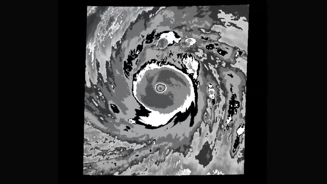
supercane4867 wrote:Still no signs of EWR on the new microwave pass. I'm quite surprised that it can hold such intense inner core for this long
https://i.imgur.com/yvRKDuy.jpg
I'm surprised it has such high winds despite the core looking like that. Makes one wonder how really under estimated EPAC hurricanes and WPAC typhoons are.
Note: please ignore my psot and keep the discussion about Dorian and let's not have a war about Typhoons and recon etc lol.
4 likes
RIP Kobe Bryant
Re: ATL: DORIAN - Hurricane - Discussion
pcolaman wrote:Just heard some of the evaluation orders were recended from one county . OMG there crazy for that
Martin County. They were going to issue the order tomorrow but they rescinded them this evening because of the new forecast track
0 likes

Re: ATL: DORIAN - Hurricane - Discussion
155 knots WPAC
135 knots (ish) Atlantic

135 knots (ish) Atlantic
2 likes
Very useful information on the Dvorak Technique --
https://severe.worldweather.wmo.int/TCF ... kBeven.pdf
https://severe.worldweather.wmo.int/TCF ... kBeven.pdf
-
Hypercane_Kyle

- Category 5
- Posts: 3465
- Joined: Sat Mar 07, 2015 7:58 pm
- Location: Cape Canaveral, FL
Re: ATL: DORIAN - Hurricane - Discussion
SFMR
148 knots
(~ 170.3 mph)
I don't see how this doesn't justify at least 135 knots.
148 knots
(~ 170.3 mph)
I don't see how this doesn't justify at least 135 knots.
0 likes
My posts are my own personal opinion, defer to the National Hurricane Center (NHC) and other NOAA products for decision making during hurricane season.

Re: ATL: DORIAN - Hurricane - Discussion
Hypercane_Kyle wrote:SFMR
148 knots
(~ 170.3 mph)
I don't see how this doesn't justify at least 135 knots.
That whole eyewall set was flagged.
0 likes
The above post is not official and should not be used as such. It is the opinion of the poster and may or may not be backed by sound meteorological data. It is not endorsed by any professional institution or storm2k.org. For official information, please refer to the NHC and NWS products.
Re: ATL: DORIAN - Hurricane - Discussion
Hammy wrote:Hypercane_Kyle wrote:SFMR
148 knots
(~ 170.3 mph)
I don't see how this doesn't justify at least 135 knots.
That whole eyewall set was flagged.
Only 1 was

1 likes
Very useful information on the Dvorak Technique --
https://severe.worldweather.wmo.int/TCF ... kBeven.pdf
https://severe.worldweather.wmo.int/TCF ... kBeven.pdf
-
supercane4867
- Category 5
- Posts: 4966
- Joined: Wed Nov 14, 2012 10:43 am
Re: ATL: DORIAN - Hurricane - Discussion
Those SFMR winds are off the charts...It's really hard to convince me that they don't matter at all. I hope an in-depth post season analysis can explain this. 
0 likes


Re: ATL: DORIAN - Hurricane - Discussion
JtSmarts wrote:Latest Video From Levi Cowan
https://www.youtube.com/watch?v=IhOmkDxmcOY
He has a great explanation of the G4 mission and the ridge that was slightly stronger that was ingested into the GFS 18z
data.
2 likes
-
Hypercane_Kyle
- Category 5
- Posts: 3465
- Joined: Sat Mar 07, 2015 7:58 pm
- Location: Cape Canaveral, FL
Re: ATL: DORIAN - Hurricane - Discussion
Hammy wrote:Hypercane_Kyle wrote:SFMR
148 knots
(~ 170.3 mph)
I don't see how this doesn't justify at least 135 knots.
That whole eyewall set was flagged.
Doesn't show up as flagged on the Tropicalatlantic site.
0 likes
My posts are my own personal opinion, defer to the National Hurricane Center (NHC) and other NOAA products for decision making during hurricane season.
-
Yellow Evan

- Professional-Met

- Posts: 16240
- Age: 27
- Joined: Fri Jul 15, 2011 12:48 pm
- Location: Henderson, Nevada/Honolulu, HI
- Contact:
Re: ATL: DORIAN - Hurricane - Discussion
Even a blend of 90% and raw SFMR would support 140 now...
1 likes
Re: ATL: DORIAN - Hurricane - Discussion
Yellow Evan wrote:Even a blend of 90% and raw SFMR would support 140 now...
Special NHC update like yesterday?
1 likes
Very useful information on the Dvorak Technique --
https://severe.worldweather.wmo.int/TCF ... kBeven.pdf
https://severe.worldweather.wmo.int/TCF ... kBeven.pdf

Re: ATL: DORIAN - Hurricane - Discussion
AF recon's vortex message from the first pass:
459
URNT12 KNHC 312357
VORTEX DATA MESSAGE AL052019
A. 31/23:22:10Z
B. 26.19 deg N 074.61 deg W
C. 700 mb 2577 m
D. 941 mb
E. 150 deg 8 kt
F. CLOSED
G. C14
H. 143 kt
I. 328 deg 8 nm 23:19:00Z
J. 061 deg 144 kt
K. 328 deg 8 nm 23:19:00Z
L. 120 kt
M. 143 deg 10 nm 23:25:00Z
N. 237 deg 120 kt
O. 145 deg 9 nm 23:24:30Z
P. 14 C / 2443 m
Q. 19 C / 2436 m
R. 17 C / NA
S. 1234 / 07
T. 0.02 / 1 nm
U. AF308 2505A DORIAN OB 09
MAX FL WIND 144 KT 328 / 8 NM 23:19:00Z
;
0 likes
-
Yellow Evan
- Professional-Met
- Posts: 16240
- Age: 27
- Joined: Fri Jul 15, 2011 12:48 pm
- Location: Henderson, Nevada/Honolulu, HI
- Contact:
Re: ATL: DORIAN - Hurricane - Discussion
Highteeld wrote:Yellow Evan wrote:Even a blend of 90% and raw SFMR would support 140 now...
Special NHC update like yesterday?
There's no need given it's just a 10 knot increase IMO.
0 likes


Re: ATL: DORIAN - Hurricane - Discussion
Yellow Evan wrote:Highteeld wrote:Yellow Evan wrote:Even a blend of 90% and raw SFMR would support 140 now...
Special NHC update like yesterday?
There's no need given it's just a 10 knot increase IMO.
Yesterday's special update was a 5 knot increase
0 likes
-
supercane4867
- Category 5
- Posts: 4966
- Joined: Wed Nov 14, 2012 10:43 am
Re: ATL: DORIAN - Hurricane - Discussion
Classic look for a marginal CAT5. Resembles many 135kt storms in the EPAC


2 likes
Re: ATL: DORIAN - Hurricane - Discussion
Perhaps it's the categorical increase that the NHC justify special update off of
0 likes
Very useful information on the Dvorak Technique --
https://severe.worldweather.wmo.int/TCF ... kBeven.pdf
https://severe.worldweather.wmo.int/TCF ... kBeven.pdf
Who is online
Users browsing this forum: No registered users and 25 guests