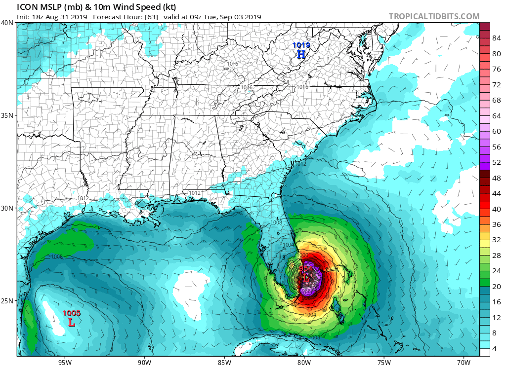
ATL: DORIAN - Models

Moderator: S2k Moderators

Message
Author
User avatar
mutley
S2K Supporter
S2K Supporter
Posts: 311
Joined: Wed Aug 15, 2007 7:18 am
Location: Gainesville, FL

Re: ATL: DORIAN - Models

#4941 Postby mutley » Sat Aug 31, 2019 4:22 pm

BobHarlem wrote:
mutley wrote:
PandaCitrus wrote:18z ICON German Global Model has Dorian landfalling in Ft. Lauderdale after a slow due west.


What does that model see so differently?


More influence from the low to the west. You can go all the back to 12z Tuesday before it gets wildly off from where Dorian is now.


Ah, in the gulf you mean. I see. Thanks.
1 likes   
The preceding comments are never to be used as information to establish circumstances, plans or procedures for any weather related events. Only use official National Hurricane Center or National Weather Service information issued for your area.

User avatar
gatorcane
S2K Supporter
S2K Supporter
Posts: 23691
Age: 47
Joined: Sun Mar 13, 2005 3:54 pm
Location: Boca Raton, FL

Re: ATL: DORIAN - Models

#4942 Postby gatorcane » Sat Aug 31, 2019 4:26 pm

MrJames wrote:12z UKM close up

https://i.imgur.com/ybNXoXm.png


How strong are those ensembles showing Dorian?
0 likes   

User avatar
mutley
S2K Supporter
S2K Supporter
Posts: 311
Joined: Wed Aug 15, 2007 7:18 am
Location: Gainesville, FL

Re: ATL: DORIAN - Models

#4943 Postby mutley » Sat Aug 31, 2019 4:28 pm

gatorcane wrote:18Z ICON has barely budged from its prior 12Z solution and would be catastrophic for metro SE Florida as it barely moves it up the coastline:

https://i.postimg.cc/nhFHGn3J/icon-mslp-wind-seus-22.png


This new german ICON model has two possible destinies. Greatness, or back to the model farm for more training, with it's head held low.
12 likes   
The preceding comments are never to be used as information to establish circumstances, plans or procedures for any weather related events. Only use official National Hurricane Center or National Weather Service information issued for your area.

Ian2401
Category 1
Category 1
Posts: 307
Joined: Thu Sep 14, 2017 5:55 pm
Location: Tallahassee, Florida
Contact:

Re: ATL: DORIAN - Models

#4944 Postby Ian2401 » Sat Aug 31, 2019 4:32 pm

mutley wrote:
gatorcane wrote:18Z ICON has barely budged from its prior 12Z solution and would be catastrophic for metro SE Florida as it barely moves it up the coastline:

https://i.postimg.cc/nhFHGn3J/icon-mslp-wind-seus-22.png


This new german ICON model has two possible destinies. Greatness, or back to the model farm for more training, with it's head held low.

its consistent ill give it that. something the other models cant say
2 likes   
B.S. Meteorology from Florida State '24 // Current M.S. Meteorology student at Florida State

Research Interests: Rapid Intensification, TC Climatology, TC Modeling

Consult the NHC for official information

Ian2401
Category 1
Category 1
Posts: 307
Joined: Thu Sep 14, 2017 5:55 pm
Location: Tallahassee, Florida
Contact:

Re: ATL: DORIAN - Models

#4945 Postby Ian2401 » Sat Aug 31, 2019 4:33 pm

18z GFS running. slightly faster at 6hr
0 likes   
B.S. Meteorology from Florida State '24 // Current M.S. Meteorology student at Florida State

Research Interests: Rapid Intensification, TC Climatology, TC Modeling

Consult the NHC for official information

brghteys1216
Tropical Storm
Tropical Storm
Posts: 118
Age: 35
Joined: Wed Aug 30, 2017 1:35 am

Re: ATL: DORIAN - Models

#4946 Postby brghteys1216 » Sat Aug 31, 2019 4:36 pm

For what it’s worth, ICON is showing that SW dip the UKMET models do.
1 likes   
Personal Forecast Disclaimer:
I'm just an enthusiast and weather fan and any comments I make are just my opinion and are NOT endorsed by any professional institution or storm2k.org. For official information, please refer to the NHC and NWS products.

sma10
Category 5
Category 5
Posts: 1710
Joined: Tue Aug 02, 2005 1:13 pm

Re: ATL: DORIAN - Models

#4947 Postby sma10 » Sat Aug 31, 2019 4:36 pm

Ian2401 wrote:
mutley wrote:
gatorcane wrote:18Z ICON has barely budged from its prior 12Z solution and would be catastrophic for metro SE Florida as it barely moves it up the coastline:

https://i.postimg.cc/nhFHGn3J/icon-mslp-wind-seus-22.png


This new german ICON model has two possible destinies. Greatness, or back to the model farm for more training, with it's head held low.

its consistent ill give it that. something the other models cant say


And also, because tensions are so heightened due to the effect on coastal residents, the understandable mood is that ICON's position is some kind of kooky, crazy outlier. It's not really. For a 72 hr position, it's left yes, but not outrageously so.
5 likes   

Ian2401
Category 1
Category 1
Posts: 307
Joined: Thu Sep 14, 2017 5:55 pm
Location: Tallahassee, Florida
Contact:

Re: ATL: DORIAN - Models

#4948 Postby Ian2401 » Sat Aug 31, 2019 4:38 pm

sma10 wrote:
Ian2401 wrote:
mutley wrote:
This new german ICON model has two possible destinies. Greatness, or back to the model farm for more training, with it's head held low.

its consistent ill give it that. something the other models cant say


And also, because tensions are so heightened due to the effect on coastal residents, the understandable mood is that ICON's position is some kind of kooky, crazy outlier. It's not really. For a 72 hr position, it's left yes, but not outrageously so.

that and its got support from the UKMET too. dont think they will verify but like you said its not an outrageous solution.
1 likes   
B.S. Meteorology from Florida State '24 // Current M.S. Meteorology student at Florida State

Research Interests: Rapid Intensification, TC Climatology, TC Modeling

Consult the NHC for official information

HurricaneFrances04
Category 2
Category 2
Posts: 597
Joined: Mon Jun 25, 2012 8:09 am
Location: Fort Lauderdale, Florida

Re: ATL: DORIAN - Models

#4949 Postby HurricaneFrances04 » Sat Aug 31, 2019 4:39 pm

On the 18Z GFS, ridging looks a bit stronger and the trough is a tad slower. Wouldn't be surprised if there is a small shift west here.
0 likes   

Ian2401
Category 1
Category 1
Posts: 307
Joined: Thu Sep 14, 2017 5:55 pm
Location: Tallahassee, Florida
Contact:

Re: ATL: DORIAN - Models

#4950 Postby Ian2401 » Sat Aug 31, 2019 4:40 pm

gfs has same latitude but faster forward speed. also looks like the ridge is a touch stronger
0 likes   
B.S. Meteorology from Florida State '24 // Current M.S. Meteorology student at Florida State

Research Interests: Rapid Intensification, TC Climatology, TC Modeling

Consult the NHC for official information

jlauderdal
S2K Supporter
S2K Supporter
Posts: 7183
Joined: Wed May 19, 2004 5:46 am
Location: NE Fort Lauderdale
Contact:

Re: RE: Re: ATL: DORIAN - Models

#4951 Postby jlauderdal » Sat Aug 31, 2019 4:41 pm

Ian2401 wrote:
sma10 wrote:
Ian2401 wrote:its consistent ill give it that. something the other models cant say


And also, because tensions are so heightened due to the effect on coastal residents, the understandable mood is that ICON's position is some kind of kooky, crazy outlier. It's not really. For a 72 hr position, it's left yes, but not outrageously so.

that and its got support from the UKMET too. dont think they will verify but like you said its not an outrageous solution.
We have seem ridges underestimated for years, we shouldn't discount its solution.
1 likes   

User avatar
Blown Away
S2K Supporter
S2K Supporter
Posts: 10147
Joined: Wed May 26, 2004 6:17 am

Re: ATL: DORIAN - Models

#4952 Postby Blown Away » Sat Aug 31, 2019 4:41 pm

Image

18z GFS...Trend
0 likes   
Hurricane Eye Experience: David 79, Irene 99, Frances 04, Jeanne 04, Wilma 05... EYE COMING MY WAY IN 2024…
Hurricane Brush Experience: Andrew 92, Erin 95, Floyd 99, Matthew 16, Irma 17, Ian 22, Nicole 22…

User avatar
StPeteMike
Category 2
Category 2
Posts: 631
Joined: Thu Jun 07, 2018 11:26 pm

Re: ATL: DORIAN - Models

#4953 Postby StPeteMike » Sat Aug 31, 2019 4:41 pm

It’s Irma all over again.
0 likes   
The above post is not official and should not be used as such. It is the opinion of the poster and may or may not be backed by sound meteorological data. It is not endorsed by any professional institution or storm2k.org. For official information, please refer to the NHC and NWS products.

HurricaneFrances04
Category 2
Category 2
Posts: 597
Joined: Mon Jun 25, 2012 8:09 am
Location: Fort Lauderdale, Florida

Re: ATL: DORIAN - Models

#4954 Postby HurricaneFrances04 » Sat Aug 31, 2019 4:43 pm

Actually, a bit more ridging on the 18Z GFS through 42 hours. This might be a coastal scraper for North Florida/Georgia
0 likes   

User avatar
Blown Away
S2K Supporter
S2K Supporter
Posts: 10147
Joined: Wed May 26, 2004 6:17 am

Re: ATL: DORIAN - Models

#4955 Postby Blown Away » Sat Aug 31, 2019 4:44 pm

Image

18z GFS... Trend
1 likes   
Hurricane Eye Experience: David 79, Irene 99, Frances 04, Jeanne 04, Wilma 05... EYE COMING MY WAY IN 2024…
Hurricane Brush Experience: Andrew 92, Erin 95, Floyd 99, Matthew 16, Irma 17, Ian 22, Nicole 22…

User avatar
chaser1
S2K Supporter
S2K Supporter
Posts: 5473
Age: 64
Joined: Sat Oct 15, 2005 5:59 pm
Location: Longwood, Fl

Re: ATL: DORIAN - Models

#4956 Postby chaser1 » Sat Aug 31, 2019 4:45 pm

Canelaw99 wrote:
PandaCitrus wrote:18z ICON German Global Model has Dorian landfalling in Ft. Lauderdale after a slow due west.

I would love for someone to compare the runs of the GICON (German ICON) to what the storm has been doing. It has hardly waivered from its track this whole time.[/qu

0Z Aug 30 ICON run showed a Ft. Lauderdale landfall at 120 hr's. Same model run took the storm to Tampa, and to Jacksonville from there. 12Z ICON model run more or less did the same. 18Z ICON run did the same (at least to Tampa due to being cut off at 120 hr. for this run). Seems to me that the issue with the ICON runs up to that point, were that it was too fast (moving the storm about 24 hours to the coastline quicker then other models).
4 likes   
Andy D

(For official information, please refer to the NHC and NWS products.)

User avatar
SEASON_CANCELED
Category 3
Category 3
Posts: 887
Joined: Mon Jul 06, 2009 5:17 am
Location: 8 Bit Charlie Sheen

Re: ATL: DORIAN - Models

#4957 Postby SEASON_CANCELED » Sat Aug 31, 2019 4:46 pm

StPeteMike wrote:It’s Irma all over again.


Ukmet nailed Irma 4 days before hand...all the other models had a matthew and middle of florida consensus

Hope its wrong
5 likes   
i am a big stupid ugly moron with an ugly face and a big butt and my butt stinks and i like to kiss my own butt

User avatar
mutley
S2K Supporter
S2K Supporter
Posts: 311
Joined: Wed Aug 15, 2007 7:18 am
Location: Gainesville, FL

Re: ATL: DORIAN - Models

#4958 Postby mutley » Sat Aug 31, 2019 4:47 pm

Ian2401 wrote:
sma10 wrote:
Ian2401 wrote:its consistent ill give it that. something the other models cant say


And also, because tensions are so heightened due to the effect on coastal residents, the understandable mood is that ICON's position is some kind of kooky, crazy outlier. It's not really. For a 72 hr position, it's left yes, but not outrageously so.

that and its got support from the UKMET too. dont think they will verify but like you said its not an outrageous solution.


I honestly don't think they will verify either, based on all I see. But if they do, it will be shocking to many. We will see. New royalty in the making (UKMET and ICON) or flash in the pan dunderheads. LOL.
Last edited by mutley on Sat Aug 31, 2019 4:48 pm, edited 1 time in total.
0 likes   
The preceding comments are never to be used as information to establish circumstances, plans or procedures for any weather related events. Only use official National Hurricane Center or National Weather Service information issued for your area.

User avatar
Blown Away
S2K Supporter
S2K Supporter
Posts: 10147
Joined: Wed May 26, 2004 6:17 am

Re: ATL: DORIAN - Models

#4959 Postby Blown Away » Sat Aug 31, 2019 4:48 pm

Image
18z GFS... Says heck with the stall scenario IMO... Way faster than NHC track
Last edited by Blown Away on Sat Aug 31, 2019 4:50 pm, edited 1 time in total.
0 likes   
Hurricane Eye Experience: David 79, Irene 99, Frances 04, Jeanne 04, Wilma 05... EYE COMING MY WAY IN 2024…
Hurricane Brush Experience: Andrew 92, Erin 95, Floyd 99, Matthew 16, Irma 17, Ian 22, Nicole 22…

User avatar
FLpanhandle91
Category 5
Category 5
Posts: 1033
Age: 34
Joined: Mon Sep 13, 2010 3:50 pm
Location: Fort Walton Beach, FL

Re: ATL: DORIAN - Models

#4960 Postby FLpanhandle91 » Sat Aug 31, 2019 4:49 pm

GFS trending a stronger ridge building back north of Dorian around hour 54. If this gets much stronger, I expect to see more members making landfall.
1 likes   


Return to “2019”

Who is online

Users browsing this forum: No registered users and 6 guests