ATL: DORIAN - Models
Moderator: S2k Moderators
-
HurricaneFrances04
- Category 2

- Posts: 597
- Joined: Mon Jun 25, 2012 8:09 am
- Location: Fort Lauderdale, Florida
Re: ATL: DORIAN - Models
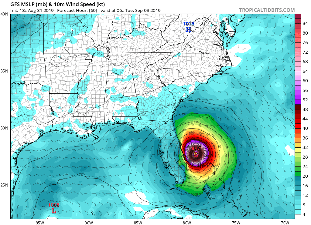
GFS stalls out at 54 to 60 hours. Suspect it will start heading NW/NNW once the ridge builds back in.
0 likes

Re: ATL: DORIAN - Models
SEASON_CANCELED wrote:StPeteMike wrote:It’s Irma all over again.
Ukmet nailed Irma 4 days before hand...all the other models had a matthew and middle of florida consensus
Hope its wrong
Can someone re-post the 12 UK from today?
1 likes
Andy D
(For official information, please refer to the NHC and NWS products.)
(For official information, please refer to the NHC and NWS products.)


Re: ATL: DORIAN - Models
Wow. Could be back to a Florida landfall here. Not much movement from 54 to 72 hours, maybe nnw
Last edited by funster on Sat Aug 31, 2019 4:54 pm, edited 1 time in total.
0 likes
Re: ATL: DORIAN - Models
Ironically, if you plot the models out, GFS is really almost as much a right outlier as ICON is a left outlier (at least at the 72 hr mark)
Last edited by sma10 on Sat Aug 31, 2019 4:53 pm, edited 1 time in total.
0 likes
-
Evil Jeremy

- S2K Supporter

- Posts: 5463
- Age: 32
- Joined: Mon Apr 10, 2006 2:10 pm
- Location: Los Angeles, CA
Re: ATL: DORIAN - Models
I'm going to attempt to do a validation check on the much discussed ICON.
Here is the 18z ICON 3 hrs out: https://www.tropicaltidbits.com/analysi ... watl_1.png
This is August 28 00z run, 93 hours out (to now): https://www.tropicaltidbits.com/analysi ... atl_31.png
Very on point. That run ends with a landfall in SE FL.
Pretty much all the ICON runs between that 8/28/00z and the most current have had Dorian pretty much in this current location in this time.
10 likes
Frances 04 / Jeanne 04 / Katrina 05 / Wilma 05 / Fay 08 / Debby 12 / Andrea 13 / Colin 16 / Hermine 16 / Matthew 16 / Irma 17
-
TheDreamTraveler

- Category 2
- Posts: 645
- Joined: Sun Aug 22, 2010 3:10 am
- Location: PA
Re: ATL: DORIAN - Models
Well that's interesting...I knew the models would shift back west and correct themselves after the extreme shift to the east.

0 likes


Re: ATL: DORIAN - Models
For like the 8th run in a row the GFS has underestimated 500mb heights to the north of the system within its 6 hour forecast. Think the Gonzo flight should help alleviate that for 0z hopefully.
4 likes
-
gatorcane

- S2K Supporter
- Posts: 23708
- Age: 48
- Joined: Sun Mar 13, 2005 3:54 pm
- Location: Boca Raton, FL
Re: ATL: DORIAN - Models
The GFS did shift west some on the 18Z on the turn. Hopefully it doesn’t keep shifting west.
1 likes
-
HurricaneFrances04
- Category 2
- Posts: 597
- Joined: Mon Jun 25, 2012 8:09 am
- Location: Fort Lauderdale, Florida

-
Blown Away

- S2K Supporter
- Posts: 10253
- Joined: Wed May 26, 2004 6:17 am
Re: ATL: DORIAN - Models

18z GFS... Definite W trend... Getting interesting again... If not Florida may make it harder to escape w/o impacts farther north...
1 likes
Hurricane Eye Experience: David 79, Irene 99, Frances 04, Jeanne 04, Wilma 05… Hurricane Brush Experience: Andrew 92, Erin 95, Floyd 99, Matthew 16, Irma 17, Ian 22, Nicole 22…
-
AutoPenalti
- Category 5

- Posts: 4091
- Age: 29
- Joined: Mon Aug 17, 2015 4:16 pm
- Location: Ft. Lauderdale, Florida
Re: ATL: DORIAN - Models
Definitely a role reversal from yesterday, still plenty of time for changes.
0 likes
The posts in this forum are NOT official forecasts and should not be used as such. They are just the opinion of the poster and may or may not be backed by sound meteorological data. They are NOT endorsed by any professional institution or STORM2K. For official information, please refer to products from the NHC and NWS.
Model Runs Cheat Sheet:
GFS (5:30 AM/PM, 11:30 AM/PM)
HWRF, GFDL, UKMET, NAVGEM (6:30-8:00 AM/PM, 12:30-2:00 AM/PM)
ECMWF (1:45 AM/PM)
TCVN is a weighted averaged
-
TheDreamTraveler
- Category 2
- Posts: 645
- Joined: Sun Aug 22, 2010 3:10 am
- Location: PA
Re: ATL: DORIAN - Models
This would explain a lot about the westward shift in the 18z GFS...
https://twitter.com/TropicalTidbits/status/1167916079995187200
https://twitter.com/TropicalTidbits/status/1167916079995187200
3 likes
-
gatorcane
- S2K Supporter
- Posts: 23708
- Age: 48
- Joined: Sun Mar 13, 2005 3:54 pm
- Location: Boca Raton, FL
Re: ATL: DORIAN - Models
AutoPenalti wrote:Definitely a role reversal from yesterday, still plenty of time for changes.
Wouldn’t take too many more shifts to have Dorian recurving into Palm Beach County. I keep thinking about Irma and what happened and all the west shifts literally up to landfall. Went from coastal SE Florida to the lower Keys in just a few days.
Last edited by gatorcane on Sat Aug 31, 2019 4:58 pm, edited 2 times in total.
2 likes
-
ConvergenceZone
.gif)
- Category 5
- Posts: 5241
- Joined: Fri Jul 29, 2005 1:40 am
- Location: Northern California
Re: ATL: DORIAN - Models
Thanks to those posting the model runs. Keep posting the GFS model maps. With the west shift, I'm curious if it will go a bit more inland once reaching the carolinas
Last edited by ConvergenceZone on Sat Aug 31, 2019 4:59 pm, edited 1 time in total.
1 likes
-
toad strangler

- S2K Supporter
- Posts: 4546
- Joined: Sun Jul 28, 2013 3:09 pm
- Location: Earth
- Contact:
Re: ATL: DORIAN - Models
18z GFS gives real TS conditions to much of the new watch area on the FL East Coast
Last edited by toad strangler on Sat Aug 31, 2019 5:00 pm, edited 1 time in total.
0 likes
My Weather Station
https://www.wunderground.com/dashboard/pws/KFLPORTS603
https://www.wunderground.com/dashboard/pws/KFLPORTS603
-
Blown Away
- S2K Supporter
- Posts: 10253
- Joined: Wed May 26, 2004 6:17 am
Re: ATL: DORIAN - Models
gatorcane wrote:The GFS did shift west some on the 18Z on the turn. Hopefully it doesn’t keep shifting west.
Some, that's a pretty big shift in short term. Also, GFS seems to not have much of a stall like Euro...
1 likes
Hurricane Eye Experience: David 79, Irene 99, Frances 04, Jeanne 04, Wilma 05… Hurricane Brush Experience: Andrew 92, Erin 95, Floyd 99, Matthew 16, Irma 17, Ian 22, Nicole 22…
-
Jevo

- S2K Supporter
- Posts: 1729
- Age: 47
- Joined: Tue Aug 03, 2004 8:45 pm
- Location: The Flemish Cap
- Contact:
Re: ATL: DORIAN - Models
Cmon GFS!  ... well this just got a bit disconcerting, especially since I just drove through Vero on the way home from Disney and shutters were coming down off businesses in a Publix plaza we stopped in.
Last edited by Jevo on Sat Aug 31, 2019 5:00 pm, edited 1 time in total.
1 likes
Disclaimer: 50% of the time I have no clue of what I am talking about. Chances are I am taking a less than educated guess that sounds good because 10 years ago I stole Mike Watkins book 'The Hurricane and its Impact'. For official information please direct yourself to the NHC and their cadre of weather geniuses.
-
FLpanhandle91

- Category 5
- Posts: 1039
- Age: 34
- Joined: Mon Sep 13, 2010 3:50 pm
- Location: Fort Walton Beach, FL
Re: ATL: DORIAN - Models
TheDreamTraveler wrote:This would explain a lot about the westward shift in the 18z GFS...
https://twitter.com/TropicalTidbits/status/1167916079995187200
I believe this data is not input into this run.
0 likes
Re: ATL: DORIAN - Models
gatorcane wrote:The GFS did shift west some on the 18Z on the turn. Hopefully it doesn’t keep shifting west.
Hard to nail down exactly but looking at the 18Z GFS run, i'd guess that Stuart north to Titusville would receive hurricane force gusts for a prolonged duration. Now, it IS the GFS Happy Hour run LOL, but then again ..... the model has been trending a bit further west and south over the past 2 runs
2 likes
Andy D
(For official information, please refer to the NHC and NWS products.)
(For official information, please refer to the NHC and NWS products.)
Who is online
Users browsing this forum: No registered users and 56 guests