
WPAC: HAGIBIS - Post-Tropical
Moderator: S2k Moderators
-
euro6208

Re: WPAC: HAGIBIS - Typhoon
Likely overestimated by 15-20 knots due to JTWC goofy protocol
20W HAGIBIS 191008 0000 16.9N 143.7E WPAC 135 921
0 likes
Very useful information on the Dvorak Technique --
https://severe.worldweather.wmo.int/TCF ... kBeven.pdf
https://severe.worldweather.wmo.int/TCF ... kBeven.pdf
-
euro6208
Re: WPAC: HAGIBIS - Typhoon
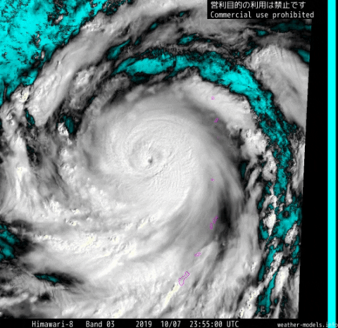
Amazing that a small volcanic island (indicated by a red pointing arrow) out of nowhere in the Pacific got smacked by a pinhole.

Last edited by euro6208 on Mon Oct 07, 2019 10:42 pm, edited 1 time in total.
2 likes
-
1900hurricane

- Category 5

- Posts: 6063
- Age: 34
- Joined: Fri Feb 06, 2015 12:04 pm
- Location: Houston, TX
- Contact:
Re: WPAC: HAGIBIS - Typhoon
Eyewall replacement appears to be moving along without much issue.


1 likes
Contract Meteorologist. TAMU & MSST. Fiercely authentic, one of a kind. We are all given free will, so choose a life meant to be lived. We are the Masters of our own Stories.
Opinions expressed are mine alone.
Follow me on Twitter at @1900hurricane : Read blogs at https://1900hurricane.wordpress.com/
Opinions expressed are mine alone.
Follow me on Twitter at @1900hurricane : Read blogs at https://1900hurricane.wordpress.com/
-
1900hurricane
- Category 5
- Posts: 6063
- Age: 34
- Joined: Fri Feb 06, 2015 12:04 pm
- Location: Houston, TX
- Contact:
Re: WPAC: HAGIBIS - Typhoon
Highteeld wrote:Likely overestimated by 15-20 knots due to JTWC goofy protocol20W HAGIBIS 191008 0000 16.9N 143.7E WPAC 135 921
Believe it or not, JTWC might actually be somewhat close to reality in this case. Data from Wilma '05 in particular showed that the max winds can drop considerably at first as core pressure gradient transitions and the outer eyewall begins to take over. That doesn't change the likely considerable underestimation earlier though.
2 likes
Contract Meteorologist. TAMU & MSST. Fiercely authentic, one of a kind. We are all given free will, so choose a life meant to be lived. We are the Masters of our own Stories.
Opinions expressed are mine alone.
Follow me on Twitter at @1900hurricane : Read blogs at https://1900hurricane.wordpress.com/
Opinions expressed are mine alone.
Follow me on Twitter at @1900hurricane : Read blogs at https://1900hurricane.wordpress.com/
Re: WPAC: HAGIBIS - Typhoon
Highteeld wrote:https://www.nrlmry.navy.mil//tcdat/tc2019/WP/WP202019/png/Infrared/himawari8/201910071020_WP202019_ahi_himawari8_Infrared_130.0_covg100p0_res1km.png
https://www.nrlmry.navy.mil/tcdat/tc15/EPAC/20E.PATRICIA/ir/ols/1km/20151023.1344.f19.x.ir1km.20EPATRICIA.175kts-880mb-172N-1056W.100pc.jpg
https://www.nrlmry.navy.mil/tcdat/tc05/ATL/25L.WILMA/ir/ols/1km/20051019.1233.f14.x.ir1km.25LWILMA.150kts-882mb-173N-828W.jpg
Edited for better resolution:

0 likes
Very useful information on the Dvorak Technique --
https://severe.worldweather.wmo.int/TCF ... kBeven.pdf
https://severe.worldweather.wmo.int/TCF ... kBeven.pdf
Re: WPAC: HAGIBIS - Typhoon
1900hurricane wrote:Highteeld wrote:Likely overestimated by 15-20 knots due to JTWC goofy protocol20W HAGIBIS 191008 0000 16.9N 143.7E WPAC 135 921
Believe it or not, JTWC might actually be somewhat close to reality in this case. Data from Wilma '05 in particular showed that the max winds can drop considerably at first as core pressure gradient transitions and the outer eyewall begins to take over. That doesn't change the likely considerable underestimation earlier though.
135 knots would be pretty phenomenal at this point, but I guess it's possible.
0 likes
Very useful information on the Dvorak Technique --
https://severe.worldweather.wmo.int/TCF ... kBeven.pdf
https://severe.worldweather.wmo.int/TCF ... kBeven.pdf
Re: WPAC: HAGIBIS - Typhoon
Highteeld wrote:Highteeld wrote:https://www.nrlmry.navy.mil//tcdat/tc2019/WP/WP202019/png/Infrared/himawari8/201910071020_WP202019_ahi_himawari8_Infrared_130.0_covg100p0_res1km.png
https://www.nrlmry.navy.mil/tcdat/tc15/EPAC/20E.PATRICIA/ir/ols/1km/20151023.1344.f19.x.ir1km.20EPATRICIA.175kts-880mb-172N-1056W.100pc.jpg
https://www.nrlmry.navy.mil/tcdat/tc05/ATL/25L.WILMA/ir/ols/1km/20051019.1233.f14.x.ir1km.25LWILMA.150kts-882mb-173N-828W.jpg
Edited for better resolution:
https://www.nrlmry.navy.mil//tcdat/tc2019/WP/WP202019/png/Infrared/himawari8/201910071020_WP202019_ahi_himawari8_Infrared_130.0_covg100p0_res1km.png
1040z is pretty violent too:

0 likes
Very useful information on the Dvorak Technique --
https://severe.worldweather.wmo.int/TCF ... kBeven.pdf
https://severe.worldweather.wmo.int/TCF ... kBeven.pdf
Re: WPAC: HAGIBIS - Typhoon
1900hurricane wrote:Highteeld wrote:Likely overestimated by 15-20 knots due to JTWC goofy protocol20W HAGIBIS 191008 0000 16.9N 143.7E WPAC 135 921
Believe it or not, JTWC might actually be somewhat close to reality in this case. Data from Wilma '05 in particular showed that the max winds can drop considerably at first as core pressure gradient transitions and the outer eyewall begins to take over. That doesn't change the likely considerable underestimation earlier though.
One other question I have is this: does that apply to sfc winds or FL? IIRC, Wilma was before the time of SFMR, so the way we measured that storm may not yield the same results as current protocol. IDK, just thinking out loud... just seems like SFMR and FL winds have a bigger gap during ERC's, while the gap is very small to nil during RI phases (assuming we believe SFMR is a decent benchmark, that is). All anecdotal on my behalf.
0 likes
Very useful information on the Dvorak Technique --
https://severe.worldweather.wmo.int/TCF ... kBeven.pdf
https://severe.worldweather.wmo.int/TCF ... kBeven.pdf
Re: WPAC: HAGIBIS - Typhoon
Moat grows 

0 likes
Very useful information on the Dvorak Technique --
https://severe.worldweather.wmo.int/TCF ... kBeven.pdf
https://severe.worldweather.wmo.int/TCF ... kBeven.pdf
-
Tailspin
Re: WPAC: HAGIBIS - Typhoon

https://imgur.com/WDaqSHN
Looks like maybe there some subsidence going on in the RFQ. Wonder's if it the begining
of a centre collapse.¯\_(ツ)_/¯.
0 likes
-
1900hurricane
- Category 5
- Posts: 6063
- Age: 34
- Joined: Fri Feb 06, 2015 12:04 pm
- Location: Houston, TX
- Contact:
Re: WPAC: HAGIBIS - Typhoon
Highteeld wrote:1900hurricane wrote:Highteeld wrote:Likely overestimated by 15-20 knots due to JTWC goofy protocol20W HAGIBIS 191008 0000 16.9N 143.7E WPAC 135 921
Believe it or not, JTWC might actually be somewhat close to reality in this case. Data from Wilma '05 in particular showed that the max winds can drop considerably at first as core pressure gradient transitions and the outer eyewall begins to take over. That doesn't change the likely considerable underestimation earlier though.
One other question I have is this: does that apply to sfc winds or FL? IIRC, Wilma was before the time of SFMR, so the way we measured that storm may not yield the same results as current protocol. IDK, just thinking out loud... just seems like SFMR and FL winds have a bigger gap during ERC's, while the gap is very small to nil during RI phases (assuming we believe SFMR is a decent benchmark, that is). All anecdotal on my behalf.
Both I think, although the data set is rather small. After Wilma '05, Maria '17 just prior to landfall in the Puerto Rico is probably the best sampled eyewall replacement similar to this one. Both SFMR data and flight level winds significantly dropped while the outer eyewall transitioned to the primary eyewall. NHC best track doesn't show this change particularly well (partially due to the coarse nature of best track points six hours apart), but the recon data did. I think it's pretty likely that we've dropped all the way down to 130-140 kt from something like 170 kt earlier, with the exact wind dependent on how low the pressure actually dropped.
Not sure how well I said what I wanted to say there, I'm a little scatterbrained today. : P
0 likes
Contract Meteorologist. TAMU & MSST. Fiercely authentic, one of a kind. We are all given free will, so choose a life meant to be lived. We are the Masters of our own Stories.
Opinions expressed are mine alone.
Follow me on Twitter at @1900hurricane : Read blogs at https://1900hurricane.wordpress.com/
Opinions expressed are mine alone.
Follow me on Twitter at @1900hurricane : Read blogs at https://1900hurricane.wordpress.com/
Re: WPAC: HAGIBIS - Typhoon
1900hurricane wrote:Highteeld wrote:1900hurricane wrote:Believe it or not, JTWC might actually be somewhat close to reality in this case. Data from Wilma '05 in particular showed that the max winds can drop considerably at first as core pressure gradient transitions and the outer eyewall begins to take over. That doesn't change the likely considerable underestimation earlier though.
One other question I have is this: does that apply to sfc winds or FL? IIRC, Wilma was before the time of SFMR, so the way we measured that storm may not yield the same results as current protocol. IDK, just thinking out loud... just seems like SFMR and FL winds have a bigger gap during ERC's, while the gap is very small to nil during RI phases (assuming we believe SFMR is a decent benchmark, that is). All anecdotal on my behalf.
Both I think, although the data set is rather small. After Wilma '05, Maria '17 just prior to landfall in the Puerto Rico is probably the best sampled eyewall replacement similar to this one. Both SFMR data and flight level winds significantly dropped while the outer eyewall transitioned to the primary eyewall. NHC best track doesn't show this change particularly well (partially due to the coarse nature of best track points six hours apart), but the recon data did. I think it's pretty likely that we've dropped all the way down to 130-140 kt from something like 170 kt earlier, with the exact wind dependent on how low the pressure actually dropped.
Not sure how well I said what I wanted to say there, I'm a little scatterbrained today. : P
I guess what I'm suggesting is maybe the typical FL to SFC ratio of .85 might more like this: .9 -- 1 to 1 ratio (RI Phase), while a .75 -- .85 FL to SFC ratio (ERC phase) might be accurate. All of this is hard to quantify, though, since as you said, the data set is not large. I think Lorenzo during its first ERC had something like FL of 103 knots with SFMR of 77 knots (not counting high SFMR bias here) to yield a ratio of around ~.75... while Dorian during RI, by contrast, had 161 knots FL, and 177 knot SFMR (reduced to 160 knots due to bias), which would be a much larger ratio, nearly 1 to 1.
0 likes
Very useful information on the Dvorak Technique --
https://severe.worldweather.wmo.int/TCF ... kBeven.pdf
https://severe.worldweather.wmo.int/TCF ... kBeven.pdf
Re: WPAC: HAGIBIS - Typhoon
Highteeld wrote:1900hurricane wrote:Highteeld wrote:One other question I have is this: does that apply to sfc winds or FL? IIRC, Wilma was before the time of SFMR, so the way we measured that storm may not yield the same results as current protocol. IDK, just thinking out loud... just seems like SFMR and FL winds have a bigger gap during ERC's, while the gap is very small to nil during RI phases (assuming we believe SFMR is a decent benchmark, that is). All anecdotal on my behalf.
Both I think, although the data set is rather small. After Wilma '05, Maria '17 just prior to landfall in the Puerto Rico is probably the best sampled eyewall replacement similar to this one. Both SFMR data and flight level winds significantly dropped while the outer eyewall transitioned to the primary eyewall. NHC best track doesn't show this change particularly well (partially due to the coarse nature of best track points six hours apart), but the recon data did. I think it's pretty likely that we've dropped all the way down to 130-140 kt from something like 170 kt earlier, with the exact wind dependent on how low the pressure actually dropped.
Not sure how well I said what I wanted to say there, I'm a little scatterbrained today. : P
I guess what I'm suggesting is maybe the typical FL to SFC ratio of .85 might more like this: .9 -- 1 to 1 ratio (RI Phase), while a .75 -- .85 FL to SFC ratio (ERC phase) might be accurate. All of this is hard to quantify, though, since as you said, the data set is not large. I think Lorenzo during its first ERC had something like FL of 103 knots with SFMR of 77 knots (not counting high SFMR bias here) to yield a ratio of around ~.75... while Dorian during RI, by contrast, had 161 knots FL, and 177 knot SFMR (reduced to 160 knots due to bias), which would be a much larger ratio, nearly 1 to 1.
Just to make this more confusing and anecdotal


0 likes
Very useful information on the Dvorak Technique --
https://severe.worldweather.wmo.int/TCF ... kBeven.pdf
https://severe.worldweather.wmo.int/TCF ... kBeven.pdf
Re: WPAC: HAGIBIS - Typhoon
Inner eyewall continues to erode:

0 likes
Very useful information on the Dvorak Technique --
https://severe.worldweather.wmo.int/TCF ... kBeven.pdf
https://severe.worldweather.wmo.int/TCF ... kBeven.pdf
Re: WPAC: HAGIBIS - Typhoon
Highteeld wrote:Inner eyewall continues to erode:
https://i.imgur.com/ipsU5S9.png
Last one for a bit:
0 likes
Very useful information on the Dvorak Technique --
https://severe.worldweather.wmo.int/TCF ... kBeven.pdf
https://severe.worldweather.wmo.int/TCF ... kBeven.pdf

Re: WPAC: HAGIBIS - Typhoon

1 likes
ヤンデレ女が寝取られるているのを見たい!!!
ECMWF ensemble NWPAC plots: https://ecmwfensnwpac.imgbb.com/
Multimodel NWPAC plots: https://multimodelnwpac.imgbb.com/
GFS Ensemble NWPAC plots (16 & 35 day forecast): https://gefsnwpac.imgbb.com/
Plots updated automatically
ECMWF ensemble NWPAC plots: https://ecmwfensnwpac.imgbb.com/
Multimodel NWPAC plots: https://multimodelnwpac.imgbb.com/
GFS Ensemble NWPAC plots (16 & 35 day forecast): https://gefsnwpac.imgbb.com/
Plots updated automatically
Re: WPAC: HAGIBIS - Typhoon
20W HAGIBIS 191008 0600 17.7N 142.6E WPAC 135 920
0 likes
Very useful information on the Dvorak Technique --
https://severe.worldweather.wmo.int/TCF ... kBeven.pdf
https://severe.worldweather.wmo.int/TCF ... kBeven.pdf

Re: WPAC: HAGIBIS - Typhoon
6Z GFS is earlier than the usual 930Z start time today.
0 likes
ヤンデレ女が寝取られるているのを見たい!!!
ECMWF ensemble NWPAC plots: https://ecmwfensnwpac.imgbb.com/
Multimodel NWPAC plots: https://multimodelnwpac.imgbb.com/
GFS Ensemble NWPAC plots (16 & 35 day forecast): https://gefsnwpac.imgbb.com/
Plots updated automatically
ECMWF ensemble NWPAC plots: https://ecmwfensnwpac.imgbb.com/
Multimodel NWPAC plots: https://multimodelnwpac.imgbb.com/
GFS Ensemble NWPAC plots (16 & 35 day forecast): https://gefsnwpac.imgbb.com/
Plots updated automatically
Who is online
Users browsing this forum: No registered users and 21 guests