
WPAC: HAGIBIS - Post-Tropical
Moderator: S2k Moderators

Re: WPAC: HAGIBIS - Typhoon
JTWC will either maintain 140 or go >= 145
0 likes
ヤンデレ女が寝取られるているのを見たい!!!
ECMWF ensemble NWPAC plots: https://ecmwfensnwpac.imgbb.com/
Multimodel NWPAC plots: https://multimodelnwpac.imgbb.com/
GFS Ensemble NWPAC plots (16 & 35 day forecast): https://gefsnwpac.imgbb.com/
Plots updated automatically
ECMWF ensemble NWPAC plots: https://ecmwfensnwpac.imgbb.com/
Multimodel NWPAC plots: https://multimodelnwpac.imgbb.com/
GFS Ensemble NWPAC plots (16 & 35 day forecast): https://gefsnwpac.imgbb.com/
Plots updated automatically

Re: WPAC: HAGIBIS - Typhoon
Remained at 140, dropped 1 mb.
20W HAGIBIS 191009 0000 19.8N 140.3E WPAC 140 908
0 likes
Very useful information on the Dvorak Technique --
https://severe.worldweather.wmo.int/TCF ... kBeven.pdf
https://severe.worldweather.wmo.int/TCF ... kBeven.pdf
-
1900hurricane

- Category 5

- Posts: 6063
- Age: 34
- Joined: Fri Feb 06, 2015 12:04 pm
- Location: Houston, TX
- Contact:
Re: WPAC: HAGIBIS - Typhoon
I think 140 kt is ok again for 00Z. Microwave estimates are all higher (around 155 kt actually), but 89 GHz imagery reveals a weak outer eyewall feature just outside the primary eyewall. With how weak and close in to the primary eyewall it is, it might be a meld candidate, but it's probably keeping the winds a little lower than they would be otherwise. Visible imagery looks slightly skeletal vs the large CDO seen earlier, so that's another hint of that feature.


0 likes
Contract Meteorologist. TAMU & MSST. Fiercely authentic, one of a kind. We are all given free will, so choose a life meant to be lived. We are the Masters of our own Stories.
Opinions expressed are mine alone.
Follow me on Twitter at @1900hurricane : Read blogs at https://1900hurricane.wordpress.com/
Opinions expressed are mine alone.
Follow me on Twitter at @1900hurricane : Read blogs at https://1900hurricane.wordpress.com/
-
euro6208
Re: WPAC: HAGIBIS - Typhoon
Seems like Hagibis cannot go above 140 knots  Utterly fail by satellite estimates.
0 likes
Re: WPAC: HAGIBIS - Typhoon
Eye temperature starting to notably increase. Wouldn't be surprised if it's near 19*C at the 110z ADT analysis.

0 likes
Very useful information on the Dvorak Technique --
https://severe.worldweather.wmo.int/TCF ... kBeven.pdf
https://severe.worldweather.wmo.int/TCF ... kBeven.pdf
Re: WPAC: HAGIBIS - Typhoon
Highteeld wrote:Eye temperature starting to notably increase. Wouldn't be surprised if it's near 19*C at the 110z ADT analysis.
https://i.imgur.com/8etPK8Q.png
Modest increase
2019OCT09 011000 6.9 907.9 137.4 6.6 6.6 6.6 NO LIMIT ON OFF OFF OFF 18.41 -71.87 EYE 30 IR 68.8 19.98 -140.28 ARCHER HIM-8 23.4
0 likes
Very useful information on the Dvorak Technique --
https://severe.worldweather.wmo.int/TCF ... kBeven.pdf
https://severe.worldweather.wmo.int/TCF ... kBeven.pdf
-
1900hurricane
- Category 5
- Posts: 6063
- Age: 34
- Joined: Fri Feb 06, 2015 12:04 pm
- Location: Houston, TX
- Contact:
Re: WPAC: HAGIBIS - Typhoon
Reminds me quite a bit of peak Trami '18 right now.
0 likes
Contract Meteorologist. TAMU & MSST. Fiercely authentic, one of a kind. We are all given free will, so choose a life meant to be lived. We are the Masters of our own Stories.
Opinions expressed are mine alone.
Follow me on Twitter at @1900hurricane : Read blogs at https://1900hurricane.wordpress.com/
Opinions expressed are mine alone.
Follow me on Twitter at @1900hurricane : Read blogs at https://1900hurricane.wordpress.com/
Re: WPAC: HAGIBIS - Typhoon

0 likes
Very useful information on the Dvorak Technique --
https://severe.worldweather.wmo.int/TCF ... kBeven.pdf
https://severe.worldweather.wmo.int/TCF ... kBeven.pdf

Re: WPAC: HAGIBIS - Typhoon
Highteeld wrote:Eye temperature starting to notably increase. Wouldn't be surprised if it's near 19*C at the 110z ADT analysis.
https://i.imgur.com/8etPK8Q.png
That is a damned symmetrical donut shape. Could rapidly deepen overnight and get a full CDG ring again. Storms that have "the look" tend to be ready to go nuclear. Weird to talk about a 140kt storm getting ready to go nuts, but hey, that's the WPAC for you.
0 likes
-
euro6208
Re: WPAC: HAGIBIS - Typhoon
WDPN31 PGTW 090300
MSGID/GENADMIN/JOINT TYPHOON WRNCEN PEARL HARBOR HI//
SUBJ/PROGNOSTIC REASONING FOR SUPER TYPHOON 20W (HAGIBIS) WARNING NR
016//
RMKS/
1. FOR METEOROLOGISTS.
2. 6 HOUR SUMMARY AND ANALYSIS.
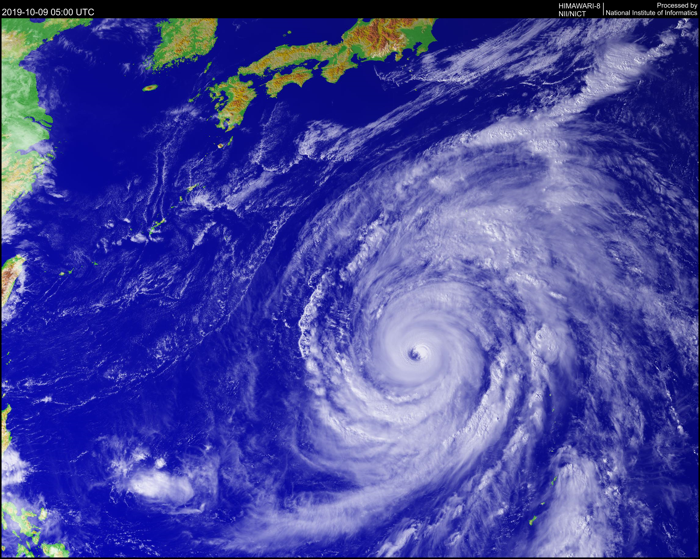
SUPER TYPHOON (STY) 20W (HAGIBIS), LOCATED APPROXIMATELY 305 NM
SOUTH OF IWO TO, HAS TRACKED NORTHWESTWARD AT 08 KNOTS (KTS) OVER THE
PAST SIX HOURS. ANIMATED MULTISPECTRAL SATELLITE IMAGERY (MSI)
DEPICTS A WELL-DEFINED, SYMMETRIC EYE WITH CONVECTIVE BANDING
WRAPPING INTO THE CENTER. STY 20W HAS MAINTAINED A 20 NM DIAMETER
EYE, SUPPORTING GOOD CONFIDENCE IN THE INITIAL POSITION. HOWEVER, THE
IMMEDIATE EXTENT OF THE CIRRUS SHIELD HAS DECREASED IN THE PAST SIX
HOURS. THE INITIAL INTENSITY IS SET AT 140 KTS WITH FAIR CONFIDENCE
BASED ON DVORAK CURRENT INTENSITY (CI) ESTIMATES OF T7.0/140 KTS FROM
PGTW/RJTD/RCTP ALONG WITH A 090033Z SATELLITE CONSENSUS OF 152 KTS
AND A 090110Z ADVANCED DVORAK TECHNIQUE (ADT) ESTIMATE OF T6.9/137
KTS. UPPER-LEVEL ANALYSIS SHOWS EXCELLENT EQUATORWARD AND EASTWARD
OUTFLOW WITH DEVELOPMENT OF A POLEWARD OUTFLOW CHANNEL AS A TROUGH
PASSES TO THE NORTH. THE OVERALL ENVIRONMENT REMAINS FAVORABLE FOR
BRIEF DEVELOPMENT WITH LOW (10-15 KTS) VERTICAL WIND SHEAR (VWS) AND
WARM (29-31 CELSIUS) SEA SURFACE TEMPERATURES (SST). TRACKING
NORTH-NORTHWESTWARD, STY 20W IS BEING STEERED BY A SUBTROPICAL RIDGE
(STR) TO THE NORTHEAST.
3. FORECAST REASONING.
A. THERE IS NO SIGNIFICANT CHANGE TO THE FORECAST PHILOSOPHY FROM
THE LAST PROGNOSTIC REASONING MESSAGE.
B. STY 20W WILL CONTINUE ALONG ITS NORTH-NORTHWESTWARD TRACK AS A
PASSING MID-LATITUDE TROUGH TO THE NORTH CAUSES THE STR TO REORIENT.
THE FAVORABLE ENVIRONMENT IS EXPECTED TO PERSIST WITH LOW VWS, WARM
SST, AND STRONG UPPER-LEVEL OUTFLOW. THE OFFICIAL INTENSITY FORECAST
REMAINS MORE AGGRESSIVE THAN MULTI-MODEL INTENSITY GUIDANCE DUE TO
THE POSSIBILITY OF A BRIEF PERIOD OF ENHANCED POLEWARD OUTFLOW AS A
RESULT OF INTERACTION WITH THE PASSING TROUGH. HOWEVER, AS THE
OUTFLOW BEGINS TO BE SHEARED BY THE PASSING TROUGH, GRADUAL WEAKENING
IS EXPECTED. THROUGH TAU 36, NUMERICAL MODELS REMAIN IN GOOD
AGREEMENT. GFS AND THE GFS ENSEMBLE REMAIN THE EASTERNMOST OUTLIERS
WITH NAVGEM AND AFUM AS THE WESTERNMOST OUTLIERS. AT TAU 72, THERE IS
190 NM OF CROSS-TRACK AND 200 NM OF ALONG-TRACK SPREAD AS THE MODEL
SOLUTIONS DIFFER IN TIMING OF RECURVATURE. PLACED NEAR THE
MULTI-MODEL CONSENSUS, THERE IS GOOD CONFIDENCE IN THE OFFICIAL JTWC
FORECAST IN THIS PORTION OF THE TRACK.
C. IN THE EXTENDED FORECAST PERIOD, STY 20W WILL BEGIN TO RECURVE
AS A SHORTWAVE TROUGH PASSES OVER JAPAN, WEAKENING THE STR. AS VWS
INCREASES AND SST COOL AFTER TAU 72, THE SYSTEM WILL CONTINUE TO
SLOWLY WEAKEN AS IT APPROACHES HONSHU. AS STY 20W TRACKS OVER LAND,
FRICTIONAL TERRAIN EFFECTS WILL ALSO BEGIN TO ERODE THE SYSTEM. STY
20W WILL BEGIN INTERACTING WITH THE TROUGH AROUND TAU 96,
ACCELERATING NORTHEASTWARD AS EXTRATROPICAL TRANSITION OCCURS. BY TAU
120, THE SYSTEM WILL BE FULLY EXTRATROPICAL AND EMBEDDED IN THE
MID-LATITUDE WESTERLIES. NUMERICAL MODELS ARE IN FAIR CROSS-TRACK
AGREEMENT AFTER RECURVATURE OF STY 20W. HOWEVER, AS THE SYSTEM
ACCELERATES, ALONG-TRACK SPREAD GREATLY INCREASES THROUGH TAU 120.
THE JTWC FORECAST TRACK IS PLACED NEAR THE MULTI-MODEL CONSENSUS;
BASED ON THE VARIATION IN MODEL TIMING OF THE RECURVE AND ALONG-TRACK
SPEEDS, THERE IS LOW CONFIDENCE IN THIS PORTION OF THE JTWC TRACK
FORECAST.//
NNNN
MSGID/GENADMIN/JOINT TYPHOON WRNCEN PEARL HARBOR HI//
SUBJ/PROGNOSTIC REASONING FOR SUPER TYPHOON 20W (HAGIBIS) WARNING NR
016//
RMKS/
1. FOR METEOROLOGISTS.
2. 6 HOUR SUMMARY AND ANALYSIS.
SUPER TYPHOON (STY) 20W (HAGIBIS), LOCATED APPROXIMATELY 305 NM
SOUTH OF IWO TO, HAS TRACKED NORTHWESTWARD AT 08 KNOTS (KTS) OVER THE
PAST SIX HOURS. ANIMATED MULTISPECTRAL SATELLITE IMAGERY (MSI)
DEPICTS A WELL-DEFINED, SYMMETRIC EYE WITH CONVECTIVE BANDING
WRAPPING INTO THE CENTER. STY 20W HAS MAINTAINED A 20 NM DIAMETER
EYE, SUPPORTING GOOD CONFIDENCE IN THE INITIAL POSITION. HOWEVER, THE
IMMEDIATE EXTENT OF THE CIRRUS SHIELD HAS DECREASED IN THE PAST SIX
HOURS. THE INITIAL INTENSITY IS SET AT 140 KTS WITH FAIR CONFIDENCE
BASED ON DVORAK CURRENT INTENSITY (CI) ESTIMATES OF T7.0/140 KTS FROM
PGTW/RJTD/RCTP ALONG WITH A 090033Z SATELLITE CONSENSUS OF 152 KTS
AND A 090110Z ADVANCED DVORAK TECHNIQUE (ADT) ESTIMATE OF T6.9/137
KTS. UPPER-LEVEL ANALYSIS SHOWS EXCELLENT EQUATORWARD AND EASTWARD
OUTFLOW WITH DEVELOPMENT OF A POLEWARD OUTFLOW CHANNEL AS A TROUGH
PASSES TO THE NORTH. THE OVERALL ENVIRONMENT REMAINS FAVORABLE FOR
BRIEF DEVELOPMENT WITH LOW (10-15 KTS) VERTICAL WIND SHEAR (VWS) AND
WARM (29-31 CELSIUS) SEA SURFACE TEMPERATURES (SST). TRACKING
NORTH-NORTHWESTWARD, STY 20W IS BEING STEERED BY A SUBTROPICAL RIDGE
(STR) TO THE NORTHEAST.
3. FORECAST REASONING.
A. THERE IS NO SIGNIFICANT CHANGE TO THE FORECAST PHILOSOPHY FROM
THE LAST PROGNOSTIC REASONING MESSAGE.
B. STY 20W WILL CONTINUE ALONG ITS NORTH-NORTHWESTWARD TRACK AS A
PASSING MID-LATITUDE TROUGH TO THE NORTH CAUSES THE STR TO REORIENT.
THE FAVORABLE ENVIRONMENT IS EXPECTED TO PERSIST WITH LOW VWS, WARM
SST, AND STRONG UPPER-LEVEL OUTFLOW. THE OFFICIAL INTENSITY FORECAST
REMAINS MORE AGGRESSIVE THAN MULTI-MODEL INTENSITY GUIDANCE DUE TO
THE POSSIBILITY OF A BRIEF PERIOD OF ENHANCED POLEWARD OUTFLOW AS A
RESULT OF INTERACTION WITH THE PASSING TROUGH. HOWEVER, AS THE
OUTFLOW BEGINS TO BE SHEARED BY THE PASSING TROUGH, GRADUAL WEAKENING
IS EXPECTED. THROUGH TAU 36, NUMERICAL MODELS REMAIN IN GOOD
AGREEMENT. GFS AND THE GFS ENSEMBLE REMAIN THE EASTERNMOST OUTLIERS
WITH NAVGEM AND AFUM AS THE WESTERNMOST OUTLIERS. AT TAU 72, THERE IS
190 NM OF CROSS-TRACK AND 200 NM OF ALONG-TRACK SPREAD AS THE MODEL
SOLUTIONS DIFFER IN TIMING OF RECURVATURE. PLACED NEAR THE
MULTI-MODEL CONSENSUS, THERE IS GOOD CONFIDENCE IN THE OFFICIAL JTWC
FORECAST IN THIS PORTION OF THE TRACK.
C. IN THE EXTENDED FORECAST PERIOD, STY 20W WILL BEGIN TO RECURVE
AS A SHORTWAVE TROUGH PASSES OVER JAPAN, WEAKENING THE STR. AS VWS
INCREASES AND SST COOL AFTER TAU 72, THE SYSTEM WILL CONTINUE TO
SLOWLY WEAKEN AS IT APPROACHES HONSHU. AS STY 20W TRACKS OVER LAND,
FRICTIONAL TERRAIN EFFECTS WILL ALSO BEGIN TO ERODE THE SYSTEM. STY
20W WILL BEGIN INTERACTING WITH THE TROUGH AROUND TAU 96,
ACCELERATING NORTHEASTWARD AS EXTRATROPICAL TRANSITION OCCURS. BY TAU
120, THE SYSTEM WILL BE FULLY EXTRATROPICAL AND EMBEDDED IN THE
MID-LATITUDE WESTERLIES. NUMERICAL MODELS ARE IN FAIR CROSS-TRACK
AGREEMENT AFTER RECURVATURE OF STY 20W. HOWEVER, AS THE SYSTEM
ACCELERATES, ALONG-TRACK SPREAD GREATLY INCREASES THROUGH TAU 120.
THE JTWC FORECAST TRACK IS PLACED NEAR THE MULTI-MODEL CONSENSUS;
BASED ON THE VARIATION IN MODEL TIMING OF THE RECURVE AND ALONG-TRACK
SPEEDS, THERE IS LOW CONFIDENCE IN THIS PORTION OF THE JTWC TRACK
FORECAST.//
NNNN
0 likes
Re: WPAC: HAGIBIS - Typhoon
SUPER TYPHOON 20W
Wednesday 09oct19 Time: 0033 UTC
Latitude: 19.85 Longitude: 140.25
Storm position corresponds to AMSU-A FOV 9 [1<--->30]
-----------------------------------------------------------------
| Estimated MSLP: 892 hPa
| Estimated Maximum Sustained Wind: 161 kts
| Estimate Confidence: Good ( +/- 10mb +/- 12kts )
-----------------------------------------------------------------
Storm is sub-sampled: Bias correction applied is -8.1 hPa
Channel 8 (~150 hPa) Tb Anomaly: 6.68
Channel 7 (~250 hPa) Tb Anomaly: 6.61
RMW: 23 km
RMW Source is: MW
Environmental Pressure: 1001
Satellite: NOAA-90
ATCF data for Month: 10 Day: 09 Time (UTC): 0000
RMW likely too small.


0 likes
Very useful information on the Dvorak Technique --
https://severe.worldweather.wmo.int/TCF ... kBeven.pdf
https://severe.worldweather.wmo.int/TCF ... kBeven.pdf
-
euro6208
Re: WPAC: HAGIBIS - Typhoon
CURRENT ESTIMATE
Date (mmddhhmm): 10090033
SATCON: MSLP = 899 hPa MSW = 154 knots
SATCON Member Consensus: 149.0 knots
Pressure -> Wind Using SATCON MSLP: 136 knots
Distance to Outer Closed Isobar Used is 230 nm
Eye Size Correction Used is -2.6 knots Source: IR
Member Estimates
ADT: 910 hPa 135 knots Scene: CDO Date: OCT090310
CIMSS AMSU: 892 hPa 161 knots Bias Corr: 0 (MW) Date: 10090033
ATMS: 927.8 hPa 124.5 knots Date: 10080414
SSMIS: 893.0 hPa 155.0 knots Date: 10082139
CIRA ATMS: 939 hPa 111 knots Date: 10071616
0 likes
-
euro6208
Re: WPAC: HAGIBIS - Typhoon
At least 150 knots if they decide to ignore dvorak. Dvorak does poor with systems like this.
0 likes
Re: WPAC: HAGIBIS - Typhoon
20W HAGIBIS 191009 0600 20.7N 139.9E WPAC 140 909
0 likes
Very useful information on the Dvorak Technique --
https://severe.worldweather.wmo.int/TCF ... kBeven.pdf
https://severe.worldweather.wmo.int/TCF ... kBeven.pdf
Re: WPAC: HAGIBIS - Typhoon
0 likes
Personal Forecast Disclaimer:
The posts in this forum are NOT official forecast and should not be used as such. They are just the opinion of the poster and may or may not be backed by sound meteorological data. They are NOT endorsed by any professional institution or storm2k.org. For official information, please refer to RSMC and NWS products.
The posts in this forum are NOT official forecast and should not be used as such. They are just the opinion of the poster and may or may not be backed by sound meteorological data. They are NOT endorsed by any professional institution or storm2k.org. For official information, please refer to RSMC and NWS products.

Re: WPAC: HAGIBIS - Typhoon

0 likes
ヤンデレ女が寝取られるているのを見たい!!!
ECMWF ensemble NWPAC plots: https://ecmwfensnwpac.imgbb.com/
Multimodel NWPAC plots: https://multimodelnwpac.imgbb.com/
GFS Ensemble NWPAC plots (16 & 35 day forecast): https://gefsnwpac.imgbb.com/
Plots updated automatically
ECMWF ensemble NWPAC plots: https://ecmwfensnwpac.imgbb.com/
Multimodel NWPAC plots: https://multimodelnwpac.imgbb.com/
GFS Ensemble NWPAC plots (16 & 35 day forecast): https://gefsnwpac.imgbb.com/
Plots updated automatically
Re: WPAC: HAGIBIS - Typhoon
It wants to challenge Ida's 949 mb landfall pressure record 

0 likes
ヤンデレ女が寝取られるているのを見たい!!!
ECMWF ensemble NWPAC plots: https://ecmwfensnwpac.imgbb.com/
Multimodel NWPAC plots: https://multimodelnwpac.imgbb.com/
GFS Ensemble NWPAC plots (16 & 35 day forecast): https://gefsnwpac.imgbb.com/
Plots updated automatically
ECMWF ensemble NWPAC plots: https://ecmwfensnwpac.imgbb.com/
Multimodel NWPAC plots: https://multimodelnwpac.imgbb.com/
GFS Ensemble NWPAC plots (16 & 35 day forecast): https://gefsnwpac.imgbb.com/
Plots updated automatically
Who is online
Users browsing this forum: No registered users and 11 guests