ATL: DORIAN - Post-Tropical - Discussion
Moderator: S2k Moderators
-
supercane4867
- Category 5

- Posts: 4966
- Joined: Wed Nov 14, 2012 10:43 am
Re: ATL: DORIAN - Hurricane - Discussion
Up to 155kt on the best track now. I think it will be upgraded to 160kts on the next center pass from recon
2 likes
-
johngaltfla

- Category 5
- Posts: 2073
- Joined: Sun Jul 10, 2005 9:17 pm
- Location: Sarasota County, FL
- Contact:
Re: ATL: DORIAN - Hurricane - Discussion
KWT wrote:Aric Dunn wrote:NDG wrote:Here's the mid level soundings from this morning, that 591+ dm ridge is still still hanging strong to the north of Dorian, in fact heights if Charleston have not fallen yet, still at 592 dm.
https://i.imgur.com/6SZtLQy.gif
yeah that does not include what G4 found.. 592 ridging NW of DOrian as well east of JAX and Saint Augustine.
looks like a whole lof of ridge pumping.
Yeah, amazing how so many models have missed this, but that's possibly partly due to the lack of data going in during those 36hrs where we had no sampling.
Given the ridging and the fact it's going to getting hotter soon inland over the us may keep it trucking west enough to bring the worst conditions close to the east coast if not over.
I'm not shocked. The biases of the models are being displayed and if they blow this forecast there will be hell to pay. We will all know in 48 hours however and that is when it gets interesting. I think the ICON in the 72 hour windows, however has been very, very good.
3 likes

Re: ATL: DORIAN - Hurricane - Discussion
pcolaman wrote:xironman wrote:Use the data from the air force plane I have it moving 16 miles in an hour and 20 minutes.
so that converts to what ? thank you
Pretty close to 12 mph.
0 likes
-
tigerz3030
- Tropical Depression

- Posts: 64
- Joined: Tue Aug 23, 2016 4:38 pm
Re: ATL: DORIAN - Hurricane - Discussion
My concern from recent history is these things tend to go more west when this strong. Irma was due to hit east coast FL and wound up on west coast of FL. Michael last year was supposed to track more east over south central Ga and wound up over SW GA. Differences of ~90-100 miles. If Dorian does this then the peninsula of FL is in danger!
2 likes
-
StormingB81

- S2K Supporter

- Posts: 5676
- Age: 44
- Joined: Thu Aug 27, 2009 1:45 am
- Location: Rockledge, Florida
Re: ATL: DORIAN - Hurricane - Discussion
I live in Brevard County about 9 miles from the coast just south of Cocoa Beach. As prepared as we can be! Just wonder what we will see in a couple of days....
1 likes
-
AlabamaDave
- Tropical Storm

- Posts: 169
- Joined: Wed Aug 11, 2004 6:44 pm
Re: ATL: DORIAN - Hurricane - Discussion
Forgive my ignorance, but is it possible that models don't perform quite as well with very intense storms, because they don't have nearly as much "experience" with them to model from? I've always wondered about this same thing with southern snowstorms versus northern ones. Seems like accumulation/intensity predictions for southern winter storms are not as good as for places to the north. And I've always wondered if that's because of much more limited data from the past for models to ingest into their algorithms.
9 likes

Re: ATL: DORIAN - Hurricane - Discussion
AlabamaDave wrote:Forgive my ignorance, but is it possible that models don't perform quite as well with very intense storms, because they don't have nearly as much "experience" with them to model from? I've always wondered about this same thing with southern snowstorms versus northern ones. Seems like accumulation/intensity predictions for southern winter storms are not as good as for places to the north. And I've always wondered if that's because of much more limited data from the past for models to ingest into their algorithms.
I think there is something to that...kind of goes along with the so strong "it creates its own environment" theory
1 likes
Just like Jon Snow..."I know nothing" except what I know, and most of what I know is gathered by the fine people of the NHC
-
ObsessedMiami

- Category 1

- Posts: 432
- Joined: Tue Aug 31, 2004 8:08 pm
- Location: West Kendall, Fl
Re: ATL: DORIAN - Hurricane - Discussion
Canelaw99 wrote:EquusStorm wrote:To be fair nearly half the Florida peninsula is still in the cone as it is, if people ignore everything but the center-line track that's kind of on them
Here in Dade, we’ve been out since yesterday. Everyone has stopped preparations. No lines for gas or at Publix yesterday. Everyone enjoying their weekend because it’s all clear. Local news even saying if your shutters aren’t up, don’t worry. We, as storm enthusiasts, know to not pay attention to the cone directly and always watch the storm until it passes us. Most lay people don’t. They go by what they’re being told, and right now they’re told we’re in the clear. There isn’t even a TS watch for Miami Dade at the moment. Schools aren’t closed Tuesday.
to
I would have to think that the TS Warning will be extended south to Homestead today, especially if the storm continues west. That would trigger many of the closings for Tuesday
Last edited by ObsessedMiami on Sun Sep 01, 2019 9:26 am, edited 1 time in total.
1 likes
Re: ATL: DORIAN - Hurricane - Discussion
Dorian has developed noticeably more banding this morning, on both satellite and radar imagery. It's an indication that the environment is incredibly favorable (hence the strengthening), but it also means that Dorian's stretch of no ERCs may be ending in the next 12-24 hours....
0 likes
I'm a busy grad student, not a professional forecaster. Please refer to the NHC and NWS for official forecasts.
-
supercane4867
- Category 5
- Posts: 4966
- Joined: Wed Nov 14, 2012 10:43 am
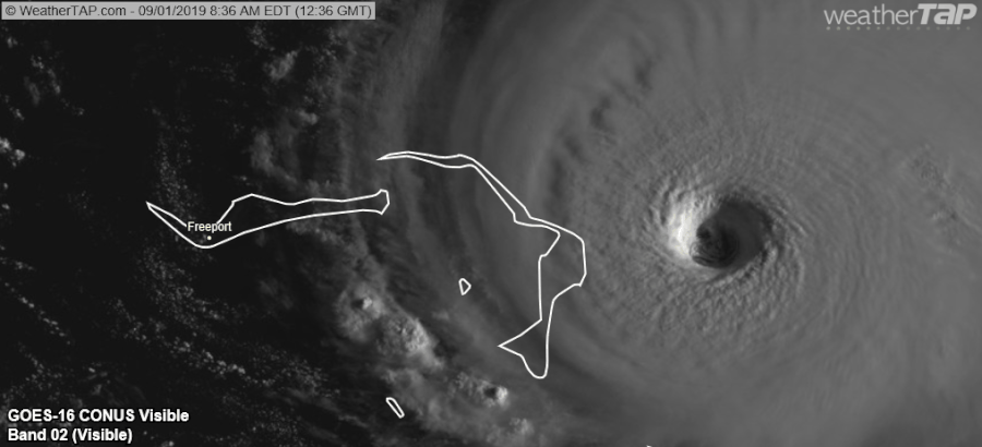
-
johngaltfla
- Category 5
- Posts: 2073
- Joined: Sun Jul 10, 2005 9:17 pm
- Location: Sarasota County, FL
- Contact:
Re: ATL: DORIAN - Hurricane - Discussion
CronkPSU wrote:HurricaneBelle wrote:CronkPSU wrote:
north and west....Polk County and Gulf Coast
not like they can hop in a car and drive there
geez my bad...I thought you meant Florida's east coast...sorry!!!
That's okay, if I were on the east coast I would NOT head to Polk County or the Gulf Coast. There is no definitive idea where this storm will go or turn over the Peninsula if it makes landfall. Tallahassee and NW Florida might be a good bet, Dothan, AL, etc. better.
3 likes
-
nativefloridian

- Tropical Storm
- Posts: 172
- Joined: Tue Aug 21, 2012 2:48 pm
- Location: Pembroke Pines, FL
Re: ATL: DORIAN - Hurricane - Discussion
boca wrote:Canelaw99 wrote:EquusStorm wrote:To be fair nearly half the Florida peninsula is still in the cone as it is, if people ignore everything but the center-line track that's kind of on them
Here in Dade, we’ve been out since yesterday. Everyone has stopped preparations. No lines for gas or at Publix yesterday. Everyone enjoying their weekend because it’s all clear. Local news even saying if your shutters aren’t up, don’t worry. We, as storm enthusiasts, know to not pay attention to the cone directly and always watch the storm until it passes us. Most lay people don’t. They go by what they’re being told, and right now they’re told we’re in the clear. There isn’t even a TS watch for Miami Dade at the moment. Schools aren’t closed Tuesday.
That might change after the 11am update
IMO it should change. Better to err on the side of caution before it's too late.
3 likes
Re: ATL: DORIAN - Hurricane - Discussion
tigerz3030 wrote:My concern from recent history is these things tend to go more west when this strong. Irma was due to hit east coast FL and wound up on west coast of FL. Michael last year was supposed to track more east over south central Ga and wound up over SW GA. Differences of ~90-100 miles. If Dorian does this then the peninsula of FL is in danger!
This ^^ I feel like almost every time after we have a Cat 5 Storm there ends up being this same discussion but when it comes to doing the forecasting it's disregarded for the models.
4 likes
// Opinions are my own, I am not a Meteorologist. Consult the NHC or Local NWS and Emergency Management for current information in your area. //
-
mrbagyo

- Category 5
- Posts: 3963
- Age: 33
- Joined: Thu Apr 12, 2012 9:18 am
- Location: 14.13N 120.98E
- Contact:
Re: ATL: DORIAN - Hurricane - Discussion
I checked the ADT 9.0 just to entertain myself.
Meh. The VMax output is just horrendous. ADT's algorithm needs an overhaul.
Meh. The VMax output is just horrendous. ADT's algorithm needs an overhaul.
0 likes
The posts in this forum are NOT official forecast and should not be used as such. They are just the opinion of the poster and may or may not be backed by sound meteorological data. They are NOT endorsed by any professional institution or storm2k.org. For official information, please refer to RSMC, NHC and NWS products.
-
Aric Dunn
- Category 5
- Posts: 21238
- Age: 43
- Joined: Sun Sep 19, 2004 9:58 pm
- Location: Ready for the Chase.
- Contact:
Re: ATL: DORIAN - Hurricane - Discussion
Pretty much the exact same postion of the ridging over the eastern US and the stalled trough over illinois.. everything is hold position except dorian that it..

3 likes
Note: If I make a post that is brief. Please refer back to previous posts for the analysis or reasoning. I do not re-write/qoute what my initial post said each time.
If there is nothing before... then just ask
Space & Atmospheric Physicist, Embry-Riddle Aeronautical University,
I believe the sky is falling...
If there is nothing before... then just ask
Space & Atmospheric Physicist, Embry-Riddle Aeronautical University,
I believe the sky is falling...
-
AtlanticWind
- S2K Supporter
- Posts: 1898
- Age: 67
- Joined: Sun Aug 08, 2004 9:57 pm
- Location: Plantation,Fla
Re: ATL: DORIAN - Hurricane - Discussion
KC7NEC wrote:tigerz3030 wrote:My concern from recent history is these things tend to go more west when this strong. Irma was due to hit east coast FL and wound up on west coast of FL. Michael last year was supposed to track more east over south central Ga and wound up over SW GA. Differences of ~90-100 miles. If Dorian does this then the peninsula of FL is in danger!
This ^^ I feel like almost every time after we have a Cat 5 Storm there ends up being this same discussion but when it comes to doing the forecasting it's disregarded for the models.
I have always noticed the NHC forecast for powerful storms to be better than weaker storms
Hope that continues
1 likes
-
JaxBeachFL
- Tropical Wave

- Posts: 4
- Joined: Tue Aug 29, 2017 8:27 pm
Re: ATL: DORIAN - Hurricane - Discussion
Just took a tour of Jax Beach & Neptune Beach (Jacksonville’s barrier island) in the golf cart. During Matthew & Irma I’d estimate we had a 60-70% boardup rate. Today I saw less than 5 residences boarded up & only a handful of businesses. Furthermore I didn’t see anyone dragging shutters out or stowing away lawn furniture. There is little to no prep occurring in this area.
The eastern shifts yesterday caused most beaches residents to not take this storm seriously. Just a normal Sunday here with people heading off to church, yoga, and breakfast.
The eastern shifts yesterday caused most beaches residents to not take this storm seriously. Just a normal Sunday here with people heading off to church, yoga, and breakfast.
Last edited by JaxBeachFL on Sun Sep 01, 2019 9:29 am, edited 2 times in total.
1 likes
-
CrazyC83
- Professional-Met

- Posts: 34315
- Joined: Tue Mar 07, 2006 11:57 pm
- Location: Deep South, for the first time!
Re: ATL: DORIAN - Hurricane - Discussion
I didn't expect to wake up to a monster like this. The worst part is land is in the way.
12 likes
-
eastcoastFL

- Category 5
- Posts: 3996
- Age: 44
- Joined: Thu Apr 12, 2007 12:29 pm
- Location: Palm City, FL
Re: ATL: DORIAN - Hurricane - Discussion
ThetaE wrote:Dorian has developed noticeably more banding this morning, on both satellite and radar imagery. It's an indication that the environment is incredibly favorable (hence the strengthening), but it also means that Dorian's stretch of no ERCs may be ending in the next 12-24 hours....
If Dorian goes through and ERC it may weaken it but on the downside it would expand its wind fields and size bringing more of Florida under TS or hurricane force winds...

2 likes
Personal Forecast Disclaimer:
The posts in this forum are NOT official forecast and should not be used as such. They are just the opinion of the poster and may or may not be backed by sound meteorological data. They are NOT endorsed by any professional institution or storm2k.org. For official information, please refer to the NHC and NWS products.
The posts in this forum are NOT official forecast and should not be used as such. They are just the opinion of the poster and may or may not be backed by sound meteorological data. They are NOT endorsed by any professional institution or storm2k.org. For official information, please refer to the NHC and NWS products.
-
tolakram
- Admin

- Posts: 20186
- Age: 62
- Joined: Sun Aug 27, 2006 8:23 pm
- Location: Florence, KY (name is Mark)
Re: ATL: DORIAN - Hurricane - Discussion
Miami long range

4 likes
M a r k
- - - - -
Join us in chat: Storm2K Chatroom Invite. Android and IOS apps also available.
The posts in this forum are NOT official forecasts and should not be used as such. Posts are NOT endorsed by any professional institution or STORM2K.org. For official information and forecasts, please refer to NHC and NWS products.
Who is online
Users browsing this forum: No registered users and 4 guests