 https://imgur.com/IC8wFog
@54hrs spread

https://imgur.com/25xsEzT
Moderator: S2k Moderators
https://imgur.com/IC8wFog


NDG wrote:Close up look of Euro's 0z ensembles, about a 1/3 of them bring Dorian either inland or much close to the coast than its operation run. Yet another trend to the west.
So today will be very important to see how far west Dorian moves near Grand Bahama, the more western it ends up the higher the chances it gets to the east coast of FL. IMO.
https://i.imgur.com/0HH3Cbk.gif
ronjon wrote:HWRF, CMC, and GFS all weaken the storm as it slides N-NW along Florida's east coast. The storm also greatly expands in size due to the weakening which allows a push toward the east coast from the Cape northward. This is what Levi Cowan discussed last night on his blog - as the storm weakens, it will be steered more by lower to mid levels rather than mid to high levels from a very deep storm. All this is bad news for folks in Florida near the coast as high winds, storm surge, and heavy rainfall will encompass a larger area.

KWT wrote:ronjon wrote:HWRF, CMC, and GFS all weaken the storm as it slides N-NW along Florida's east coast. The storm also greatly expands in size due to the weakening which allows a push toward the east coast from the Cape northward. This is what Levi Cowan discussed last night on his blog - as the storm weakens, it will be steered more by lower to mid levels rather than mid to high levels from a very deep storm. All this is bad news for folks in Florida near the coast as high winds, storm surge, and heavy rainfall will encompass a larger area.
Yes, the GFs in particular spreads hurricane force winds pretty much the whole up the east coast through to NC, which obviously could cause a large amount of damage, even if the system isn't the cat-5 monster it is still.
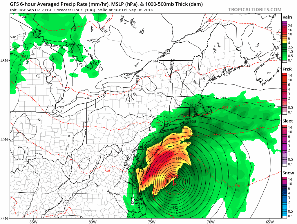

b0tzy29 wrote:The 06Z GFS is simply terrifying. That is really the only word that comes to mind when i look at it. I know we are still a bit of a ways out but this is getting way to close for comfort in the Long Island / Jersey Coast Area. I live on South Shore Long Island on the water and lived through Sandy. This is giving me flashbacks...
https://media.giphy.com/media/ZazoHHfBWOuBvf9dLh/source.gif
hohnywx wrote:b0tzy29 wrote:The 06Z GFS is simply terrifying. That is really the only word that comes to mind when i look at it. I know we are still a bit of a ways out but this is getting way to close for comfort in the Long Island / Jersey Coast Area. I live on South Shore Long Island on the water and lived through Sandy. This is giving me flashbacks...
https://media.giphy.com/media/ZazoHHfBWOuBvf9dLh/source.gif
Even if it were to come up to our area (the GFS is the only model really showing this), it would be no Sandy.


Users browsing this forum: No registered users and 114 guests


