


EPAC: ALVIN - Remnants
Moderator: S2k Moderators
-
TheAustinMan

- Category 4

- Posts: 997
- Age: 24
- Joined: Mon Jul 08, 2013 4:26 pm
- Location: United States
- Contact:
Re: EPAC: ALVIN - Tropical Storm
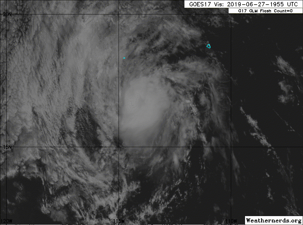
The eye has become increasingly apparent on visible imagery, and the storm's structure has been sneakily transitioning from the sheared character noted in the 21z advisory to a more round appearance. The eye is still not really there on the infrared bands but that could change in the relatively short window of intensification that the warm waters and divergent flow aloft offer within the next 12 hours. Hurricane intensity is possible, but good luck getting ASCAT to provide a convincing windfield given how small Alvin is. 
574 kB. Source: Composited using data from the College of DuPage

574 kB. Source: Composited using data from the College of DuPage
6 likes


Treat my opinions with a grain of salt. For official information see your local weather service.
-
Kingarabian

- S2K Supporter

- Posts: 15437
- Joined: Sat Aug 08, 2009 3:06 am
- Location: Honolulu, Hawaii
Re: EPAC: ALVIN - Tropical Storm
Just a bit more cooling of the CDO or the eye warming further, would likely net a 4.0 on Dvorak.
0 likes
RIP Kobe Bryant
-
Kingarabian
- S2K Supporter
- Posts: 15437
- Joined: Sat Aug 08, 2009 3:06 am
- Location: Honolulu, Hawaii
Re: EPAC: ALVIN - Tropical Storm
TheAustinMan wrote:The eye has become increasingly apparent on visible imagery, and the storm's structure has been sneakily transitioning from the sheared character noted in the 21z advisory to a more round appearance. The eye is still not really there on the infrared bands but that could change in the relatively short window of intensification that the warm waters and divergent flow aloft offer within the next 12 hours. Hurricane intensity is possible, but good luck getting ASCAT to provide a convincing windfield given how small Alvin is.
574 kB. Source: Composited using data from the College of DuPage
[url]https://i.imgur.com/uenzeHk.png[url]
Yeah the NHC has to abandon ASCAT for this to be declared a hurricane. ADT numbers are @ 3.7 which would mean 60kts and 989mb pressure. Just a little more work to do...
1 likes
RIP Kobe Bryant
-
cycloneye

- Admin

- Posts: 139104
- Age: 67
- Joined: Thu Oct 10, 2002 10:54 am
- Location: San Juan, Puerto Rico
Re: EPAC: ALVIN - Tropical Storm
Even is they dont go up to cane,HWRF was with the right idea on intensity.
1 likes
Visit the Caribbean-Central America Weather Thread where you can find at first post web cams,radars
and observations from Caribbean basin members Click Here
and observations from Caribbean basin members Click Here
-
Kingarabian
- S2K Supporter
- Posts: 15437
- Joined: Sat Aug 08, 2009 3:06 am
- Location: Honolulu, Hawaii
Re: EPAC: ALVIN - Tropical Storm
cycloneye wrote:Even is they dont go up to cane,HWRF was with the right idea on intensity.
Yup very good jobs by the HWRF and HMON. Their ability to have higher resolution on these type of systems make a huge difference. Completely beat the global and statistical models.
Anyways, AMSR2 pass finally came in and shows Alvin continuing to have a hurricane-esque eyewall/core.

ADT raw and adjusted numbers up to 4.0.
0 likes
RIP Kobe Bryant
-
Kingarabian
- S2K Supporter
- Posts: 15437
- Joined: Sat Aug 08, 2009 3:06 am
- Location: Honolulu, Hawaii
Re: EPAC: ALVIN - Tropical Storm
ADT CI numbers up to 4.4.
UW - CIMSS
ADVANCED DVORAK TECHNIQUE
ADT-Version 9.0
Tropical Cyclone Intensity Algorithm
----- Current Analysis -----
Date : 27 JUN 2019 Time : 225033 UTC
Lat : 16:49:43 N Lon : 114:33:32 W
CI# /Pressure/ Vmax
4.4 / 978.6mb/ 74.6kt
Final T# Adj T# Raw T#
4.4 4.4 4.0
Center Temp : -72.5C Cloud Region Temp : -65.4C
Scene Type : UNIFORM CDO CLOUD REGION w/ MW EYE
0 likes
RIP Kobe Bryant
-
Kingarabian
- S2K Supporter
- Posts: 15437
- Joined: Sat Aug 08, 2009 3:06 am
- Location: Honolulu, Hawaii
Re: EPAC: ALVIN - Tropical Storm
https://twitter.com/pppapin/status/1144364274011086853
It's hard to deny that it's a hurricane at this point. Portions of the eyewall on microwave imagery are strong enough and have been strong enough for the last 6 hours which indicates that wind speed near the center have reached hurricane strength.
It's hard to deny that it's a hurricane at this point. Portions of the eyewall on microwave imagery are strong enough and have been strong enough for the last 6 hours which indicates that wind speed near the center have reached hurricane strength.
1 likes
RIP Kobe Bryant
Re: EPAC: ALVIN - Tropical Storm
The eyewall isn't perfect obviously, but it does look stable enough and has persisted for long enough that I think Alvin may wind down a little slower than expected. He might be a fighter.
1 likes
Solar Aquarian
Lunar Cancerian
 Sagittarian
Lunar Cancerian
-
Sciencerocks
- Category 5

- Posts: 7286
- Age: 38
- Joined: Thu Jul 06, 2017 1:51 am
-
Kingarabian
- S2K Supporter
- Posts: 15437
- Joined: Sat Aug 08, 2009 3:06 am
- Location: Honolulu, Hawaii
Re: EPAC: ALVIN - Tropical Storm
TXPZ29 KNES 272137
TCSENP
CCB
A. 01E (ALVIN)
B. 27/1800Z
C. 16.2N
D. 113.8W
E. THREE/GOES-W
F. T3.5/3.5/D0.5/24HRS
G. IR/EIR/VIS/SSMIS
H. REMARKS...CORRECTED FOR INTENSITY BASED ON EYE IN 1916Z GMI DATA
AND VISIBLE IMAGERY. THE SUBSEQUENT APPEARANCE OF A CLOUD-FILLED EYE IN
VISIBLE IMAGERY WARRANTS FURTHER REANALYSIS. 1.25 DEGREE WELL-DEFINED
CDO RESULTS IN A DT OF 3.0. MET IS 4.0 WHILE PT IS 3.5. FT IS BASED ON
PT DUE TO ASYMMETRY IN THE CDO.
I. ADDL POSITIONS
27/1412Z 15.9N 113.1W SSMIS
...TURK
SAB came in with 3.5.
0 likes
RIP Kobe Bryant
-
Kingarabian
- S2K Supporter
- Posts: 15437
- Joined: Sat Aug 08, 2009 3:06 am
- Location: Honolulu, Hawaii
-
Kingarabian
- S2K Supporter
- Posts: 15437
- Joined: Sat Aug 08, 2009 3:06 am
- Location: Honolulu, Hawaii
Re: EPAC: ALVIN - Tropical Storm
SAB redid their fix, and it is indeed 4.0 on Dvorak.
28/0000 UTC 17.0N 114.8W T4.0/4.0 ALVIN -- East Pacific
28/0000 UTC 17.0N 114.8W T4.0/4.0 ALVIN -- East Pacific
0 likes
RIP Kobe Bryant
-
cycloneye
- Admin
- Posts: 139104
- Age: 67
- Joined: Thu Oct 10, 2002 10:54 am
- Location: San Juan, Puerto Rico
Re: EPAC: ALVIN - Tropical Storm
00z Best Track up to Hurricane.
Location: 17.0°N 114.8°W
Maximum Winds: 65 kt Gusts: N/A
Minimum Central Pressure: 992 mb
Environmental Pressure: 1008 mb
Radius of Circulation: 150 NM
Radius of Maximum Wind: 10 NM
Maximum Winds: 65 kt Gusts: N/A
Minimum Central Pressure: 992 mb
Environmental Pressure: 1008 mb
Radius of Circulation: 150 NM
Radius of Maximum Wind: 10 NM
0 likes
Visit the Caribbean-Central America Weather Thread where you can find at first post web cams,radars
and observations from Caribbean basin members Click Here
and observations from Caribbean basin members Click Here
-
Kingarabian
- S2K Supporter
- Posts: 15437
- Joined: Sat Aug 08, 2009 3:06 am
- Location: Honolulu, Hawaii
Re: EPAC: ALVIN - Tropical Storm
Alvin's core is very compact that any overshooting top will cloud the eye. Looks like a pinhole eye on miniature system.

Likely has intense winds.
Likely has intense winds.
1 likes
RIP Kobe Bryant
-
Astromanía
- Category 2

- Posts: 737
- Age: 25
- Joined: Sat Aug 25, 2018 10:34 pm
- Location: Monterrey, N.L, México
Re: EPAC: ALVIN - Tropical Storm
Congratulations Alvin! you are a fighter! you are not a pussy tropical storm you are an amazing hurricane, well a very tiny hurricane actually but still, I'm so proud of you!  , Clarion island under the gun tho
3 likes
-
Kingarabian
- S2K Supporter
- Posts: 15437
- Joined: Sat Aug 08, 2009 3:06 am
- Location: Honolulu, Hawaii
Re: EPAC: ALVIN - Tropical Storm
Astromanía wrote:Congratulations Alvin! you are a fighter! you are not a pussy tropical storm you are an amazing hurricane, well a very tiny hurricane actually but still, I'm so proud of you!
Shoutout to Chris90 for calling it first. I wasn't brave enough and unfortunately I underestimated the EPAC.
If yall look really closely he has a buzzsaw look. A mini buzzsaw!


3 likes
RIP Kobe Bryant
-
cycloneye
- Admin
- Posts: 139104
- Age: 67
- Joined: Thu Oct 10, 2002 10:54 am
- Location: San Juan, Puerto Rico
Re: EPAC: ALVIN - Hurricane
...ALVIN BECOMES THE FIRST HURRICANE OF THE 2019 EAST PACIFIC
SEASON...
SUMMARY OF 800 PM PDT...0300 UTC...INFORMATION
----------------------------------------------
LOCATION...17.4N 115.4W
ABOUT 520 MI...840 KM SW OF THE SOUTHERN TIP OF BAJA CALIFORNIA
MAXIMUM SUSTAINED WINDS...75 MPH...120 KM/H
PRESENT MOVEMENT...NW OR 305 DEGREES AT 16 MPH...26 KM/H
MINIMUM CENTRAL PRESSURE...992 MB...29.30 INCHES
Hurricane Alvin Discussion Number 10
NWS National Hurricane Center Miami FL EP012019
800 PM PDT Thu Jun 27 2019
Somewhat surprisingly, Alvin has strengthened into a hurricane this
evening. The diminutive system is exhibiting a rather symmetric
CDO with very deep convection bursting near the center. Microwave
images show a small eye about 10 n mi in diameter. Subjective
Dvorak classifications from both TAFB and SAB, along with objective
intensity estimates from UW-CIMSS, support a current intensity of
65 kt. Alvin is not expected to maintain its intensity for very
long. Within 12 to 24 hours, the cyclone should encounter
significantly stronger southwesterly shear and SSTs below 24 deg C.
These hostile environmental factors should bring about rapid
weakening, as supported by essentially all of the numerical
guidance. Alvin is expected to degenerate into a remnant low on
Saturday.
The hurricane is moving a little to the right and slightly faster
than previous estimates, with an initial motion of about 305/14 kt.
Alvin should continue to move near the western periphery of a
subtropical ridge for the next 48 hours, with the weakening cyclone
gradually turning toward the left and decelerating. The official
track forecast is very close to the latest corrected dynamical model
consensus.
FORECAST POSITIONS AND MAX WINDS
INIT 28/0300Z 17.4N 115.4W 65 KT 75 MPH
12H 28/1200Z 18.7N 117.1W 60 KT 70 MPH
24H 29/0000Z 20.1N 119.1W 45 KT 50 MPH
36H 29/1200Z 20.9N 120.6W 35 KT 40 MPH
48H 30/0000Z 21.5N 121.9W 25 KT 30 MPH...POST-TROP/REMNT LOW
72H 01/0000Z...DISSIPATED
$$
Forecaster Pasch
1 likes
Visit the Caribbean-Central America Weather Thread where you can find at first post web cams,radars
and observations from Caribbean basin members Click Here
and observations from Caribbean basin members Click Here
-
Kingarabian
- S2K Supporter
- Posts: 15437
- Joined: Sat Aug 08, 2009 3:06 am
- Location: Honolulu, Hawaii
Re: EPAC: ALVIN - Hurricane
Well if it still has another 12 more hours, based on its Dvorak presentation it theoretically could make a run @ MH status:

3 likes
RIP Kobe Bryant
-
cycloneye
- Admin
- Posts: 139104
- Age: 67
- Joined: Thu Oct 10, 2002 10:54 am
- Location: San Juan, Puerto Rico
Re: EPAC: ALVIN - Tropical Storm
Tropical Storm Alvin Discussion Number 11
NWS National Hurricane Center Miami FL EP012019
200 AM PDT Fri Jun 28 2019
Alvin's satellite presentation has begun to degrade overnight with
the overall cloud pattern becoming elongated from southwest to
northeast. Earlier ASCAT data indicated that the center was located
within the southwestern portion of the main convective mass,
suggesting that southwesterly shear has caused the system to become
less symmetric. Subjective Dvorak T-numbers from SAB and TAFB have
started to decrease, and a blend of the various satellite intensity
estimates yields an initial wind speed of 60 kt for this advisory.
Increasing southwesterly shear and cooler waters ahead of the storm
are expected to cause rapid weakening during the next 24 to 36
hours. Since Alvin is a small cyclone, it is likely to suffer
from the affects of the hostile environment more quickly. As a
result, the NHC intensity forecast calls for a faster rate of
weakening than indicated by the statistical SHIPS/LGEM models and
is closest to the latest Florida State Superensemble. The cyclone
is forecast to degenerate into a remnant low on Saturday and it
should dissipate shortly thereafter.
The initial motion estimate is 305/13 kt. The track forecast
philosophy remains the same as the previous advisory. Alvin should
continue to move around the western periphery of a subtropical ridge
during the next couple of days, with the weakening cyclone turning
more westward and decelerating. The latest NHC track forecast is
near the various consensus aids and is essentially an update of
the previous official forecast.
FORECAST POSITIONS AND MAX WINDS
INIT 28/0900Z 18.0N 116.3W 60 KT 70 MPH
12H 28/1800Z 19.2N 118.0W 55 KT 65 MPH
24H 29/0600Z 20.3N 119.8W 40 KT 45 MPH
36H 29/1800Z 20.9N 121.1W 25 KT 30 MPH...POST-TROP/REMNT LOW
48H 30/0600Z 21.3N 122.5W 20 KT 25 MPH...POST-TROP/REMNT LOW
72H 01/0600Z...DISSIPATED
$$
Forecaster Brown
0 likes
Visit the Caribbean-Central America Weather Thread where you can find at first post web cams,radars
and observations from Caribbean basin members Click Here
and observations from Caribbean basin members Click Here
Who is online
Users browsing this forum: No registered users and 25 guests