* EAST PACIFIC 2019 SHIPS INTENSITY FORECAST *
* IR SAT DATA AVAILABLE, OHC AVAILABLE *
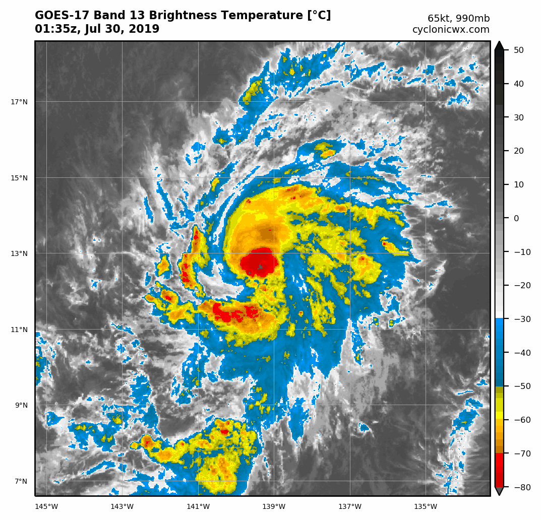
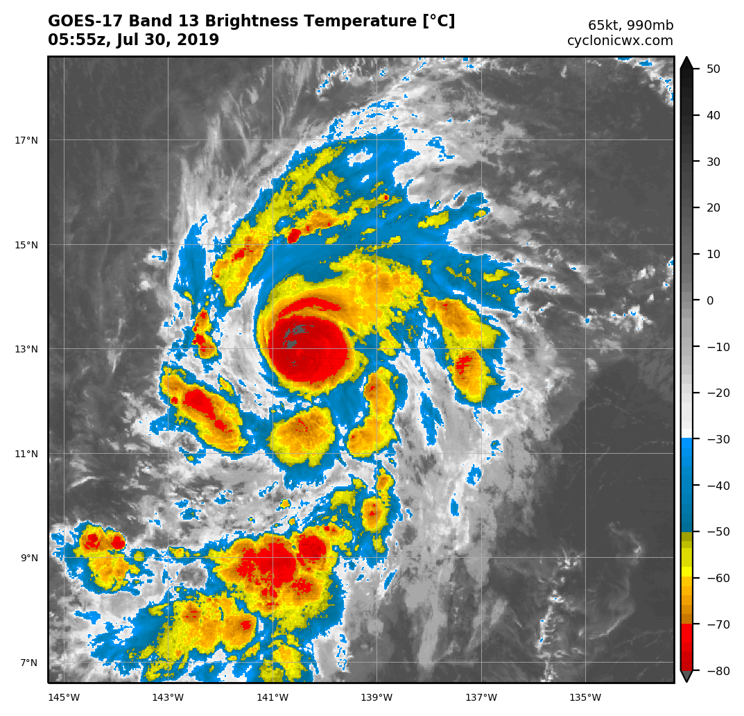
* ERICK EP062019 07/30/19 00 UTC *
TIME (HR) 0 6 12 18 24 36 48 60 72 84 96 108 120
V (KT) NO LAND 65 67 68 69 69 67 61 54 45 38 31 30 29
V (KT) LAND 65 67 68 69 69 67 61 54 45 38 31 30 29
V (KT) LGEM 65 67 68 68 68 65 60 53 46 38 33 29 27
Storm Type TROP TROP TROP TROP TROP TROP TROP TROP TROP TROP TROP TROP TROP
SHEAR (KT) 6 8 11 15 14 14 12 20 27 32 31 27 22
SHEAR ADJ (KT) -3 -2 -4 -6 -5 0 11 4 1 -1 -3 -2 -1
SHEAR DIR 256 271 290 290 300 299 270 264 266 266 263 267 270
SST (C) 27.8 28.1 28.1 27.9 27.7 27.5 27.2 27.4 28.1 27.5 27.5 27.5 27.7
POT. INT. (KT) 144 147 146 144 142 139 136 138 146 140 140 138 139
200 MB T (C) -52.6 -52.6 -52.6 -52.7 -52.4 -52.9 -52.6 -52.7 -52.9 -53.0 -53.1 -53.1 -53.3
200 MB VXT (C) 0.1 0.1 0.1 0.2 0.3 0.3 0.1 0.1 0.1 0.0 0.1 0.2 0.3
TH_E DEV (C) 7 6 6 6 6 6 7 7 7 8 8 8 7
700-500 MB RH 61 62 63 59 58 56 53 55 54 53 53 57 59
MODEL VTX (KT) 20 20 21 22 21 20 19 17 14 13 9 10 8
850 MB ENV VOR 10 20 29 24 21 1 -3 -7 -6 -8 0 8 16
200 MB DIV 43 27 28 43 51 18 14 7 9 13 45 40 35
700-850 TADV -2 -6 -6 -6 -3 0 7 2 4 4 4 1 3
LAND (KM) 1824 1676 1530 1390 1251 1030 806 644 492 331 349 461 516
LAT (DEG N) 12.6 12.9 13.1 13.5 13.9 14.7 15.3 15.6 15.7 16.0 16.4 16.9 17.4
LONG(DEG W) 139.3 140.7 142.1 143.3 144.6 146.5 148.6 150.3 152.4 154.9 157.6 159.6 160.9
STM SPEED (KT) 15 14 13 13 11 10 10 9 11 13 11 8 6
HEAT CONTENT 14 16 16 12 10 10 6 9 16 12 27 19 21
FORECAST TRACK FROM OFCI INITIAL HEADING/SPEED (DEG/KT):280/ 17 CX,CY: -16/ 3
T-12 MAX WIND: 60 PRESSURE OF STEERING LEVEL (MB): 576 (MEAN=587)
GOES IR BRIGHTNESS TEMP. STD DEV. 50-200 KM RAD: 14.3 (MEAN=14.5)
% GOES IR PIXELS WITH T < -20 C 50-200 KM RAD: 86.0 (MEAN=65.0)
PRELIM RI PROB (DV .GE. 35 KT IN 36 HR): 12.2
INDIVIDUAL CONTRIBUTIONS TO INTENSITY CHANGE
6 12 18 24 36 48 60 72 84 96 108 120
----------------------------------------------------------
SAMPLE MEAN CHANGE 0. 0. 1. 1. 1. 2. 1. 1. 1. 0. -1. -1.
SST POTENTIAL 1. 2. 3. 3. 3. 2. 1. 1. 0. -1. -1. -1.
VERTICAL SHEAR MAG 0. 0. -1. -1. -2. -2. -2. -3. -6. -8. -10. -12.
VERTICAL SHEAR ADJ 0. 1. 1. 2. 2. 1. 0. 0. 0. 0. 0. 0.
VERTICAL SHEAR DIR -1. -2. -3. -4. -6. -8. -10. -12. -12. -13. -13. -12.
PERSISTENCE 1. 1. 1. 1. 1. 1. 0. 0. 0. 0. 0. 0.
200/250 MB TEMP. 0. 0. 0. 0. 0. 0. -1. -1. -1. -1. -2. -2.
THETA_E EXCESS 0. 0. 0. 0. 0. 0. 0. 0. 1. 1. 1. 1.
700-500 MB RH 0. 0. 0. 0. 0. 0. 0. -1. -1. -1. -1. -1.
MODEL VTX TENDENCY 0. 1. 1. 1. 0. -1. -4. -8. -10. -15. -13. -14.
850 MB ENV VORTICITY 0. 0. 0. 0. 0. 0. 0. 0. 1. 1. 1. 1.
200 MB DIVERGENCE 0. 0. 0. 0. 0. 0. -1. -1. -2. -2. -1. -1.
850-700 T ADVEC 0. 0. 0. 0. 0. 0. 0. 0. 0. 0. 0. 0.
ZONAL STORM MOTION 0. 1. 1. 2. 2. 3. 4. 3. 3. 2. 2. 2.
STEERING LEVEL PRES 0. 0. 0. 0. 0. 0. 0. 0. 0. 0. 0. 0.
DAYS FROM CLIM. PEAK 0. 0. 0. 0. 0. 0. 0. 0. 0. 0. 0. 0.
GOES PREDICTORS 0. 0. 0. 0. 0. 1. 1. 1. 1. 1. 1. 1.
OCEAN HEAT CONTENT 0. 0. 0. 0. 0. 0. -1. 0. 0. 0. 0. 0.
RI POTENTIAL 0. 0. 0. 0. 0. 0. 0. 0. 0. 1. 1. 2.
----------------------------------------------------------
TOTAL CHANGE 2. 3. 5. 4. 2. -4. -11. -20. -27. -34. -35. -36.
CURRENT MAX WIND (KT): 65. LAT, LON: 12.6 139.3
** 2019 E. Pacific RI INDEX EP062019 ERICK 07/30/19 00 UTC **
(SHIPS-RII PREDICTOR TABLE for 30 KT OR MORE MAXIMUM WIND INCREASE IN NEXT 24-h)
Predictor Value RI Predictor Range Scaled Value(0-1) % Contribution
POT = MPI-VMAX (KT) : 79.7 40.5 to 149.3 0.36 2.4
12 HR PERSISTENCE (KT) : 5.0 -22.0 to 44.0 0.41 4.0
850-200 MB SHEAR (KT) : 10.9 19.6 to 1.6 0.48 3.9
D200 (10**7s-1) : 38.4 -33.0 to 156.2 0.38 2.5
MAXIMUM WIND (KT) : 65.0 22.5 to 132.0 0.90 5.8
HEAT CONTENT (KJ/CM2) : 13.6 2.7 to 106.7 0.10 0.5
STD DEV OF IR BR TEMP : 14.3 37.8 to 2.1 0.66 3.7
BL DRY-AIR FLUX (W/M2) : 282.6 800.8 to -82.5 0.59 0.0
2nd PC OF IR BR TEMP : 0.9 2.2 to -1.9 0.33 0.2
%area of TPW <45 mm upshear : 7.4 62.3 to 0.0 0.88 -0.2
SHIPS Prob RI for 20kt/ 12hr RI threshold= 17% is 2.9 times climatological mean ( 6.1%)
SHIPS Prob RI for 25kt/ 24hr RI threshold= 23% is 1.8 times climatological mean (12.5%)
SHIPS Prob RI for 30kt/ 24hr RI threshold= 23% is 2.7 times climatological mean ( 8.4%)
SHIPS Prob RI for 35kt/ 24hr RI threshold= 18% is 3.0 times climatological mean ( 6.0%)
SHIPS Prob RI for 40kt/ 24hr RI threshold= 11% is 2.9 times climatological mean ( 4.0%)
SHIPS Prob RI for 45kt/ 36hr RI threshold= 16% is 2.5 times climatological mean ( 6.5%)
SHIPS Prob RI for 55kt/ 48hr RI threshold= 12% is 2.0 times climatological mean ( 5.9%)
SHIPS Prob RI for 65kt/ 72hr RI threshold= 0% is 0.0 times climatological mean ( 4.8%)
Matrix of RI probabilities
------------------------------------------------------------------------------
RI (kt / h) | 20/12 | 25/24 | 30/24 | 35/24 | 40/24 | 45/36 | 55/48 |65/72
------------------------------------------------------------------------------
SHIPS-RII: 17.4% 23.1% 22.8% 17.7% 11.5% 16.1% 11.5% 0.0%
Logistic: 8.7% 17.7% 6.7% 5.0% 5.4% 1.4% 0.7% 0.2%
Bayesian: 1.7% 5.9% 1.0% 0.4% 0.5% 0.1% 0.0% 0.0%
Consensus: 9.3% 15.6% 10.2% 7.7% 5.8% 5.9% 4.1% 0.1%
DTOPS: 7.0% 23.0% 12.0% 9.0% 9.0% 6.0% 1.0% 0.0%
## ANNULAR HURRICANE INDEX (AHI) EP062019 ERICK 07/30/19 00 UTC ##
## STORM NOT ANNULAR, SCREENING STEP FAILED, NPASS=4 NFAIL=3 ##
## AHI= 0 (AHI OF 100 IS BEST FIT TO ANN. STRUC., 1 IS MARGINAL, 0 IS NOT ANNULAR) ##
* IR SAT DATA AVAILABLE, OHC AVAILABLE *
* ERICK EP062019 07/30/19 00 UTC *
TIME (HR) 0 6 12 18 24 36 48 60 72 84 96 108 120
V (KT) NO LAND 65 67 68 69 69 67 61 54 45 38 31 30 29
V (KT) LAND 65 67 68 69 69 67 61 54 45 38 31 30 29
V (KT) LGEM 65 67 68 68 68 65 60 53 46 38 33 29 27
Storm Type TROP TROP TROP TROP TROP TROP TROP TROP TROP TROP TROP TROP TROP
SHEAR (KT) 6 8 11 15 14 14 12 20 27 32 31 27 22
SHEAR ADJ (KT) -3 -2 -4 -6 -5 0 11 4 1 -1 -3 -2 -1
SHEAR DIR 256 271 290 290 300 299 270 264 266 266 263 267 270
SST (C) 27.8 28.1 28.1 27.9 27.7 27.5 27.2 27.4 28.1 27.5 27.5 27.5 27.7
POT. INT. (KT) 144 147 146 144 142 139 136 138 146 140 140 138 139
200 MB T (C) -52.6 -52.6 -52.6 -52.7 -52.4 -52.9 -52.6 -52.7 -52.9 -53.0 -53.1 -53.1 -53.3
200 MB VXT (C) 0.1 0.1 0.1 0.2 0.3 0.3 0.1 0.1 0.1 0.0 0.1 0.2 0.3
TH_E DEV (C) 7 6 6 6 6 6 7 7 7 8 8 8 7
700-500 MB RH 61 62 63 59 58 56 53 55 54 53 53 57 59
MODEL VTX (KT) 20 20 21 22 21 20 19 17 14 13 9 10 8
850 MB ENV VOR 10 20 29 24 21 1 -3 -7 -6 -8 0 8 16
200 MB DIV 43 27 28 43 51 18 14 7 9 13 45 40 35
700-850 TADV -2 -6 -6 -6 -3 0 7 2 4 4 4 1 3
LAND (KM) 1824 1676 1530 1390 1251 1030 806 644 492 331 349 461 516
LAT (DEG N) 12.6 12.9 13.1 13.5 13.9 14.7 15.3 15.6 15.7 16.0 16.4 16.9 17.4
LONG(DEG W) 139.3 140.7 142.1 143.3 144.6 146.5 148.6 150.3 152.4 154.9 157.6 159.6 160.9
STM SPEED (KT) 15 14 13 13 11 10 10 9 11 13 11 8 6
HEAT CONTENT 14 16 16 12 10 10 6 9 16 12 27 19 21
FORECAST TRACK FROM OFCI INITIAL HEADING/SPEED (DEG/KT):280/ 17 CX,CY: -16/ 3
T-12 MAX WIND: 60 PRESSURE OF STEERING LEVEL (MB): 576 (MEAN=587)
GOES IR BRIGHTNESS TEMP. STD DEV. 50-200 KM RAD: 14.3 (MEAN=14.5)
% GOES IR PIXELS WITH T < -20 C 50-200 KM RAD: 86.0 (MEAN=65.0)
PRELIM RI PROB (DV .GE. 35 KT IN 36 HR): 12.2
INDIVIDUAL CONTRIBUTIONS TO INTENSITY CHANGE
6 12 18 24 36 48 60 72 84 96 108 120
----------------------------------------------------------
SAMPLE MEAN CHANGE 0. 0. 1. 1. 1. 2. 1. 1. 1. 0. -1. -1.
SST POTENTIAL 1. 2. 3. 3. 3. 2. 1. 1. 0. -1. -1. -1.
VERTICAL SHEAR MAG 0. 0. -1. -1. -2. -2. -2. -3. -6. -8. -10. -12.
VERTICAL SHEAR ADJ 0. 1. 1. 2. 2. 1. 0. 0. 0. 0. 0. 0.
VERTICAL SHEAR DIR -1. -2. -3. -4. -6. -8. -10. -12. -12. -13. -13. -12.
PERSISTENCE 1. 1. 1. 1. 1. 1. 0. 0. 0. 0. 0. 0.
200/250 MB TEMP. 0. 0. 0. 0. 0. 0. -1. -1. -1. -1. -2. -2.
THETA_E EXCESS 0. 0. 0. 0. 0. 0. 0. 0. 1. 1. 1. 1.
700-500 MB RH 0. 0. 0. 0. 0. 0. 0. -1. -1. -1. -1. -1.
MODEL VTX TENDENCY 0. 1. 1. 1. 0. -1. -4. -8. -10. -15. -13. -14.
850 MB ENV VORTICITY 0. 0. 0. 0. 0. 0. 0. 0. 1. 1. 1. 1.
200 MB DIVERGENCE 0. 0. 0. 0. 0. 0. -1. -1. -2. -2. -1. -1.
850-700 T ADVEC 0. 0. 0. 0. 0. 0. 0. 0. 0. 0. 0. 0.
ZONAL STORM MOTION 0. 1. 1. 2. 2. 3. 4. 3. 3. 2. 2. 2.
STEERING LEVEL PRES 0. 0. 0. 0. 0. 0. 0. 0. 0. 0. 0. 0.
DAYS FROM CLIM. PEAK 0. 0. 0. 0. 0. 0. 0. 0. 0. 0. 0. 0.
GOES PREDICTORS 0. 0. 0. 0. 0. 1. 1. 1. 1. 1. 1. 1.
OCEAN HEAT CONTENT 0. 0. 0. 0. 0. 0. -1. 0. 0. 0. 0. 0.
RI POTENTIAL 0. 0. 0. 0. 0. 0. 0. 0. 0. 1. 1. 2.
----------------------------------------------------------
TOTAL CHANGE 2. 3. 5. 4. 2. -4. -11. -20. -27. -34. -35. -36.
CURRENT MAX WIND (KT): 65. LAT, LON: 12.6 139.3
** 2019 E. Pacific RI INDEX EP062019 ERICK 07/30/19 00 UTC **
(SHIPS-RII PREDICTOR TABLE for 30 KT OR MORE MAXIMUM WIND INCREASE IN NEXT 24-h)
Predictor Value RI Predictor Range Scaled Value(0-1) % Contribution
POT = MPI-VMAX (KT) : 79.7 40.5 to 149.3 0.36 2.4
12 HR PERSISTENCE (KT) : 5.0 -22.0 to 44.0 0.41 4.0
850-200 MB SHEAR (KT) : 10.9 19.6 to 1.6 0.48 3.9
D200 (10**7s-1) : 38.4 -33.0 to 156.2 0.38 2.5
MAXIMUM WIND (KT) : 65.0 22.5 to 132.0 0.90 5.8
HEAT CONTENT (KJ/CM2) : 13.6 2.7 to 106.7 0.10 0.5
STD DEV OF IR BR TEMP : 14.3 37.8 to 2.1 0.66 3.7
BL DRY-AIR FLUX (W/M2) : 282.6 800.8 to -82.5 0.59 0.0
2nd PC OF IR BR TEMP : 0.9 2.2 to -1.9 0.33 0.2
%area of TPW <45 mm upshear : 7.4 62.3 to 0.0 0.88 -0.2
SHIPS Prob RI for 20kt/ 12hr RI threshold= 17% is 2.9 times climatological mean ( 6.1%)
SHIPS Prob RI for 25kt/ 24hr RI threshold= 23% is 1.8 times climatological mean (12.5%)
SHIPS Prob RI for 30kt/ 24hr RI threshold= 23% is 2.7 times climatological mean ( 8.4%)
SHIPS Prob RI for 35kt/ 24hr RI threshold= 18% is 3.0 times climatological mean ( 6.0%)
SHIPS Prob RI for 40kt/ 24hr RI threshold= 11% is 2.9 times climatological mean ( 4.0%)
SHIPS Prob RI for 45kt/ 36hr RI threshold= 16% is 2.5 times climatological mean ( 6.5%)
SHIPS Prob RI for 55kt/ 48hr RI threshold= 12% is 2.0 times climatological mean ( 5.9%)
SHIPS Prob RI for 65kt/ 72hr RI threshold= 0% is 0.0 times climatological mean ( 4.8%)
Matrix of RI probabilities
------------------------------------------------------------------------------
RI (kt / h) | 20/12 | 25/24 | 30/24 | 35/24 | 40/24 | 45/36 | 55/48 |65/72
------------------------------------------------------------------------------
SHIPS-RII: 17.4% 23.1% 22.8% 17.7% 11.5% 16.1% 11.5% 0.0%
Logistic: 8.7% 17.7% 6.7% 5.0% 5.4% 1.4% 0.7% 0.2%
Bayesian: 1.7% 5.9% 1.0% 0.4% 0.5% 0.1% 0.0% 0.0%
Consensus: 9.3% 15.6% 10.2% 7.7% 5.8% 5.9% 4.1% 0.1%
DTOPS: 7.0% 23.0% 12.0% 9.0% 9.0% 6.0% 1.0% 0.0%
## ANNULAR HURRICANE INDEX (AHI) EP062019 ERICK 07/30/19 00 UTC ##
## STORM NOT ANNULAR, SCREENING STEP FAILED, NPASS=4 NFAIL=3 ##
## AHI= 0 (AHI OF 100 IS BEST FIT TO ANN. STRUC., 1 IS MARGINAL, 0 IS NOT ANNULAR) ##