ATL: ERIN - Tropical Depression - Discussion

Moderator: S2k Moderators

Message
Author
User avatar
wxman57
Moderator-Pro Met
Moderator-Pro Met
Posts: 22482
Age: 66
Joined: Sat Jun 21, 2003 8:06 pm
Location: Houston, TX (southwest)

Re: ATL: INVEST 98L - Discussion

#281 Postby wxman57 » Sat Aug 24, 2019 12:08 pm

MGC wrote:No development until low moves over water or center reforms offshore.....MGC


Or, quite possibly, "no development" would suffice. Certainly not today. Models have backed off on development.
1 likes   

User avatar
Hammy
Category 5
Category 5
Posts: 5594
Age: 40
Joined: Fri May 25, 2012 5:25 pm
Contact:

Re: ATL: INVEST 98L - Discussion

#282 Postby Hammy » Sat Aug 24, 2019 12:20 pm

Pending the Euro forecast, I'm leaning strongly towards no development with this--the background state over water simply isn't favorable this year.
1 likes   
The above post is not official and should not be used as such. It is the opinion of the poster and may or may not be backed by sound meteorological data. It is not endorsed by any professional institution or storm2k.org. For official information, please refer to the NHC and NWS products.

User avatar
DioBrando
Category 4
Category 4
Posts: 917
Age: 27
Joined: Sun Aug 12, 2018 12:45 pm

Re: ATL: INVEST 98L - Discussion

#283 Postby DioBrando » Sat Aug 24, 2019 12:21 pm

Hammy wrote:Pending the Euro forecast, I'm leaning strongly towards no development with this--the background state over water simply isn't favorable this year.


30 degrees Celcius.
High oceanic heat content.
Last edited by DioBrando on Sat Aug 24, 2019 12:23 pm, edited 1 time in total.
1 likes   
blonde stacey (xe/xem/xir)

jlauderdal
S2K Supporter
S2K Supporter
Posts: 6771
Joined: Wed May 19, 2004 5:46 am
Location: NE Fort Lauderdale
Contact:

Re: RE: Re: ATL: INVEST 98L - Discussion

#284 Postby jlauderdal » Sat Aug 24, 2019 12:23 pm

CW0262 wrote:Port St Lucie FL North Fork St Lucie River Observations :D

http://www.findu.com/cgi-bin/wxpage.cgi?call=CW0262
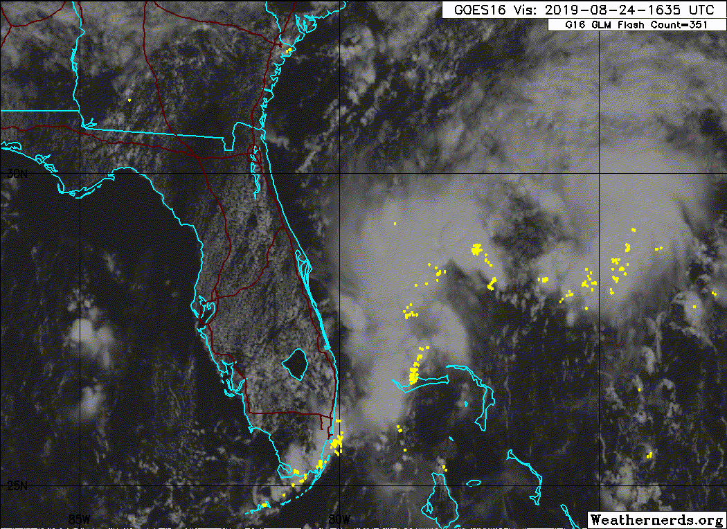
Dont let your guard down, convection on the increase in south florida

Sent from my SM-G973U using Tapatalk
1 likes   

User avatar
eastcoastFL
Category 5
Category 5
Posts: 3437
Age: 42
Joined: Thu Apr 12, 2007 12:29 pm
Location: Palm City, FL

Re: ATL: INVEST 98L - Discussion

#285 Postby eastcoastFL » Sat Aug 24, 2019 12:30 pm

Im in West Palm right now and the storms passing through at the moment are intense. Very heavy rain and lightening.
0 likes   
Personal Forecast Disclaimer:
The posts in this forum are NOT official forecast and should not be used as such. They are just the opinion of the poster and may or may not be backed by sound meteorological data. They are NOT endorsed by any professional institution or storm2k.org. For official information, please refer to the NHC and NWS products.

User avatar
Hammy
Category 5
Category 5
Posts: 5594
Age: 40
Joined: Fri May 25, 2012 5:25 pm
Contact:

Re: ATL: INVEST 98L - Discussion

#286 Postby Hammy » Sat Aug 24, 2019 12:33 pm

DioBrando wrote:
Hammy wrote:Pending the Euro forecast, I'm leaning strongly towards no development with this--the background state over water simply isn't favorable this year.


30 degrees Celcius.
High oceanic heat content.


But high shear and drier air nearby, as well as looking like it might get elongated by the approaching trough.
0 likes   
The above post is not official and should not be used as such. It is the opinion of the poster and may or may not be backed by sound meteorological data. It is not endorsed by any professional institution or storm2k.org. For official information, please refer to the NHC and NWS products.

User avatar
DioBrando
Category 4
Category 4
Posts: 917
Age: 27
Joined: Sun Aug 12, 2018 12:45 pm

Re: ATL: INVEST 98L - Discussion

#287 Postby DioBrando » Sat Aug 24, 2019 12:59 pm

Hammy wrote:
DioBrando wrote:
Hammy wrote:Pending the Euro forecast, I'm leaning strongly towards no development with this--the background state over water simply isn't favorable this year.


30 degrees Celcius.
High oceanic heat content.


But high shear and drier air nearby, as well as looking like it might get elongated by the approaching trough.


Which will both peter out. ;)
Things are ever-constantly changing!
1 likes   
blonde stacey (xe/xem/xir)

User avatar
Ubuntwo
Category 5
Category 5
Posts: 1089
Age: 30
Joined: Thu Oct 05, 2017 10:41 pm

Re: ATL: INVEST 98L - Discussion

#288 Postby Ubuntwo » Sat Aug 24, 2019 1:05 pm

Look at long-ranged Melbourne radar. Strongest vorticity by far is ~100 miles due east of the radar site. The beam's at 10kft so not sure how much of that is at the surface.
0 likes   
Kendall -> SLO -> PBC

Memorable Storms: Katrina (for its Florida landfall...) Wilma Matthew Irma

User avatar
CyclonicFury
Category 5
Category 5
Posts: 1975
Age: 25
Joined: Sun Jul 02, 2017 12:32 pm
Location: NC
Contact:

Re: ATL: INVEST 98L - Discussion

#289 Postby CyclonicFury » Sat Aug 24, 2019 1:08 pm

This will still likely develop but a hurricane is looking less likely.
4 likes   
NCSU B.S. in Meteorology Class of 2021. Tropical weather blogger at http://www.cyclonicfury.com. My forecasts and thoughts are NOT official, for official forecasts please consult the National Hurricane Center.

User avatar
artist
Category 5
Category 5
Posts: 9793
Joined: Mon Jun 06, 2005 3:26 pm
Location: West Palm

Re: ATL: INVEST 98L - Discussion

#290 Postby artist » Sat Aug 24, 2019 1:26 pm

The low near Naples appears to be dipping right into the edge of the gulf.

Image
2 likes   

User avatar
northjaxpro
S2K Supporter
S2K Supporter
Posts: 8900
Joined: Mon Sep 27, 2010 11:21 am
Location: Jacksonville, FL

Re: ATL: INVEST 98L - Discussion

#291 Postby northjaxpro » Sat Aug 24, 2019 3:04 pm

Melboune NWS Radar and Visible Satelitte Imagery shows that a potential new LLC may be taking shape about 100.miles east of Melbourne, FL.
2 likes   
NEVER, EVER SAY NEVER in the tropics and weather in general, and most importantly, with life itself!!

________________________________________________________________________________________

Fay 2008 Beryl 2012 Debby 2012 Colin 2016 Hermine 2016 Julia 2016 Matthew 2016 Irma 2017 Dorian 2019

sikkar
Category 1
Category 1
Posts: 323
Joined: Sun Aug 26, 2012 1:44 am
Location: Florida

Re: ATL: INVEST 98L - Discussion

#292 Postby sikkar » Sat Aug 24, 2019 3:07 pm

northjaxpro wrote:Melboune NWS Radar and Visible Satelitte Imagery shows that a potential new LLC may be taking shape about 100.miles east of Melbourne, FL.


It kinda looks like a depression to my untrained eyes.
0 likes   
Personal Forecast Disclaimer:
The posts in this forum are NOT official forecast and should not be used as such. They are just the opinion of the poster and may or may not be backed by sound meteorological data. For official information, please refer to the NHC and NWS products.

Sciencerocks
Category 5
Category 5
Posts: 7286
Age: 38
Joined: Thu Jul 06, 2017 1:51 am

Re: ATL: INVEST 98L - Discussion

#293 Postby Sciencerocks » Sat Aug 24, 2019 3:10 pm

Image
1 likes   

User avatar
wxman57
Moderator-Pro Met
Moderator-Pro Met
Posts: 22482
Age: 66
Joined: Sat Jun 21, 2003 8:06 pm
Location: Houston, TX (southwest)

Re: ATL: INVEST 98L - Discussion

#294 Postby wxman57 » Sat Aug 24, 2019 3:12 pm

The weak low near Naples can be ignored. I think a new center will form closer to the convection tomorrow. Could become a TD/TS tomorrow night.
8 likes   

User avatar
Ivanhater
Storm2k Moderator
Storm2k Moderator
Posts: 10852
Age: 37
Joined: Fri Jul 01, 2005 8:25 am
Location: Pensacola

Re: ATL: INVEST 98L - Discussion

#295 Postby Ivanhater » Sat Aug 24, 2019 3:36 pm

A lot of posts here sway every model run. The same posters that said cat 5 Michael would be a sheared October storm.

Tropics are heating up and I don't think August will go without a named storm like some have forecasted
7 likes   
Michael

User avatar
DioBrando
Category 4
Category 4
Posts: 917
Age: 27
Joined: Sun Aug 12, 2018 12:45 pm

Re: ATL: INVEST 98L - Discussion

#296 Postby DioBrando » Sat Aug 24, 2019 3:37 pm

Ivanhater wrote:A lot of posts here sway every model run. The same posters that said cat 5 Michael would be a sheared October storm.

Tropics are heating up and I don't think August will go without a named storm like some have forecasted

chantal was here yesterday ;)
1 likes   
blonde stacey (xe/xem/xir)

User avatar
northjaxpro
S2K Supporter
S2K Supporter
Posts: 8900
Joined: Mon Sep 27, 2010 11:21 am
Location: Jacksonville, FL

Re: ATL: INVEST 98L - Discussion

#297 Postby northjaxpro » Sat Aug 24, 2019 3:50 pm

sikkar wrote:
northjaxpro wrote:Melboune NWS Radar and Visible Satelitte Imagery shows that a potential new LLC may be taking shape about 100.miles east of Melbourne, FL.


It kinda looks like a depression to my untrained eyes.


Yes. I think the new LLC is just on the edge of that convective complex just north of the NW Bahamas. I am confident we finally have our developing cyclone and it should go on and be designated in the nextt 12-24 hours if not sooner.Likely will be TS by end of tomorrow. (Sunday evening)
Last edited by northjaxpro on Sat Aug 24, 2019 3:52 pm, edited 1 time in total.
0 likes   
NEVER, EVER SAY NEVER in the tropics and weather in general, and most importantly, with life itself!!

________________________________________________________________________________________

Fay 2008 Beryl 2012 Debby 2012 Colin 2016 Hermine 2016 Julia 2016 Matthew 2016 Irma 2017 Dorian 2019

User avatar
crownweather
S2K Supporter
S2K Supporter
Posts: 576
Age: 49
Joined: Sat Aug 12, 2006 9:21 am
Location: Sturbridge, Massachusetts
Contact:

Re: ATL: INVEST 98L - Discussion

#298 Postby crownweather » Sat Aug 24, 2019 3:51 pm

DioBrando wrote:
Ivanhater wrote:A lot of posts here sway every model run. The same posters that said cat 5 Michael would be a sheared October storm.

Tropics are heating up and I don't think August will go without a named storm like some have forecasted

chantal was here yesterday ;)


And now we have Dorian. 2 Named Storms in August.
4 likes   
Rob Lightbown
Crown Weather Services
https://crownweather.com

User avatar
northjaxpro
S2K Supporter
S2K Supporter
Posts: 8900
Joined: Mon Sep 27, 2010 11:21 am
Location: Jacksonville, FL

Re: ATL: INVEST 98L - Discussion

#299 Postby northjaxpro » Sat Aug 24, 2019 4:27 pm

:::
Last edited by northjaxpro on Sat Aug 24, 2019 4:47 pm, edited 1 time in total.
0 likes   
NEVER, EVER SAY NEVER in the tropics and weather in general, and most importantly, with life itself!!

________________________________________________________________________________________

Fay 2008 Beryl 2012 Debby 2012 Colin 2016 Hermine 2016 Julia 2016 Matthew 2016 Irma 2017 Dorian 2019

User avatar
AnnularCane
S2K Supporter
S2K Supporter
Posts: 2635
Joined: Thu Jun 08, 2006 9:18 am
Location: Wytheville, VA

Re: ATL: INVEST 98L - Discussion

#300 Postby AnnularCane » Sat Aug 24, 2019 4:28 pm

crownweather wrote:
DioBrando wrote:
Ivanhater wrote:A lot of posts here sway every model run. The same posters that said cat 5 Michael would be a sheared October storm.

Tropics are heating up and I don't think August will go without a named storm like some have forecasted

chantal was here yesterday ;)


And now we have Dorian. 2 Named Storms in August.


And maybe Erin soon.
1 likes   


Return to “2019”

Who is online

Users browsing this forum: No registered users and 96 guests