ATL: DORIAN - Post-Tropical - Discussion
Moderator: S2k Moderators
-
galaxy401

- Category 5

- Posts: 2299
- Age: 29
- Joined: Sat Aug 25, 2012 9:04 pm
- Location: Casa Grande, Arizona
Re: ATL: INVEST 99L - Discussion
Yeah the NHC seems to be behind with this system. The first outlooks should have been issued a couple days ago. August 20th really is the date everything changes.
1 likes
Got my eyes on moving right into Hurricane Alley: Florida.
-
AutoPenalti
- Category 5
- Posts: 3949
- Age: 27
- Joined: Mon Aug 17, 2015 4:16 pm
- Location: Ft. Lauderdale, Florida
Re: ATL: INVEST 99L - Discussion
That is one very impressive structure. It still has a lot work to do. Needs to fight a ULL to its north west and dry air still a bit of an issue.
0 likes
The posts in this forum are NOT official forecasts and should not be used as such. They are just the opinion of the poster and may or may not be backed by sound meteorological data. They are NOT endorsed by any professional institution or STORM2K. For official information, please refer to products from the NHC and NWS.
Model Runs Cheat Sheet:
GFS (5:30 AM/PM, 11:30 AM/PM)
HWRF, GFDL, UKMET, NAVGEM (6:30-8:00 AM/PM, 12:30-2:00 AM/PM)
ECMWF (1:45 AM/PM)
TCVN is a weighted averaged

Re: ATL: INVEST 99L - Discussion
This is already at least a TD, I’ve seen worst looking elongated circulations being upgraded in the EPAC this year. The trusted Euro let the NHC down, like I mentioned earlier it has not being doing well recognizing low latitude waves this year in Atlantic.
5 likes
-
Kazmit

- Category 5
- Posts: 1915
- Age: 21
- Joined: Mon Jul 25, 2016 8:49 am
- Location: Williamsburg VA for college, Bermuda otherwise
Re: ATL: INVEST 99L - Discussion
It's going to need to gain quite a bit of latitude if it wants to make it north of the Greater Antilles. It seems like that's the track that will keep conditions the most favorable. The other possibilities are it gets shredded by Hispaniola or by shear in the eastern Caribbean.
0 likes
Igor 2010, Sandy 2012, Fay 2014, Gonzalo 2014, Joaquin 2015, Nicole 2016, Humberto 2019
I am only a tropical weather enthusiast. My predictions are not official and may or may not be backed by sound meteorological data. For official information, please refer to the NHC and NWS products.
I am only a tropical weather enthusiast. My predictions are not official and may or may not be backed by sound meteorological data. For official information, please refer to the NHC and NWS products.
-
AutoPenalti
- Category 5
- Posts: 3949
- Age: 27
- Joined: Mon Aug 17, 2015 4:16 pm
- Location: Ft. Lauderdale, Florida
Re: ATL: INVEST 99L - Discussion
A special advisory might be issued pretty soon. NHC are in no rush to raise chances or classify systems if there’s no immediate threat to land.
0 likes
The posts in this forum are NOT official forecasts and should not be used as such. They are just the opinion of the poster and may or may not be backed by sound meteorological data. They are NOT endorsed by any professional institution or STORM2K. For official information, please refer to products from the NHC and NWS.
Model Runs Cheat Sheet:
GFS (5:30 AM/PM, 11:30 AM/PM)
HWRF, GFDL, UKMET, NAVGEM (6:30-8:00 AM/PM, 12:30-2:00 AM/PM)
ECMWF (1:45 AM/PM)
TCVN is a weighted averaged
-
TheStormExpert

- Category 5
- Posts: 8487
- Age: 30
- Joined: Wed Feb 16, 2011 5:38 pm
- Location: Palm Beach Gardens, FL
Re: ATL: INVEST 99L - Discussion
Tropical Tidbits Levi Cowan starting to hand it to the GFS for sniffing this out.
https://twitter.com/tropicaltidbits/status/1164942356191354880
https://twitter.com/tropicaltidbits/status/1164942356191354880
1 likes
The following post is NOT an official forecast and should not be used as such. It is just the opinion of the poster and may or may not be backed by sound meteorological data. It is NOT endorsed by storm2k.org.
-
gatorcane

- S2K Supporter

- Posts: 23499
- Age: 46
- Joined: Sun Mar 13, 2005 3:54 pm
- Location: Boca Raton, FL
Re: ATL: INVEST 99L - Discussion
Yeah kudos to the GFS that is for sure. Euro completely missed it along with every other model. My guess is because of its small size so the other models missed it.
2 likes

Re: ATL: INVEST 99L - Discussion

7 likes
Very useful information on the Dvorak Technique --
https://severe.worldweather.wmo.int/TCF ... kBeven.pdf
https://severe.worldweather.wmo.int/TCF ... kBeven.pdf
-
tropicwatch

- Category 5
- Posts: 3205
- Age: 60
- Joined: Sat Jun 02, 2007 10:01 am
- Location: Panama City Florida
- Contact:
Re: ATL: INVEST 99L - Discussion
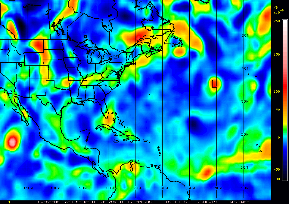
Significant increase in 850mb vorticity with 99L.
2 likes
Tropicwatch
Agnes 72', Eloise 75, Elena 85', Kate 85', Charley 86', Florence 88', Beryl 94', Dean 95', Erin 95', Opal 95', Earl 98', Georges 98', Ivan 2004', Arlene 2005', Dennis 2005', Ida 2009' Debby 2012' Irma 2017' Michael 2018'
Agnes 72', Eloise 75, Elena 85', Kate 85', Charley 86', Florence 88', Beryl 94', Dean 95', Erin 95', Opal 95', Earl 98', Georges 98', Ivan 2004', Arlene 2005', Dennis 2005', Ida 2009' Debby 2012' Irma 2017' Michael 2018'
-
northjaxpro

- S2K Supporter
- Posts: 8900
- Joined: Mon Sep 27, 2010 11:21 am
- Location: Jacksonville, FL
Re: ATL: INVEST 99L - Discussion
2 likes
NEVER, EVER SAY NEVER in the tropics and weather in general, and most importantly, with life itself!!
________________________________________________________________________________________
Fay 2008 Beryl 2012 Debby 2012 Colin 2016 Hermine 2016 Julia 2016 Matthew 2016 Irma 2017 Dorian 2019
________________________________________________________________________________________
Fay 2008 Beryl 2012 Debby 2012 Colin 2016 Hermine 2016 Julia 2016 Matthew 2016 Irma 2017 Dorian 2019

Re: ATL: INVEST 99L - Discussion
galaxy401 wrote:Yeah the NHC seems to be behind with this system. The first outlooks should have been issued a couple days ago. August 20th really is the date everything changes.
They didn't trust the GFS with the others not developing, and for good reason as the model has a terrible history with phantom storms, even in the short range. It's a sort of crying wolf situation.
0 likes
The above post is not official and should not be used as such. It is the opinion of the poster and may or may not be backed by sound meteorological data. It is not endorsed by any professional institution or storm2k.org. For official information, please refer to the NHC and NWS products.
-
gatorcane
- S2K Supporter
- Posts: 23499
- Age: 46
- Joined: Sun Mar 13, 2005 3:54 pm
- Location: Boca Raton, FL
Re: ATL: INVEST 99L - Discussion
Looks to be gaining some latitude at the end of the loop:
https://www.tropicaltidbits.com/sat/sat ... roduct=vis
https://www.tropicaltidbits.com/sat/sat ... roduct=vis
1 likes
-
cycloneye

- Admin

- Posts: 139295
- Age: 67
- Joined: Thu Oct 10, 2002 10:54 am
- Location: San Juan, Puerto Rico
Re: ATL: INVEST 99L - Discussion
Recent satellite wind data indicate that a low pressure area has
formed in association with a tropical wave located about 1300
miles east-southeast of the Windward Islands. Additional
development of this system is possible during the next few days, and
a tropical depression could form late this weekend or early next
week as it moves generally westward to west-northwestward near 15
mph.
* Formation chance through 48 hours...medium...40 percent.
* Formation chance through 5 days...medium...50 percent.
0 likes
Visit the Caribbean-Central America Weather Thread where you can find at first post web cams,radars
and observations from Caribbean basin members Click Here
and observations from Caribbean basin members Click Here


Re: ATL: INVEST 99L - Discussion
Convection has pulsed down for the moment, which is fairly typical as we reach DMIN out there. I would guess this gets classified at 5AM given the lack of strong convection right now and the fact it was only designated as an invest this morning, although it may already meet the criteria of a TC. Nice banding structure visible right now.

1 likes
Re: ATL: INVEST 99L - Discussion

0 likes
Very useful information on the Dvorak Technique --
https://severe.worldweather.wmo.int/TCF ... kBeven.pdf
https://severe.worldweather.wmo.int/TCF ... kBeven.pdf

Re: ATL: INVEST 99L - Discussion
Called it.
I seriously wonder if this (likely Erin) would be our first major of the year.
I seriously wonder if this (likely Erin) would be our first major of the year.
1 likes
blonde stacey (xe/xem/xir)

Re: ATL: INVEST 99L - Discussion
northjaxpro wrote:NOW, this one has my attention right off the bat. As Aric stated I think we FINALLY may have our first true and real and genuine MDR system that will actually have an opportunity to fully mature into a potential formidable tropical cyclone .
Dry air should not be a crippling inhibitor with.99L this time around. Origin of this system tied to the ITCZ initially.
On a side note, I also am impressed with the tropical wave behind 99L just off the African coast. That will be the.next invest soon. The North Atlantic basin looks to have finally.awakened folks, ,after a long summer slumber. Just in time for the approach of the peak time of the season
Mark Sudduth has basically been warning about the probability of the proverbial "lid" coming off in his last several YouTube videos. He may not be a meteorologist, but he seems to know what he's talking about.
9 likes
Re: ATL: INVEST 99L - Discussion
northjaxpro wrote::uarrow: Yes indeed. GFS long range forecasting past 7 days has been so much.improved, not just only with the tropics, but with winter-time synoptics as well.
The GFS has definitely improved this year when compared to former years. The other day it was right on the money in showing Barbados and the Windward Islands would get rain, over a week in advance. Someone's been doing some tweaking!
4 likes
-
HurricaneAndre2008

- Category 1

- Posts: 250
- Age: 26
- Joined: Wed Jul 31, 2019 9:51 pm
- Contact:
Re: ATL: INVEST 99L - Discussion
Global Tropics Hazards and Benefits Outlook Discussion
Last Updated: 08.23.19 Valid: 08.21.19 - 09.03.19
The original outlook remains largely on track, with dynamical model forecasts converging around the earlier GEFS/CFS perspective regarding a Kelvin wave tracking rapidly across the Indian Ocean to the Maritime Continent over the next 10-15 days. There is some projection of this feature onto the RMM Index, although the phase speed of the eastward propagating intraseasonal envelope is near the boundary of characteristic MJO and Kelvin wave events (period of approximately 20-25 days).
NHC is currently monitoring a disturbance over the Bahamas, giving it a 70% (90%) chance of becoming a TC over the next 48 hours (5 days) off the Southeast coast, resulting in a high risk for TC formation being introduced here. NHC is also monitoring a tropical wave near 10N/43W, with 40% (50%) chances of development over the next 48 hours (5 days), which corresponds to moderate confidence of TC formation in this outlook. In the East Pacific, Tropical Storm Ivo formed on the 21st, verifying the high risk from the original outlook that is subsequently dropped from this update. The moderate risk of TC formation area from the original outlook may have missed its chance to develop, as the Central Pacific Hurricane Center now gives it a near 0 (30%) chance of forming over the next 48 hrs (5 days), resulting in it being left off the update. Tropical Storm Bailu formed over the West Pacific on the 21st and is forecast to track across Taiwan over the weekend. JTWC is monitoring another system (99W) near 7N/145E that has a low chance of developing in the next 24 hours, but dynamical model guidance is more supportive of development over the weekend or early next week, resulting in a moderate confidence of TC formation area being included east of the Philippines.
As anticipated, wind shear over the Atlantic main development region (MDR) has relaxed in the wake of the Kelvin wave passage. Broad subsidence continues to be forecast over the MDR consistent with the low-frequency state. Model guidance is more bullish than Tuesday on possible TC formation in the vicinity of Cape Verde during Week-2, resulting in moderate confidence of cyclogenesis for a region roughly between 10-20N and 50W and the African coastline. The west-southwest to east-northeast orientation of the TC formation focus suggests a relatively southern track for the system around the base of the subtropical high, supporting a potential track toward the Lesser Antilles during the first third of September. U.S. interests should also pay close attention to subsequent updates of this outlook for more information as the system possibly comes closer to becoming a reality. The Week-2 West Pacific TC formation area is maintained, while any activity southeast of Hawaii appears less likely resulting in that area being downgraded from the graphic.
Above- and below-normal precipitation regions from Tuesday are updated to reflect the latest guidance regarding TC tracks in addition to dynamical model precipitation forecasts.
0 likes
Cindy(2005), Katrina(2005), Rita(2005), Erin(2007), Isaac(2012)
Re: ATL: INVEST 99L - Discussion
gatorcane wrote:Looks to be gaining some latitude at the end of the loop:
https://www.tropicaltidbits.com/sat/sat ... roduct=vis
I thought the same thing. Could be a wobble or a genuine change in direction. IDK
0 likes
Who is online
Users browsing this forum: No registered users and 25 guests