ATL: FIFTEEN - Remnants - Discussion
Moderator: S2k Moderators
-
northjaxpro

- S2K Supporter

- Posts: 8900
- Joined: Mon Sep 27, 2010 11:21 am
- Location: Jacksonville, FL
Re: ATL: INVEST 94L - Discussion
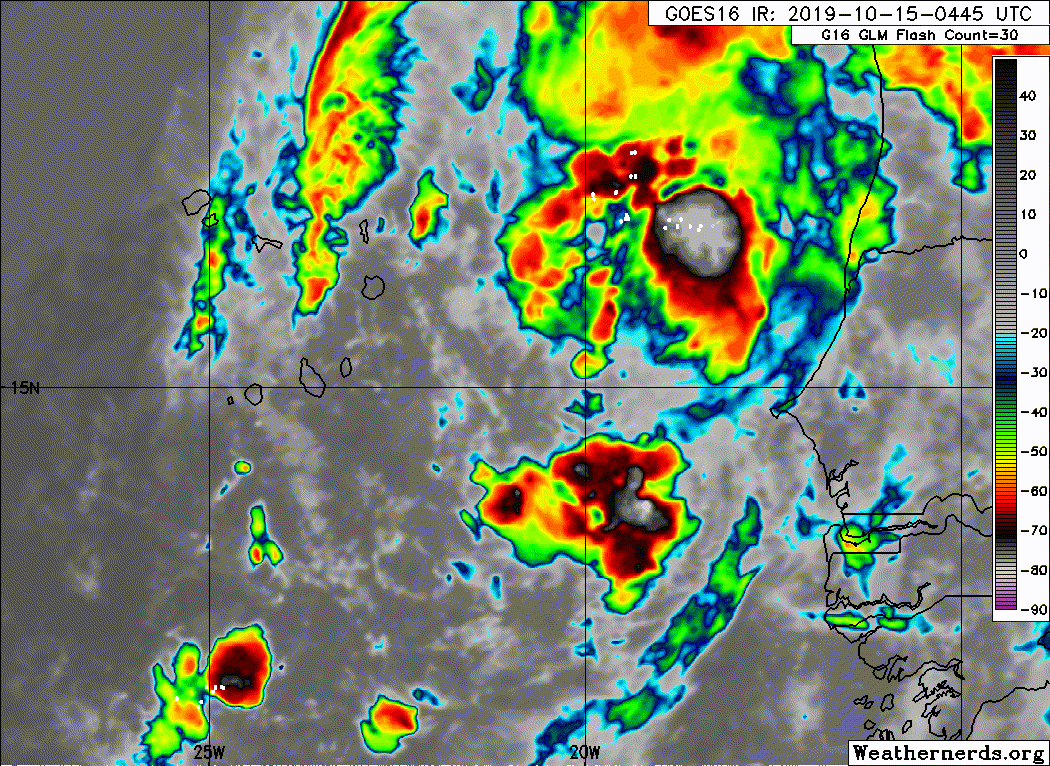
Whenever the next convective burst occurs near the coc in a little while, NHC will upgrade TD 15 to Nestor. It should happen soon, within the next 12 -18 hours. Impressive late season CV storm! Satellite presentaton with this is very impressive!
2 likes
NEVER, EVER SAY NEVER in the tropics and weather in general, and most importantly, with life itself!!
________________________________________________________________________________________
Fay 2008 Beryl 2012 Debby 2012 Colin 2016 Hermine 2016 Julia 2016 Matthew 2016 Irma 2017 Dorian 2019
________________________________________________________________________________________
Fay 2008 Beryl 2012 Debby 2012 Colin 2016 Hermine 2016 Julia 2016 Matthew 2016 Irma 2017 Dorian 2019
-
TallyTracker
- Category 2

- Posts: 584
- Joined: Thu Oct 11, 2018 2:46 pm
Re: ATL: INVEST 94L - Discussion
Convection is still pulsing near the center, but this does look like a TD. The banding is becoming apparent on IR imagery. I expect it will be TS Nestor by tomorrow morning come D-MAX.
0 likes
Fran '96, Georges '98, Gordon '00, Gabrielle '01, Charley '04, Frances '04, Jeanne '04, Barry '07, Fay '08, Debby '12, Matthew '16, Emily '17, Irma '17, Michael ‘18, Elsa ‘21, Fred ‘21, Mindy ‘21, Nicole ‘22, Idalia ‘23


Re: ATL: INVEST 94L - Discussion
troppy tidbits puts this as td15
ouch!
ouch!
0 likes
blonde stacey (xe/xem/xir)
-
cycloneye

- Admin

- Posts: 139086
- Age: 67
- Joined: Thu Oct 10, 2002 10:54 am
- Location: San Juan, Puerto Rico
Re: ATL: FITHTEEN - Tropical Depression - Discussion
BULLETIN
Tropical Depression Fifteen Advisory Number 1
NWS National Hurricane Center Miami FL AL152019
500 PM AST Mon Oct 14 2019
...NEW TROPICAL DEPRESSION FORMS SOUTHEAST OF THE CABO VERDE
ISLANDS...
...HEAVY RAINS EXPECTED ACROSS EASTERN CABO VERDE ISLANDS TONIGHT...
SUMMARY OF 500 PM AST...2100 UTC...INFORMATION
----------------------------------------------
LOCATION...13.2N 20.2W
ABOUT 320 MI...515 KM SE OF THE CABO VERDE ISLANDS
MAXIMUM SUSTAINED WINDS...35 MPH...55 KM/H
PRESENT MOVEMENT...NW OR 310 DEGREES AT 8 MPH...13 KM/H
MINIMUM CENTRAL PRESSURE...1006 MB...29.71 INCHES
WATCHES AND WARNINGS
--------------------
There are no coastal watches or warnings in effect.
However, interests in the Cabo Verde Islands should closely monitor
the progress of the depression since a Tropical Storm Warning may be
required for portions of the islands later tonight or early Tuesday.
DISCUSSION AND OUTLOOK
----------------------
At 500 PM AST (2100 UTC), the center of newly formed Tropical
Depression Fifteen was located near latitude 13.2 North, longitude
20.2 West. The depression is moving toward the northwest near 8 mph
(13 km/h), and this general motion is expected to continue through
Wednesday. On the forecast track, the center of the depression is
expected to pass over or near the eastern Cabo Verde Islands on
Tuesday, and pass near the central portion of those islands Tuesday
night and Wednesday morning.
Maximum sustained winds are near 35 mph (55 km/h) with higher gusts.
Slight strengthening is forecast during the next 48 hours, and the
depression is expected to become a tropical storm by early Tuesday
morning. Rapid weakening is forecast to begin by Wednesday morning
when the cyclone will be moving away from the Cabo Verde Islands.
The estimated minimum central pressure is 1006 mb (29.71 inches).
HAZARDS AFFECTING LAND
----------------------
RAINFALL: The depression is expected to produce rainfall
accumulations of 1 to 3 inches across the Cabo Verde Islands, with
isolated maximum amounts of 5 inches in the higher terrain,
especially across the eastern portion of the islands. This rainfall
may cause flash flooding and mudslides.
WIND: Tropical storm conditions could occur across the eastern
Capo Verde Islands by Tuesday morning, and then gradually spread
westward across the central portion of the islands by Tuesday
night, making outside preparations difficult or dangerous.
NEXT ADVISORY
-------------
Next complete advisory at 1100 PM AST.
$$
Forecaster Stewart
Tropical Depression Fifteen Discussion Number 1
NWS National Hurricane Center Miami FL AL152019
500 PM AST Mon Oct 14 2019
The large low pressure system that moved off the coast of Africa
yesterday has gradually become better defined based on earlier ASCAT
scatterometer wind data and recent visible satellite imagery.
Several fragmented curved bands have been developing during the past
several hours, especially in the northern semicircle, and the
aforementioned ASCAT passes indicated that winds of 30-32 kt were
present northwest of the center. The initial intensity is set at 30
kt based on a blend of the scatterometer wind data and a satellite
intensity estimate of T1.5/25 kt from SAB, and the rather broad
nature of the depression.
A surge of mid-level dry air has recently penetrated into the
inner-core region, causing some erosion of the central deep
convection. However, this is expected to be a temporary condition
with convection returning later tonight and early Tuesday during the
normal nocturnal convective maximum period. However, the large size
of the cyclone -- more than 1000 nmi wide -- should prevent any
rapid or significant intensification. With very low vertical shear
conditions forecast by the GFS and ECMWF models to continue for the
next 24 to 36 hours, at least some modest strengthening seems likely
given the unusually warm SSTs of near 28.5 deg C that the cyclone
will be traversing during that time. By 48 hours, the shear is
forecast to increase from the southwest in excess of 25 kt,
resulting in weakening into a remnant low shortly thereafter. By 72
hours and beyond, the shear is expected to increase to more than 40
kt, which will cause rapid weakening and dissipation by the 120-h
period, if not sooner. The official intensity forecast is similar to
a blend of the NOAA-HCCA and IVCN consensus models, and the GFS-
and ECMWF-based Decay-SHIPS statistical intensity models.
The initial motion estimate is northwestward or 310/07 kt. The
latest NHC model guidance is in very good agreement on the tropical
cyclone moving generally northwestward around the southwestern
periphery of a deep-layer ridge for the next 48 hours. Thereafter,
the models diverge significantly based on how soon the cyclone
weakens and turns westward within the low-level easterly trade wind
flow. The ECMWF holds on to a vertically deeper system a little
longer than the GFS, UKMET, HWRF, and HMON models, resulting in a
longer northwestward track. However, since the cyclone will likely
have become a vertically shallow remnant low by 72 hours, the NHC
official forecast track is a little to the left of ECMWF solution,
closer to the TVCN and HCCA consensus model tracks at 72 and 96 h.
FORECAST POSITIONS AND MAX WINDS
INIT 14/2100Z 13.2N 20.2W 30 KT 35 MPH
12H 15/0600Z 14.3N 21.1W 35 KT 40 MPH
24H 15/1800Z 15.5N 22.4W 40 KT 45 MPH
36H 16/0600Z 16.7N 23.4W 40 KT 45 MPH
48H 16/1800Z 18.1N 24.6W 35 KT 40 MPH
72H 17/1800Z 20.4N 26.9W 25 KT 30 MPH...POST-TROP/REMNT LOW
96H 18/1800Z 21.4N 29.0W 20 KT 25 MPH...POST-TROP/REMNT LOW
120H 19/1800Z...DISSIPATED
$$
Forecaster Stewart
1 likes
Visit the Caribbean-Central America Weather Thread where you can find at first post web cams,radars
and observations from Caribbean basin members Click Here
and observations from Caribbean basin members Click Here
-
CrazyC83
- Professional-Met

- Posts: 33393
- Joined: Tue Mar 07, 2006 11:57 pm
- Location: Deep South, for the first time!
Re: ATL: FIFTEEN - Tropical Depression - Discussion
I wonder if it is already a TS given the ASCAT pass readings and low resolution?
1 likes

Re: ATL: FIFTEEN - Tropical Depression - Discussion
We broke the 94L curse. This'll be the second farthest east in October and I believe the farthest east after October 10 if it can strengthen further.
0 likes
The above post is not official and should not be used as such. It is the opinion of the poster and may or may not be backed by sound meteorological data. It is not endorsed by any professional institution or storm2k.org. For official information, please refer to the NHC and NWS products.
Re: ATL: FIFTEEN - Tropical Depression - Discussion
Hammy wrote:We broke the 94L curse. This'll be the second farthest east in October and I believe the farthest east after October 10 if it can strengthen further.
what's the 94l curse
0 likes
blonde stacey (xe/xem/xir)
-
NotSparta

- Professional-Met
- Posts: 1648
- Age: 22
- Joined: Fri Aug 18, 2017 8:24 am
- Location: Naples, FL
- Contact:
Re: ATL: INVEST 94L - Discussion
DioBrando wrote:troppy tidbits puts this as td15
ouch!
That's ATCF
1 likes
This post was probably an opinion of mine, and in no way is official. Please refer to http://www.hurricanes.gov for official tropical analysis and advisories.
My website, with lots of tropical wx graphics, including satellite and recon: http://cyclonicwx.com
My website, with lots of tropical wx graphics, including satellite and recon: http://cyclonicwx.com
Re: ATL: INVEST 94L - Discussion
NotSparta wrote:DioBrando wrote:troppy tidbits puts this as td15
ouch!
That's ATCF
ik
1 likes
blonde stacey (xe/xem/xir)
-
MarioProtVI
- Category 2
- Posts: 670
- Age: 22
- Joined: Sun Sep 29, 2019 7:33 pm
- Location: New Jersey
Re: ATL: FIFTEEN - Tropical Depression - Discussion
Satellite presentation not as good as earlier, can see why 00z kept it as a TD. Kinda skeptical this even gets named considering NHC mentioned there is a surge of dry air near and being entrained into circulation. Size may also cause some issues.
0 likes
-
Monsoonjr99
- Tropical Storm

- Posts: 208
- Age: 24
- Joined: Fri Sep 21, 2018 11:22 pm
- Location: Inland Empire, SoCal
Re: ATL: FIFTEEN - Tropical Depression - Discussion
TD 15 seems dominated by the D-min/D-max cycle. If this is going to become Nestor, I don't think it will be before the next D-max.
0 likes
The posts in this forum are NOT official forecasts and should not be used as such. They are just the opinion of the poster and may or may not be backed by sound meteorological data. They are NOT endorsed by any professional institution or STORM2K. For official information, please refer to products from the NHC and NWS.
Some Californian who codes things and tracks weather.
Kay '22, Hilary '23
-
cycloneye
- Admin
- Posts: 139086
- Age: 67
- Joined: Thu Oct 10, 2002 10:54 am
- Location: San Juan, Puerto Rico
Re: ATL: FIFTEEN - Tropical Depression - Discussion
BULLETIN
Tropical Depression Fifteen Advisory Number 2
NWS National Hurricane Center Miami FL AL152019
1100 PM AST Mon Oct 14 2019
...POORLY ORGANIZED TROPICAL DEPRESSION EXPECTED TO BRING HEAVY
RAINS TO THE EASTERN CABO VERDE ISLANDS ON TUESDAY...
SUMMARY OF 1100 PM AST...0300 UTC...INFORMATION
-----------------------------------------------
LOCATION...14.5N 20.8W
ABOUT 235 MI...380 KM ESE OF THE CABO VERDE ISLANDS
MAXIMUM SUSTAINED WINDS...35 MPH...55 KM/H
PRESENT MOVEMENT...NW OR 320 DEGREES AT 10 MPH...17 KM/H
MINIMUM CENTRAL PRESSURE...1006 MB...29.71 INCHES
WATCHES AND WARNINGS
--------------------
There are no coastal watches or warnings in effect.
Interests in the Cabo Verde Islands should closely monitor the
progress of the depression since a Tropical Storm Warning could be
required for a portion of the islands on Tuesday.
DISCUSSION AND OUTLOOK
----------------------
At 1100 PM AST (0300 UTC), the center of Tropical Depression Fifteen
was located near latitude 14.5 North, longitude 20.8 West. The
depression is moving toward the northwest near 10 mph (17 km/h),
and this general motion is expected to continue through Wednesday.
On the forecast track, the center of the depression is expected to
pass over or near the eastern Cabo Verde Islands on Tuesday, and
then move near or north of the central Cabo Verde Islands Tuesday
night and Wednesday.
Maximum sustained winds are near 35 mph (55 km/h) with higher
gusts. Slight strengthening is possible during the next day or so,
and the depression is forecast to become a tropical storm on
Tuesday. Weakening is forecast to begin by Wednesday morning
when the cyclone will be moving away from the Cabo Verde Islands.
The estimated minimum central pressure is 1006 mb (29.71 inches).
HAZARDS AFFECTING LAND
----------------------
RAINFALL: The depression is expected to produce rainfall
accumulations of 1 to 3 inches across the Cabo Verde Islands, with
isolated maximum amounts of 5 inches in the higher terrain,
especially across the eastern portion of the islands. This rainfall
may cause flash flooding and mudslides.
WIND: Tropical storm conditions could occur across the eastern
Cabo Verde Islands on Tuesday.
NEXT ADVISORY
-------------
Next complete advisory at 500 AM AST.
$$
Forecaster Brown
Tropical Depression Fifteen Discussion Number 2
NWS National Hurricane Center Miami FL AL152019
1100 PM AST Mon Oct 14 2019
The depression has become somewhat less organized this evening. A
band of deep convection has developed over the far northern portion
of the circulation, but there is little convection over the
remainder of the large circulation. A recent partial ASCAT-C
overpass suggests that the low-level center is located well
southwest of the mid-level turning noted in infrared satellite
pictures, and although the scatterometer did not sample the entire
circulation, it appears that the 30-kt initial intensity may be
generous.
The depression is moving northwestward (320 degrees) at about
9 kt. While there is a chance that the center will re-form farther
north near the mid-level center and area of deep convection, the
overall motion of the system is expected to be northwestward
during the next day or two around the southwestward periphery
of a deep-layer ridge over western Africa. The models are in
generally good agreement on this overall scenario, but since the
system is still in the formative stage there is a fair amount of
cross-track spread. After 48 hours, the cyclone should turn toward
the left as it weakens and is steered by the low-level flow. The
new NHC track forecast has been adjusted north of the previous
track, but is not quite as far north as the ECMWF and the
multi-model consensus.
Deep convection is likely to return overnight during the typical
nocturnal convective maximum, and low shear and warm SSTs along the
path of the cyclone favor strengthening during the next day or so.
The large and sprawling structure of the system, however, suggest
any intensification should be slow to occur, and the new NHC
intensity forecast has been reduced slightly from the previous
advisory. By 36 hours, increasing southwesterly shear and cooler
SSTs are expected to cause the cyclone to weaken and the system is
forecast to degenerate into a remnant low in 2 to 3 days. The NHC
intensity forecast most closely follows the statistical SHIPS/LGEM
guidance.
Regardless of whether the depression becomes a tropical storm or not
before passing near the Cabo Verde Islands, the primary threat from
this system is the potential for locally heavy rainfall and flash
flooding in those islands.
FORECAST POSITIONS AND MAX WINDS
INIT 15/0300Z 14.5N 20.8W 30 KT 35 MPH
12H 15/1200Z 15.5N 21.7W 30 KT 35 MPH
24H 16/0000Z 16.8N 22.9W 35 KT 40 MPH
36H 16/1200Z 18.1N 23.9W 35 KT 40 MPH
48H 17/0000Z 19.3N 24.8W 30 KT 35 MPH
72H 18/0000Z 21.6N 27.5W 20 KT 25 MPH...POST-TROP/REMNT LOW
96H 19/0000Z...DISSIPATED
$$
Forecaster Brown
0 likes
Visit the Caribbean-Central America Weather Thread where you can find at first post web cams,radars
and observations from Caribbean basin members Click Here
and observations from Caribbean basin members Click Here
-
Sciencerocks
- Category 5

- Posts: 7286
- Age: 38
- Joined: Thu Jul 06, 2017 1:51 am
-
Sciencerocks
- Category 5
- Posts: 7286
- Age: 38
- Joined: Thu Jul 06, 2017 1:51 am
Re: ATL: FIFTEEN - Tropical Depression - Discussion
000
WTNT45 KNHC 150845
TCDAT5
Tropical Depression Fifteen Discussion Number 3
NWS National Hurricane Center Miami FL AL152019
500 AM AST Tue Oct 15 2019
The depression remains poorly organized this morning with only
loosely fragmented curved bands observed within the broad
circulation. The satellite intensity estimates suggest that the
cyclone has not strengthened, and the initial wind speed remains 30
kt, which is near the high end of the Dvorak estimates.
The center of the cyclone has been challenging to locate, and the
satellite center fixes from TAFB and SAB were about 60 n mi apart.
The initial motion is estimated to be northwestward, or 325 degrees,
at 10 kt, but this is of low confidence given the broad nature of
the system. The depression is expected to move generally
northwestward during the next couple of days steered by a
mid-level ridge over western Africa. A turn to the west-northwest
is forecast beyond a couple of days when the weak and shallow
system is expected to be steered by the low-level flow. The NHC
track forecast takes the center of the depression near the eastern
Cabo Verde Islands later today, and this forecast lies near the
various consensus models.
The environmental conditions are expected to remain generally
favorable for about the next 12-24 hours, so there is some chance
that the cyclone could become a tropical storm during that time.
However, given the large size of the system, significant
intensification is not expected. On Wednesday, a pronounced
increase in southwesterly wind shear, drier air, and cooler SSTs
should end the opportunity for strengthening and cause the cyclone
to become a remnant low in about 2 days when the shear is forecast
to be very strong. All of the models show the cyclone opening up
into a trough within 3 or 4 days.
Regardless of whether or not the depression becomes a tropical storm
before passing near the Cabo Verde Islands, the primary threat from
this system is the potential for locally heavy rainfall and flash
flooding in those islands.
FORECAST POSITIONS AND MAX WINDS
INIT 15/0900Z 15.6N 20.9W 30 KT 35 MPH
12H 15/1800Z 16.4N 22.0W 35 KT 40 MPH
24H 16/0600Z 17.5N 23.0W 35 KT 40 MPH
36H 16/1800Z 18.4N 24.1W 30 KT 35 MPH
48H 17/0600Z 19.4N 25.3W 25 KT 30 MPH...POST-TROP/REMNT LOW
72H 18/0600Z 21.5N 29.0W 20 KT 25 MPH...POST-TROP/REMNT LOW
96H 19/0600Z...DISSIPATED
$$
Forecaster Cangialosi
0 likes
-
MarioProtVI
- Category 2
- Posts: 670
- Age: 22
- Joined: Sun Sep 29, 2019 7:33 pm
- Location: New Jersey
Re: ATL: FIFTEEN - Tropical Depression - Discussion
Model guidance has really backed off on any sort of intensification due to the poor organization and it seems very likely this will not become Nestor - even the OFCL which is the NHC intensity has now gone below TS, likely indicative of the cone at 11 reflecting this. The 30 kt estimate seems too high as ASCAT caught only 20-25 kt max in the convection and also missed the center which already looks to be elongating. Nonetheless still impressive for such a cyclone to exist in this region this late in the season though.

0 likes
-
wxman57

- Moderator-Pro Met

- Posts: 22482
- Age: 66
- Joined: Sat Jun 21, 2003 8:06 pm
- Location: Houston, TX (southwest)
Re: ATL: FIFTEEN - Tropical Depression - Discussion
This one's already history. Looks like a tropical wave today. Next!

4 likes
-
HurricaneAndre2008

- Category 1

- Posts: 250
- Age: 26
- Joined: Wed Jul 31, 2019 9:51 pm
- Contact:
Re: ATL: FIFTEEN - Tropical Depression - Discussion
Looks to be Nestor now. ADT numbers suggest that now
Current Intensity Analysis
UW - CIMSS
ADVANCED DVORAK TECHNIQUE
ADT-Version 9.0
Tropical Cyclone Intensity Algorithm
----- Current Analysis -----
Date : 15 OCT 2019 Time : 161500 UTC
Lat : 15:43:26 N Lon : 21:43:10 W
CI# /Pressure/ Vmax
2.5 /1005.8mb/ 35.0kt
Final T# Adj T# Raw T#
2.5 2.7 2.7
Current Intensity Analysis
UW - CIMSS
ADVANCED DVORAK TECHNIQUE
ADT-Version 9.0
Tropical Cyclone Intensity Algorithm
----- Current Analysis -----
Date : 15 OCT 2019 Time : 161500 UTC
Lat : 15:43:26 N Lon : 21:43:10 W
CI# /Pressure/ Vmax
2.5 /1005.8mb/ 35.0kt
Final T# Adj T# Raw T#
2.5 2.7 2.7
0 likes
Cindy(2005), Katrina(2005), Rita(2005), Erin(2007), Isaac(2012)
-
northjaxpro
- S2K Supporter
- Posts: 8900
- Joined: Mon Sep 27, 2010 11:21 am
- Location: Jacksonville, FL
Re: ATL: FIFTEEN - Tropical Depression - Discussion
57, you brought Bones out a bit too quick about TD 15. LOL.. According to the ADT, this now TS Nestor. Granted he won't be around too much longer....
1 likes
NEVER, EVER SAY NEVER in the tropics and weather in general, and most importantly, with life itself!!
________________________________________________________________________________________
Fay 2008 Beryl 2012 Debby 2012 Colin 2016 Hermine 2016 Julia 2016 Matthew 2016 Irma 2017 Dorian 2019
________________________________________________________________________________________
Fay 2008 Beryl 2012 Debby 2012 Colin 2016 Hermine 2016 Julia 2016 Matthew 2016 Irma 2017 Dorian 2019
-
AnnularCane

- S2K Supporter
- Posts: 2634
- Joined: Thu Jun 08, 2006 9:18 am
- Location: Wytheville, VA
Re: ATL: FIFTEEN - Tropical Depression - Discussion
Would this be the first storm in history to get a name right after Bones was brought out? 
1 likes
-
northjaxpro
- S2K Supporter
- Posts: 8900
- Joined: Mon Sep 27, 2010 11:21 am
- Location: Jacksonville, FL
Re: ATL: FIFTEEN - Tropical Depression - Discussion
AnnularCane wrote:Would this be the first storm in history to get a name right after Bones was brought out?
I believe so in my 9 years as a member on Storm2K that I can recall LOL.. I am not sure of the time prior to me becoming a member on here though...
2 likes
NEVER, EVER SAY NEVER in the tropics and weather in general, and most importantly, with life itself!!
________________________________________________________________________________________
Fay 2008 Beryl 2012 Debby 2012 Colin 2016 Hermine 2016 Julia 2016 Matthew 2016 Irma 2017 Dorian 2019
________________________________________________________________________________________
Fay 2008 Beryl 2012 Debby 2012 Colin 2016 Hermine 2016 Julia 2016 Matthew 2016 Irma 2017 Dorian 2019
Who is online
Users browsing this forum: No registered users and 101 guests