ATL: LAURA - Post-Tropical - Discussion

Moderator: S2k Moderators

Message
Author
Florida1118

Re: ATL: INVEST 98L - Discussion

#101 Postby Florida1118 » Tue Aug 18, 2020 7:13 am

toad strangler wrote:
wxman57 wrote:Let's say you have to make a 7-day track today, but you've "thrown out" all the models. What's the forecast?


The forecast is ... keep an eye on it.


Call it an open wave no matter what, and just post It’s Dead Jim
6 likes   

User avatar
SFLcane
S2K Supporter
S2K Supporter
Posts: 10163
Age: 47
Joined: Sat Jun 05, 2010 1:44 pm
Location: Lake Worth Florida

Re: ATL: INVEST 98L - Discussion

#102 Postby SFLcane » Tue Aug 18, 2020 7:18 am

wxman57 wrote:Let's say you have to make a 7-day track today, but you've "thrown out" all the models. What's the forecast?


A minimal TS nearing the Bahamas with a ridge over head with potential to strengthen. 06z Euro trended stronger with just that
0 likes   

User avatar
SouthFLTropics
Category 5
Category 5
Posts: 4236
Age: 50
Joined: Thu Aug 14, 2003 8:04 am
Location: Port St. Lucie, Florida

Re: ATL: INVEST 98L - Discussion

#103 Postby SouthFLTropics » Tue Aug 18, 2020 7:25 am

SFLcane wrote:
wxman57 wrote:Let's say you have to make a 7-day track today, but you've "thrown out" all the models. What's the forecast?


A minimal TS nearing the Bahamas with a ridge over head with potential to strengthen. 06z Euro trended stronger with just that


You cheated...You brought a model into the discussion. He said you had to throw out all the models. :lol:

If I was to toss all the models and go with strictly my knowledge of past storms and climatology I would say a TS to a Cat 2 recurve through the Bahamas and clipping the Outer Banks.
0 likes   
Fourth Generation Florida Native

Personal Storm History: David 79, Andrew 92, Erin 95, Floyd 99, Irene 99, Frances 04, Jeanne 04, Wilma 05, Matthew 16, Irma 17, Ian 22, Nicole 22, Milton 24

User avatar
Blown Away
S2K Supporter
S2K Supporter
Posts: 10145
Joined: Wed May 26, 2004 6:17 am

Re: ATL: INVEST 98L - Discussion

#104 Postby Blown Away » Tue Aug 18, 2020 7:29 am

Image
8pm LAST NIGHT
Image
8AM TODAY

As of 8am the NHC has really slowed down 98L in the 5 day window compared to 8pm last night, only makes it to @60W in 5 days... That makes me think the current modeling that shows 98L flying all the way to the EGOM in 7-8 days may not be what the NHC is thinking as of this morning...
0 likes   
Hurricane Eye Experience: David 79, Irene 99, Frances 04, Jeanne 04, Wilma 05... EYE COMING MY WAY IN 2024…
Hurricane Brush Experience: Andrew 92, Erin 95, Floyd 99, Matthew 16, Irma 17, Ian 22, Nicole 22…

Aric Dunn
Category 5
Category 5
Posts: 21238
Age: 42
Joined: Sun Sep 19, 2004 9:58 pm
Location: Ready for the Chase.
Contact:

Re: ATL: INVEST 98L - Discussion

#105 Postby Aric Dunn » Tue Aug 18, 2020 7:31 am

wxman57 wrote:Let's say you have to make a 7-day track today, but you've "thrown out" all the models. What's the forecast?


general wnw direction like the NHC.. the overall mass will move that way based off the current steering analysis.. dont need a model to tell me that. anything past 48 hours right now is less than a best guess

does not account for any potential up coming interactions between the two vorts. So any definitive forecast would be wrong on track and intensity.

so go ahead.. have at it.
0 likes   
Note: If I make a post that is brief. Please refer back to previous posts for the analysis or reasoning. I do not re-write/qoute what my initial post said each time.
If there is nothing before... then just ask :)

Space & Atmospheric Physicist, Embry-Riddle Aeronautical University,
I believe the sky is falling...

User avatar
cycloneye
Admin
Admin
Posts: 145224
Age: 68
Joined: Thu Oct 10, 2002 10:54 am
Location: San Juan, Puerto Rico

Re: ATL: INVEST 98L - Discussion

#106 Postby cycloneye » Tue Aug 18, 2020 7:46 am

0 likes   
Visit the Caribbean-Central America Weather Thread where you can find at first post web cams,radars
and observations from Caribbean basin members Click Here

User avatar
gfsperpendicular
Category 1
Category 1
Posts: 383
Age: 21
Joined: Mon Jun 19, 2017 3:04 pm
Location: Northern Virginia

Re: ATL: INVEST 98L - Discussion

#107 Postby gfsperpendicular » Tue Aug 18, 2020 8:03 am

Blown Away wrote:https://i.imgur.com/mcKjWgp.jpg
8pm LAST NIGHT
https://i.imgur.com/GUAetWC.jpg
8AM TODAY

As of 8am the NHC has really slowed down 98L in the 5 day window compared to 8pm last night, only makes it to @60W in 5 days... That makes me think the current modeling that shows 98L flying all the way to the EGOM in 7-8 days may not be what the NHC is thinking as of this morning...


Probably just means they see it developing sooner. That's not a cone, it's an area for potential development.
5 likes   
I'm not sleeping, I'm waiting for the 0900 UTC advisory!

#1 CMC stan

User avatar
cycloneye
Admin
Admin
Posts: 145224
Age: 68
Joined: Thu Oct 10, 2002 10:54 am
Location: San Juan, Puerto Rico

Re: ATL: INVEST 98L - Discussion

#108 Postby cycloneye » Tue Aug 18, 2020 8:07 am

12z Best Track:

AL, 98, 2020081812, , BEST, 0, 115N, 377W, 25, 1009, LO


At 1200 UTC, 18 August 2020, LOW INVEST 98 (AL98) was located in the North Atlantic basin at 11.5°N and 37.7°W. The current intensity was 25 kt and the center was moving at 15 kt at a bearing of 275 degrees. The minimum central pressure was 1009 mb.


Image
0 likes   
Visit the Caribbean-Central America Weather Thread where you can find at first post web cams,radars
and observations from Caribbean basin members Click Here

User avatar
NDG
S2K Supporter
S2K Supporter
Posts: 15446
Joined: Sun Jul 09, 2006 10:14 pm
Location: Orlando, FL

Re: ATL: INVEST 98L - Discussion

#109 Postby NDG » Tue Aug 18, 2020 8:12 am

I do think 98L will develop before reaching the Lesser Antilles but by no I way I believe any hurricane models forecasting it to become a hurricane before reaching the Islands. It is still mid August and there's still plenty of SAL, dust north of 98L that will be traveling westward along with it and will start affecting the system eventually, though not as dry as previous systems had to deal with, the reason why the latest 06z Euro and GFS don't do much with it before reaching the Lesser Antilles.
We may have to wait until late August/early September to see a strong hurricanes develop east of the Islands, like in 2017.
Another thing point out, a weaker system over the next 3-4 days, a more definite westward track most likely despite a strong Bermuda ridge already being forecasted to its north.

Image
Image
2 likes   

User avatar
SFLcane
S2K Supporter
S2K Supporter
Posts: 10163
Age: 47
Joined: Sat Jun 05, 2010 1:44 pm
Location: Lake Worth Florida

Re: ATL: INVEST 98L - Discussion

#110 Postby SFLcane » Tue Aug 18, 2020 8:16 am

Might wanna head over the models thread and check out the increase in euro ensembles this morning. :double:
0 likes   

Aric Dunn
Category 5
Category 5
Posts: 21238
Age: 42
Joined: Sun Sep 19, 2004 9:58 pm
Location: Ready for the Chase.
Contact:

Re: ATL: INVEST 98L - Discussion

#111 Postby Aric Dunn » Tue Aug 18, 2020 8:16 am

cycloneye wrote:12z Best Track:

AL, 98, 2020081812, , BEST, 0, 115N, 377W, 25, 1009, LO


At 1200 UTC, 18 August 2020, LOW INVEST 98 (AL98) was located in the North Atlantic basin at 11.5°N and 37.7°W. The current intensity was 25 kt and the center was moving at 15 kt at a bearing of 275 degrees. The minimum central pressure was 1009 mb.


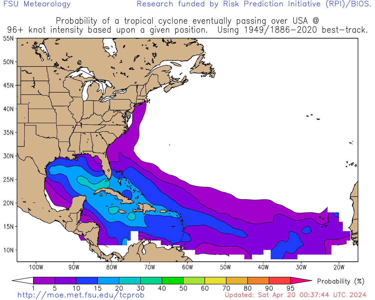
https://i.imgur.com/umEuEri.png


I think there might be a slight problem with the location lol
0 likes   
Note: If I make a post that is brief. Please refer back to previous posts for the analysis or reasoning. I do not re-write/qoute what my initial post said each time.
If there is nothing before... then just ask :)

Space & Atmospheric Physicist, Embry-Riddle Aeronautical University,
I believe the sky is falling...

Shell Mound
Category 5
Category 5
Posts: 2434
Age: 32
Joined: Thu Sep 07, 2017 3:39 pm
Location: St. Petersburg, FL → Scandinavia

Re: ATL: INVEST 98L - Discussion

#112 Postby Shell Mound » Tue Aug 18, 2020 8:17 am

 https://twitter.com/pppapin/status/1295413537905483776


 https://twitter.com/AndyHazelton/status/1295706243756163075


As an aside, the feature to its east is already detaching itself from the ITCZ, so perhaps that area could become dominant over time, resulting in a slower speed. Perhaps a dominant centre may consolidate farther to the east and then 98L will be absorbed by prospective 99L. This could also affect the future evolution of the track, as a slower, deeper (stronger) system, being more vertically stacked, may also allow ridging to build beneath the trough over the Eastern Seaboard and result in a greater threat to South FL and the eastern Gulf of Mexico. Additionally, the following image, taken from this source, is interesting, given that 98L is juxtaposed with a probability maximum in mid to late August:

Image
Last edited by Shell Mound on Tue Aug 18, 2020 8:31 am, edited 1 time in total.
0 likes   
CVW / MiamiensisWx / Shell Mound
The posts in this forum are NOT official forecasts and should not be used as such. They are just the opinion of the poster and may or may not be backed by sound meteorological data. They are NOT endorsed by any professional institution or STORM2K. For official information, please refer to products from the NHC and NWS.

User avatar
msbee
S2K Supporter
S2K Supporter
Posts: 3027
Joined: Wed Jun 11, 2003 10:11 am
Location: St. Maarten

Re: ATL: INVEST 98L - Discussion

#113 Postby msbee » Tue Aug 18, 2020 8:30 am

Good morning everyone
what are your thoughts on what effects thus will have on the northern Caribbean islands ?
I know its too early to tell but I would appreciate your thoughts. thanks
3 likes   
Too many hurricanes to remember

sma10
Category 5
Category 5
Posts: 1710
Joined: Tue Aug 02, 2005 1:13 pm

Re: ATL: INVEST 98L - Discussion

#114 Postby sma10 » Tue Aug 18, 2020 8:33 am

Between microscopic Gonzalo, gargantuan-sized Isaias wave, and now this two-headed monster, this has been the weirdest season in memory
5 likes   

User avatar
wxman57
Moderator-Pro Met
Moderator-Pro Met
Posts: 22973
Age: 67
Joined: Sat Jun 21, 2003 8:06 pm
Location: Houston, TX (southwest)

Re: ATL: INVEST 98L - Discussion

#115 Postby wxman57 » Tue Aug 18, 2020 8:36 am

You can't put out a 7-day track forecast saying "a general WNW motion" (that's pretty obvious). A 7-day track requires precise lat/lon points, intensity, and wind radii. Throwing out all model guidance isn't a solution. The GFS/Euro and ensembles came into much better agreement with the 00Z run. They're both indicating building high pressure to its north as it passes the NE Caribbean Fri PM/Sat. That could drive the center right across the DR & Cuba Sun/Mon rather than allow a track toward/into the Bahamas. Such a track would keep it week, likely a depression if/when it reaches the Gulf early next week.

Another possibility is that the high to the north Fri/Sat is weaker, allowing a track north of the Greater Antilles and toward the Bahamas. This would allow for a much stronger storm system threatening Florida or the SE U.S. Coast north of Florida early next week. Maybe even a northward turn off the coast.

Unfortunately, I cannot put 2-3 different tracks on my forecast. Current consensus is across the Greater Antilles, so that's the best choice to start with.
6 likes   

User avatar
wxman57
Moderator-Pro Met
Moderator-Pro Met
Posts: 22973
Age: 67
Joined: Sat Jun 21, 2003 8:06 pm
Location: Houston, TX (southwest)

Re: ATL: INVEST 98L - Discussion

#116 Postby wxman57 » Tue Aug 18, 2020 8:52 am

msbee wrote:Good morning everyone
what are your thoughts on what effects thus will have on the northern Caribbean islands ?
I know its too early to tell but I would appreciate your thoughts. thanks


At the very least, some heavy rain and gusty wind Friday night and Saturday as it passes, quite possibly as a 40-50 mph TS. If it passes to your north then you won't get much wind.
1 likes   

Aric Dunn
Category 5
Category 5
Posts: 21238
Age: 42
Joined: Sun Sep 19, 2004 9:58 pm
Location: Ready for the Chase.
Contact:

Re: ATL: INVEST 98L - Discussion

#117 Postby Aric Dunn » Tue Aug 18, 2020 8:57 am

wxman57 wrote:You can't put out a 7-day track forecast saying "a general WNW motion" (that's pretty obvious). A 7-day track requires precise lat/lon points, intensity, and wind radii. Throwing out all model guidance isn't a solution. The GFS/Euro and ensembles came into much better agreement with the 00Z run. They're both indicating building high pressure to its north as it passes the NE Caribbean Fri PM/Sat. That could drive the center right across the DR & Cuba Sun/Mon rather than allow a track toward/into the Bahamas. Such a track would keep it week, likely a depression if/when it reaches the Gulf early next week.

Another possibility is that the high to the north Fri/Sat is weaker, allowing a track north of the Greater Antilles and toward the Bahamas. This would allow for a much stronger storm system threatening Florida or the SE U.S. Coast north of Florida early next week. Maybe even a northward turn off the coast.

Unfortunately, I cannot put 2-3 different tracks on my forecast. Current consensus is across the Greater Antilles, so that's the best choice to start with.


you just gave a right extreme and left extreme and went down the middle.. otherwise known as a "Cone of Uncertainty"

this, of course, is barring any major rotational interaction ( Fujiwara of sorts) between the two features for which models historically fail at every time and would potentially cause drastic shifts if the overall position of both features. So again until the two features fates are resolved and a single-center is established, anything other than a WNW motion for the next 48 hours is futile.

Also having precise lat/lon points inside the "cone" is not required. it is by convention only.
2 likes   
Note: If I make a post that is brief. Please refer back to previous posts for the analysis or reasoning. I do not re-write/qoute what my initial post said each time.
If there is nothing before... then just ask :)

Space & Atmospheric Physicist, Embry-Riddle Aeronautical University,
I believe the sky is falling...

User avatar
Blown Away
S2K Supporter
S2K Supporter
Posts: 10145
Joined: Wed May 26, 2004 6:17 am

Re: ATL: INVEST 98L - Discussion

#118 Postby Blown Away » Tue Aug 18, 2020 9:14 am

Image
Definite broad circulation just N of 10N and W of of 38W
4 likes   
Hurricane Eye Experience: David 79, Irene 99, Frances 04, Jeanne 04, Wilma 05... EYE COMING MY WAY IN 2024…
Hurricane Brush Experience: Andrew 92, Erin 95, Floyd 99, Matthew 16, Irma 17, Ian 22, Nicole 22…

User avatar
NDG
S2K Supporter
S2K Supporter
Posts: 15446
Joined: Sun Jul 09, 2006 10:14 pm
Location: Orlando, FL

Re: ATL: INVEST 98L - Discussion

#119 Postby NDG » Tue Aug 18, 2020 9:18 am

wxman57 wrote:You can't put out a 7-day track forecast saying "a general WNW motion" (that's pretty obvious). A 7-day track requires precise lat/lon points, intensity, and wind radii. Throwing out all model guidance isn't a solution. The GFS/Euro and ensembles came into much better agreement with the 00Z run. They're both indicating building high pressure to its north as it passes the NE Caribbean Fri PM/Sat. That could drive the center right across the DR & Cuba Sun/Mon rather than allow a track toward/into the Bahamas. Such a track would keep it week, likely a depression if/when it reaches the Gulf early next week.

Another possibility is that the high to the north Fri/Sat is weaker, allowing a track north of the Greater Antilles and toward the Bahamas. This would allow for a much stronger storm system threatening Florida or the SE U.S. Coast north of Florida early next week. Maybe even a northward turn off the coast.

Unfortunately, I cannot put 2-3 different tracks on my forecast. Current consensus is across the Greater Antilles, so that's the best choice to start with.


Great post!
0 likes   

Aric Dunn
Category 5
Category 5
Posts: 21238
Age: 42
Joined: Sun Sep 19, 2004 9:58 pm
Location: Ready for the Chase.
Contact:

Re: ATL: INVEST 98L - Discussion

#120 Postby Aric Dunn » Tue Aug 18, 2020 9:21 am

A rough outline from piecing together the ASCAT passes from a couple of hours ago.

Definitely some interaction between the two lobes. This will lead to some likely interesting short term motions.

So just sit back and enjoy the next 48 hours ..

Image
7 likes   
Note: If I make a post that is brief. Please refer back to previous posts for the analysis or reasoning. I do not re-write/qoute what my initial post said each time.
If there is nothing before... then just ask :)

Space & Atmospheric Physicist, Embry-Riddle Aeronautical University,
I believe the sky is falling...


Return to “2020”

Who is online

Users browsing this forum: No registered users and 4 guests