ATL: ZETA - Post-Tropical - Discussion
Moderator: S2k Moderators
-
HurricaneEnzo

- Category 2

- Posts: 744
- Joined: Wed Mar 14, 2018 12:18 pm
- Location: Newport, NC (Hurricane Alley)
Re: ATL: INVEST 95L - Discussion
Not sure how strong this gets but I think we will have a TS at some point tomorrow.
1 likes
Bertha 96' - Fran 96' - Bonnie 98' - Dennis 99' - Floyd 99' - Isabel 03' - Alex 04' - Ophelia 05' - Irene 11' - Arthur 14' - Matthew 16' - Florence 18' - Dorian 19' - Isaias 20' (countless other tropical storms and Hurricane swipes)
I am not a Professional Met just an enthusiast. Get your weather forecasts from the Pros!
I am not a Professional Met just an enthusiast. Get your weather forecasts from the Pros!
-
cycloneye

- Admin

- Posts: 149505
- Age: 69
- Joined: Thu Oct 10, 2002 10:54 am
- Location: San Juan, Puerto Rico
Re: ATL: INVEST 95L - Discussion
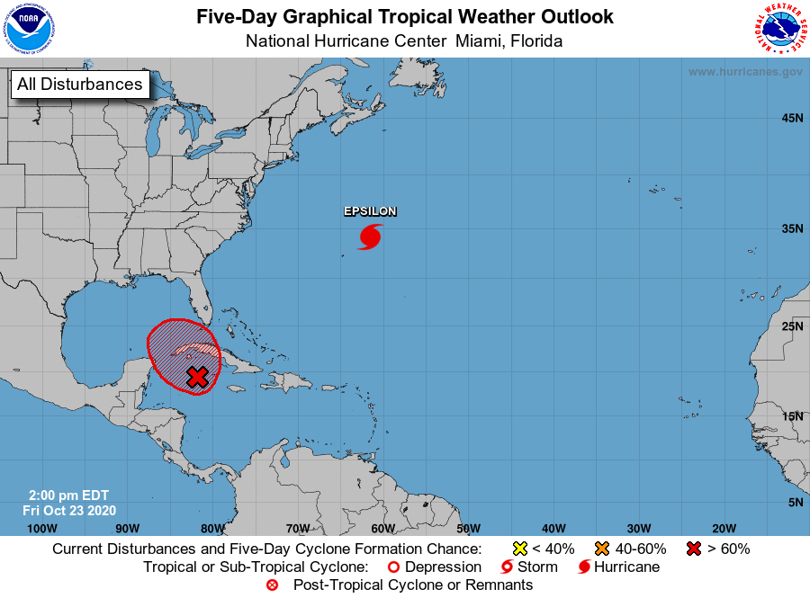
Code Red 70%/70%
Tropical Weather Outlook
NWS National Hurricane Center Miami FL
200 PM EDT Fri Oct 23 2020
For the North Atlantic...Caribbean Sea and the Gulf of Mexico:
The National Hurricane Center is issuing advisories on Hurricane
Epsilon, located over the west-central Atlantic a couple of hundred
miles northeast of Bermuda.
Satellite images and radar data indicate that the broad area of low
pressure located just west of Grand Cayman Island is gradually
becoming better defined. Environmental conditions appear conducive
for further development, and a tropical depression will likely form
during the next day or two while the low drifts toward the
northwest. The system could move near western Cuba by Sunday and
move slowly across the southeastern Gulf of Mexico by early next
week. Interests in western Cuba, the Florida Keys, and southern
Florida should monitor the progress of this disturbance. Regardless
of development, locally heavy rainfall will be possible over
portions of the Cayman Islands, Jamaica, Cuba, southern Florida,
the Florida Keys, and the northwestern Bahamas through the weekend.
* Formation chance through 48 hours...high...70 percent.
* Formation chance through 5 days...high...70 percent.
$$
Forecaster Blake/Papin
3 likes
Visit the Caribbean-Central America Weather Thread where you can find at first post web cams,radars
and observations from Caribbean basin members Click Here
and observations from Caribbean basin members Click Here
-
SFLcane

- S2K Supporter

- Posts: 10281
- Age: 48
- Joined: Sat Jun 05, 2010 1:44 pm
- Location: Lake Worth Florida
Re: ATL: INVEST 95L - Discussion
Wow 70% 70% this is going fast folks!
Last edited by SFLcane on Fri Oct 23, 2020 12:47 pm, edited 1 time in total.
0 likes
-
gatorcane

- S2K Supporter
- Posts: 23708
- Age: 48
- Joined: Sun Mar 13, 2005 3:54 pm
- Location: Boca Raton, FL
Re: ATL: INVEST 95L - Discussion
cycloneye wrote:Code Red 70%/70%Tropical Weather Outlook
NWS National Hurricane Center Miami FL
200 PM EDT Fri Oct 23 2020
For the North Atlantic...Caribbean Sea and the Gulf of Mexico:
The National Hurricane Center is issuing advisories on Hurricane
Epsilon, located over the west-central Atlantic a couple of hundred
miles northeast of Bermuda.
Satellite images and radar data indicate that the broad area of low
pressure located just west of Grand Cayman Island is gradually
becoming better defined. Environmental conditions appear conducive
for further development, and a tropical depression will likely form
during the next day or two while the low drifts toward the
northwest. The system could move near western Cuba by Sunday and
move slowly across the southeastern Gulf of Mexico by early next
week. Interests in western Cuba, the Florida Keys, and southern
Florida should monitor the progress of this disturbance. Regardless
of development, locally heavy rainfall will be possible over
portions of the Cayman Islands, Jamaica, Cuba, southern Florida,
the Florida Keys, and the northwestern Bahamas through the weekend.
* Formation chance through 48 hours...high...70 percent.
* Formation chance through 5 days...high...70 percent.
$$
Forecaster Blake/Papin
1 likes
-
northjaxpro

- S2K Supporter
- Posts: 8900
- Joined: Mon Sep 27, 2010 11:21 am
- Location: Jacksonville, FL
Re: ATL: INVEST 95L - Discussion
I am not surprised at all at 70% development. The next 3-5 days, 95L will be moving in tandem with an anticyclone, which will keep decent upper level over it for potential development. Plus, 95L will be traversing over and near the very warm ssts just south of Cuba this weekend. This area features the warmest water in the North Atlantic basin currently. I actually am expecting this system to attain Tropical Storm status as early as Saturday evening near the western tip of Cuba.
Last edited by northjaxpro on Fri Oct 23, 2020 12:59 pm, edited 2 times in total.
2 likes
NEVER, EVER SAY NEVER in the tropics and weather in general, and most importantly, with life itself!!
________________________________________________________________________________________
Fay 2008 Beryl 2012 Debby 2012 Colin 2016 Hermine 2016 Julia 2016 Matthew 2016 Irma 2017 Dorian 2019
________________________________________________________________________________________
Fay 2008 Beryl 2012 Debby 2012 Colin 2016 Hermine 2016 Julia 2016 Matthew 2016 Irma 2017 Dorian 2019

Re: ATL: INVEST 95L - Discussion
LLC is not as well organized as it was last night. To me it is a sign that is reorganizing.

1 likes
-
gfsperpendicular

- Category 1

- Posts: 383
- Age: 21
- Joined: Mon Jun 19, 2017 3:04 pm
- Location: Northern Virginia
Re: ATL: INVEST 95L - Discussion
NDG wrote:LLC is not as well organized as it was last night. To me it is a sign that is reorganizing.
https://i.imgur.com/8AiBWbL.jpg
ASCAT-C just one hour later tells an entirely different story.

5 likes
I'm not sleeping, I'm waiting for the 0900 UTC advisory!
#1 CMC stan
#1 CMC stan
-
northjaxpro
- S2K Supporter
- Posts: 8900
- Joined: Mon Sep 27, 2010 11:21 am
- Location: Jacksonville, FL
Re: ATL: INVEST 95L - Discussion
0 likes
NEVER, EVER SAY NEVER in the tropics and weather in general, and most importantly, with life itself!!
________________________________________________________________________________________
Fay 2008 Beryl 2012 Debby 2012 Colin 2016 Hermine 2016 Julia 2016 Matthew 2016 Irma 2017 Dorian 2019
________________________________________________________________________________________
Fay 2008 Beryl 2012 Debby 2012 Colin 2016 Hermine 2016 Julia 2016 Matthew 2016 Irma 2017 Dorian 2019
-
AutoPenalti
- Category 5

- Posts: 4091
- Age: 29
- Joined: Mon Aug 17, 2015 4:16 pm
- Location: Ft. Lauderdale, Florida
Re: ATL: INVEST 95L - Discussion
This is intensifying in a hurry.
0 likes
The posts in this forum are NOT official forecasts and should not be used as such. They are just the opinion of the poster and may or may not be backed by sound meteorological data. They are NOT endorsed by any professional institution or STORM2K. For official information, please refer to products from the NHC and NWS.
Model Runs Cheat Sheet:
GFS (5:30 AM/PM, 11:30 AM/PM)
HWRF, GFDL, UKMET, NAVGEM (6:30-8:00 AM/PM, 12:30-2:00 AM/PM)
ECMWF (1:45 AM/PM)
TCVN is a weighted averaged
-
Weatherboy1

- Category 5
- Posts: 1190
- Age: 50
- Joined: Mon Jul 05, 2004 1:50 pm
- Location: Jupiter/Sarasota, FL
Re: ATL: INVEST 95L - Discussion
gatorcane wrote:cycloneye wrote:Code Red 70%/70%Tropical Weather Outlook
NWS National Hurricane Center Miami FL
200 PM EDT Fri Oct 23 2020
For the North Atlantic...Caribbean Sea and the Gulf of Mexico:
The National Hurricane Center is issuing advisories on Hurricane
Epsilon, located over the west-central Atlantic a couple of hundred
miles northeast of Bermuda.
Satellite images and radar data indicate that the broad area of low
pressure located just west of Grand Cayman Island is gradually
becoming better defined. Environmental conditions appear conducive
for further development, and a tropical depression will likely form
during the next day or two while the low drifts toward the
northwest. The system could move near western Cuba by Sunday and
move slowly across the southeastern Gulf of Mexico by early next
week. Interests in western Cuba, the Florida Keys, and southern
Florida should monitor the progress of this disturbance. Regardless
of development, locally heavy rainfall will be possible over
portions of the Cayman Islands, Jamaica, Cuba, southern Florida,
the Florida Keys, and the northwestern Bahamas through the weekend.
* Formation chance through 48 hours...high...70 percent.
* Formation chance through 5 days...high...70 percent.
$$
Forecaster Blake/Papin
https://i.postimg.cc/5y4cW89N/two-atl-5d0.png
Looking at the setup, modeling, time of year etc and a slightly modified version of that 1980s one-hit-wonder song comes to mind “C’mon Irene...”
2 likes

Re: ATL: INVEST 95L - Discussion
When forecastersare discussing weather, i I would appreciate it so much if they would specify the west coast or the east coast instead of simply saying South Florida.
0 likes
-
ElectricStorm

- Category 5
- Posts: 5147
- Age: 25
- Joined: Tue Aug 13, 2019 11:23 pm
- Location: Norman, OK
Re: ATL: INVEST 95L - Discussion
The way this is coming together, I think this has a chance to get stronger than what the models are showing. Will need to be watched for sure
0 likes
B.S Meteorology, University of Oklahoma '25
Please refer to the NHC, NWS, or SPC for official information.
Please refer to the NHC, NWS, or SPC for official information.

Re: ATL: INVEST 95L - Discussion
northjaxpro wrote:I am not surprised at all at 70% development. The next 3-5 days, 95L will be moving in tandem with an anticyclone, which will keep decent upper level over it for potential development. Plus, 95L will be traversing over and near the very warm ssts just south of Cuba this weekend. This area features the warmest water in the North Atlantic basin currently. I actually am expecting this system to attain Tropical Storm status as early as Saturday evening near the western tip of Cuba.
Quickly getting itself together with an anticyclone on top and staying within the warmest waters of the basin for up to 4 days (depending on the track)...oh boy. Maybe we will get an intense Zeta or an Irene ‘99 analogue out of this after all.
0 likes
Irene '11 Sandy '12 Hermine '16 5/15/2018 Derecho Fay '20 Isaias '20 Elsa '21 Henri '21 Ida '21
I am only a meteorology enthusiast who knows a decent amount about tropical cyclones. Look to the professional mets, the NHC, or your local weather office for the best information.
I am only a meteorology enthusiast who knows a decent amount about tropical cyclones. Look to the professional mets, the NHC, or your local weather office for the best information.
-
northjaxpro
- S2K Supporter
- Posts: 8900
- Joined: Mon Sep 27, 2010 11:21 am
- Location: Jacksonville, FL
Re: ATL: INVEST 95L - Discussion
aspen wrote:northjaxpro wrote:I am not surprised at all at 70% development. The next 3-5 days, 95L will be moving in tandem with an anticyclone, which will keep decent upper level over it for potential development. Plus, 95L will be traversing over and near the very warm ssts just south of Cuba this weekend. This area features the warmest water in the North Atlantic basin currently. I actually am expecting this system to attain Tropical Storm status as early as Saturday evening near the western tip of Cuba.
Quickly getting itself together with an anticyclone on top and staying within the warmest waters of the basin for up to 4 days (depending on the track)...oh boy. Maybe we will get an intense Zeta or an Irene ‘99 analogue out of this after all.
It is definitely a possibility.
0 likes
NEVER, EVER SAY NEVER in the tropics and weather in general, and most importantly, with life itself!!
________________________________________________________________________________________
Fay 2008 Beryl 2012 Debby 2012 Colin 2016 Hermine 2016 Julia 2016 Matthew 2016 Irma 2017 Dorian 2019
________________________________________________________________________________________
Fay 2008 Beryl 2012 Debby 2012 Colin 2016 Hermine 2016 Julia 2016 Matthew 2016 Irma 2017 Dorian 2019
Re: ATL: INVEST 95L - Discussion
sunnyday wrote:When forecastersare discussing weather, i I would appreciate it so much if they would specify the west coast or the east coast instead of simply saying South Florida.
??? south florida is a thin strip of mostly swamp. you have an increasing likelihood of a ts moving over or close to s florida and the keys on a northeasterly heading. western cuba has been a hot zone for TCs. a decent chance for a south florida impact here.
0 likes
-
Aric Dunn
- Category 5
- Posts: 21238
- Age: 43
- Joined: Sun Sep 19, 2004 9:58 pm
- Location: Ready for the Chase.
- Contact:
Re: ATL: INVEST 95L - Discussion
the 150mile radar range. 2 hours saved. a little clearer... center is very quickly consolidating and organizing with that convection right around Grand cayman.

5 likes
Note: If I make a post that is brief. Please refer back to previous posts for the analysis or reasoning. I do not re-write/qoute what my initial post said each time.
If there is nothing before... then just ask
Space & Atmospheric Physicist, Embry-Riddle Aeronautical University,
I believe the sky is falling...
If there is nothing before... then just ask
Space & Atmospheric Physicist, Embry-Riddle Aeronautical University,
I believe the sky is falling...
-
Evil Jeremy

- S2K Supporter
- Posts: 5463
- Age: 32
- Joined: Mon Apr 10, 2006 2:10 pm
- Location: Los Angeles, CA
Re: ATL: INVEST 95L - Discussion
Is it safe to assume that the quicker this organizes, the more north it could be drawn before the shortwave exits and ridge builds back?
2 likes
Frances 04 / Jeanne 04 / Katrina 05 / Wilma 05 / Fay 08 / Debby 12 / Andrea 13 / Colin 16 / Hermine 16 / Matthew 16 / Irma 17
-
SouthFLTropics

- Category 5
- Posts: 4258
- Age: 50
- Joined: Thu Aug 14, 2003 8:04 am
- Location: Port St. Lucie, Florida
Re: ATL: INVEST 95L - Discussion
Evil Jeremy wrote:Is it safe to assume that the quicker this organizes, the more north it could be drawn before the shortwave exits and ridge builds back?
I think that's a reasonable assumption. I think there is a possible concern that we could end up with a strengthening TC off the North coast of Cuba in the Central Bahamas and ready to make a turn to the NW or WNW as the ridge builds in.
2 likes
Fourth Generation Florida Native
Personal Storm History: David 79, Andrew 92, Erin 95, Floyd 99, Irene 99, Frances 04, Jeanne 04, Wilma 05, Matthew 16, Irma 17, Ian 22, Nicole 22, Milton 24
Personal Storm History: David 79, Andrew 92, Erin 95, Floyd 99, Irene 99, Frances 04, Jeanne 04, Wilma 05, Matthew 16, Irma 17, Ian 22, Nicole 22, Milton 24

Re: ATL: INVEST 95L - Discussion
gfsperpendicular wrote:NDG wrote:LLC is not as well organized as it was last night. To me it is a sign that is reorganizing.
https://i.imgur.com/8AiBWbL.jpg
ASCAT-C just one hour later tells an entirely different story.
https://media.discordapp.net/attachments/765039770606370877/769257356193955920/LATEST.png?width=564&height=564
Well that explains the jump to 70%. Getting very interesting now.
0 likes
The following post is NOT an official forecast and should not be used as such. It is just the opinion of the poster and may or may not be backed by sound meteorological data. It is NOT endorsed by any professional institution including storm2k.org For Official Information please refer to the NHC and NWS products.
-
gatorcane
- S2K Supporter
- Posts: 23708
- Age: 48
- Joined: Sun Mar 13, 2005 3:54 pm
- Location: Boca Raton, FL
Re: ATL: INVEST 95L - Discussion
Is coming together pretty quickly. Models playing catch-up as usual. Might see a center reformation further SE of where NHC has it.
3 likes
Who is online
Users browsing this forum: No registered users and 99 guests