ATL: ISAIAS - Post-Tropical - Discussion
Moderator: S2k Moderators
-
SFLcane

- S2K Supporter

- Posts: 10281
- Age: 48
- Joined: Sat Jun 05, 2010 1:44 pm
- Location: Lake Worth Florida
Re: ATL: NINE - Potential Tropical Cyclone - Discussion
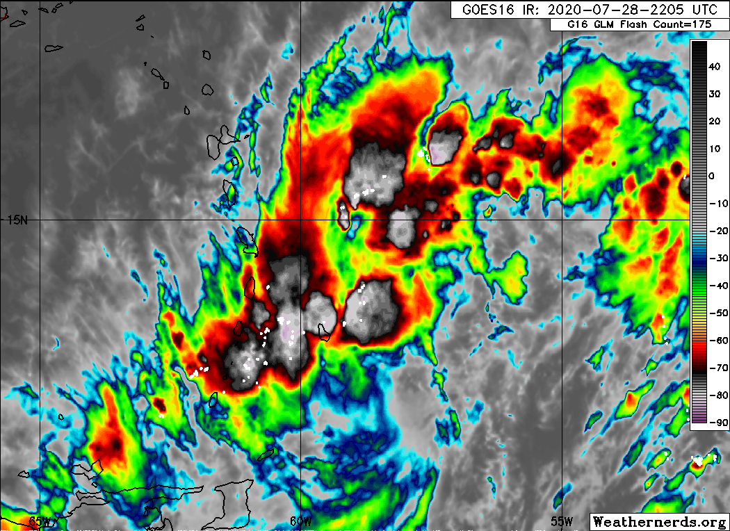
By far the deepest convection I’ve seen with PT9.
10 likes
-
DestinHurricane

- Category 4

- Posts: 935
- Joined: Tue May 01, 2018 8:05 am
- Location: New York, NY
Re: ATL: NINE - Potential Tropical Cyclone - Discussion
Martinique looks like its going to get some severe storms soon.
2 likes
Michael 2018
-
ScottNAtlanta

- Category 5

- Posts: 2535
- Joined: Sat May 25, 2013 3:11 pm
- Location: Atlanta, GA
Re: ATL: NINE - Potential Tropical Cyclone - Discussion
I'm just not seeing this North component of the wnw movement. Of course, it is hard to track movement of a center that does not exist yet.
1 likes
The posts in this forum are NOT official forecast and should not be used as such. They are just the opinion of the poster and may or may not be backed by sound meteorological data. They are NOT endorsed by any professional institution or storm2k.org. For official information, please refer to the NHC and NWS products.

Re: ATL: NINE - Potential Tropical Cyclone - Discussion
Recon is heading out around midnight, correct?
I’m gonna have a long night tonight.
I’m gonna have a long night tonight.
3 likes
Irene '11 Sandy '12 Hermine '16 5/15/2018 Derecho Fay '20 Isaias '20 Elsa '21 Henri '21 Ida '21
I am only a meteorology enthusiast who knows a decent amount about tropical cyclones. Look to the professional mets, the NHC, or your local weather office for the best information.
I am only a meteorology enthusiast who knows a decent amount about tropical cyclones. Look to the professional mets, the NHC, or your local weather office for the best information.
-
SFLcane
- S2K Supporter
- Posts: 10281
- Age: 48
- Joined: Sat Jun 05, 2010 1:44 pm
- Location: Lake Worth Florida
Re: ATL: NINE - Potential Tropical Cyclone - Discussion
With the new center relocated not much will be left if this crosses over DR. 00z guidance implies just that
0 likes
-
plasticup
Re: ATL: NINE - Potential Tropical Cyclone - Discussion
SFLcane wrote:With the new center relocated not much will be left if this crosses over DR. 00z guidance implies just that
Hispaniola is always a wild card - doesn't take much of a shift to miss it altogether.
3 likes
-
SouthFloridawx

- S2K Supporter
- Posts: 8346
- Age: 47
- Joined: Tue Jul 26, 2005 1:16 am
- Location: Sarasota, FL
- Contact:
Re: ATL: NINE - Potential Tropical Cyclone - Discussion
I think this thing is going into the Caribbean. It's moving at 25mph with center reformations happening all the time. It's a really large broad area. Those take a little while to get going.
3 likes
-
SapphireSea
- Category 1

- Posts: 430
- Joined: Wed Aug 24, 2005 12:13 pm
- Location: Miami, FL
Re: ATL: NINE - Potential Tropical Cyclone - Discussion
Shear analysis does not look good. Alot of this powerful convection could be related to high shear and convergence. The rapidly ascending towers and movement of the towers seems to be to indicate this. Normally that shear is related to the outflow of the storm, but the 35KT analysis existed even before the storm could enter to influence that area. I would say it's entering a strong shear zone.
http://tropic.ssec.wisc.edu/real-time/a ... wg8shr.GIF
http://tropic.ssec.wisc.edu/real-time/a ... wg8shr.GIF
2 likes


Re: ATL: NINE - Potential Tropical Cyclone - Discussion
3 likes
Large Signatures are for losers.
The posts in this forum are NOT official forecasts and should not be used as such. They are just the opinion of the poster and may or may not be backed by sound meteorological data. They are NOT endorsed by any professional institution or STORM2K. For official information, please refer to products from the NHC and NWS.
-
Aric Dunn
- Category 5
- Posts: 21238
- Age: 43
- Joined: Sun Sep 19, 2004 9:58 pm
- Location: Ready for the Chase.
- Contact:
Re: ATL: NINE - Potential Tropical Cyclone - Discussion
Center appears even Farther south.. per new ASCAT .. under that MLC>
now things get interesting.

now things get interesting.
2 likes
Note: If I make a post that is brief. Please refer back to previous posts for the analysis or reasoning. I do not re-write/qoute what my initial post said each time.
If there is nothing before... then just ask
Space & Atmospheric Physicist, Embry-Riddle Aeronautical University,
I believe the sky is falling...
If there is nothing before... then just ask
Space & Atmospheric Physicist, Embry-Riddle Aeronautical University,
I believe the sky is falling...
-
Do_For_Love
- Category 1
- Posts: 271
- Age: 35
- Joined: Sat May 09, 2015 7:47 am
- Location: Delaware
Re: ATL: NINE - Potential Tropical Cyclone - Discussion
SFLcane wrote:By far the deepest convection I’ve seen with PT9.
No doubt. The storms over those islands look pretty wicked right now.
3 likes
Irene '11, Sandy '12, Fay '20, Isaias '20, Ida '21
-
Aric Dunn
- Category 5
- Posts: 21238
- Age: 43
- Joined: Sun Sep 19, 2004 9:58 pm
- Location: Ready for the Chase.
- Contact:
Re: ATL: NINE - Potential Tropical Cyclone - Discussion
yeppers...

6 likes
Note: If I make a post that is brief. Please refer back to previous posts for the analysis or reasoning. I do not re-write/qoute what my initial post said each time.
If there is nothing before... then just ask
Space & Atmospheric Physicist, Embry-Riddle Aeronautical University,
I believe the sky is falling...
If there is nothing before... then just ask
Space & Atmospheric Physicist, Embry-Riddle Aeronautical University,
I believe the sky is falling...
-
HurricaneFrances04
- Category 2

- Posts: 597
- Joined: Mon Jun 25, 2012 8:09 am
- Location: Fort Lauderdale, Florida

Re: ATL: NINE - Potential Tropical Cyclone - Discussion
Actually a windgust of 105 KLM/ in Martinique and very strong thunderstorms
6 likes
-
Aric Dunn
- Category 5
- Posts: 21238
- Age: 43
- Joined: Sun Sep 19, 2004 9:58 pm
- Location: Ready for the Chase.
- Contact:
Re: ATL: NINE - Potential Tropical Cyclone - Discussion
00z models are going to be interesting... these ASCAT passes should make it in them. with it that far south..
1 likes
Note: If I make a post that is brief. Please refer back to previous posts for the analysis or reasoning. I do not re-write/qoute what my initial post said each time.
If there is nothing before... then just ask
Space & Atmospheric Physicist, Embry-Riddle Aeronautical University,
I believe the sky is falling...
If there is nothing before... then just ask
Space & Atmospheric Physicist, Embry-Riddle Aeronautical University,
I believe the sky is falling...

Re: ATL: NINE - Potential Tropical Cyclone - Discussion
Aric Dunn wrote:00z models are going to be interesting... these ASCAT passes should make it in them. with it that far south..
Did recon collect data for the 00z suite tonight?
0 likes
-
HurricaneFrances04
- Category 2
- Posts: 597
- Joined: Mon Jun 25, 2012 8:09 am
- Location: Fort Lauderdale, Florida
Re: ATL: NINE - Potential Tropical Cyclone - Discussion
It looks like the GFS already lines up pretty well with that ASCAT pass

3 likes
-
SFLcane
- S2K Supporter
- Posts: 10281
- Age: 48
- Joined: Sat Jun 05, 2010 1:44 pm
- Location: Lake Worth Florida
Re: ATL: NINE - Potential Tropical Cyclone - Discussion
Aric Dunn wrote:00z models are going to be interesting... these ASCAT passes should make it in them. with it that far south..
More south=Land interaction
We shall see what though NHC intensity might be toned down further at 11.
1 likes

Re: ATL: NINE - Potential Tropical Cyclone - Discussion
plasticup wrote:SFLcane wrote:With the new center relocated not much will be left if this crosses over DR. 00z guidance implies just that
Hispaniola is always a wild card - doesn't take much of a shift to miss it altogether.
Correct, with a possible new center forming down near 12.5N & 58.5W, there'll be plenty of time to start speculating where this beast might go. Boy, will it be nuts if that occurs. Talk about changing things up.
3 likes
Andy D
(For official information, please refer to the NHC and NWS products.)
(For official information, please refer to the NHC and NWS products.)
Re: ATL: NINE - Potential Tropical Cyclone - Discussion
STRiZZY wrote:Aric Dunn wrote:00z models are going to be interesting... these ASCAT passes should make it in them. with it that far south..
Did recon collect data for the 00z suite tonight?
That is in a few hours, that recon data will not be used for the 00z run, only for the 06z run. So early bird get's the worm and the good data.
1 likes
Large Signatures are for losers.
The posts in this forum are NOT official forecasts and should not be used as such. They are just the opinion of the poster and may or may not be backed by sound meteorological data. They are NOT endorsed by any professional institution or STORM2K. For official information, please refer to products from the NHC and NWS.
Who is online
Users browsing this forum: No registered users and 95 guests