ATL: DELTA - Post-Tropical - Discussion

Moderator: S2k Moderators

Message
Author
User avatar
Cataegis96
Professional-Met
Professional-Met
Posts: 54
Age: 29
Joined: Mon Jul 10, 2017 3:46 pm
Contact:

Re: ATL: DELTA - Hurricane - Discussion

#1201 Postby Cataegis96 » Tue Oct 06, 2020 2:02 pm

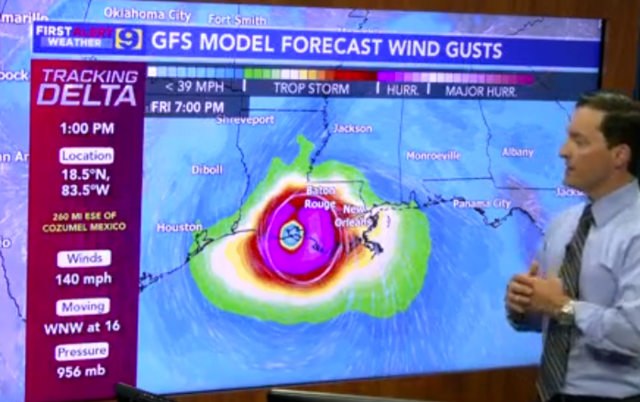
GCANE wrote:Interesting on IR.
Appears a lead rotating hot tower smacked head on to the eyewall and is now reforming the eye.


Definitely some strange structural changes going on all of a sudden. It seems like this may be the trigger for the pinhole eye to really break through. Must be absolutely nuts inside that core right now.
9 likes   
Lead Meteorologist Mars, Inc
WE ARE! The Pennsylvania State University 2018
UA U KNOW! University at Albany, SUNY 2020

User avatar
MississippiWx
S2K Supporter
S2K Supporter
Posts: 1699
Joined: Sat Aug 14, 2010 1:44 pm
Location: Hattiesburg, Mississippi

Re: ATL: DELTA - Hurricane - Discussion

#1202 Postby MississippiWx » Tue Oct 06, 2020 2:07 pm

The flat, convection-less eastern half of the circulation is a telling sign that there is some easterly shear affecting Delta. It obviously hasn’t kept it from strengthening but I’m wondering if that has put a temporary limit on strength. Recon will tell.
1 likes   
This post is not an official forecast and should not be used as such. It is just the opinion of MississippiWx and may or may not be backed by sound meteorological data. It is not endorsed by any professional institution including storm2k.org. For Official Information please refer to the NHC and NWS products.

User avatar
cheezyWXguy
Category 5
Category 5
Posts: 6108
Joined: Mon Feb 13, 2006 12:29 am
Location: Dallas, TX

Re: ATL: DELTA - Hurricane - Discussion

#1203 Postby cheezyWXguy » Tue Oct 06, 2020 2:08 pm

How on earth do you get an overshooting top above -80 to -90C cloud tops?
0 likes   

User avatar
Steve
S2K Supporter
S2K Supporter
Posts: 9621
Joined: Sat Apr 05, 2003 11:41 pm
Location: Not a state-caster

Re: ATL: DELTA - Hurricane - Discussion

#1204 Postby Steve » Tue Oct 06, 2020 2:19 pm

Stormgodess wrote:
Nimbus wrote:
Javlin wrote:

Have to agree Steve strange setup looking at this sat of the GOM looks like Gamma is calling Delta come get me.

https://www.tropicaltidbits.com/sat/sat ... =truecolor


Gamma is a 1000 mile wide cylinder of air rotating counter clockwise not just a blip.
200 mb layer got blown off by sheer and inflow will get pulled out from underneath fairly quickly as the two get closer but there is still remnant steering.
06z HWRF was showing Delta tracking about a half degree further west due to remnant environmental rotation.

Maybe we will learn something about the Fujiwara effect from remnant systems?


Being a total noob, just looking at that loop, logic is telling me that gamma would possibly spin Delta around itself arching her more east then arching west once Delta is north of Gamma?? Could that be what the European model is seeing too? and why its track is further west?

But also I truly have no idea of what Im talking about


It’s weird. We were talking about potential for interaction last week when we didn’t know if Delta or Gamma would become the dominant system. If you look at the link Javlin posted, you can see the feeders parallel with the TX Coast moving SSE toward the Mexican Coastline. I feel like the two systems are embedded in some kind of pocket (gyre) that itself is spinning counter clockwise. So a system to the north in that scenario would have to get pulled westward because the airmass overall is spinning cyclonically.
4 likes   

Astromanía
Category 2
Category 2
Posts: 779
Age: 26
Joined: Sat Aug 25, 2018 10:34 pm
Location: Monterrey, N.L, México

Re: ATL: DELTA - Hurricane - Discussion

#1205 Postby Astromanía » Tue Oct 06, 2020 2:22 pm

It's moving so fast, it would be worse if it moves very slow, right?
Last edited by Astromanía on Tue Oct 06, 2020 2:24 pm, edited 1 time in total.
2 likes   

User avatar
ConvergenceZone
Category 5
Category 5
Posts: 5194
Joined: Fri Jul 29, 2005 1:40 am
Location: Northern California

Re: ATL: DELTA - Hurricane - Discussion

#1206 Postby ConvergenceZone » Tue Oct 06, 2020 2:24 pm

Still impressive, but not looking quite as impressive as earlier...
Last edited by ConvergenceZone on Tue Oct 06, 2020 2:24 pm, edited 1 time in total.
0 likes   

User avatar
kevin
Category 5
Category 5
Posts: 2587
Age: 26
Joined: Wed Aug 28, 2019 4:35 am

Re: ATL: DELTA - Hurricane - Discussion

#1207 Postby kevin » Tue Oct 06, 2020 2:24 pm

Not sure what's happening here in the last 4 frames of the latest loop. Is it an eye trying to pop out?

0 likes   

User avatar
EquusStorm
Category 5
Category 5
Posts: 1649
Age: 34
Joined: Thu Nov 07, 2013 1:04 pm
Location: Jasper, AL
Contact:

Re: ATL: DELTA - Hurricane - Discussion

#1208 Postby EquusStorm » Tue Oct 06, 2020 2:24 pm

Suffice to say, I wouldn't want to be in a fishing boat under the RMW of this thing right now
2 likes   
Colors of lost purpose on the canvas of irrelevance

Not a meteorologist, in fact more of an idiot than anything. You should probably check with the NHC or a local NWS office for official information.

User avatar
MississippiWx
S2K Supporter
S2K Supporter
Posts: 1699
Joined: Sat Aug 14, 2010 1:44 pm
Location: Hattiesburg, Mississippi

Re: ATL: DELTA - Hurricane - Discussion

#1209 Postby MississippiWx » Tue Oct 06, 2020 2:33 pm

kevin wrote:Not sure what's happening here in the last 4 frames of the latest loop. Is it an eye trying to pop out?

https://imgur.com/iQrAsNs


Overshooting top/hot tower circulating around the eye. Still no sign of the eye on visible.
2 likes   
This post is not an official forecast and should not be used as such. It is just the opinion of MississippiWx and may or may not be backed by sound meteorological data. It is not endorsed by any professional institution including storm2k.org. For Official Information please refer to the NHC and NWS products.

User avatar
Texashawk
Category 2
Category 2
Posts: 579
Joined: Tue Aug 14, 2007 1:50 am
Location: Missouri City, TX (Houston)

Re: ATL: DELTA - Hurricane - Discussion

#1210 Postby Texashawk » Tue Oct 06, 2020 2:33 pm

Just saw the recon plan for tomorrow. I think the NHC is literally throwing every plane it has at this storm. Never seen such a full docket!
2 likes   

supercane4867
Category 5
Category 5
Posts: 4966
Joined: Wed Nov 14, 2012 10:43 am

Re: ATL: DELTA - Hurricane - Discussion

#1211 Postby supercane4867 » Tue Oct 06, 2020 2:33 pm

No signs of ERC yet on the fresh AMSR pass. Probably just the mid-shear that's holding it off.

Image
3 likes   

User avatar
GCANE
S2K Supporter
S2K Supporter
Posts: 11500
Joined: Mon Oct 22, 2007 8:03 am

Re: ATL: DELTA - Hurricane - Discussion

#1212 Postby GCANE » Tue Oct 06, 2020 2:36 pm

What an outlier

Image
10 likes   

User avatar
kevin
Category 5
Category 5
Posts: 2587
Age: 26
Joined: Wed Aug 28, 2019 4:35 am

Re: ATL: DELTA - Hurricane - Discussion

#1213 Postby kevin » Tue Oct 06, 2020 2:37 pm

GCANE wrote:What an outlier

https://i.imgur.com/bH76Jbb.png


Wow, that outlier is like a Patricia level monster. Just one model of course and way stronger than the others, but I don't think I've ever seen something like that in an intensity guidance. At least not for the Atlantic.
1 likes   

Fancy1001
Category 1
Category 1
Posts: 452
Joined: Thu Jul 16, 2020 10:16 pm

Re: ATL: DELTA - Hurricane - Discussion

#1214 Postby Fancy1001 » Tue Oct 06, 2020 2:39 pm

Whats the COTI model?
0 likes   

User avatar
MississippiWx
S2K Supporter
S2K Supporter
Posts: 1699
Joined: Sat Aug 14, 2010 1:44 pm
Location: Hattiesburg, Mississippi

Re: ATL: DELTA - Hurricane - Discussion

#1215 Postby MississippiWx » Tue Oct 06, 2020 2:40 pm

GCANE wrote:What an outlier

https://i.imgur.com/bH76Jbb.png


Lol. Wow.

I have never seen that for an Atlantic storm. :eek:
3 likes   
This post is not an official forecast and should not be used as such. It is just the opinion of MississippiWx and may or may not be backed by sound meteorological data. It is not endorsed by any professional institution including storm2k.org. For Official Information please refer to the NHC and NWS products.

User avatar
kevin
Category 5
Category 5
Posts: 2587
Age: 26
Joined: Wed Aug 28, 2019 4:35 am

Re: ATL: DELTA - Hurricane - Discussion

#1216 Postby kevin » Tue Oct 06, 2020 2:41 pm

Fancy1001 wrote:Whats the COTI model?


I think it's the same or similar to the CTCI model (someone correct me if I'm wrong), which NHC uses for track and intensity. But I can't imagine that intensity verifying, or at least I don't want to imagine it.

"CTCX/CTCI NRL COAMPS-TC w/ GFS initial and boundary conditions Nested Grid point (45-15-5 km) 42 Hybrid Sigma-pressure 3D-VAR (NAVDAS) EnKF DART Kain-Fritsch 6 hr (126 hr)
00/06/12/18 UTC
Runs commence on 1st NHC/JTWC advisory Track and intensity"
0 likes   

User avatar
GCANE
S2K Supporter
S2K Supporter
Posts: 11500
Joined: Mon Oct 22, 2007 8:03 am

Re: ATL: DELTA - Hurricane - Discussion

#1217 Postby GCANE » Tue Oct 06, 2020 2:43 pm

Cold pool may be stacking under the warm core now.
Area around it seems to be warmer now.
So, enthalpy flux from the water to the air maybe leveling off.
Wind speed / eye pressure may not change much until the upper troposphere starts to cool off in a few hours.

Image
0 likes   

User avatar
GCANE
S2K Supporter
S2K Supporter
Posts: 11500
Joined: Mon Oct 22, 2007 8:03 am

Re: ATL: DELTA - Hurricane - Discussion

#1218 Postby GCANE » Tue Oct 06, 2020 2:47 pm

0 likes   

User avatar
Stormgodess
Category 1
Category 1
Posts: 301
Joined: Mon Sep 14, 2020 1:31 am

Re: ATL: DELTA - Hurricane - Discussion

#1219 Postby Stormgodess » Tue Oct 06, 2020 2:47 pm

Dr Steve Caparotta our local Meteorologist just shared this. If one of yall could find a better image please share this is screen grab from a vid. But this is a scary model, wind field much wider

Image
2 likes   

User avatar
MississippiWx
S2K Supporter
S2K Supporter
Posts: 1699
Joined: Sat Aug 14, 2010 1:44 pm
Location: Hattiesburg, Mississippi

Re: ATL: DELTA - Hurricane - Discussion

#1220 Postby MississippiWx » Tue Oct 06, 2020 2:50 pm

Stormgodess wrote:Dr Steve Caparotta our local Meteorologist just shared this. If one of yall could find a better image please share this is screen grab from a vid. But this is a scary model, wind field much wider

https://i.postimg.cc/4dQNJjDF/D4.png


One bit of information that seems to be going largely unnoticed is how much Delta grows in the Gulf of Mexico. I’m Afraid people are looking at its current small size and extrapolating that to US landfall when models are showing it grow rather large.
Last edited by MississippiWx on Tue Oct 06, 2020 2:50 pm, edited 1 time in total.
4 likes   
This post is not an official forecast and should not be used as such. It is just the opinion of MississippiWx and may or may not be backed by sound meteorological data. It is not endorsed by any professional institution including storm2k.org. For Official Information please refer to the NHC and NWS products.


Return to “2020”

Who is online

Users browsing this forum: No registered users and 5 guests