ATL: ISAIAS - Models
Moderator: S2k Moderators
-
gatorcane

- S2K Supporter

- Posts: 23708
- Age: 48
- Joined: Sun Mar 13, 2005 3:54 pm
- Location: Boca Raton, FL
Re: ATL: NINE - Models
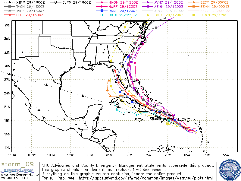
gatorcane wrote:TVCN skimming SE Florida. That's quite a bit east of the red line (NHC) track:
https://i.postimg.cc/MTdwHnbS/storm-09.gif
Also note that is not the 12Z Euro on this map so the TVCN is likely just east of Florida.
0 likes

Re: ATL: NINE - Models
Hd444 wrote:Irene 2.0 ?
Not yet; this might plow right through Florida or go into the Gulf. The models have been back and forth for the last few days and we don’t even have a good idea where the center of the storm is.
0 likes
Irene '11 Sandy '12 Hermine '16 5/15/2018 Derecho Fay '20 Isaias '20 Elsa '21 Henri '21 Ida '21
I am only a meteorology enthusiast who knows a decent amount about tropical cyclones. Look to the professional mets, the NHC, or your local weather office for the best information.
I am only a meteorology enthusiast who knows a decent amount about tropical cyclones. Look to the professional mets, the NHC, or your local weather office for the best information.
-
Aric Dunn
- Category 5

- Posts: 21238
- Age: 43
- Joined: Sun Sep 19, 2004 9:58 pm
- Location: Ready for the Chase.
- Contact:
Re: ATL: NINE - Models
my issue with the models is they start it moving wnw to almost NW right now.. and it refuses to do so.
to make it north of Hispaniola it would have to head NW to Borderline wnw ( unless it reformed and again no sign of that).. if we assuming the center is that convection south of PR
with that stout ridge to the north that just does not seem reasonable
to make it north of Hispaniola it would have to head NW to Borderline wnw ( unless it reformed and again no sign of that).. if we assuming the center is that convection south of PR
with that stout ridge to the north that just does not seem reasonable
2 likes
Note: If I make a post that is brief. Please refer back to previous posts for the analysis or reasoning. I do not re-write/qoute what my initial post said each time.
If there is nothing before... then just ask
Space & Atmospheric Physicist, Embry-Riddle Aeronautical University,
I believe the sky is falling...
If there is nothing before... then just ask
Space & Atmospheric Physicist, Embry-Riddle Aeronautical University,
I believe the sky is falling...
-
ScottNAtlanta

- Category 5
- Posts: 2535
- Joined: Sat May 25, 2013 3:11 pm
- Location: Atlanta, GA
Re: ATL: NINE - Models
Aric Dunn wrote:my issue with the models is they start it moving wnw to almost NW right now.. and it refuses to do so.
to make it north of Hispaniola it would have to head NW to Borderline wnw ( unless it reformed and again no sign of that).. if we assuming the center is that convection south of PR
with that stout ridge to the north that just does not seem reasonable
I agree. I have seen no inclination for this to make that kind of turn. I also think models are initializing this too far north. I think the center is forming near 15N 65W
1 likes
The posts in this forum are NOT official forecast and should not be used as such. They are just the opinion of the poster and may or may not be backed by sound meteorological data. They are NOT endorsed by any professional institution or storm2k.org. For official information, please refer to the NHC and NWS products.
-
jlauderdal
- S2K Supporter
- Posts: 7240
- Joined: Wed May 19, 2004 5:46 am
- Location: NE Fort Lauderdale
- Contact:
Re: ATL: NINE - Models
XTRP is even right sometimes....nhc has been left of guidance, will see if they stick with that. The have been really good with the track even at 5 days the last several years, this one is complex but I bet they are within 100 miles of the their 5 day point after tonights 11 pm.SFLcane wrote:You guys do realize that nogaps has been showing this track for days. Lol
0 likes
-
AxaltaRacing24
- Category 5
- Posts: 1774
- Age: 25
- Joined: Wed Jul 27, 2016 11:14 am
- Location: Jupiter, FL
Re: ATL: NINE - Models
Aric Dunn wrote:my issue with the models is they start it moving wnw to almost NW right now.. and it refuses to do so.
to make it north of Hispaniola it would have to head NW to Borderline wnw ( unless it reformed and again no sign of that).. if we assuming the center is that convection south of PR
with that stout ridge to the north that just does not seem reasonable
the models have wanted to pull this storm north so badly during its entire existence, and it refuses to do so.
2 likes

Re: ATL: NINE - Models
Just about all of the Euro ensemble members have the system going north of Cuba, in good agreement with its operation run.

8 likes
-
TheStormExpert
Re: ATL: NINE - Models
gatorcane wrote:TVCN skimming SE Florida. That's quite a bit east of the red line (NHC) track:
https://i.postimg.cc/MTdwHnbS/storm-09.gif
What happened to the green spaghetti plots that were under CLP5?
0 likes
Re: ATL: NINE - Models
NAM (I know, I know) takes it through Haiti and south coast of Cuba and reemerges in the Gulf.
0 likes
-
gatorcane
- S2K Supporter
- Posts: 23708
- Age: 48
- Joined: Sun Mar 13, 2005 3:54 pm
- Location: Boca Raton, FL
Re: ATL: NINE - Models
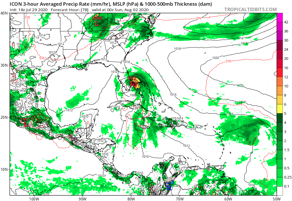
18Z ICON hour 63 is 5MB stronger than the 12Z run and shows a 997MB storm near Andros moving slowly NW.
0 likes

Re: ATL: NINE - Models
Models coming into rough consensus of a track somewhere off the east coast. How many times has this happened in the past? Too many times to count. For whatever reason, storms more times than not recurve east of the peninsula. Things can change of course in the next few days. But if it does stay off the east coast of FL, seems like the GFS-para would have done the best with sniffing this out early. Time will tell...
1 likes
Re: ATL: NINE - Models
12z EPS is trending towards a deeper trough over the MS rive valley to erode the western end of the narrow ridge to its north when it gets close to FL, but at the same time it keeps trending towards the Bermuda ridge expanding northward to block PTC9 from going OTS.


1 likes
-
gatorcane
- S2K Supporter
- Posts: 23708
- Age: 48
- Joined: Sun Mar 13, 2005 3:54 pm
- Location: Boca Raton, FL
Re: ATL: NINE - Models
gatorcane wrote:18Z ICON hour 63 is 5MB stronger than the 12Z run and shows a 997MB storm near Andros moving slowly NW.
0 likes

Re: ATL: NINE - Models
NDG wrote:12z EPS is trending towards a deeper trough over the MS rive valley to erode the western end of the narrow ridge to its north when it gets close to FL, but at the same time it keeps trending towards the Bermuda ridge expanding northward to block PTC9 from going OTS.
https://i.imgur.com/o4CcoR1.gif
https://i.imgur.com/7JrvTnW.gif
Meaning ?? It’s gets trapped from going out to sea and forced inland somewhere along the eastern seaboard?
0 likes
-
HurricaneFrances04
- Category 2

- Posts: 597
- Joined: Mon Jun 25, 2012 8:09 am
- Location: Fort Lauderdale, Florida
Re: ATL: NINE - Models
NDG wrote:12z EPS is trending towards a deeper trough over the MS rive valley to erode the western end of the narrow ridge to its north when it gets close to FL, but at the same time it keeps trending towards the Bermuda ridge expanding northward to block PTC9 from going OTS.
https://i.imgur.com/o4CcoR1.gif
https://i.imgur.com/7JrvTnW.gif
Didn't the GFS show something similar to that a few days ago when it showed a track into NE Florida.
0 likes
-
AutoPenalti
- Category 5
- Posts: 4091
- Age: 29
- Joined: Mon Aug 17, 2015 4:16 pm
- Location: Ft. Lauderdale, Florida
Re: ATL: NINE - Models
NDG wrote:12z EPS is trending towards a deeper trough over the MS rive valley to erode the western end of the narrow ridge to its north when it gets close to FL, but at the same time it keeps trending towards the Bermuda ridge expanding northward to block PTC9 from going OTS.
https://i.imgur.com/o4CcoR1.gif
https://i.imgur.com/7JrvTnW.gif
Wowzers, that trough is unusual for August.
0 likes
The posts in this forum are NOT official forecasts and should not be used as such. They are just the opinion of the poster and may or may not be backed by sound meteorological data. They are NOT endorsed by any professional institution or STORM2K. For official information, please refer to products from the NHC and NWS.
Model Runs Cheat Sheet:
GFS (5:30 AM/PM, 11:30 AM/PM)
HWRF, GFDL, UKMET, NAVGEM (6:30-8:00 AM/PM, 12:30-2:00 AM/PM)
ECMWF (1:45 AM/PM)
TCVN is a weighted averaged
-
gatorcane
- S2K Supporter
- Posts: 23708
- Age: 48
- Joined: Sun Mar 13, 2005 3:54 pm
- Location: Boca Raton, FL
Re: ATL: NINE - Models
ICON shows some good intensification now as it goes over the Gulfstream heading into SE Florida. Between 69 and 81 hours it drops 7MB. This is a change from prior runs which showed weakening on the approach:
Last edited by gatorcane on Wed Jul 29, 2020 4:20 pm, edited 1 time in total.
1 likes
Who is online
Users browsing this forum: No registered users and 59 guests