ATL: ISAIAS - Post-Tropical - Discussion
Moderator: S2k Moderators
-
MGC

- S2K Supporter

- Posts: 5940
- Joined: Sun Mar 23, 2003 9:05 pm
- Location: Pass Christian MS, or what is left.
Re: ATL: NINE - Potential Tropical Cyclone - Discussion
Where's the beef or in this case west wind? Wicked Witch of the West not giving it up yet. Can't remember how many rotating strong tropical waves I've witnessed over the years that look like a TS with no west wind at the surface. PTC9 is still moving too briskly to close off. Likely will when it slows down. The longer that takes to happen the further west it will go IMO. I'm just hoping it has a date with Hispaniola and gets shredded....MGC
1 likes

Re: ATL: NINE - Potential Tropical Cyclone - Discussion
Visioen wrote:At this point my best guess for a track would be to close my eyes and draw a line.
Which is exactly what I did:
https://i.imgur.com/mT85lKg.png
I agree, the Euro has been persistent in the vorticity reforming near the northern coast of Cuba.
0 likes
-
Aric Dunn
- Category 5

- Posts: 21238
- Age: 43
- Joined: Sun Sep 19, 2004 9:58 pm
- Location: Ready for the Chase.
- Contact:
Re: ATL: NINE - Potential Tropical Cyclone - Discussion
Essentially the only way this gets north of the islands is if a reformation happens.
3 likes
Note: If I make a post that is brief. Please refer back to previous posts for the analysis or reasoning. I do not re-write/qoute what my initial post said each time.
If there is nothing before... then just ask
Space & Atmospheric Physicist, Embry-Riddle Aeronautical University,
I believe the sky is falling...
If there is nothing before... then just ask
Space & Atmospheric Physicist, Embry-Riddle Aeronautical University,
I believe the sky is falling...

Re: ATL: NINE - Potential Tropical Cyclone - Discussion
panamatropicwatch wrote:HH climbing, think they are headed home.
They're climbing out.
Still an open wave.
1 likes
-
EquusStorm
- Category 5
- Posts: 1649
- Age: 35
- Joined: Thu Nov 07, 2013 1:04 pm
- Location: Jasper, AL
- Contact:
Re: ATL: NINE - Potential Tropical Cyclone - Discussion
Definitely the most impressive PTC/wave I've ever seen this morning! Hard to get a fully stacked and closed LLC while moving really quickly but if it doesn't slow down and close off soon I'll be very shocked.
Imagine before the PTC designation was introduced, this being tracked as a 90/90 wave until a closed LLC was confirmed and the mass raging at the lack of any classification lol
Imagine before the PTC designation was introduced, this being tracked as a 90/90 wave until a closed LLC was confirmed and the mass raging at the lack of any classification lol
0 likes
Colors of lost purpose on the canvas of irrelevance
Not a meteorologist, in fact more of an idiot than anything. You should probably check with the NHC or a local NWS office for official information.
Not a meteorologist, in fact more of an idiot than anything. You should probably check with the NHC or a local NWS office for official information.
-
nativefloridian

- Tropical Storm

- Posts: 172
- Joined: Tue Aug 21, 2012 2:48 pm
- Location: Pembroke Pines, FL
Re: ATL: NINE - Potential Tropical Cyclone - Discussion
https://rammb-slider.cira.colostate.edu ... 480&y=7582
To my untrained eye, the area just west of Dominica appears to be a center of circulation...IMO
To my untrained eye, the area just west of Dominica appears to be a center of circulation...IMO
Last edited by nativefloridian on Wed Jul 29, 2020 9:33 am, edited 1 time in total.
0 likes
-
SFLcane

- S2K Supporter
- Posts: 10281
- Age: 48
- Joined: Sat Jun 05, 2010 1:44 pm
- Location: Lake Worth Florida
Re: ATL: NINE - Potential Tropical Cyclone - Discussion
Aric Dunn wrote:Essentially the only way this gets north of the islands is if a reformation happens.
Then it’s game over. I would say
1 likes

Re: ATL: NINE - Potential Tropical Cyclone - Discussion
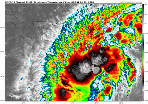
 OMG?? Who poked the tiger?!! Just woke up to the visible satellite and this thing is finally doing it's thing. Establishing a CDO, explosive outflow, and the broad circulation becoming much less elliptical. I'll admit that I thought this was going to need an additional 12-24 hr.'s to really coalesce but it's starting to happen now. It may or may not have a defined COC yet but just like a Spring-time two mile wide tube dropping to the ground in the Central Plains, this is REALLY REALLY taking on a very ominous look for the first time. I have repeated ad nauseam that this might well wait until entering "the graveyard" and then start going nuts. Well, pass the planters peanuts cuz there'll be plenty to go around. In this classic strong easterly surge pattern, the LLC typically lags behind (or east) of center and/or should be tilted east to west in terms of aligning with the MLC. If the convective pattern continues, we should soon begin to see some better indication of banding start to occur in the right semi-circle just east or a bit southeast of the convection. That is unless of course a COC begins to pop smack within the CDO. Appears to me to be tracking about 280. Anyone up for a cruise through the Windward Passage?
6 likes
Andy D
(For official information, please refer to the NHC and NWS products.)
(For official information, please refer to the NHC and NWS products.)
Re: ATL: NINE - Potential Tropical Cyclone - Discussion
I think you can pretty much scratch FL off the list.
Start thinking more about the West Carib / GoM
Start thinking more about the West Carib / GoM
1 likes
-
jaxfladude
- Category 5
- Posts: 1249
- Joined: Wed Aug 24, 2005 9:36 pm
- Location: Jacksonville, Fla
Re: ATL: NINE - Potential Tropical Cyclone - Discussion
Welp that track I saw on a local Jacksonville Florida news station sure was a flashback to Irma but much much much weaker than she was....fingers crossed
Last edited by jaxfladude on Wed Jul 29, 2020 9:29 am, edited 1 time in total.
0 likes
Stay safe y'all
Re: ATL: NINE - Potential Tropical Cyclone - Discussion
This track is similar (just west) of 2006's Ernesto (Which defied the models by continuing to push west), but good luck going through the old topics on it as back then there was a 25 page limit. 9 seems to be following the general climatological rule of thumb, weaker typically goes west.
Last edited by BobHarlem on Wed Jul 29, 2020 9:37 am, edited 1 time in total.
0 likes

Re: ATL: NINE - Potential Tropical Cyclone - Discussion
This is starting to look more and more organized to me. Almost as if its saying - "Do i have everyone's attention now?!"
6 likes
-
AutoPenalti
- Category 5
- Posts: 4091
- Age: 29
- Joined: Mon Aug 17, 2015 4:16 pm
- Location: Ft. Lauderdale, Florida
Re: ATL: NINE - Potential Tropical Cyclone - Discussion
This needs to pull up FAST if it's going to survive.
0 likes
The posts in this forum are NOT official forecasts and should not be used as such. They are just the opinion of the poster and may or may not be backed by sound meteorological data. They are NOT endorsed by any professional institution or STORM2K. For official information, please refer to products from the NHC and NWS.
Model Runs Cheat Sheet:
GFS (5:30 AM/PM, 11:30 AM/PM)
HWRF, GFDL, UKMET, NAVGEM (6:30-8:00 AM/PM, 12:30-2:00 AM/PM)
ECMWF (1:45 AM/PM)
TCVN is a weighted averaged
Re: ATL: NINE - Potential Tropical Cyclone - Discussion
[quote="ScottNAtlanta"]This is the track I am thinking
I can see that one out my front door!
I can see that one out my front door!
1 likes
-
Evil Jeremy

- S2K Supporter
- Posts: 5463
- Age: 32
- Joined: Mon Apr 10, 2006 2:10 pm
- Location: Los Angeles, CA
Re: ATL: NINE - Potential Tropical Cyclone - Discussion
Can't recall the last time I've seen so much disagreement for a non-cyclone. It's heading west. It's clearly going WNW. Convection is bouncing NW. It's an open wave. It's about to close off. North of Hispaniola. South of Hispaniola. Shear and dry air will kill it North of the islands. The heat content is ripe for intensification. Florida can take a nap now. Florida's got to keep it's eyes open.
Man, I can only imagine what the NHC has been debating internally for the past week. I'm still in awe at Stewart's excellent discussion from last night. I can only wonder what Avila's rebuttal would have been...
I think we can all agree that we are lucky this system's gargantuan footprint and fast pace across the Atlantic prevented what could have been a much worse situation for the NE Caribbean today.
13 likes
Frances 04 / Jeanne 04 / Katrina 05 / Wilma 05 / Fay 08 / Debby 12 / Andrea 13 / Colin 16 / Hermine 16 / Matthew 16 / Irma 17
-
tropicwatch

- Category 5
- Posts: 3426
- Age: 62
- Joined: Sat Jun 02, 2007 10:01 am
- Location: Panama City Florida
- Contact:
Re: ATL: NINE - Potential Tropical Cyclone - Discussion
GCANE wrote:I think you can pretty much scratch FL off the list.
Start thinking more about the West Carib / GoM
Florida does have a coastline along the Gulf of Mexico ya know
9 likes
Tropicwatch
Agnes 72', Eloise 75, Elena 85', Kate 85', Charley 86', Florence 88', Beryl 94', Dean 95', Erin 95', Opal 95', Earl 98', Georges 98', Ivan 2004', Arlene 2005', Dennis 2005', Ida 2009' Debby 2012' Irma 2017' Michael 2018'
Agnes 72', Eloise 75, Elena 85', Kate 85', Charley 86', Florence 88', Beryl 94', Dean 95', Erin 95', Opal 95', Earl 98', Georges 98', Ivan 2004', Arlene 2005', Dennis 2005', Ida 2009' Debby 2012' Irma 2017' Michael 2018'


Re: ATL: NINE - Potential Tropical Cyclone - Discussion
b0tzy29 wrote:https://media.giphy.com/media/J1GUQl58tAUx0fACPw/giphy.gif
This is starting to look more and more organized to me. Almost as if its saying - "Do i have everyone's attention now?!"
Looks like it is tripping over SA on it's journey from a horizontally tilted wave axis to a vertically tilted, more stacked one
1 likes
-
HurricaneFrances04
- Category 2

- Posts: 597
- Joined: Mon Jun 25, 2012 8:09 am
- Location: Fort Lauderdale, Florida
Re: ATL: NINE - Potential Tropical Cyclone - Discussion
Eric Blake seemed to disagree with Stewart this morning:
The cyclone will probably take some time to recover after
moving over the very high mountains of Hispaniola, and some of the
guidance after that time shows an increase in southwesterly shear
over the Straits of Florida that could limit the potential of the
cyclone. Simply put, there are a lot of hurdles in the system's
way, so it is best to stay on the conservative side at the moment
and continue to stress the large uncertainty after it leaves the
Caribbean. Little change was made to the forecast intensity,
although the guidance has come down at longer range for many of the
models.
1 likes
-
ScottNAtlanta

- Category 5
- Posts: 2535
- Joined: Sat May 25, 2013 3:11 pm
- Location: Atlanta, GA
Re: ATL: NINE - Potential Tropical Cyclone - Discussion
Evil Jeremy wrote: I can only wonder what Avila's rebuttal would have been...
I think we can all agree that we are lucky this system's gargantuan footprint and fast pace across the Atlantic prevented what could have been a much worse situation for the NE Caribbean today.
Avila's rebuttal would have been short. Point made...done. He was never one for excess verbiage.
Last edited by ScottNAtlanta on Wed Jul 29, 2020 9:37 am, edited 1 time in total.
3 likes
The posts in this forum are NOT official forecast and should not be used as such. They are just the opinion of the poster and may or may not be backed by sound meteorological data. They are NOT endorsed by any professional institution or storm2k.org. For official information, please refer to the NHC and NWS products.
-
Dean4Storms
- S2K Supporter
- Posts: 6358
- Age: 63
- Joined: Sun Aug 31, 2003 1:01 pm
- Location: Miramar Bch. FL
Re: ATL: NINE - Potential Tropical Cyclone - Discussion
Much closer, maybe this afternoon. Think it has a shot of riding on the South edge of Hispaniola.
4 likes
Who is online
Users browsing this forum: No registered users and 10 guests