ATL: LAURA - Models

Moderator: S2k Moderators

Message
Author
User avatar
gatorcane
S2K Supporter
S2K Supporter
Posts: 23691
Age: 47
Joined: Sun Mar 13, 2005 3:54 pm
Location: Boca Raton, FL

Re: ATL: THIRTEEN - Models

#1341 Postby gatorcane » Thu Aug 20, 2020 1:24 pm

No development on the Euro, just a broad low / wave passing through:

Image

Image
Last edited by gatorcane on Thu Aug 20, 2020 1:26 pm, edited 1 time in total.
0 likes   

Shell Mound
Category 5
Category 5
Posts: 2434
Age: 32
Joined: Thu Sep 07, 2017 3:39 pm
Location: St. Petersburg, FL → Scandinavia

Re: ATL: THIRTEEN - Models

#1342 Postby Shell Mound » Thu Aug 20, 2020 1:25 pm

SouthFLTropics wrote:
Aric Dunn wrote:
SouthFLTropics wrote:
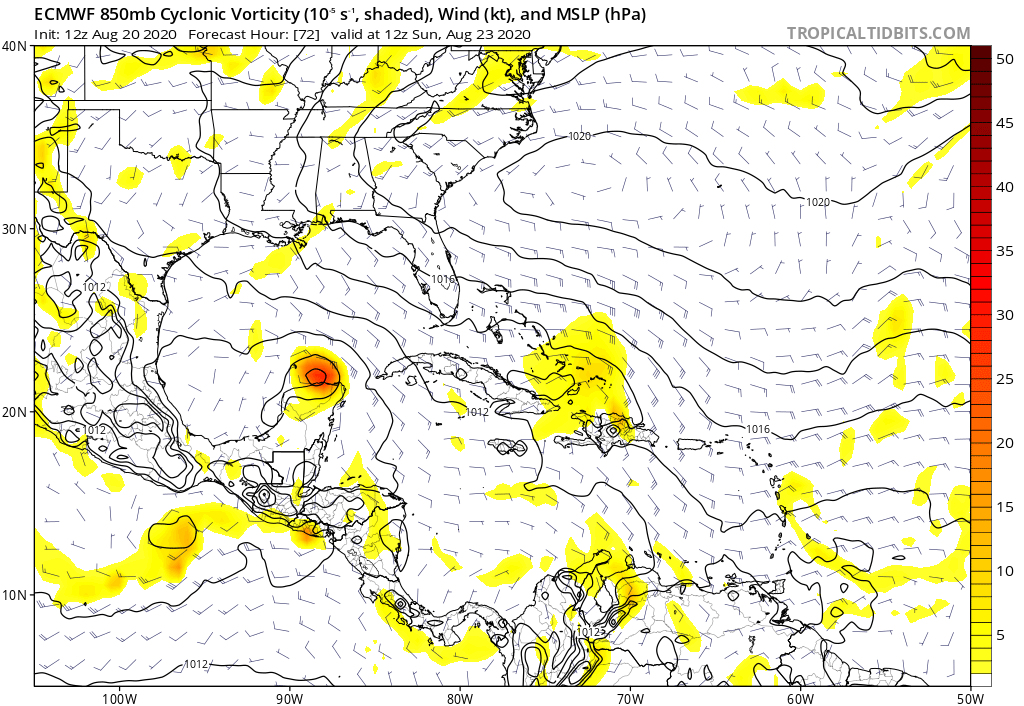
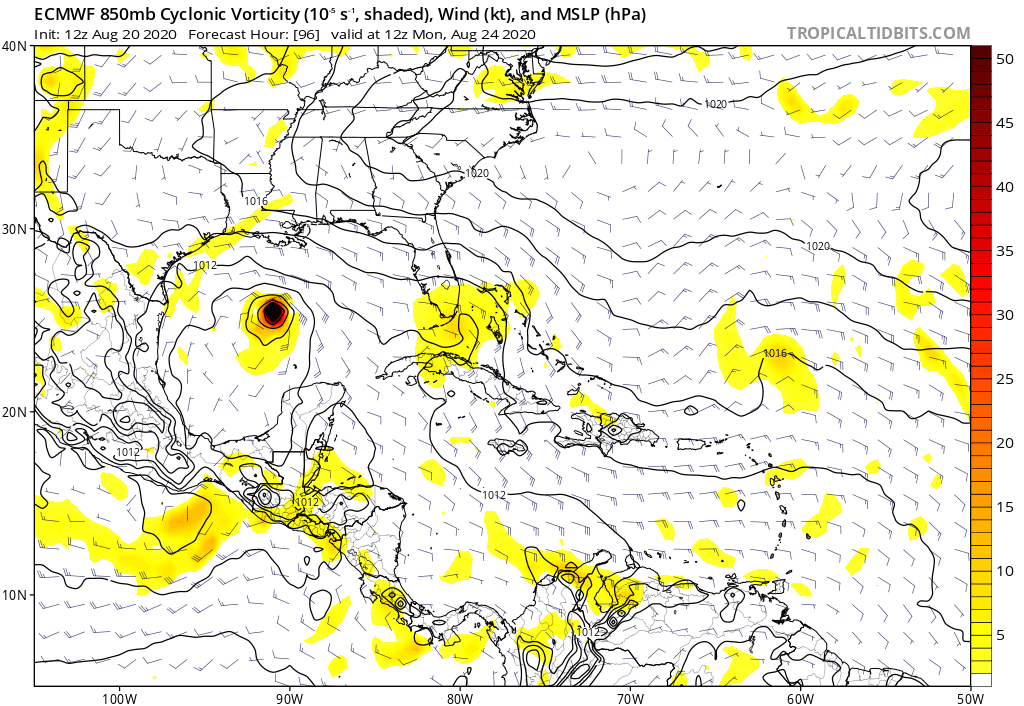
Very important to note what the Euro DOES DO. It spins TD 14 up in the GOM pretty significantly. One will thrive, the other one won't.


That logic would hold if the was showing td 13 stronger on previous runs..

because before this it was not developing either of them lol


This is also true... In the end though, I don't think they can both coexist within the same region without somehow affecting one another.

I really hope 2020 doesn’t take this as a challenge.
11 likes   
CVW / MiamiensisWx / Shell Mound
The posts in this forum are NOT official forecasts and should not be used as such. They are just the opinion of the poster and may or may not be backed by sound meteorological data. They are NOT endorsed by any professional institution or STORM2K. For official information, please refer to products from the NHC and NWS.

User avatar
Blinhart
Category 5
Category 5
Posts: 2081
Age: 48
Joined: Thu Sep 08, 2011 3:13 pm
Location: Crowley, La.

Re: ATL: THIRTEEN - Models

#1343 Postby Blinhart » Thu Aug 20, 2020 1:26 pm

cp79 wrote:
SouthFLTropics wrote:
Hypercane_Kyle wrote:There's a very good reason why two hurricanes have never been recorded in the Gulf of Mexico at the same time. If 13L gets a lot stronger than anticipated, 14L will remain weaker due to the former's outflow. This is what the HWRF is showing. Conversely, the opposite could occur, where 14L ramps up more than expected and becomes a hurricane in the Gulf, weakening 13L as it enters the Gulf. Very strange situation for sure.


This is correct. Without going in depth, it's Physics 101. No two objects occupying the same space, for every action in nature there is an equal and opposite reaction, etc.


A lot will depend on land interaction with 14. It could be in the Yucatán for a while. That would inhibit it’s development. It’s going to be interesting to see how this plays out and it’s why I think the models are having such a hard time right now.


I think it actually depends on which part of the Yucatan it goes over, some parts of the Peninsula won't have much effect on it, but yeah the time over will have some effect on it.
0 likes   
Personal Forecast Disclaimer:
The posts in this forum are NOT official forecast and should not be used as such. They are just the opinion of the poster and may or may not be backed by sound meteorological data. They are NOT endorsed by any professional institution or storm2k.org. For official information, please refer to the NHC and NWS products.

User avatar
chris_fit
Category 5
Category 5
Posts: 3222
Age: 42
Joined: Wed Sep 10, 2003 11:58 pm
Location: Tampa Bay Area, FL

Re: ATL: THIRTEEN - Models

#1344 Postby chris_fit » Thu Aug 20, 2020 1:26 pm

12 GFS Ens - Semi keep 13 around ---- check out the 'reinforcement' towards the end of that clip...

Image
3 likes   

User avatar
Blinhart
Category 5
Category 5
Posts: 2081
Age: 48
Joined: Thu Sep 08, 2011 3:13 pm
Location: Crowley, La.

Re: ATL: THIRTEEN - Models

#1345 Postby Blinhart » Thu Aug 20, 2020 1:27 pm

Shell Mound wrote:
SouthFLTropics wrote:
Aric Dunn wrote:
That logic would hold if the was showing td 13 stronger on previous runs..

because before this it was not developing either of them lol


This is also true... In the end though, I don't think they can both coexist within the same region without somehow affecting one another.

I really hope 2020 doesn’t take this as a challenge.


I don't there is no reason for 2 established systems to be in the GoM at the same time, just depends on the way their Atmospheric Bubble is.
0 likes   
Personal Forecast Disclaimer:
The posts in this forum are NOT official forecast and should not be used as such. They are just the opinion of the poster and may or may not be backed by sound meteorological data. They are NOT endorsed by any professional institution or storm2k.org. For official information, please refer to the NHC and NWS products.

User avatar
Beef Stew
Category 1
Category 1
Posts: 498
Joined: Sat May 30, 2020 11:31 am
Location: South Florida

Re: ATL: THIRTEEN - Models

#1346 Postby Beef Stew » Thu Aug 20, 2020 1:28 pm

Image

For anyone doubting how fast a system can get its act together and bomb out over the Bahamas/Florida straits (like the 12z HWRF is suggesting as a possible solution), the Labor Day Storm of 1935 is a solemn reminder. While this is the most extreme example of RI here, it is still a historical precedent. Now the setup is different, and I'm in no way saying that 13 will rival the Labor Day Hurricane in track or intensity. It just goes to show that 13 may not need much time to become a monster should everything fall into place.
6 likes   

User avatar
toad strangler
S2K Supporter
S2K Supporter
Posts: 4543
Joined: Sun Jul 28, 2013 3:09 pm
Location: Earth
Contact:

Re: ATL: THIRTEEN - Models

#1347 Postby toad strangler » Thu Aug 20, 2020 1:29 pm

It is hard to ignore such a steadfast (on 13) Euro.
0 likes   

User avatar
Ivanhater
Storm2k Moderator
Storm2k Moderator
Posts: 11162
Age: 38
Joined: Fri Jul 01, 2005 8:25 am
Location: Pensacola

Re: ATL: THIRTEEN - Models

#1348 Postby Ivanhater » Thu Aug 20, 2020 1:30 pm

Looks like some strengthening as it approaches the Al FL border
0 likes   
Michael

Shell Mound
Category 5
Category 5
Posts: 2434
Age: 32
Joined: Thu Sep 07, 2017 3:39 pm
Location: St. Petersburg, FL → Scandinavia

Re: ATL: THIRTEEN - Models

#1349 Postby Shell Mound » Thu Aug 20, 2020 1:32 pm

toad strangler wrote:It is hard to ignore such a steadfast (on 13) Euro.

It would really be something to see simultaneous hurricanes threatening Houston/Galveston and Miami/Tampa/New Orleans. But it’s 2020...
0 likes   
CVW / MiamiensisWx / Shell Mound
The posts in this forum are NOT official forecasts and should not be used as such. They are just the opinion of the poster and may or may not be backed by sound meteorological data. They are NOT endorsed by any professional institution or STORM2K. For official information, please refer to products from the NHC and NWS.

User avatar
Blown Away
S2K Supporter
S2K Supporter
Posts: 10147
Joined: Wed May 26, 2004 6:17 am

Re: ATL: THIRTEEN - Models

#1350 Postby Blown Away » Thu Aug 20, 2020 1:33 pm

If I had to make a forecast, I’m putting much more stock, not all in, in the Euro vs all the other models.
0 likes   
Hurricane Eye Experience: David 79, Irene 99, Frances 04, Jeanne 04, Wilma 05... EYE COMING MY WAY IN 2024…
Hurricane Brush Experience: Andrew 92, Erin 95, Floyd 99, Matthew 16, Irma 17, Ian 22, Nicole 22…

User avatar
aspen
Category 5
Category 5
Posts: 8818
Joined: Sat Oct 12, 2019 7:10 pm
Location: Connecticut, USA

Re: ATL: THIRTEEN - Models

#1351 Postby aspen » Thu Aug 20, 2020 1:34 pm

chris_fit wrote:12 GFS Ens - Semi keep 13 around ---- check out the 'reinforcement' towards the end of that clip...

https://i.imgur.com/iwMyXuA.gif

Oh wow, the Euro still really likes the 20/40 AEW. Off topic, but I’m surprised it hasn’t been given higher odds or designed as 99L, especially since some models show development within 3 days.
0 likes   
Irene '11 Sandy '12 Hermine '16 5/15/2018 Derecho Fay '20 Isaias '20 Elsa '21 Henri '21 Ida '21

I am only a meteorology enthusiast who knows a decent amount about tropical cyclones. Look to the professional mets, the NHC, or your local weather office for the best information.

User avatar
eastcoastFL
Category 5
Category 5
Posts: 3901
Age: 43
Joined: Thu Apr 12, 2007 12:29 pm
Location: Palm City, FL

Re: ATL: THIRTEEN - Models

#1352 Postby eastcoastFL » Thu Aug 20, 2020 1:36 pm

Blown Away wrote:If I had to make a forecast, I’m putting much more stock, not all in, in the Euro vs all the other models.


I’m in the opposite camp. Nhc had to make a forecast and they have a hurricane heading into the keys not a wave
8 likes   
Personal Forecast Disclaimer:
The posts in this forum are NOT official forecast and should not be used as such. They are just the opinion of the poster and may or may not be backed by sound meteorological data. They are NOT endorsed by any professional institution or storm2k.org. For official information, please refer to the NHC and NWS products.

AxaltaRacing24
Category 5
Category 5
Posts: 1753
Age: 25
Joined: Wed Jul 27, 2016 11:14 am
Location: Jupiter, FL

Re: ATL: THIRTEEN - Models

#1353 Postby AxaltaRacing24 » Thu Aug 20, 2020 1:37 pm

eastcoastFL wrote:
Blown Away wrote:If I had to make a forecast, I’m putting much more stock, not all in, in the Euro vs all the other models.


I’m in the opposite camp.

yep. the euro is playing catch up more than anything. every run has tried to dissipate the wave, then it developed into a TD.
4 likes   

User avatar
chris_fit
Category 5
Category 5
Posts: 3222
Age: 42
Joined: Wed Sep 10, 2003 11:58 pm
Location: Tampa Bay Area, FL

Re: ATL: THIRTEEN - Models

#1354 Postby chris_fit » Thu Aug 20, 2020 1:40 pm

AxaltaRacing24 wrote:
eastcoastFL wrote:
Blown Away wrote:If I had to make a forecast, I’m putting much more stock, not all in, in the Euro vs all the other models.


I’m in the opposite camp.

yep. the euro is playing catch up more than anything. every run has tried to dissipate the wave, then it developed into a TD.


To be fair, 13 looks like a wave right now.
0 likes   

User avatar
chris_fit
Category 5
Category 5
Posts: 3222
Age: 42
Joined: Wed Sep 10, 2003 11:58 pm
Location: Tampa Bay Area, FL

Re: ATL: THIRTEEN - Models

#1355 Postby chris_fit » Thu Aug 20, 2020 1:41 pm

Another pic of 12Z GFS Ens

Image
0 likes   

Shell Mound
Category 5
Category 5
Posts: 2434
Age: 32
Joined: Thu Sep 07, 2017 3:39 pm
Location: St. Petersburg, FL → Scandinavia

Re: ATL: THIRTEEN - Models

#1356 Postby Shell Mound » Thu Aug 20, 2020 1:42 pm

0 likes   
CVW / MiamiensisWx / Shell Mound
The posts in this forum are NOT official forecasts and should not be used as such. They are just the opinion of the poster and may or may not be backed by sound meteorological data. They are NOT endorsed by any professional institution or STORM2K. For official information, please refer to products from the NHC and NWS.

fox13weather
Professional-Met
Professional-Met
Posts: 161
Joined: Tue Sep 20, 2005 7:49 pm

Re: ATL: THIRTEEN - Models

#1357 Postby fox13weather » Thu Aug 20, 2020 1:45 pm

No model is wrong until proven wrong. At some point the ECMWF will have to fall in line with the more aggressive models. If it doesn't soon, it may end up being right all along.
12 likes   

User avatar
ConvergenceZone
Category 5
Category 5
Posts: 5194
Joined: Fri Jul 29, 2005 1:40 am
Location: Northern California

Re: ATL: THIRTEEN - Models

#1358 Postby ConvergenceZone » Thu Aug 20, 2020 1:45 pm

chris_fit wrote:
AxaltaRacing24 wrote:
eastcoastFL wrote:
I’m in the opposite camp.

yep. the euro is playing catch up more than anything. every run has tried to dissipate the wave, then it developed into a TD.


To be fair, 13 looks like a wave right now.


I wonder if the NHC would downgrade it to a wave if they weren’t able to find a closed circulation or if they would maintain TD status for awhile?
0 likes   

Nuno
Category 2
Category 2
Posts: 597
Joined: Fri Aug 30, 2019 8:35 am
Location: Coral Gables, FL

Re: ATL: THIRTEEN - Models

#1359 Postby Nuno » Thu Aug 20, 2020 1:49 pm

ConvergenceZone wrote:
chris_fit wrote:
AxaltaRacing24 wrote:yep. the euro is playing catch up more than anything. every run has tried to dissipate the wave, then it developed into a TD.


To be fair, 13 looks like a wave right now.


I wonder if the NHC would downgrade it to a wave if they weren’t able to find a closed circulation or if they would maintain TD status for awhile?


Probably not since SFL is already on alert. Discontinuing advisories would make them seem unreliable or that the potential for this storm isn't there even if their language emphasizes that it exists. Same with why they'll keep it as a hurricane in the cone near FL unless it really falls apart.

Remember, this current state of TD13 was also predicted, it isn't going to light up likely until it clears the islands.
2 likes   
Andrew (1992), Irene (1999), Frances (2004), Katrina (2005), Wilma (2005), Fay (2008), Irma (2017), Eta (2020), Ian (2022)

psyclone
S2K Supporter
S2K Supporter
Posts: 4762
Joined: Wed Aug 24, 2005 9:04 pm
Location: palm harbor fl

Re: ATL: THIRTEEN - Models

#1360 Postby psyclone » Thu Aug 20, 2020 1:51 pm

fox13weather wrote:No model is wrong until proven wrong. At some point the ECMWF will have to fall in line with the more aggressive models. If it doesn't soon, it may end up being right all along.

Massive applause. As of now...it's fair to say it is winning.
0 likes   


Return to “2020”

Who is online

Users browsing this forum: No registered users and 8 guests