ATL: ISAIAS - Models

Moderator: S2k Moderators

Message
Author
User avatar
aspen
Category 5
Category 5
Posts: 8818
Joined: Sat Oct 12, 2019 7:10 pm
Location: Connecticut, USA

Re: ATL: NINE - Models

#1381 Postby aspen » Wed Jul 29, 2020 8:59 pm

b0tzy29 wrote:https://media.giphy.com/media/ZA4UxSct0xoCY7bJ0N/giphy.gif

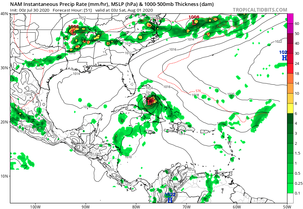
I can tell you with certainty that if this verifies - it will not be pretty on the Jersey Coast or Long Island

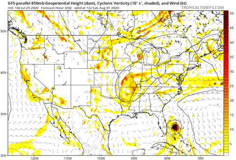
Oh look at that second TC forming in about 5 days. Maybe the GFS-Para is hinting the wave in the central MDR could try and develop.
2 likes   
Irene '11 Sandy '12 Hermine '16 5/15/2018 Derecho Fay '20 Isaias '20 Elsa '21 Henri '21 Ida '21

I am only a meteorology enthusiast who knows a decent amount about tropical cyclones. Look to the professional mets, the NHC, or your local weather office for the best information.

User avatar
ColdMiser123
Professional-Met
Professional-Met
Posts: 904
Age: 29
Joined: Mon Sep 26, 2016 3:26 pm
Location: Northeast US

Re: ATL: NINE - Models

#1382 Postby ColdMiser123 » Wed Jul 29, 2020 9:02 pm

DestinHurricane wrote:
ColdMiser123 wrote:18z EPS even more enthused with PTC 9. I'd say over half now show a sub 1000 mb system. Quite a few hurricane landfalls all across the east coast.


How are they strengthening the system in the short term? are they initializing it and immediately strengthening or are they it strengthening after it is north of the GAs?


TheStormExpert wrote:
ColdMiser123 wrote:18z EPS even more enthused with PTC 9. I'd say over half now show a sub 1000 mb system. Quite a few hurricane landfalls all across the east coast.

Can you post a picture please?


 https://twitter.com/PeeDee_WxSC/status/1288647790004969472


0 likes   
B.S., M.S., Meteorology & Atmospheric Science

User avatar
gatorcane
S2K Supporter
S2K Supporter
Posts: 23691
Age: 47
Joined: Sun Mar 13, 2005 3:54 pm
Location: Boca Raton, FL

Re: ATL: NINE - Models

#1383 Postby gatorcane » Wed Jul 29, 2020 9:07 pm

:uarrow: Quite a number landfall in SE Florida or skim the coast with one 960-979mb landfall
1 likes   

User avatar
gatorcane
S2K Supporter
S2K Supporter
Posts: 23691
Age: 47
Joined: Sun Mar 13, 2005 3:54 pm
Location: Boca Raton, FL

Re: ATL: NINE - Models

#1384 Postby gatorcane » Wed Jul 29, 2020 9:22 pm

00Z NAM much stronger and right shift through 51 hours, heading WNW:

Image
2 likes   

User avatar
gatorcane
S2K Supporter
S2K Supporter
Posts: 23691
Age: 47
Joined: Sun Mar 13, 2005 3:54 pm
Location: Boca Raton, FL

Re: ATL: NINE - Models

#1385 Postby gatorcane » Wed Jul 29, 2020 9:33 pm

Turning north at 63 hours:

Image
0 likes   

User avatar
DestinHurricane
Category 4
Category 4
Posts: 935
Joined: Tue May 01, 2018 8:05 am
Location: New York, NY

Re: ATL: NINE - Models

#1386 Postby DestinHurricane » Wed Jul 29, 2020 9:39 pm

Are the models sniffing out more favorable conditions near S FL and the Bahamas this weekend?
0 likes   
Michael 2018

User avatar
GeneratorPower
S2K Supporter
S2K Supporter
Posts: 1648
Age: 45
Joined: Sun Dec 18, 2005 11:48 pm
Location: Huntsville, AL

Re: ATL: ISAIAS - Models

#1387 Postby GeneratorPower » Wed Jul 29, 2020 10:10 pm

None of the model runs I’ve seen today show much cause for concern for wind or surge in Florida even with a direct hit. Nuisance impacts such as overturned plastic lawn chairs looks like about it.
1 likes   

Hurricane Mike
Category 2
Category 2
Posts: 644
Joined: Tue Apr 10, 2018 7:44 am

Re: ATL: ISAIAS - Models

#1388 Postby Hurricane Mike » Wed Jul 29, 2020 10:29 pm

GeneratorPower wrote:None of the model runs I’ve seen today show much cause for concern for wind or surge in Florida even with a direct hit. Nuisance impacts such as overturned plastic lawn chairs looks like about it.


Heavy rain and beach erosion at the very least.
0 likes   

User avatar
aspen
Category 5
Category 5
Posts: 8818
Joined: Sat Oct 12, 2019 7:10 pm
Location: Connecticut, USA

Re: ATL: ISAIAS - Models

#1389 Postby aspen » Wed Jul 29, 2020 10:31 pm

I can’t wait for the models to shift all the way to the west again. Now that Isaias has formed with a defined center, and it’s still heading W/WNW, I doubt the models will favor this East Coast Sweep scenario for long.

And then they’re going to switch to the East later tomorrow.
2 likes   
Irene '11 Sandy '12 Hermine '16 5/15/2018 Derecho Fay '20 Isaias '20 Elsa '21 Henri '21 Ida '21

I am only a meteorology enthusiast who knows a decent amount about tropical cyclones. Look to the professional mets, the NHC, or your local weather office for the best information.

AutoPenalti
Category 5
Category 5
Posts: 4030
Age: 29
Joined: Mon Aug 17, 2015 4:16 pm
Location: Ft. Lauderdale, Florida

Re: ATL: ISAIAS - Models

#1390 Postby AutoPenalti » Wed Jul 29, 2020 10:33 pm

Watch models shift west now that there’s a CoC lol
0 likes   
The posts in this forum are NOT official forecasts and should not be used as such. They are just the opinion of the poster and may or may not be backed by sound meteorological data. They are NOT endorsed by any professional institution or STORM2K. For official information, please refer to products from the NHC and NWS.


Model Runs Cheat Sheet:
GFS (5:30 AM/PM, 11:30 AM/PM)
HWRF, GFDL, UKMET, NAVGEM (6:30-8:00 AM/PM, 12:30-2:00 AM/PM)
ECMWF (1:45 AM/PM)

TCVN
is a weighted averaged

User avatar
Blown Away
S2K Supporter
S2K Supporter
Posts: 10147
Joined: Wed May 26, 2004 6:17 am

Re: ATL: ISAIAS - Models

#1391 Postby Blown Away » Wed Jul 29, 2020 10:34 pm

I think the NHC just said the heck with it and follow the Euro.
0 likes   
Hurricane Eye Experience: David 79, Irene 99, Frances 04, Jeanne 04, Wilma 05... EYE COMING MY WAY IN 2024…
Hurricane Brush Experience: Andrew 92, Erin 95, Floyd 99, Matthew 16, Irma 17, Ian 22, Nicole 22…

User avatar
Evil Jeremy
S2K Supporter
S2K Supporter
Posts: 5463
Age: 32
Joined: Mon Apr 10, 2006 2:10 pm
Location: Los Angeles, CA

Re: ATL: ISAIAS - Models

#1392 Postby Evil Jeremy » Wed Jul 29, 2020 10:41 pm

00z GFS has some semblance of a circulation of Isaias in the Mona Passage in 12 hours, basically going entirely north of Hispaniola.

I.... doubt it.
0 likes   
Frances 04 / Jeanne 04 / Katrina 05 / Wilma 05 / Fay 08 / Debby 12 / Andrea 13 / Colin 16 / Hermine 16 / Matthew 16 / Irma 17

User avatar
Hurricaneman
Category 5
Category 5
Posts: 7351
Age: 45
Joined: Tue Aug 31, 2004 3:24 pm
Location: central florida

Re: ATL: ISAIAS - Models

#1393 Postby Hurricaneman » Wed Jul 29, 2020 10:47 pm

Evil Jeremy wrote:00z GFS has some semblance of a circulation of Isaias in the Mona Passage in 12 hours, basically going entirely north of Hispaniola.

I.... doubt it.


I think the GFS is out to lunch, it basically reforms north of Puerto Rico by morning which looking at satellites is very unlikely
0 likes   

HurricaneFrances04
Category 2
Category 2
Posts: 597
Joined: Mon Jun 25, 2012 8:09 am
Location: Fort Lauderdale, Florida

Re: ATL: ISAIAS - Models

#1394 Postby HurricaneFrances04 » Wed Jul 29, 2020 10:48 pm

GFS is stronger, but should easily miss Florida this run
0 likes   

caneseddy
Category 5
Category 5
Posts: 1172
Joined: Fri Sep 03, 2004 9:31 pm
Location: Plantation, FL

Re: ATL: ISAIAS - Models

#1395 Postby caneseddy » Wed Jul 29, 2020 10:50 pm

Evil Jeremy wrote:00z GFS has some semblance of a circulation of Isaias in the Mona Passage in 12 hours, basically going entirely north of Hispaniola.

I.... doubt it.


Also highly doubt the system at the rate is going and where it's located is going to miss Hispaniola to the east.
0 likes   

HurricaneFrances04
Category 2
Category 2
Posts: 597
Joined: Mon Jun 25, 2012 8:09 am
Location: Fort Lauderdale, Florida

Re: ATL: ISAIAS - Models

#1396 Postby HurricaneFrances04 » Wed Jul 29, 2020 10:51 pm

Agree with the doubt regarding this run of the GFS. Forecasted IR is nowhere close to reality

Image
1 likes   

TheStormExpert

Re: ATL: ISAIAS - Models

#1397 Postby TheStormExpert » Wed Jul 29, 2020 10:51 pm

aspen wrote:I can’t wait for the models to shift all the way to the west again. Now that Isaias has formed with a defined center, and it’s still heading W/WNW, I doubt the models will favor this East Coast Sweep scenario for long.

And then they’re going to switch to the East later tomorrow.

The fact that we’re getting such big model swings even just a few days out tells you that the models have a bad handle on things right now.
0 likes   

User avatar
SouthFLTropics
Category 5
Category 5
Posts: 4236
Age: 50
Joined: Thu Aug 14, 2003 8:04 am
Location: Port St. Lucie, Florida

Re: ATL: ISAIAS - Models

#1398 Postby SouthFLTropics » Wed Jul 29, 2020 10:52 pm

I'm guessing that the most recent data that led to the 11:00 PM upgrade was probably not fed into these 00z runs. We may not see much of a change in the models due to this until 06z. If that is the case you can throw this GFS run in the trash. :Can:
2 likes   
Fourth Generation Florida Native

Personal Storm History: David 79, Andrew 92, Erin 95, Floyd 99, Irene 99, Frances 04, Jeanne 04, Wilma 05, Matthew 16, Irma 17, Ian 22, Nicole 22, Milton 24

User avatar
STRiZZY
Category 1
Category 1
Posts: 276
Joined: Fri Aug 05, 2016 6:01 pm
Location: Largo, FL

Re: ATL: ISAIAS - Models

#1399 Postby STRiZZY » Wed Jul 29, 2020 10:52 pm

HurricaneFrances04 wrote:Agree with the doubt regarding this run of the GFS. Forecasted IR is nowhere close to reality

https://i.imgur.com/bJ0Juaq.png


Exactly lol, it needs to be flipped upside down.
0 likes   

HurricaneFrances04
Category 2
Category 2
Posts: 597
Joined: Mon Jun 25, 2012 8:09 am
Location: Fort Lauderdale, Florida

Re: ATL: ISAIAS - Models

#1400 Postby HurricaneFrances04 » Wed Jul 29, 2020 10:53 pm

The fake convection to the north is probably why the GFS has the center going north of Hispaniola

Image
0 likes   


Return to “2020”

Who is online

Users browsing this forum: No registered users and 5 guests