ATL: ETA - Models
Moderator: S2k Moderators

Re: ATL: ETA - Models
I think what some are missing on this board is just the prolonged nature of this event. No one is saying there will be major hurricane bearing down on Florida. But when ETA approaches SFL it will slow to crawl as it moves slowly north and then NW as it gradually merges with the midlevel low in the eastern GOM. At that point, essentially ETA will be cutoff from any major steering. You see that in some of the dynamic models like HWRF where once in the SE GOM the system does several near stationary loops. Since at that point ETA may be subtropical, expect all the heavy weather to the east continuously pounding the peninsula for several days.
8 likes

Re: ATL: ETA - Models
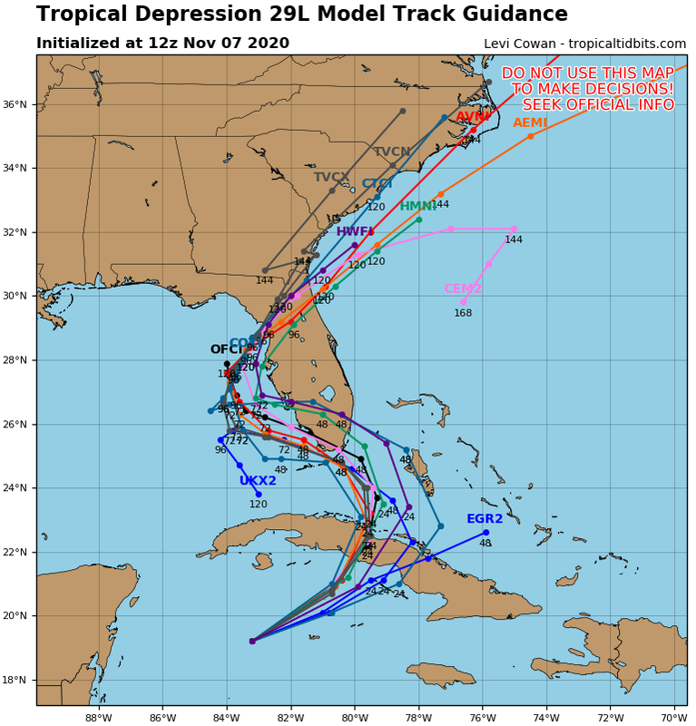
SFLcane wrote:12z models shift north again.
https://i.postimg.cc/nLm3667H/139053-D9-A591-4-AB6-B564-A20-F70-F61-A7-C.png
Throw the 12z models out the window, Eta was initialized way too far west and north of its current location according to surface conditions from The Cayman Islands.
0 likes
Re: ATL: ETA - Models
NDG wrote:SFLcane wrote:12z models shift north again.
https://i.postimg.cc/nLm3667H/139053-D9-A591-4-AB6-B564-A20-F70-F61-A7-C.png
Throw the 12z models out the window, Eta was initialized way too far west and north of its current location according to surface conditions from The Cayman Islands.
Not sure I'd say throw all of them out. The NHC alluded to a possible center reformation to the NE in their 5 am disc and indicated it wouldn't have much bearing on the overall track forecast.
1 likes

Re: ATL: ETA - Models
If Eta is south and east of the official track which would flatten out the track how does that affect the outcome when it’s up by Florida?
1 likes
-
Weatherboy1

- Category 5

- Posts: 1190
- Age: 50
- Joined: Mon Jul 05, 2004 1:50 pm
- Location: Jupiter/Sarasota, FL
Re: ATL: ETA - Models
boca wrote:If Eta is south and east of the official track which would flatten out the track how does that affect the outcome when it’s up by Florida?
If ETA starts the NW turn from a point further south and east I would expect the ultimate landfall point to be a bit further north on the FL peninsula. Not a ton as same general steering flow applies. But maybe FLL area vs. south of MIA as an example
0 likes
Re: ATL: ETA - Models
boca wrote:If Eta is south and east of the official track which would flatten out the track how does that affect the outcome when it’s up by Florida?
A track further south and east in the short term could mean a track closer over S FL, by looking at the Euro & GFS ensembles that showed members with the current further south and east track.
3 likes

Re: ATL: ETA - Models
Weatherboy1 wrote:boca wrote:If Eta is south and east of the official track which would flatten out the track how does that affect the outcome when it’s up by Florida?
If ETA starts the NW turn from a point further south and east I would expect the ultimate landfall point to be a bit further north on the FL peninsula. Not a ton as same general steering flow applies. But maybe FLL area vs. south of MIA as an example
Due to its structure, this may be a lopsided storm with the bulk of worst weather far NE of the “center” and minimal effects west and south.
This would put The Bahamas and East Coastal South Florida in the worst of it.
Thus the rainfall forecasts of 5-10” for East Coast and only 3-5” for the West coast even though the “center” will be closer to the West coast.(not seeing 15-20” like someone else posted, BTW)
Classic example of “don’t pay attention to where the center is” and also where the center is doesn’t get “hit” unlike most Hurricanes or Tropical Storms.
Similar to the many storms that have passed South Florida to the East where SE Fla gets spitting rain and gusty winds and The Bahamas get hammered.
I still don’t see a tremendous wind event but the rains on saturated grounds as the chief concern.
My $.02....
4 likes
Personal Forecast Disclaimer:
My posts are just my opinion and are most likely not backed by sound meteorological data. They are NOT endorsed by any professional institution or storm2k.org. For official information, please refer to the NHC and NWS products.
Bottom line is that I am just expressing my opinion!!!
My posts are just my opinion and are most likely not backed by sound meteorological data. They are NOT endorsed by any professional institution or storm2k.org. For official information, please refer to the NHC and NWS products.
Bottom line is that I am just expressing my opinion!!!
-
Blown Away

- S2K Supporter

- Posts: 10253
- Joined: Wed May 26, 2004 6:17 am
Re: ATL: ETA - Models
Correction, I think 12z GFS did initialize the new LLC. Starts at 994 mb.
0 likes
Hurricane Eye Experience: David 79, Irene 99, Frances 04, Jeanne 04, Wilma 05… Hurricane Brush Experience: Andrew 92, Erin 95, Floyd 99, Matthew 16, Irma 17, Ian 22, Nicole 22…
-
Blown Away
- S2K Supporter
- Posts: 10253
- Joined: Wed May 26, 2004 6:17 am
Re: ATL: ETA - Models
Lol, 12z GFS, way L goes through middle Keys and appears to begin moving WSW. Go figure.
1 likes
Hurricane Eye Experience: David 79, Irene 99, Frances 04, Jeanne 04, Wilma 05… Hurricane Brush Experience: Andrew 92, Erin 95, Floyd 99, Matthew 16, Irma 17, Ian 22, Nicole 22…
-
Blown Away
- S2K Supporter
- Posts: 10253
- Joined: Wed May 26, 2004 6:17 am
Re: ATL: ETA - Models
Blown Away wrote:Lol, 12z GFS, way L goes through middle Keys and appears to begin moving WSW. Go figure.
12z GFS almost exactly in line with Euro for the first time.
1 likes
Hurricane Eye Experience: David 79, Irene 99, Frances 04, Jeanne 04, Wilma 05… Hurricane Brush Experience: Andrew 92, Erin 95, Floyd 99, Matthew 16, Irma 17, Ian 22, Nicole 22…
-
HurricaneFrances04
- Category 2

- Posts: 597
- Joined: Mon Jun 25, 2012 8:09 am
- Location: Fort Lauderdale, Florida

Re: ATL: ETA - Models
Blown Away wrote:Lol, 12z GFS, way L goes through middle Keys and appears to begin moving WSW. Go figure.
What happened this morning didn’t make it into the 12z runs.
0 likes
-
Blown Away
- S2K Supporter
- Posts: 10253
- Joined: Wed May 26, 2004 6:17 am
Re: ATL: ETA - Models
boca wrote:Blown Away wrote:Lol, 12z GFS, way L goes through middle Keys and appears to begin moving WSW. Go figure.
What happened this morning didn’t make it into the 12z runs.
You sure, seemed to initialize at right spot.
0 likes
Hurricane Eye Experience: David 79, Irene 99, Frances 04, Jeanne 04, Wilma 05… Hurricane Brush Experience: Andrew 92, Erin 95, Floyd 99, Matthew 16, Irma 17, Ian 22, Nicole 22…
Re: ATL: ETA - Models
Blown Away wrote:boca wrote:Blown Away wrote:Lol, 12z GFS, way L goes through middle Keys and appears to begin moving WSW. Go figure.
What happened this morning didn’t make it into the 12z runs.
You sure, seemed to initialize at right spot.
Aric mentioned that this morning in the other thread and the correct info would be on the 18z
1 likes

Re: ATL: ETA - Models
Terrible initialization by the HWRF... too weak and far west... looks like we will in fact be waiting for the 18Z suite.
0 likes
Re: ATL: ETA - Models
ronjon wrote:NDG wrote:SFLcane wrote:12z models shift north again.
https://i.postimg.cc/nLm3667H/139053-D9-A591-4-AB6-B564-A20-F70-F61-A7-C.png
Throw the 12z models out the window, Eta was initialized way too far west and north of its current location according to surface conditions from The Cayman Islands.
Not sure I'd say throw all of them out. The NHC alluded to a possible center reformation to the NE in their 5 am disc and indicated it wouldn't have much bearing on the overall track forecast.
I read that in the 5 am discussion as well Ronjon...I initially thought it would impact the track, but as you stated, the NHC points out that it would not change the track...
0 likes

Re: ATL: ETA - Models
12z GFS HUGE shift west and slowdown 
Sent from my iPhone using Tapatalk
Sent from my iPhone using Tapatalk
0 likes
Re: ATL: ETA - Models
NDG wrote:boca wrote:If Eta is south and east of the official track which would flatten out the track how does that affect the outcome when it’s up by Florida?
A track further south and east in the short term could mean a track closer over S FL, by looking at the Euro & GFS ensembles that showed members with the current further south and east track.
What is going to steer Eta West, then north and then east?
Is it possible to NOT "catch" that steering current to move it west - if it slows - or if it ends up further south or east, won't that make it less likely to get picked up by those "currents?"
0 likes
Cleo - 1964, Betsy - 1965, David - 1979, Andrew - 1992, Charlie (Francis, Ivan, Jeanne) - 2004, Irma - 2017, Ian - 2022, Milton - 2024
Who is online
Users browsing this forum: No registered users and 53 guests