ATL: ISAIAS - Models

Moderator: S2k Moderators

Message
Author
User avatar
pgoss11
Category 2
Category 2
Posts: 702
Joined: Tue Sep 02, 2003 3:55 pm

Re: ATL: ISAIAS - Models

#1641 Postby pgoss11 » Thu Jul 30, 2020 2:25 pm

TheStormExpert wrote:
WeatherEmperor wrote:Does anybody have the updated 18z TVCN??


Sent from my iPhone using Tapatalk

Yep.

https://i.ibb.co/sbpYdMh/BC9-F01-F2-7-D95-4026-8206-87606-C38-DB91.png

Looks good for us New Englanders
0 likes   

AutoPenalti
Category 5
Category 5
Posts: 4030
Age: 29
Joined: Mon Aug 17, 2015 4:16 pm
Location: Ft. Lauderdale, Florida

Re: ATL: ISAIAS - Models

#1642 Postby AutoPenalti » Thu Jul 30, 2020 2:26 pm

Angle of attack is key here once it moves away from Hispaniola.
1 likes   
The posts in this forum are NOT official forecasts and should not be used as such. They are just the opinion of the poster and may or may not be backed by sound meteorological data. They are NOT endorsed by any professional institution or STORM2K. For official information, please refer to products from the NHC and NWS.


Model Runs Cheat Sheet:
GFS (5:30 AM/PM, 11:30 AM/PM)
HWRF, GFDL, UKMET, NAVGEM (6:30-8:00 AM/PM, 12:30-2:00 AM/PM)
ECMWF (1:45 AM/PM)

TCVN
is a weighted averaged

User avatar
chris_fit
Category 5
Category 5
Posts: 3222
Age: 42
Joined: Wed Sep 10, 2003 11:58 pm
Location: Tampa Bay Area, FL

Re: ATL: ISAIAS - Models

#1643 Postby chris_fit » Thu Jul 30, 2020 2:26 pm

Anyone have 12Z EURO Ensembles?
1 likes   

User avatar
SFLcane
S2K Supporter
S2K Supporter
Posts: 10163
Age: 47
Joined: Sat Jun 05, 2010 1:44 pm
Location: Lake Worth Florida

Re: ATL: ISAIAS - Models

#1644 Postby SFLcane » Thu Jul 30, 2020 2:30 pm

chris_fit wrote:Anyone have 12Z EURO Ensembles?


Yep on FL coast concentration.
0 likes   

User avatar
chris_fit
Category 5
Category 5
Posts: 3222
Age: 42
Joined: Wed Sep 10, 2003 11:58 pm
Location: Tampa Bay Area, FL

Re: ATL: ISAIAS - Models

#1645 Postby chris_fit » Thu Jul 30, 2020 2:30 pm

SFLcane wrote:
chris_fit wrote:Anyone have 12Z EURO Ensembles?


Yep on FL coast concentration.


Don't tease like that - Post a IMG :lol:
0 likes   

User avatar
Hurricaneman
Category 5
Category 5
Posts: 7351
Age: 45
Joined: Tue Aug 31, 2004 3:24 pm
Location: central florida

Re: ATL: ISAIAS - Models

#1646 Postby Hurricaneman » Thu Jul 30, 2020 2:31 pm

NDG wrote::uarrow: TVCN moved back east 10-20 miles, looking better for FL to not get a direct hit from Isaias.

But moved farther west north of the Carolinas, I’m thinking the classic Cape Hatteras to Eastern Long Island/New England path is looking more likely as we go
0 likes   

User avatar
SFLcane
S2K Supporter
S2K Supporter
Posts: 10163
Age: 47
Joined: Sat Jun 05, 2010 1:44 pm
Location: Lake Worth Florida

Re: ATL: ISAIAS - Models

#1647 Postby SFLcane » Thu Jul 30, 2020 2:37 pm

chris_fit wrote:
SFLcane wrote:
chris_fit wrote:Anyone have 12Z EURO Ensembles?


Yep on FL coast concentration.


Don't tease like that - Post a IMG :lol:


Image
1 likes   

User avatar
fci
S2K Supporter
S2K Supporter
Posts: 3324
Joined: Tue Sep 14, 2004 10:29 am
Location: Lake Worth, FL

Re: ATL: ISAIAS - Models

#1648 Postby fci » Thu Jul 30, 2020 2:43 pm

Weatherboy1 wrote:I'd love to say the "repellant" is going to work again. But with most of these models, let's be honest. We're only talking about missing the coast in PB/Martin County by 10-80 miles or so, depending on which model you mean. UKMET, Euro might as well be a hit, and Canadian is a hit up the spine of FL. So, I'm certainly not ruling out a David-style landfall - and I don't think anyone else should either barring a big shift east overnight in modelling

Never rule it out but this certainly looks like deja vu.
There seem to be numerous storms that end up about 50 miles offshore and since the west sides tend to be weak, PBC gets a squall about 18 hours before it's supposed to be bad and then it's just spitting of rain and some gusts to 40 or so.
Matthew, Dorian........
The ones that come from the East are the ones that are more worrisome; Katrina, Frances, Jeanne.....
2 likes   
Personal Forecast Disclaimer:
My posts are just my opinion and are most likely not backed by sound meteorological data. They are NOT endorsed by any professional institution or storm2k.org. For official information, please refer to the NHC and NWS products.
Bottom line is that I am just expressing my opinion!!!

User avatar
NDG
S2K Supporter
S2K Supporter
Posts: 15446
Joined: Sun Jul 09, 2006 10:14 pm
Location: Orlando, FL

Re: ATL: ISAIAS - Models

#1649 Postby NDG » Thu Jul 30, 2020 2:48 pm

Once the Isaias gets close to FL there's still is fairly big spread between the Euro ensemble members, track not written on stone yet.
NC hit, 100%

Image
1 likes   

BobHarlem
Category 5
Category 5
Posts: 2109
Joined: Thu Oct 20, 2005 6:11 pm

Re: ATL: ISAIAS - Models

#1650 Postby BobHarlem » Thu Jul 30, 2020 2:55 pm

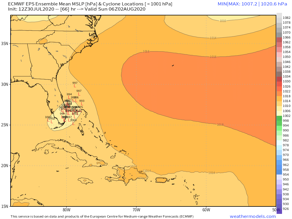
NDG wrote:Once the Isaias gets close to FL there's still is fairly big spread between the Euro ensemble members, track not written on stone yet.
NC hit, 100%

https://i.imgur.com/f9gvA9H.png


Ensemble seems split by strength, stronger to the right, weaker to the left.
3 likes   

User avatar
SouthFLTropics
Category 5
Category 5
Posts: 4236
Age: 50
Joined: Thu Aug 14, 2003 8:04 am
Location: Port St. Lucie, Florida

Re: ATL: ISAIAS - Models

#1651 Postby SouthFLTropics » Thu Jul 30, 2020 2:56 pm

Certainly nothing is written in stone. Anyone looking to sound the all clear due to a 2 or 3 day track needs not look to far to find evidence that they are frequently off. Case in point...recently deceased Hanna. Three days out was supposed to go in around Matagorda. It ended up South of Corpus Christi. That's around a 100 mile difference.

Image
7 likes   
Fourth Generation Florida Native

Personal Storm History: David 79, Andrew 92, Erin 95, Floyd 99, Irene 99, Frances 04, Jeanne 04, Wilma 05, Matthew 16, Irma 17, Ian 22, Nicole 22, Milton 24

Aric Dunn
Category 5
Category 5
Posts: 21238
Age: 42
Joined: Sun Sep 19, 2004 9:58 pm
Location: Ready for the Chase.
Contact:

Re: ATL: ISAIAS - Models

#1652 Postby Aric Dunn » Thu Jul 30, 2020 2:57 pm

we have a bit of an issue... lol

the 12z Euro 24 hours positions are essentially the current position....

So essentially 18 hours ahead of schedule..

Image
5 likes   
Note: If I make a post that is brief. Please refer back to previous posts for the analysis or reasoning. I do not re-write/qoute what my initial post said each time.
If there is nothing before... then just ask :)

Space & Atmospheric Physicist, Embry-Riddle Aeronautical University,
I believe the sky is falling...

JPmia
S2K Supporter
S2K Supporter
Posts: 1070
Joined: Thu Jun 03, 2004 11:01 pm
Location: Fort Lauderdale, FL

Re: ATL: ISAIAS - Models

#1653 Postby JPmia » Thu Jul 30, 2020 2:59 pm

Aric Dunn wrote:we have a bit of an issue... lol

the 12z Euro 24 hours positions are essentially the current position....

So essentially 18 hours ahead of schedule..

https://i.ibb.co/1nL1ydW/Capture.png

That's what I was afraid of.. the center reformations/speed is booking it, which would implications downstream.
1 likes   

WeatherEmperor
S2K Supporter
S2K Supporter
Posts: 4806
Age: 41
Joined: Thu Sep 04, 2003 2:54 pm
Location: South Florida

Re: ATL: ISAIAS - Models

#1654 Postby WeatherEmperor » Thu Jul 30, 2020 3:00 pm

Aric Dunn wrote:we have a bit of an issue... lol

the 12z Euro 24 hours positions are essentially the current position....

So essentially 18 hours ahead of schedule..

[url]https://i.ibb.co/1nL1ydW/Captul]


Do you think this means Isais will end up a bit further west as a result of this??
2 likes   

User avatar
SouthFLTropics
Category 5
Category 5
Posts: 4236
Age: 50
Joined: Thu Aug 14, 2003 8:04 am
Location: Port St. Lucie, Florida

Re: ATL: ISAIAS - Models

#1655 Postby SouthFLTropics » Thu Jul 30, 2020 3:04 pm

Aric, take a look at the 12z operational run though. It puts the 24 hour position closer to the NE coast of Cuba. Why are all of the ensembles dragging behind back on the North coast of Haiti?

Image
0 likes   
Fourth Generation Florida Native

Personal Storm History: David 79, Andrew 92, Erin 95, Floyd 99, Irene 99, Frances 04, Jeanne 04, Wilma 05, Matthew 16, Irma 17, Ian 22, Nicole 22, Milton 24

User avatar
NDG
S2K Supporter
S2K Supporter
Posts: 15446
Joined: Sun Jul 09, 2006 10:14 pm
Location: Orlando, FL

Re: ATL: ISAIAS - Models

#1656 Postby NDG » Thu Jul 30, 2020 3:05 pm

Aric Dunn wrote:we have a bit of an issue... lol

the 12z Euro 24 hours positions are essentially the current position....

So essentially 18 hours ahead of schedule..

https://i.ibb.co/1nL1ydW/Capture.png


That is not the correct forecast for 24 hrs, the image is for its 12 hr forecast, 0z position this evening.
This is the correct 24 hr position forecast.

Image
3 likes   

User avatar
chaser1
S2K Supporter
S2K Supporter
Posts: 5465
Age: 64
Joined: Sat Oct 15, 2005 5:59 pm
Location: Longwood, Fl

Re: ATL: ISAIAS - Models

#1657 Postby chaser1 » Thu Jul 30, 2020 3:05 pm

Aric Dunn wrote:we have a bit of an issue... lol

the 12z Euro 24 hours positions are essentially the current position....

So essentially 18 hours ahead of schedule..

https://i.ibb.co/1nL1ydW/Capture.png


Wait, I certainly get the implication...... but that map show's points quite a bit further west then where it's presently at.
0 likes   
Andy D

(For official information, please refer to the NHC and NWS products.)

AutoPenalti
Category 5
Category 5
Posts: 4030
Age: 29
Joined: Mon Aug 17, 2015 4:16 pm
Location: Ft. Lauderdale, Florida

Re: ATL: ISAIAS - Models

#1658 Postby AutoPenalti » Thu Jul 30, 2020 3:06 pm

If it's faster (iow, LLC is hopping around) it will have a short avenue to move away from the coast. That's something models are not latching onto considering WE HAVE YET TO FIND AN ACTUAL CENTER.
0 likes   
The posts in this forum are NOT official forecasts and should not be used as such. They are just the opinion of the poster and may or may not be backed by sound meteorological data. They are NOT endorsed by any professional institution or STORM2K. For official information, please refer to products from the NHC and NWS.


Model Runs Cheat Sheet:
GFS (5:30 AM/PM, 11:30 AM/PM)
HWRF, GFDL, UKMET, NAVGEM (6:30-8:00 AM/PM, 12:30-2:00 AM/PM)
ECMWF (1:45 AM/PM)

TCVN
is a weighted averaged

Aric Dunn
Category 5
Category 5
Posts: 21238
Age: 42
Joined: Sun Sep 19, 2004 9:58 pm
Location: Ready for the Chase.
Contact:

Re: ATL: ISAIAS - Models

#1659 Postby Aric Dunn » Thu Jul 30, 2020 3:08 pm

NDG wrote:
Aric Dunn wrote:we have a bit of an issue... lol

the 12z Euro 24 hours positions are essentially the current position....

So essentially 18 hours ahead of schedule..

https://i.ibb.co/1nL1ydW/Capture.png


That is not the correct forecast for 24 hrs, the image is for its 12 hr forecast, 0z position this evening.
This is the correct 24 hr position forecast.

https://i.imgur.com/AAHoMC0.png


So there is some bug with the weathernerds site ? I just took a screen shot.


edit : I see the issue. well we can cut that back down to being 4 hours ahead
0 likes   
Note: If I make a post that is brief. Please refer back to previous posts for the analysis or reasoning. I do not re-write/qoute what my initial post said each time.
If there is nothing before... then just ask :)

Space & Atmospheric Physicist, Embry-Riddle Aeronautical University,
I believe the sky is falling...

WeatherEmperor
S2K Supporter
S2K Supporter
Posts: 4806
Age: 41
Joined: Thu Sep 04, 2003 2:54 pm
Location: South Florida

Re: ATL: ISAIAS - Models

#1660 Postby WeatherEmperor » Thu Jul 30, 2020 3:10 pm

Arric,

On the image you posted....look right underneath the wind speed legend. It says F012hrs. The image from the other poster has the correct 24hr positions because his says F024hrs
3 likes   


Return to “2020”

Who is online

Users browsing this forum: No registered users and 9 guests