ATL: LAURA - Models

Moderator: S2k Moderators

Message
Author
User avatar
Hammy
Category 5
Category 5
Posts: 5849
Age: 42
Joined: Fri May 25, 2012 5:25 pm
Contact:

Re: ATL: LAURA - Models

#1841 Postby Hammy » Fri Aug 21, 2020 9:16 pm

NDG wrote:
NorthPalm-Rainman wrote:
NDG wrote:
This is the part when I use my brains, I never believed it when it blew it up in this area in its long range forecast, and you can go through my posts. That model doesn’t do well when conditions are not perfect, when SAL is nearby. But when it blows it up consistently when even global models show a fairly good upper level environment with no SAL around that’s when I put stock on it. It may not blow up to a Cat 4 like it shows but it surely will not be a weak hurricane.


Or it may not even become a Hurricane. What about that option?


With such UL conditions, is guaranteed it will become a hurricane, eventually at some point.


What were Erika's (2015) upper level conditions in the GoM like at the time for comparison? It came up in the storm thread and I don't have any satellite info once advisories were discontinued, but I remember the vortex surviving for awhile and going through the keys.
0 likes   
The above post is not official and should not be used as such. It is the opinion of the poster and may or may not be backed by sound meteorological data. It is not endorsed by any professional institution or storm2k.org. For official information, please refer to the NHC and NWS products.

SunnyThoughts
Category 5
Category 5
Posts: 2263
Joined: Wed Jul 09, 2003 12:42 pm
Location: Pensacola, Florida

Re: ATL: LAURA - Models

#1842 Postby SunnyThoughts » Fri Aug 21, 2020 9:17 pm

txag2005 wrote:As a Houstonian, this storm is pretty much scaring the hell out of me.


I think everyone along the gulf coast feels that way until the models get a better handle on the situation.
6 likes   

User avatar
DestinHurricane
Category 4
Category 4
Posts: 935
Joined: Tue May 01, 2018 8:05 am
Location: New York, NY

Re: ATL: LAURA - Models

#1843 Postby DestinHurricane » Fri Aug 21, 2020 9:19 pm

SunnyThoughts wrote:
txag2005 wrote:As a Houstonian, this storm is pretty much scaring the hell out of me.


I think everyone along the gulf coast feels that way until the models get a better handle on the situation.


Feeling pretty safe tonight in destin. Ridge will probably push this west.
0 likes   
Michael 2018

User avatar
jasons2k
Storm2k Executive
Storm2k Executive
Posts: 8245
Age: 51
Joined: Wed Jul 06, 2005 12:32 pm
Location: The Woodlands, TX

Re: ATL: LAURA - Models

#1844 Postby jasons2k » Fri Aug 21, 2020 9:22 pm

I have to admit, I have been so focused on TD14 that I haven't spent much time on Laura. I never expected it to be a major impact for the West Coast of Florida (or Texas for that matter). I figured it would either plow right into SE Florida or skirt through the straits and head towards Pensacola/Mobile.

I didn't expect Texas to be a real plausible scenario but that is looking increasingly likely.
6 likes   


Jag95
Category 1
Category 1
Posts: 438
Joined: Sat Aug 15, 2009 8:43 pm
Location: Mobile, AL

Re: ATL: LAURA - Models

#1846 Postby Jag95 » Fri Aug 21, 2020 9:32 pm

SunnyThoughts wrote:
txag2005 wrote:As a Houstonian, this storm is pretty much scaring the hell out of me.


I think everyone along the gulf coast feels that way until the models get a better handle on the situation.


It's a guessing game right now. I asked the roofer to wait until after next week to start on my house.
1 likes   

Blow_Hard
Tropical Storm
Tropical Storm
Posts: 156
Joined: Sun Aug 07, 2016 4:29 pm
Location: Panama City, FL

Re: ATL: LAURA - Models

#1847 Postby Blow_Hard » Fri Aug 21, 2020 9:35 pm

DestinHurricane wrote:
SunnyThoughts wrote:
txag2005 wrote:As a Houstonian, this storm is pretty much scaring the hell out of me.


I think everyone along the gulf coast feels that way until the models get a better handle on the situation.


Feeling pretty safe tonight in destin. Ridge will probably push this west.


Likewise here in Panama City. I mean I know the situation is fluid but it definitely looks like whatever happens is going to be far removed from us...
0 likes   

sphelps8681
Category 2
Category 2
Posts: 785
Joined: Thu Aug 16, 2007 5:37 pm
Location: Somewhere over the rainbow

Re: ATL: LAURA - Models

#1848 Postby sphelps8681 » Fri Aug 21, 2020 9:36 pm

Local met just did a live stating the storms will trend more west because of high pressure developing off to the east of Florida and being strong enough to push these systems on a westward trend. With TD14/Marco going toward Corpus/Mexico and Laura hitting Texas as a Hurricane according to the latest 18z run.
0 likes   

catskillfire51
S2K Supporter
S2K Supporter
Posts: 480
Age: 38
Joined: Sun Aug 26, 2012 5:40 pm
Location: Lake Jackson, TX

Re: ATL: LAURA - Models

#1849 Postby catskillfire51 » Fri Aug 21, 2020 9:41 pm

sphelps8681 wrote:Local met just did a live stating the storms will trend more west because of high pressure developing off to the east of Florida and being strong enough to push these systems on a westward trend. With TD14/Marco going toward Corpus/Mexico and Laura hitting Texas as a Hurricane according to the latest 18z run.


If you follow todays trends he could be right but tomorrow it could completely change. Just needs to be watched very closely
1 likes   

User avatar
Hammy
Category 5
Category 5
Posts: 5849
Age: 42
Joined: Fri May 25, 2012 5:25 pm
Contact:

Re: ATL: LAURA - Models

#1850 Postby Hammy » Fri Aug 21, 2020 9:45 pm

Image
Image

NAM follows the CMC and has Laura picking up vorticity from Hispaniola

Image
Image

50kt TS in the Gulf at the end of the run
1 likes   
The above post is not official and should not be used as such. It is the opinion of the poster and may or may not be backed by sound meteorological data. It is not endorsed by any professional institution or storm2k.org. For official information, please refer to the NHC and NWS products.

Astromanía
Category 2
Category 2
Posts: 779
Age: 26
Joined: Sat Aug 25, 2018 10:34 pm
Location: Monterrey, N.L, México

Re: ATL: LAURA - Models

#1851 Postby Astromanía » Fri Aug 21, 2020 9:49 pm

OMG another storm that I need to watch closely, what the hell...
1 likes   

User avatar
eastcoastFL
Category 5
Category 5
Posts: 3901
Age: 43
Joined: Thu Apr 12, 2007 12:29 pm
Location: Palm City, FL

Re: ATL: LAURA - Models

#1852 Postby eastcoastFL » Fri Aug 21, 2020 9:49 pm

Blown Away wrote:
toad strangler wrote:it's hard to believe we had the "Recurve to the EAST of FL" brigade here less than 48 hours ago

http://twitter.com/RyanMaue/status/1296977074591326208?s=20


Also it was @3 days ago the Euro went E of Florida...

Well the 18z EURO shifts way S of Cuba mostly to TX/Mexico and the 18z HWRF shifts N to Fl peninsula tip then FL panhandle...

Does any model really win?


The models and the humans are still completely split on this. No man nor machine has a friggin clue what we’ll be dealing with 48 hours from now so far. I guess that’s why us storm junkies find tracking hurricanes so exciting. It wouldn’t be as interesting if we already knew the outcome. But for safety sake it sure would be nice to have a better grasp with the islands and the CONUS in the crosshairs.
Last edited by eastcoastFL on Fri Aug 21, 2020 9:57 pm, edited 1 time in total.
6 likes   
Personal Forecast Disclaimer:
The posts in this forum are NOT official forecast and should not be used as such. They are just the opinion of the poster and may or may not be backed by sound meteorological data. They are NOT endorsed by any professional institution or storm2k.org. For official information, please refer to the NHC and NWS products.

User avatar
eastcoastFL
Category 5
Category 5
Posts: 3901
Age: 43
Joined: Thu Apr 12, 2007 12:29 pm
Location: Palm City, FL

Re: ATL: LAURA - Models

#1853 Postby eastcoastFL » Fri Aug 21, 2020 9:52 pm

SouthernBreeze wrote:Bit of history -

Only two times since 1851 have there been two tropical systems of at least tropical storm strength in the Gulf of Mexico simultaneously:

1. September 5, 1933 - Category 3 hurricane and a 65 mph tropical storm
2. June 18, 1959 - two tropical storms


Were Bonnie and Charlie ever in the gulf together? I know it was close but can’t remember if Bonnie was still a TS. Did them being in the same area so close together have any impact on the models failing with Charlie so badly?

Image
Last edited by eastcoastFL on Fri Aug 21, 2020 9:58 pm, edited 1 time in total.
0 likes   
Personal Forecast Disclaimer:
The posts in this forum are NOT official forecast and should not be used as such. They are just the opinion of the poster and may or may not be backed by sound meteorological data. They are NOT endorsed by any professional institution or storm2k.org. For official information, please refer to the NHC and NWS products.

User avatar
Hammy
Category 5
Category 5
Posts: 5849
Age: 42
Joined: Fri May 25, 2012 5:25 pm
Contact:

Re: ATL: LAURA - Models

#1854 Postby Hammy » Fri Aug 21, 2020 9:54 pm

eastcoastFL wrote:
SouthernBreeze wrote:Bit of history -

Only two times since 1851 have there been two tropical systems of at least tropical storm strength in the Gulf of Mexico simultaneously:

1. September 5, 1933 - Category 3 hurricane and a 65 mph tropical storm
2. June 18, 1959 - two tropical storms


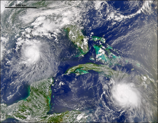
We’re Bonnie and Charlie ever in the gulf together? I know it was close but can’t remember if Bonnie was still a TS. Did them being in the same area so close together have any impact on the models failing with Charlie so badly?

https://eoimages.gsfc.nasa.gov/images/imagerecords/4000/4736/Bonnie-Charley_OSE2004224.jpg


I believe Charley emerged from Cuba roughly 12 hours after Bonnie's landfall, but that certainly looks like the closest we've come recently.
1 likes   
The above post is not official and should not be used as such. It is the opinion of the poster and may or may not be backed by sound meteorological data. It is not endorsed by any professional institution or storm2k.org. For official information, please refer to the NHC and NWS products.

User avatar
Kingarabian
S2K Supporter
S2K Supporter
Posts: 16003
Joined: Sat Aug 08, 2009 3:06 am
Location: Honolulu, Hawaii

Re: ATL: LAURA - Models

#1855 Postby Kingarabian » Fri Aug 21, 2020 9:59 pm

00z ICON rolling if anyone wants to post updates
0 likes   
RIP Kobe Bryant

User avatar
eastcoastFL
Category 5
Category 5
Posts: 3901
Age: 43
Joined: Thu Apr 12, 2007 12:29 pm
Location: Palm City, FL

Re: ATL: LAURA - Models

#1856 Postby eastcoastFL » Fri Aug 21, 2020 10:00 pm

Hammy wrote:
eastcoastFL wrote:
SouthernBreeze wrote:Bit of history -

Only two times since 1851 have there been two tropical systems of at least tropical storm strength in the Gulf of Mexico simultaneously:

1. September 5, 1933 - Category 3 hurricane and a 65 mph tropical storm
2. June 18, 1959 - two tropical storms


We’re Bonnie and Charlie ever in the gulf together? I know it was close but can’t remember if Bonnie was still a TS. Did them being in the same area so close together have any impact on the models failing with Charlie so badly?

https://eoimages.gsfc.nasa.gov/images/imagerecords/4000/4736/Bonnie-Charley_OSE2004224.jpg


I believe Charley emerged from Cuba roughly 12 hours after Bonnie's landfall, but that certainly looks like the closest we've come recently.


That’s the only one I remember since I started tracking storms at least the closest. I forgot about Wilma eating Alpha. I didn’t have electricity when that happened. I wonder if the Bonnie scenario had any effect on modeling. A land falling Bonnie and a Charlie coming off land had to be tough to forecast what would happen to Charlie.
0 likes   
Personal Forecast Disclaimer:
The posts in this forum are NOT official forecast and should not be used as such. They are just the opinion of the poster and may or may not be backed by sound meteorological data. They are NOT endorsed by any professional institution or storm2k.org. For official information, please refer to the NHC and NWS products.

User avatar
eastcoastFL
Category 5
Category 5
Posts: 3901
Age: 43
Joined: Thu Apr 12, 2007 12:29 pm
Location: Palm City, FL

Re: ATL: LAURA - Models

#1857 Postby eastcoastFL » Fri Aug 21, 2020 10:02 pm

Icon at 30 hours

Image
0 likes   
Personal Forecast Disclaimer:
The posts in this forum are NOT official forecast and should not be used as such. They are just the opinion of the poster and may or may not be backed by sound meteorological data. They are NOT endorsed by any professional institution or storm2k.org. For official information, please refer to the NHC and NWS products.

User avatar
Steve
S2K Supporter
S2K Supporter
Posts: 9621
Joined: Sat Apr 05, 2003 11:41 pm
Location: Not a state-caster

Re: ATL: LAURA - Models

#1858 Postby Steve » Fri Aug 21, 2020 10:03 pm

Hammy wrote:
eastcoastFL wrote:
SouthernBreeze wrote:Bit of history -

Only two times since 1851 have there been two tropical systems of at least tropical storm strength in the Gulf of Mexico simultaneously:

1. September 5, 1933 - Category 3 hurricane and a 65 mph tropical storm
2. June 18, 1959 - two tropical storms


We’re Bonnie and Charlie ever in the gulf together? I know it was close but can’t remember if Bonnie was still a TS. Did them being in the same area so close together have any impact on the models failing with Charlie so badly?

https://eoimages.gsfc.nasa.gov/images/imagerecords/4000/4736/Bonnie-Charley_OSE2004224.jpg


I believe Charley emerged from Cuba roughly 12 hours after Bonnie's landfall, but that certainly looks like the closest we've come recently.


That's right - only 1959 and 1933 had 2 named storms in the Gulf simultaneously at least in the last 100 years.
0 likes   

User avatar
toad strangler
S2K Supporter
S2K Supporter
Posts: 4543
Joined: Sun Jul 28, 2013 3:09 pm
Location: Earth
Contact:

Re: ATL: LAURA - Models

#1859 Postby toad strangler » Fri Aug 21, 2020 10:03 pm

00z ICON is all tied up in the Big Islands and entering SE Cuba through 39hrs
0 likes   

User avatar
Blown Away
S2K Supporter
S2K Supporter
Posts: 10152
Joined: Wed May 26, 2004 6:17 am

Re: ATL: LAURA - Models

#1860 Postby Blown Away » Fri Aug 21, 2020 10:07 pm

18z HWRF run is almost completely outside of the NHC cone.
Last edited by Blown Away on Fri Aug 21, 2020 10:08 pm, edited 1 time in total.
0 likes   
Hurricane Eye Experience: David 79, Irene 99, Frances 04, Jeanne 04, Wilma 05... EYE COMING MY WAY IN 2024…
Hurricane Brush Experience: Andrew 92, Erin 95, Floyd 99, Matthew 16, Irma 17, Ian 22, Nicole 22…


Return to “2020”

Who is online

Users browsing this forum: No registered users and 3 guests