eric blake from nhc lives close to your location..monitor his twitter, he worked the graveyard and did the write up so look for tweets from him to see what he is doing todaySFLcane wrote:jlauderdal wrote:good point...hispanola doesnt always weaken storms, strong systems dont always go poleward, they wont bust through ridges and if this ridge the euro is seeing is strong enough this becomes a florida landfalling system easily..the ten gas cans are loaded in the car and readySteve H. wrote:Stronger doesn't necessarily mean poleward. Ridging would trump that, like a top guided by a string.
Yep going to top the cars soon. Hopefully not a trend yikes
ATL: ISAIAS - Models
Moderator: S2k Moderators
-
jlauderdal
- S2K Supporter

- Posts: 7240
- Joined: Wed May 19, 2004 5:46 am
- Location: NE Fort Lauderdale
- Contact:
Re: ATL: ISAIAS - Models
1 likes

Re: ATL: ISAIAS - Models
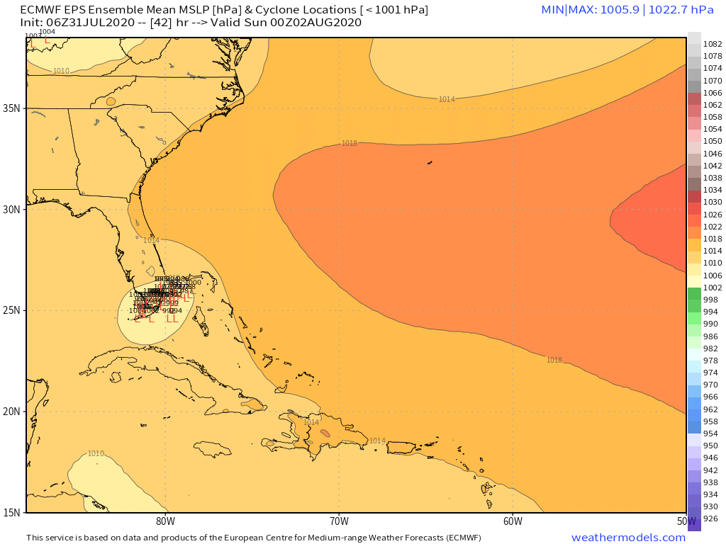
Closer look at the 06z Euro run, let the Hurricane warnings begin soon.

6 likes
-
AutoPenalti
- Category 5

- Posts: 4091
- Age: 29
- Joined: Mon Aug 17, 2015 4:16 pm
- Location: Ft. Lauderdale, Florida
Re: ATL: ISAIAS - Models
NDG wrote:Closer look at the 06z Euro run, let the Hurricane warnings begin soon.
https://i.imgur.com/PMaklFf.gif
I don’t think so if you have it weakening.
0 likes
The posts in this forum are NOT official forecasts and should not be used as such. They are just the opinion of the poster and may or may not be backed by sound meteorological data. They are NOT endorsed by any professional institution or STORM2K. For official information, please refer to products from the NHC and NWS.
Model Runs Cheat Sheet:
GFS (5:30 AM/PM, 11:30 AM/PM)
HWRF, GFDL, UKMET, NAVGEM (6:30-8:00 AM/PM, 12:30-2:00 AM/PM)
ECMWF (1:45 AM/PM)
TCVN is a weighted averaged
-
SFLcane

- S2K Supporter
- Posts: 10281
- Age: 48
- Joined: Sat Jun 05, 2010 1:44 pm
- Location: Lake Worth Florida
Re: ATL: ISAIAS - Models
jlauderdal wrote:eric blake from nhc lives close to your location..monitor his twitter, he worked the graveyard and did the write up so look for tweets from him to see what he is doing todaySFLcane wrote:jlauderdal wrote:good point...hispanola doesnt always weaken storms, strong systems dont always go poleward, they wont bust through ridges and if this ridge the euro is seeing is strong enough this becomes a florida landfalling system easily..the ten gas cans are loaded in the car and ready
Yep going to top the cars soon. Hopefully not a trend yikes
I know Eric lives real close to me.
0 likes
-
DESTRUCTION5

- Category 5
- Posts: 4430
- Age: 44
- Joined: Wed Sep 03, 2003 11:25 am
- Location: Stuart, FL
Re: ATL: ISAIAS - Models
NDG wrote:Closer look at the 06z Euro run, let the Hurricane warnings begin soon.
https://i.imgur.com/PMaklFf.gif
That's a total 180 there. Wow
0 likes
GATOR NATION IS E V E R Y W H E R E !
-
tarheelprogrammer

- S2K Supporter
- Posts: 1793
- Joined: Mon Mar 28, 2016 9:25 pm
- Location: Raleigh, NC area (Garner, NC)
Re: ATL: ISAIAS - Models
NDG wrote:Closer look at the 06z Euro run, let the Hurricane warnings begin soon.
https://i.imgur.com/PMaklFf.gif
Double post please delete mods.
Last edited by tarheelprogrammer on Fri Jul 31, 2020 7:37 am, edited 1 time in total.
0 likes
My posts are not official forecasts. They are just my opinion and may or may not be backed by sound meteorological data. They are NOT endorsed by any professional institution or storm2k.org. For official information, please refer to the NHC and NWS products.

Re: ATL: ISAIAS - Models
0 likes
-
tarheelprogrammer
- S2K Supporter
- Posts: 1793
- Joined: Mon Mar 28, 2016 9:25 pm
- Location: Raleigh, NC area (Garner, NC)
Re: ATL: ISAIAS - Models
NDG wrote:Closer look at the 06z Euro run, let the Hurricane warnings begin soon.
https://i.imgur.com/PMaklFf.gif
If that verifies then props are needed for the CMC. It sniffed this out the whole time. It seems like it has done a real good job so far this season. Anyone have data to back this up?
0 likes
My posts are not official forecasts. They are just my opinion and may or may not be backed by sound meteorological data. They are NOT endorsed by any professional institution or storm2k.org. For official information, please refer to the NHC and NWS products.
-
chris_fit

- Category 5
- Posts: 3261
- Age: 43
- Joined: Wed Sep 10, 2003 11:58 pm
- Location: Tampa Bay Area, FL
Re: ATL: ISAIAS - Models
NDG wrote:Closer look at the 06z Euro run, let the Hurricane warnings begin soon.
https://i.imgur.com/PMaklFf.gif
I like how it drops a few MB as it nears Lake O
3 likes
-
gatorcane

- S2K Supporter
- Posts: 23708
- Age: 48
- Joined: Sun Mar 13, 2005 3:54 pm
- Location: Boca Raton, FL
Re: ATL: ISAIAS - Models
Euro has SE Florida on the dirty side. Though not a hurricane would be very windy and squally. Even strong tropical waves are no picnic.
1 likes
-
TheStormExpert
Re: ATL: ISAIAS - Models
NDG wrote:Closer look at the 06z Euro run, let the Hurricane warnings begin soon.
https://i.imgur.com/PMaklFf.gif
Doesn’t look like a hurricane to me on there. I mean it’s going to hit tomorrow so putting up hurricane watches/warnings on such short notice would cause a lot of panic around here. Hopefully Isaias continues to struggle.
0 likes
-
northjaxpro

- S2K Supporter
- Posts: 8900
- Joined: Mon Sep 27, 2010 11:21 am
- Location: Jacksonville, FL
Re: ATL: ISAIAS - Models
NDG wrote:Closer look at the 06z Euro run, let the Hurricane warnings begin soon.
https://i.imgur.com/PMaklFf.gif
This 06Z run of the EURO is quite telling of the mid level steering. EURO just about takes Isaias to the Southeast GOM.
0 likes
NEVER, EVER SAY NEVER in the tropics and weather in general, and most importantly, with life itself!!
________________________________________________________________________________________
Fay 2008 Beryl 2012 Debby 2012 Colin 2016 Hermine 2016 Julia 2016 Matthew 2016 Irma 2017 Dorian 2019
________________________________________________________________________________________
Fay 2008 Beryl 2012 Debby 2012 Colin 2016 Hermine 2016 Julia 2016 Matthew 2016 Irma 2017 Dorian 2019
-
HurricaneFrances04
- Category 2

- Posts: 597
- Joined: Mon Jun 25, 2012 8:09 am
- Location: Fort Lauderdale, Florida
Re: ATL: ISAIAS - Models
Euro ensembles with a decent SW shift too. Does the NHC incorporate the 6z/18z Euro into their forecasts? Not sure I've seen them mention those runs before.
0 likes
Re: ATL: ISAIAS - Models
CMC continues to do a sneaky good job on picking up on trends early on. What does the CMC pick up that the other models don’t quite factor in as much. Super interesting!
2 likes
-
marciacubed
- S2K Supporter
- Posts: 122
- Joined: Tue Jul 22, 2003 11:52 am
- Location: Boynton Beach, Fl
- Contact:
Re: ATL: ISAIAS - Models
I think if they put up hurricane warnings they will have to open shelters. With the Covid issue they have a fine line to decide which is safer. If this is just going to be like severe afternoon storms people would not have to evacuate their homes.
1 likes
-
cp79
Re: ATL: ISAIAS - Models
northjaxpro wrote:NDG wrote:Closer look at the 06z Euro run, let the Hurricane warnings begin soon.
https://i.imgur.com/PMaklFf.gif
This 06Z run of the EURO is quite telling of the mid level steering. EURO just about takes Isaias to the Southeast GOM.
If it were to get to the Gulf, it will be sheared to pieces. It would probably be a naked swirl. Gulf is hostile right now.
2 likes
-
SFLcane
- S2K Supporter
- Posts: 10281
- Age: 48
- Joined: Sat Jun 05, 2010 1:44 pm
- Location: Lake Worth Florida
Re: ATL: ISAIAS - Models
HurricaneFrances04 wrote:Euro ensembles with a decent SW shift too. Does the NHC incorporate the 6z/18z Euro into their forecasts? Not sure I've seen them mention those runs before.
Holy..
0 likes
-
northjaxpro
- S2K Supporter
- Posts: 8900
- Joined: Mon Sep 27, 2010 11:21 am
- Location: Jacksonville, FL
Re: ATL: ISAIAS - Models
Powellrm wrote:CMC continues to do a sneaky good job on picking up on trends early on. What does the CMC pick up that the other models don’t quite factor in as much. Super interesting!
The CMC has done rather decent with modeling Isaias, along with the EURO in analyzing the ridging!
Last edited by northjaxpro on Fri Jul 31, 2020 7:57 am, edited 1 time in total.
0 likes
NEVER, EVER SAY NEVER in the tropics and weather in general, and most importantly, with life itself!!
________________________________________________________________________________________
Fay 2008 Beryl 2012 Debby 2012 Colin 2016 Hermine 2016 Julia 2016 Matthew 2016 Irma 2017 Dorian 2019
________________________________________________________________________________________
Fay 2008 Beryl 2012 Debby 2012 Colin 2016 Hermine 2016 Julia 2016 Matthew 2016 Irma 2017 Dorian 2019
-
MJGarrison
- Tropical Storm

- Posts: 146
- Joined: Wed Aug 30, 2017 7:26 pm
Re: ATL: ISAIAS - Models
Powellrm wrote:CMC continues to do a sneaky good job on picking up on trends early on. What does the CMC pick up that the other models don’t quite factor in as much. Super interesting!
Is this necessarily the case? There are a few reasons that the storm may end up further west—stronger ridge, weaker storm, etc. If the CMC has the right result for the wrong reason, its not really picking up on an early trend.
Sent from my iPad using Tapatalk
2 likes
-
DestinHurricane

- Category 4

- Posts: 935
- Joined: Tue May 01, 2018 8:05 am
- Location: New York, NY
Re: ATL: ISAIAS - Models
Remember folks, the 6Z/18Z Euro are not as reliable as 0Z/12Z. I wouldn't put too much weight in this 6Z run until the 12Z confirms.
0 likes
Michael 2018
Who is online
Users browsing this forum: No registered users and 45 guests