EPAC: ELIDA - Remnants
Moderator: S2k Moderators
-
Kingarabian

- S2K Supporter

- Posts: 16342
- Joined: Sat Aug 08, 2009 3:06 am
- Location: Honolulu, Hawaii
Re: EPAC: INVEST 91E
Based on the SHIPS forecasts, this does have the makings of a long tracking major hurricane.
1 likes
RIP Kobe Bryant
-
Yellow Evan

- Professional-Met

- Posts: 16222
- Age: 27
- Joined: Fri Jul 15, 2011 12:48 pm
- Location: Henderson, Nevada/Honolulu, HI
- Contact:
Re: EPAC: INVEST 91E
Kingarabian wrote:Based on the SHIPS forecasts, this does have the makings of a long tracking major hurricane.
SST's drop off in around 60 hours so if this wants to get strong it needs to do so now. Personally I am somewhat skeptical given its large size.
0 likes
-
Kingarabian
- S2K Supporter
- Posts: 16342
- Joined: Sat Aug 08, 2009 3:06 am
- Location: Honolulu, Hawaii
Re: EPAC: INVEST 91E
Yellow Evan wrote:Kingarabian wrote:Based on the SHIPS forecasts, this does have the makings of a long tracking major hurricane.
SST's drop off in around 60 hours so if this wants to get strong it needs to do so now. Personally I am somewhat skeptical given its large size.
Drops the SST's to around 25C which is not exactly death sentence so long it becomes a major in the immediate future. Models are a bit iffy on the long term track but it could eventually re-track over warmer waters.
0 likes
RIP Kobe Bryant
-
Nancy Smar

- Category 5

- Posts: 1081
- Age: 25
- Joined: Wed Aug 16, 2017 10:03 pm
Re: EPAC: Tropical Depression NINE-E
EP, 09, 2020080900, , BEST, 0, 145N, 1020W, 30, 1007, LO, 34, NEQ, 0, 0, 0, 0, 1010, 100, 60, 0, 0, E, 0, , 0, 0, NINE, M, 0, , 0, 0, 0, 0, genesis-num, 017, TRANSITIONED, epB12020 to ep092020,
0 likes
-
Yellow Evan
- Professional-Met
- Posts: 16222
- Age: 27
- Joined: Fri Jul 15, 2011 12:48 pm
- Location: Henderson, Nevada/Honolulu, HI
- Contact:
Re: EPAC: INVEST 91E
Kingarabian wrote:Yellow Evan wrote:Kingarabian wrote:Based on the SHIPS forecasts, this does have the makings of a long tracking major hurricane.
SST's drop off in around 60 hours so if this wants to get strong it needs to do so now. Personally I am somewhat skeptical given its large size.
Drops the SST's to around 25C which is not exactly death sentence so long it becomes a major in the immediate future. Models are a bit iffy on the long term track but it could eventually re-track over warmer waters.
Yea that's a good point as it's possible this does move over warmer water and with such a sharp SST gradient, small shifts south can make a big difference track wise, Still, 25C waters over a sharp SST gradient is less survivable than 25C waters much further west historically.
2 likes
-
cycloneye

- Admin

- Posts: 149214
- Age: 69
- Joined: Thu Oct 10, 2002 10:54 am
- Location: San Juan, Puerto Rico
Re: EPAC: NINE-E - Tropical Depression
Tropical Depression Nine-E Discussion Number 1
NWS National Hurricane Center Miami FL EP092020
1000 PM CDT Sat Aug 08 2020
Deep convection associated with the area of disturbed weather that
we have been monitoring to the south of Mexico has persisted for
more than 12 hours. Directional ambiguities from an earlier ASCAT-B
scatterometer overpass suggest that the system has a closed
circulation, and recent satellite imagery shows that convection is
increasing near the estimated center while banding features are
becoming better defined. The system has sufficient convective
organization and circulation to be designated as a tropical
depression, and advisories are being initiated. Based on a ship
report and the scatterometer data, the current intensity is
estimated to be near 30 kt. Upper-level outflow from the tropical
cyclone is becoming better defined, and the system will be moving
over warm waters and in a low-shear environment through early next
week. With these conducive factors for strengthening, the cyclone
is likely to become a tropical storm rather soon and a hurricane
within a couple of days. The official forecast is similar to the
model consensus but given the anticipated environment, this may be
conservative. By days 3-5, cooler waters will likely lead to
weakening.
Although the center is not yet very well defined, my best estimate
of initial motion is a fairly climatological 295/12 kt. The
steering pattern looks quite straightforward for the next several
days. A pronounced 500 mb ridge extending westward from the
southwest United States over the Pacific should maintain a
generally west-northwestward track for much of the forecast period.
Late in the period, as the cyclone weakens, the shallower
circulation should turn westward with the lower-level flow. The
official track forecast is mainly a combination of the simple and
corrected multi-model consensus solutions.
FORECAST POSITIONS AND MAX WINDS
INIT 09/0300Z 14.7N 102.6W 30 KT 35 MPH
12H 09/1200Z 15.6N 104.5W 35 KT 40 MPH
24H 10/0000Z 16.7N 107.0W 45 KT 50 MPH
36H 10/1200Z 17.8N 109.5W 55 KT 65 MPH
48H 11/0000Z 18.8N 112.1W 65 KT 75 MPH
60H 11/1200Z 19.7N 114.7W 75 KT 85 MPH
72H 12/0000Z 20.5N 117.3W 70 KT 80 MPH
96H 13/0000Z 21.4N 122.7W 55 KT 65 MPH
120H 14/0000Z 21.0N 127.0W 40 KT 45 MPH
$$
Forecaster Pasch

0 likes
Visit the Caribbean-Central America Weather Thread where you can find at first post web cams,radars
and observations from Caribbean basin members Click Here
and observations from Caribbean basin members Click Here

Re: EPAC: NINE-E - Tropical Depression
I’m going to be honest, I wasn’t expecting this to be designated so soon. I thought maybe midday tomorrow.
5 likes
Irene '11 Sandy '12 Hermine '16 5/15/2018 Derecho Fay '20 Isaias '20 Elsa '21 Henri '21 Ida '21
I am only a meteorology enthusiast who knows a decent amount about tropical cyclones. Look to the professional mets, the NHC, or your local weather office for the best information.
I am only a meteorology enthusiast who knows a decent amount about tropical cyclones. Look to the professional mets, the NHC, or your local weather office for the best information.
-
Astromanía
- Category 2

- Posts: 793
- Age: 27
- Joined: Sat Aug 25, 2018 10:34 pm
- Location: Monterrey, N.L, México
Re: EPAC: NINE-E - Tropical Depression
Revillagigedo islands under the gun again lol, seriously I want to talk to the few people that lives there, how can they resist many tropical cyclone impacts every year?
2 likes
-
Yellow Evan
- Professional-Met
- Posts: 16222
- Age: 27
- Joined: Fri Jul 15, 2011 12:48 pm
- Location: Henderson, Nevada/Honolulu, HI
- Contact:
Re: EPAC: NINE-E - Tropical Depression
Astromanía wrote:Revillagigedo islands under the gun again lol, seriously I want to talk to the few people that lives there, how can they resist many tropical cyclone impacts every year?
It’s been kind of a dream of mine to live there tbh.
4 likes
-
mrbagyo

- Category 5
- Posts: 3963
- Age: 33
- Joined: Thu Apr 12, 2012 9:18 am
- Location: 14.13N 120.98E
- Contact:
Re: EPAC: NINE-E - Tropical Depression

0 likes
The posts in this forum are NOT official forecast and should not be used as such. They are just the opinion of the poster and may or may not be backed by sound meteorological data. They are NOT endorsed by any professional institution or storm2k.org. For official information, please refer to RSMC, NHC and NWS products.
-
Yellow Evan
- Professional-Met
- Posts: 16222
- Age: 27
- Joined: Fri Jul 15, 2011 12:48 pm
- Location: Henderson, Nevada/Honolulu, HI
- Contact:
Re: EPAC: NINE-E - Tropical Depression
It’s large size and relative lack of size prevent me from not being sure this even becomes a hurricane with the way things are going this year. But I’m not super confident in said assessment either especially given this seems to be doing well so far.
0 likes
-
Kingarabian
- S2K Supporter
- Posts: 16342
- Joined: Sat Aug 08, 2009 3:06 am
- Location: Honolulu, Hawaii
-
cycloneye
- Admin
- Posts: 149214
- Age: 69
- Joined: Thu Oct 10, 2002 10:54 am
- Location: San Juan, Puerto Rico
Re: EPAC: ELIDA - Tropical Storm
Tropical Storm Elida Discussion Number 2
NWS National Hurricane Center Miami FL EP092020
400 AM CDT Sun Aug 09 2020
Deep convection associated with the cyclone has increased during the
past several hours, particularly in a band in the southeast
quadrant. Late-arriving ASCAT data valid around 0330 UTC revealed
that the cyclone's low-level wind structure was still somewhat
elongated in a SSW-NNE orientation. That said, the ASCAT data also
showed a few believable 30-35 kt vectors in the northeast quadrant
of the cyclone. That supports an intensity of 35 kt, making Elida
the 5th tropical storm of the 2020 eastern North Pacific season.
Even with the assistance of the ASCAT pass, it has been difficult to
track the center of the tropical storm this morning. The center of
Elida appears to have jumped somewhat northward since last night,
and further reformations of the center will be possible until the
system consolidates some more. The northward adjustment in the
position resulted in a slight adjustment to the track forecast in
that direction, but overall the tropical storm is still forecast to
move generally west-northwestward for the next several days, steered
by a mid-level ridge extending over northern Mexico and the
southwestern United States. A westward turn is likely near the end
of the forecast period as Elida weakens and low-level tradewinds
become the dominant steering mechanism. Overall the models are in
excellent agreement and confidence in the track forecast is fairly
high.
All of the statistical and regional hurricane intensity models
forecast Elida to strengthen and become a hurricane within 48 h.
Since the cyclone does not appear to have a tight inner-core yet,
only modest strengthening is forecast for the first 12 h, followed
by a faster rate after that. The extent of strengthening is still
highly uncertain, and the guidance ranges from a minimal to major
hurricane. The new NHC forecast is very similar to the previous one
and the multi-model consensus. Elida is forecast to weaken later
this week after it reaches cooler waters to the north.
FORECAST POSITIONS AND MAX WINDS
INIT 09/0900Z 15.8N 104.1W 35 KT 40 MPH
12H 09/1800Z 16.8N 106.1W 40 KT 45 MPH
24H 10/0600Z 17.9N 108.8W 55 KT 65 MPH
36H 10/1800Z 18.8N 111.2W 65 KT 75 MPH
48H 11/0600Z 19.7N 113.8W 75 KT 85 MPH
60H 11/1800Z 20.6N 116.4W 75 KT 85 MPH
72H 12/0600Z 21.2N 119.0W 70 KT 80 MPH
96H 13/0600Z 21.9N 123.5W 55 KT 65 MPH
120H 14/0600Z 21.5N 127.0W 35 KT 40 MPH
$$
Forecaster Zelinsky
0 likes
Visit the Caribbean-Central America Weather Thread where you can find at first post web cams,radars
and observations from Caribbean basin members Click Here
and observations from Caribbean basin members Click Here
-
cycloneye
- Admin
- Posts: 149214
- Age: 69
- Joined: Thu Oct 10, 2002 10:54 am
- Location: San Juan, Puerto Rico
Re: EPAC: ELIDA - Tropical Storm
Tropical Storm Elida Discussion Number 3
NWS National Hurricane Center Miami FL EP092020
1000 AM CDT Sun Aug 09 2020
Based on a 1128 UTC SSMIS pass, Elida appears to have developed a
well-defined low-level structure, with a clear center region
surrounded by a cyan ring in the 37-GHz channel. Dvorak
classifications from TAFB and SAB are still below tropical storm
strength, however the latest UW-CIMSS ADT up to 45 kt. Given the
improving microwave structure, I've opted to go on the higher side
of the intensity estimates, initializing the maximum wind speed at
40 kt.
The overnight tracking of Elida's center appears to have been
really good, as the recent microwave pass and first-light visible
imagery show it to be very close to where we thought it was. Elida
is moving west-northwestward, or 300/15 kt, to the south of a
mid-level ridge which extends from Texas west-southwestward across
northern Mexico and over the Pacific. This ridge should keep Elida
on a west-northwestward track for the next 3 days or so. After
that time, a weakening Elida should be steered by lower-level flow
and will begin to move more slowly toward the west on days 4 and 5.
This forecast unreasoning is unchanged from before, and since there
are no errant track models that deviate from this scenario, the new
NHC track forecast remains close to the multi-model consensus aids.
Elida's structure revealed in the recent microwave pass that the
cyclone is likely primed for continued intensification. With low
shear, sufficient ocean heat content, and plenty of mid-level
moisture, Elida is expected to strengthen to hurricane intensity
around this time tomorrow, with a peak intensity occurring in about
2 days. Given the new set of intensity guidance, the NHC forecast
has been raised during the first 2-3 days--not as high as the HCCA
model but very close to the HWRF and Florida State Superensemble.
Rapid intensification is not out of the question given Elida's
structure and environment, with the SHIPS RI guidance showing a
1-in-3 chance of a 30-kt increase over the next 24 hours. After 48
hours, Elida will begin to move over cooler waters, and increasing
southwesterly shear should cause a rather quick weakening trend.
In fact, global models show all of Elida's deep convection
dissipating--if not the entire system itself--by day 5, and the NHC
forecast calls for the cyclone to be post tropical by that time.
FORECAST POSITIONS AND MAX WINDS
INIT 09/1500Z 16.4N 105.4W 40 KT 45 MPH
12H 10/0000Z 17.3N 107.4W 55 KT 65 MPH
24H 10/1200Z 18.4N 109.9W 65 KT 75 MPH
36H 11/0000Z 19.3N 112.6W 80 KT 90 MPH
48H 11/1200Z 20.0N 115.2W 85 KT 100 MPH
60H 12/0000Z 20.7N 117.8W 80 KT 90 MPH
72H 12/1200Z 21.2N 120.1W 70 KT 80 MPH
96H 13/1200Z 21.5N 124.0W 50 KT 60 MPH
120H 14/1200Z 21.0N 127.0W 35 KT 40 MPH...POST-TROPICAL
$$
Forecaster Berg
0 likes
Visit the Caribbean-Central America Weather Thread where you can find at first post web cams,radars
and observations from Caribbean basin members Click Here
and observations from Caribbean basin members Click Here
-
Yellow Evan
- Professional-Met
- Posts: 16222
- Age: 27
- Joined: Fri Jul 15, 2011 12:48 pm
- Location: Henderson, Nevada/Honolulu, HI
- Contact:
Re: EPAC: ELIDA - Tropical Storm
Microwave shows an eyewall trying to form and there is the classic comma shape that is a sign of at least some intensification. Not a ton of convection over the center but it has been slowly increasing over the last 18-24 hours. I'm more bullish on Elida than I was yesterday. Dry air can easily pause intensification and time isn't on the storm's side considering SST's drop off hard in ~48 hours. Waters are very warm in the short term though and shear is low and mid level relative humidity values are quite high. A standard intensification rate of T1.0/day would yield a peak intensity of 75 knots, which I tentatively think is too conservative.
0 likes
-
Yellow Evan
- Professional-Met
- Posts: 16222
- Age: 27
- Joined: Fri Jul 15, 2011 12:48 pm
- Location: Henderson, Nevada/Honolulu, HI
- Contact:
Re: EPAC: ELIDA - Tropical Storm
* GFS version *
* EAST PACIFIC 2020 SHIPS INTENSITY FORECAST *
* IR SAT DATA AVAILABLE, OHC AVAILABLE *
* ELIDA EP092020 08/09/20 12 UTC *
TIME (HR) 0 6 12 18 24 36 48 60 72 84 96 108 120 132 144 156 168
V (KT) NO LAND 40 46 52 59 65 76 85 86 79 69 60 50 41 33 26 23 21
V (KT) LAND 40 46 52 59 65 76 85 86 79 69 60 50 41 33 26 23 21
V (KT) LGEM 40 45 51 56 61 71 77 76 68 57 47 39 32 26 22 18 16
Storm Type TROP TROP TROP TROP TROP TROP TROP TROP TROP TROP TROP TROP TROP TROP TROP TROP TROP
SHEAR (KT) 7 6 5 7 12 1 5 4 11 15 18 18 18 15 14 11 15
SHEAR ADJ (KT) 0 2 3 2 -1 -2 0 0 0 0 -2 -1 -2 0 2 5 1
SHEAR DIR 337 306 312 331 332 288 240 149 177 190 212 216 228 232 263 270 289
SST (C) 30.2 30.1 29.7 29.1 28.7 28.4 26.5 25.7 24.9 24.1 24.1 23.5 23.6 24.6 24.6 25.2 25.4
POT. INT. (KT) 169 168 163 157 153 150 130 121 113 103 103 97 98 108 108 116 118
200 MB T (C) -52.5 -52.0 -51.5 -51.7 -51.7 -50.9 -51.3 -50.8 -51.1 -51.0 -51.4 -51.7 -52.3 -52.5 -52.8 -52.4 -52.1
200 MB VXT (C) 0.2 0.1 0.2 0.3 0.6 0.5 0.6 0.9 0.9 0.6 0.4 0.1 -0.2 -0.5 -0.3 0.0 0.0
TH_E DEV (C) 6 7 7 6 6 5 3 2 1 1 1 1 1 1 1 2 3
700-500 MB RH 77 76 72 69 69 64 61 58 57 52 49 44 42 38 33 29 25
MODEL VTX (KT) 11 13 15 16 16 18 23 23 20 18 16 13 10 7 5 LOST LOST
850 MB ENV VOR 9 21 28 23 19 30 7 -5 -4 -5 21 42 48 50 45 46 38
200 MB DIV 50 38 49 36 27 42 8 14 15 22 23 7 13 -6 9 -7 -19
700-850 TADV -3 -1 -5 -13 -12 -10 -9 0 5 12 6 6 3 4 5 3 2
LAND (KM) 285 317 361 432 508 495 601 710 894 1023 1159 1318 1502 1664 1813 2039 2052
LAT (DEG N) 16.1 16.7 17.3 17.8 18.3 19.1 20.1 20.8 21.3 21.7 21.8 21.7 21.1 xx.x xx.x xx.x xx.x
LONG(DEG W) 104.7 106.2 107.6 108.8 110.0 112.5 115.2 117.7 120.3 122.6 124.4 126.2 127.9 xxx.x xxx.x xxx.x xxx.x
STM SPEED (KT) 16 15 14 12 13 13 13 12 12 9 8 9 8 7 9 12 12
HEAT CONTENT 37 30 22 15 12 10 1 0 0 0 0 0 0 0 0 0 0
FORECAST TRACK FROM OFCI INITIAL HEADING/SPEED (DEG/KT):300/ 15 CX,CY: -12/ 8
T-12 MAX WIND: 30 PRESSURE OF STEERING LEVEL (MB): 671 (MEAN=587)
GOES IR BRIGHTNESS TEMP. STD DEV. 50-200 KM RAD: 14.0 (MEAN=14.5)
% GOES IR PIXELS WITH T < -20 C 50-200 KM RAD: 92.0 (MEAN=65.0)
PRELIM RI PROB (DV .GE. 35 KT IN 36 HR): 50.5
INDIVIDUAL CONTRIBUTIONS TO INTENSITY CHANGE
6 12 18 24 36 48 60 72 84 96 108 120 132 144 156 168
------------------------------------------------------------------------------
SAMPLE MEAN CHANGE 0. 0. 1. 1. 1. 2. 1. 1. 0. -0. -1. -2. -3. -4. -4. -5.
SST POTENTIAL 0. 0. 1. 2. 6. 10. 13. 15. 16. 16. 15. 14. 12. 10. 9. 8.
VERTICAL SHEAR MAG 1. 1. 2. 3. 4. 6. 7. 7. 5. 3. 2. 1. -0. -1. -2. -2.
VERTICAL SHEAR ADJ -0. -0. -0. -0. 0. 0. 0. 0. 0. 0. -0. -0. -0. -0. 0. 0.
VERTICAL SHEAR DIR -0. -0. -1. -1. -2. -2. -3. -3. -3. -3. -2. -2. -2. -2. -2. -2.
PERSISTENCE 2. 3. 3. 3. 3. 2. 2. 2. 1. 2. 2. 2. 2. 2. 2. 2.
200/250 MB TEMP. -0. -0. -0. -1. -1. -1. -1. 0. 0. 1. 1. 0. -1. -2. -2. -2.
THETA_E EXCESS 0. 0. 0. 0. -0. -1. -2. -4. -5. -7. -8. -8. -9. -9. -10. -11.
700-500 MB RH 0. 0. 0. 0. 1. 1. 0. 0. 0. 0. -0. -0. -0. -1. -1. -2.
MODEL VTX TENDENCY 1. 2. 4. 5. 6. 12. 15. 14. 10. 7. 2. -1. -4. -6. -6. -6.
850 MB ENV VORTICITY -0. -0. -0. -0. -0. 0. 0. 0. 1. 1. 1. 0. 0. 0. 0. 0.
200 MB DIVERGENCE 0. 0. 0. 0. 0. -0. -1. -1. -1. -1. -1. -1. -1. -1. -0. -0.
850-700 T ADVEC 0. 0. 0. 0. 0. 0. -0. 0. -0. -0. 0. 0. 0. 0. 0. 1.
ZONAL STORM MOTION 0. 0. 1. 1. 1. 2. 2. 2. 2. 1. 1. 1. 1. 1. 1. -0.
STEERING LEVEL PRES 0. 0. 0. 1. 1. 1. 2. 2. 2. 2. 2. 2. 2. 1. 1. 0.
DAYS FROM CLIM. PEAK 0. 0. 0. 0. 0. 0. 0. 1. 1. 2. 2. 2. 2. 2. 3. 3.
GOES PREDICTORS 1. 2. 2. 2. 2. 2. 2. 2. 2. 2. 2. 2. 2. 2. 1. 1.
OCEAN HEAT CONTENT -0. 0. 0. 0. 0. -0. -0. -1. -0. -0. -0. 0. 1. 1. 2. 4.
RI POTENTIAL 1. 3. 6. 9. 14. 13. 8. 2. -1. -4. -7. -8. -8. -8. -8. -8.
------------------------------------------------------------------------------
TOTAL CHANGE 6. 12. 19. 25. 36. 45. 46. 39. 29. 20. 10. 1. -7. -14. -17. -19.
CURRENT MAX WIND (KT): 40. LAT, LON: 16.1 104.7
** 2020 E. Pacific RI INDEX EP092020 ELIDA 08/09/20 12 UTC **
(SHIPS-RII PREDICTOR TABLE for 30 KT OR MOREMAXIMUM WIND INCREASE IN NEXT 24-h)
Predictor Value RI Predictor Range Scaled Value(0-1) % Contribution
POT = MPI-VMAX (KT) : 122.0 40.5 to 149.3 0.75 7.8
12 HR PERSISTENCE (KT) : 10.0 -22.0 to 44.0 0.48 6.0
850-200 MB SHEAR (KT) : 7.5 19.6 to 1.4 0.66 6.3
D200 (10**7s-1) : 40.0 -33.0 to 160.6 0.38 3.7
MAXIMUM WIND (KT) : 40.0 22.5 to 132.0 0.50 3.6
STD DEV OF IR BR TEMP : 14.0 37.8 to 2.1 0.67 4.1
HEAT CONTENT (KJ/CM2) : 23.2 2.7 to 106.7 0.20 1.1
BL DRY-AIR FLUX (W/M2) : 90.0 800.8 to -82.5 0.80 -6.2
%area of TPW <45 mm upshear : 0.0 56.6 to 0.0 1.00 2.6
2nd PC OF IR BR TEMP : 0.6 2.2 to -1.9 0.39 0.3
SHIPS Prob RI for 20kt/ 12hr RI threshold= 19% is 3.0 times climatological mean ( 6.3%)
SHIPS Prob RI for 25kt/ 24hr RI threshold= 33% is 2.6 times climatological mean (12.6%)
SHIPS Prob RI for 30kt/ 24hr RI threshold= 29% is 3.4 times climatological mean ( 8.6%)
SHIPS Prob RI for 35kt/ 24hr RI threshold= 21% is 3.3 times climatological mean ( 6.2%)
SHIPS Prob RI for 40kt/ 24hr RI threshold= 16% is 3.7 times climatological mean ( 4.2%)
SHIPS Prob RI for 45kt/ 36hr RI threshold= 26% is 3.9 times climatological mean ( 6.7%)
SHIPS Prob RI for 55kt/ 48hr RI threshold= 25% is 4.2 times climatological mean ( 5.9%)
SHIPS Prob RI for 65kt/ 72hr RI threshold= 12% is 2.5 times climatological mean ( 4.7%)
Matrix of RI probabilities
------------------------------------------------------------------------------
RI (kt / h) | 20/12 | 25/24 | 30/24 | 35/24 | 40/24 | 45/36 | 55/48 |65/72
------------------------------------------------------------------------------
SHIPS-RII: 18.9% 32.9% 29.3% 20.6% 15.7% 26.3% 24.5% 11.7%
Logistic: 20.6% 47.7% 27.0% 16.6% 4.9% 19.4% 5.7% 1.9%
Bayesian: 3.8% 31.8% 8.3% 2.9% 1.0% 2.7% 0.4% 0.0%
Consensus: 14.4% 37.5% 21.6% 13.4% 7.2% 16.1% 10.2% 4.5%
DTOPS: 18.0% 35.0% 17.0% 8.0% 5.0% 36.0% 55.0% 8.0%
## ANNULAR HURRICANE INDEX (AHI) EP092020 ELIDA 08/09/20 12 UTC ##
## STORM NOT ANNULAR, SCREENING STEP FAILED, NPASS=3 NFAIL=4 ##
## AHI= 0 (AHI OF 100 IS BEST FIT TO ANN. STRUC., 1 IS MARGINAL, 0 IS NOT ANNULAR) ##
0 likes
-
Meteophile
- Tropical Depression

- Posts: 50
- Joined: Tue May 12, 2020 3:38 pm
-
Astromanía
- Category 2
- Posts: 793
- Age: 27
- Joined: Sat Aug 25, 2018 10:34 pm
- Location: Monterrey, N.L, México
Re: EPAC: ELIDA - Tropical Storm
Doing well so far, it is not dissapointing unlike other storms in this área this season
Last edited by Astromanía on Sun Aug 09, 2020 12:01 pm, edited 1 time in total.
1 likes
-
mrbagyo
- Category 5
- Posts: 3963
- Age: 33
- Joined: Thu Apr 12, 2012 9:18 am
- Location: 14.13N 120.98E
- Contact:
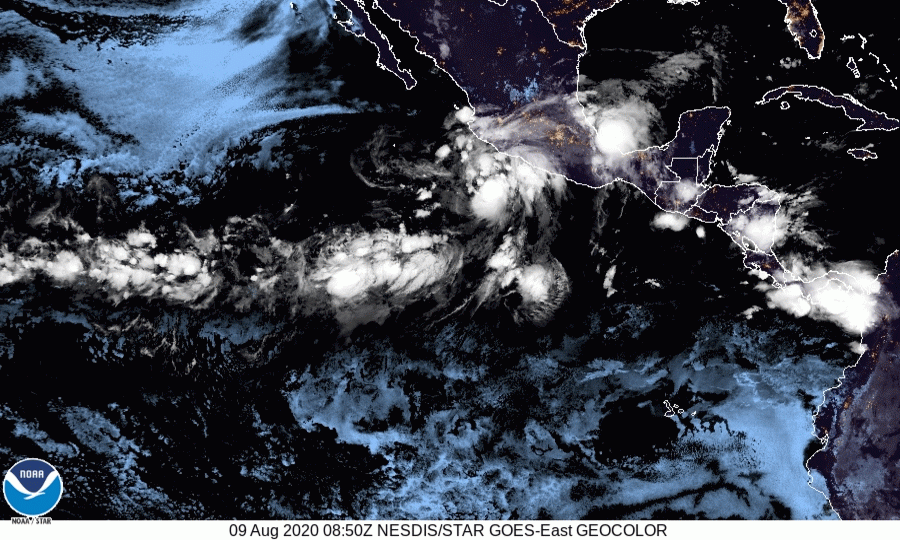
Re: EPAC: ELIDA - Tropical Storm
Decent core - it appears a microwave eye is about to form.

Visible

Visible
4 likes
The posts in this forum are NOT official forecast and should not be used as such. They are just the opinion of the poster and may or may not be backed by sound meteorological data. They are NOT endorsed by any professional institution or storm2k.org. For official information, please refer to RSMC, NHC and NWS products.

Who is online
Users browsing this forum: No registered users and 25 guests