15/1730 UTC 9.6N 91.3W T1.5/1.5 95E -- East Pacific
EPAC: GENEVIEVE - Post-Tropical
Moderator: S2k Moderators
-
Yellow Evan

- Professional-Met

- Posts: 16222
- Age: 27
- Joined: Fri Jul 15, 2011 12:48 pm
- Location: Henderson, Nevada/Honolulu, HI
- Contact:
-
Yellow Evan
- Professional-Met
- Posts: 16222
- Age: 27
- Joined: Fri Jul 15, 2011 12:48 pm
- Location: Henderson, Nevada/Honolulu, HI
- Contact:
Re: EPAC: INVEST 95E
* GFS version *
* EAST PACIFIC 2020 SHIPS INTENSITY FORECAST *
* IR SAT DATA AVAILABLE, OHC AVAILABLE *
* INVEST EP952020 08/15/20 18 UTC *
TIME (HR) 0 6 12 18 24 36 48 60 72 84 96 108 120 132 144 156 168
V (KT) NO LAND 30 35 40 47 54 67 82 92 103 105 106 101 96 87 79 74 68
V (KT) LAND 30 35 40 47 54 67 82 92 103 105 106 101 96 87 79 74 68
V (KT) LGEM 30 34 39 43 48 61 76 94 108 111 105 97 81 66 55 47 39
Storm Type TROP TROP TROP TROP TROP TROP TROP TROP TROP TROP TROP TROP TROP TROP TROP TROP TROP
SHEAR (KT) 14 13 11 5 4 3 14 7 7 7 7 6 10 12 10 8 12
SHEAR ADJ (KT) 0 -3 -2 0 0 -3 -6 -5 -4 -2 0 0 3 2 7 0 4
SHEAR DIR 80 74 68 49 64 100 105 94 136 147 150 145 176 194 204 151 155
SST (C) 28.8 29.0 29.3 29.5 29.5 29.9 30.0 30.2 29.4 29.1 28.3 27.1 25.3 24.8 24.6 23.4 22.5
POT. INT. (KT) 154 157 160 162 162 166 167 169 160 156 147 135 116 110 108 96 86
200 MB T (C) -52.8 -52.4 -52.8 -53.2 -52.9 -53.1 -52.7 -52.7 -52.1 -52.0 -51.7 -51.3 -51.0 -50.5 -50.5 -50.3 -50.4
200 MB VXT (C) 0.1 0.1 0.1 0.1 0.1 0.2 0.3 0.3 0.4 0.5 0.6 0.8 1.0 1.2 1.2 0.8 0.6
TH_E DEV (C) 4 4 4 3 5 5 7 7 7 7 6 5 4 4 2 1 0
700-500 MB RH 78 81 82 80 78 81 80 80 79 77 74 66 57 52 46 45 40
MODEL VTX (KT) 10 11 12 14 15 17 22 23 27 28 30 29 29 25 21 19 16
850 MB ENV VOR 67 52 41 34 38 39 43 49 69 57 80 69 67 61 49 64 40
200 MB DIV 111 111 105 109 104 145 143 140 117 109 62 34 12 18 1 -16 -2
700-850 TADV -1 -2 -1 0 0 0 -5 -9 0 0 1 -4 0 6 -3 -11 -1
LAND (KM) 471 487 523 545 524 500 508 502 512 525 431 426 424 472 549 595 668
LAT (DEG N) 9.6 xx.x xx.x xx.x xx.x xx.x xx.x xx.x xx.x xx.x xx.x xx.x xx.x xx.x xx.x xx.x xx.x
LONG(DEG W) 91.5 xxx.x xxx.x xxx.x xxx.x xxx.x xxx.x xxx.x xxx.x xxx.x xxx.x xxx.x xxx.x xxx.x xxx.x xxx.x xxx.x
STM SPEED (KT) 14 16 16 16 16 16 15 14 12 10 9 10 9 7 8 8 9
HEAT CONTENT 12 10 13 15 17 51 39 34 21 19 9 2 0 0 0 0 0
FORECAST TRACK FROM OFPI INITIAL HEADING/SPEED (DEG/KT):265/ 13 CX,CY: -12/ 0
T-12 MAX WIND: 20 PRESSURE OF STEERING LEVEL (MB): 485 (MEAN=587)
GOES IR BRIGHTNESS TEMP. STD DEV. 50-200 KM RAD: 24.8 (MEAN=14.5)
% GOES IR PIXELS WITH T < -20 C 50-200 KM RAD: 64.0 (MEAN=65.0)
PRELIM RI PROB (DV .GE. 35 KT IN 36 HR): 41.4
INDIVIDUAL CONTRIBUTIONS TO INTENSITY CHANGE
6 12 18 24 36 48 60 72 84 96 108 120 132 144 156 168
------------------------------------------------------------------------------
SAMPLE MEAN CHANGE 0. 0. 1. 1. 1. 2. 1. 1. 0. -0. -1. -2. -3. -4. -4. -5.
SST POTENTIAL 0. -0. 0. 1. 5. 11. 18. 23. 27. 30. 33. 34. 34. 34. 33. 32.
VERTICAL SHEAR MAG 0. 1. 2. 2. 4. 4. 4. 5. 5. 5. 6. 6. 5. 5. 4. 4.
VERTICAL SHEAR ADJ 0. 0. 0. 1. 1. 2. 2. 1. 1. 0. -0. -0. -0. -0. 0. 0.
VERTICAL SHEAR DIR 1. 2. 3. 4. 6. 8. 9. 9. 8. 7. 6. 5. 4. 3. 2. 2.
PERSISTENCE 2. 3. 3. 4. 3. 3. 2. 2. 2. 2. 2. 3. 2. 3. 3. 3.
200/250 MB TEMP. -0. -0. -0. -0. -1. -1. -1. -2. -2. -2. -1. 0. 1. 3. 4. 4.
THETA_E EXCESS -0. -1. -1. -1. -2. -2. -2. -2. -1. -2. -2. -2. -2. -3. -4. -5.
700-500 MB RH 0. 0. 1. 1. 1. 1. 2. 2. 2. 2. 2. 2. 2. 2. 2. 2.
MODEL VTX TENDENCY 0. 1. 3. 4. 6. 12. 16. 24. 26. 28. 25. 22. 16. 11. 8. 5.
850 MB ENV VORTICITY 0. 0. 0. 0. 0. -0. -0. -0. -1. -1. -1. -1. -1. -1. -1. -1.
200 MB DIVERGENCE 0. 1. 1. 1. 2. 3. 5. 7. 8. 8. 8. 6. 4. 2. 1. 0.
850-700 T ADVEC 0. 0. 0. -0. -0. 0. -0. 0. -0. -0. -0. -0. -0. -0. -0. -0.
ZONAL STORM MOTION 0. 0. 1. 1. 1. 2. 2. 2. 2. 1. 1. 1. 1. 1. 1. -0.
STEERING LEVEL PRES -0. -0. -1. -1. -1. -1. -1. -2. -2. -2. -2. -2. -2. -1. -1. -0.
DAYS FROM CLIM. PEAK 0. 0. 0. 0. 0. 0. 1. 1. 2. 2. 2. 3. 3. 3. 4. 4.
GOES PREDICTORS -0. -0. -0. -1. -1. -1. -1. -2. -2. -2. -3. -3. -3. -2. -2. -2.
OCEAN HEAT CONTENT 0. -0. -0. -0. 0. 0. 1. 1. 0. 0. 0. -0. -0. 0. 0. 1.
RI POTENTIAL 1. 3. 5. 7. 11. 10. 6. 2. -1. -3. -5. -6. -6. -6. -6. -6.
------------------------------------------------------------------------------
TOTAL CHANGE 5. 10. 17. 24. 37. 52. 62. 73. 75. 76. 71. 66. 57. 49. 44. 38.
CURRENT MAX WIND (KT): 30. LAT, LON: 9.6 91.5
** 2020 E. Pacific RI INDEX EP952020 INVEST 08/15/20 18 UTC **
(SHIPS-RII PREDICTOR TABLE for 30 KT OR MOREMAXIMUM WIND INCREASE IN NEXT 24-h)
Predictor Value RI Predictor Range Scaled Value(0-1) % Contribution
POT = MPI-VMAX (KT) : 129.2 40.5 to 149.3 0.82 8.1
12 HR PERSISTENCE (KT) : 10.0 -22.0 to 44.0 0.48 5.7
850-200 MB SHEAR (KT) : 9.2 19.6 to 1.4 0.57 5.2
D200 (10**7s-1) : 108.0 -33.0 to 160.6 0.73 6.9
MAXIMUM WIND (KT) : 30.0 22.5 to 132.0 0.21 1.5
STD DEV OF IR BR TEMP : 24.8 37.8 to 2.1 0.36 2.1
HEAT CONTENT (KJ/CM2) : 13.4 2.7 to 106.7 0.10 0.6
BL DRY-AIR FLUX (W/M2) : 21.8 800.8 to -82.5 0.88 -6.5
%area of TPW <45 mm upshear : 0.0 56.6 to 0.0 1.00 2.5
2nd PC OF IR BR TEMP : -0.2 2.2 to -1.9 0.58 0.4
SHIPS Prob RI for 20kt/ 12hr RI threshold= 11% is 1.7 times climatological mean ( 6.3%)
SHIPS Prob RI for 25kt/ 24hr RI threshold= 28% is 2.2 times climatological mean (12.6%)
SHIPS Prob RI for 30kt/ 24hr RI threshold= 27% is 3.1 times climatological mean ( 8.6%)
SHIPS Prob RI for 35kt/ 24hr RI threshold= 19% is 3.1 times climatological mean ( 6.2%)
SHIPS Prob RI for 40kt/ 24hr RI threshold= 0% is 0.0 times climatological mean ( 4.2%)
SHIPS Prob RI for 45kt/ 36hr RI threshold= 28% is 4.2 times climatological mean ( 6.7%)
SHIPS Prob RI for 55kt/ 48hr RI threshold= 46% is 7.7 times climatological mean ( 5.9%)
SHIPS Prob RI for 65kt/ 72hr RI threshold= 57% is 12.2 times climatological mean ( 4.7%)
Matrix of RI probabilities
------------------------------------------------------------------------------
RI (kt / h) | 20/12 | 25/24 | 30/24 | 35/24 | 40/24 | 45/36 | 55/48 |65/72
------------------------------------------------------------------------------
SHIPS-RII: 10.7% 28.0% 26.6% 19.0% 0.0% 28.3% 45.5% 57.4%
Logistic: 2.3% 32.3% 17.4% 9.2% 2.8% 42.7% 79.3% 80.8%
Bayesian: 0.6% 6.4% 5.8% 1.6% 0.1% 1.9% 2.8% 35.8%
Consensus: 4.5% 22.3% 16.6% 9.9% 1.0% 24.3% 42.6% 58.0%
DTOPS: 3.0% 25.0% 12.0% 7.0% 4.0% 14.0% 47.0% 95.0%
## ANNULAR HURRICANE INDEX (AHI) EP952020 INVEST 08/15/20 18 UTC ##
## STORM NOT ANNULAR, SCREENING STEP FAILED, NPASS=6 NFAIL=1 ##
## AHI= 0 (AHI OF 100 IS BEST FIT TO ANN. STRUC., 1 IS MARGINAL, 0 IS NOT ANNULAR) ##
0 likes

Re: EPAC: INVEST 95E
18z GFS has a hurricane in only 48 hours. It gets 95E together very quickly, but I would expect development to be slightly slower since the GFS has been way too optimistic with the EPac.
2 likes
Irene '11 Sandy '12 Hermine '16 5/15/2018 Derecho Fay '20 Isaias '20 Elsa '21 Henri '21 Ida '21
I am only a meteorology enthusiast who knows a decent amount about tropical cyclones. Look to the professional mets, the NHC, or your local weather office for the best information.
I am only a meteorology enthusiast who knows a decent amount about tropical cyclones. Look to the professional mets, the NHC, or your local weather office for the best information.
-
cycloneye

- Admin

- Posts: 149214
- Age: 69
- Joined: Thu Oct 10, 2002 10:54 am
- Location: San Juan, Puerto Rico
Re: EPAC: INVEST 95E
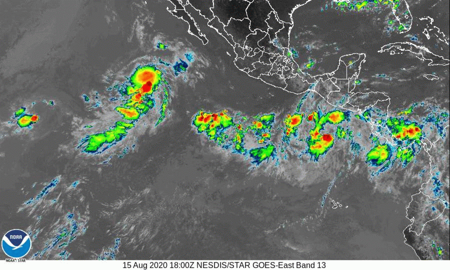
Showers and thunderstorms associated with a low pressure system
located a few hundred miles south-southeast of the Gulf of
Tehuantepec are showing signs of organization. Although this low is
still broad and elongated, environmental conditions appear conducive
for additional development, and a tropical depression or tropical
storm will likely form on Sunday. This system is expected to move
generally west-northwestward, well offshore the southwestern coast
of Mexico during the next few days.
* Formation chance through 48 hours...high...90 percent.
* Formation chance through 5 days...high...90 percent.
0 likes
Visit the Caribbean-Central America Weather Thread where you can find at first post web cams,radars
and observations from Caribbean basin members Click Here
and observations from Caribbean basin members Click Here
-
cycloneye
- Admin
- Posts: 149214
- Age: 69
- Joined: Thu Oct 10, 2002 10:54 am
- Location: San Juan, Puerto Rico
Re: EPAC: INVEST 95E
* EAST PACIFIC 2020 SHIPS INTENSITY FORECAST *
* IR SAT DATA AVAILABLE, OHC AVAILABLE *
* INVEST EP952020 08/16/20 00 UTC *
TIME (HR) 0 6 12 18 24 36 48 60 72 84 96 108 120 132 144 156 168
V (KT) NO LAND 30 35 42 51 60 75 90 99 102 101 100 93 87 79 71 65 59
V (KT) LAND 30 35 42 51 60 75 90 99 102 101 100 93 87 79 71 65 59
V (KT) LGEM 30 33 37 42 47 61 78 96 105 108 101 88 74 60 50 42 35
Storm Type TROP TROP TROP TROP TROP TROP TROP TROP TROP TROP TROP TROP TROP TROP TROP TROP TROP
SHEAR (KT) 10 5 5 6 6 1 8 7 9 10 7 6 10 14 12 12 17
SHEAR ADJ (KT) -3 0 0 -2 0 1 -1 -4 -6 -3 0 1 4 9 9 5 3
SHEAR DIR 80 69 31 108 96 172 142 124 130 151 167 122 164 188 185 185 196
SST (C) 29.1 29.5 29.6 29.6 29.7 29.9 30.4 29.8 29.0 28.7 27.3 26.0 24.9 24.5 24.1 22.5 21.7
POT. INT. (KT) 158 162 163 163 164 166 171 164 155 151 137 124 112 107 103 87 79
200 MB T (C) -52.5 -53.0 -53.2 -52.8 -52.4 -53.1 -52.1 -52.6 -51.8 -52.2 -51.2 -51.3 -50.5 -50.7 -50.1 -50.3 -50.1
200 MB VXT (C) 0.1 0.1 0.1 0.1 0.1 0.2 0.2 0.4 0.4 0.5 0.5 0.9 1.1 1.3 1.4 1.4 1.0
TH_E DEV (C) 5 4 3 5 6 5 8 8 8 6 6 5 4 2 1 0 0
700-500 MB RH 81 82 80 79 80 81 80 81 80 77 68 63 53 53 51 52 44
MODEL VTX (KT) 10 11 14 17 18 20 25 27 28 28 30 29 28 25 22 19 17
850 MB ENV VOR 51 37 38 35 40 39 47 45 68 68 78 63 47 62 55 57 31
200 MB DIV 104 109 113 105 139 122 154 109 112 77 52 25 27 6 -2 4 -9
700-850 TADV -1 0 0 2 0 -5 -5 -6 0 2 -2 -14 3 5 0 -4 1
LAND (KM) 446 487 500 470 456 481 466 453 479 425 313 338 405 481 498 579 710
LAT (DEG N) 10.4 xx.x xx.x xx.x xx.x xx.x xx.x xx.x xx.x xx.x xx.x xx.x xx.x xx.x xx.x xx.x xx.x
LONG(DEG W) 93.1 xxx.x xxx.x xxx.x xxx.x xxx.x xxx.x xxx.x xxx.x xxx.x xxx.x xxx.x xxx.x xxx.x xxx.x xxx.x xxx.x
STM SPEED (KT) 15 16 17 17 16 15 15 12 10 10 10 11 10 9 9 11 11
HEAT CONTENT 11 14 17 19 28 43 35 28 18 14 3 0 0 0 0 0 0
FORECAST TRACK FROM OFPI INITIAL HEADING/SPEED (DEG/KT):280/ 14 CX,CY: -13/ 2
T-12 MAX WIND: 25 PRESSURE OF STEERING LEVEL (MB): 507 (MEAN=587)
GOES IR BRIGHTNESS TEMP. STD DEV. 50-200 KM RAD: 16.7 (MEAN=14.5)
% GOES IR PIXELS WITH T < -20 C 50-200 KM RAD: 75.0 (MEAN=65.0)
PRELIM RI PROB (DV .GE. 35 KT IN 36 HR): 62.0
INDIVIDUAL CONTRIBUTIONS TO INTENSITY CHANGE
6 12 18 24 36 48 60 72 84 96 108 120 132 144 156 168
------------------------------------------------------------------------------
SAMPLE MEAN CHANGE 0. 0. 1. 1. 1. 2. 1. 1. 0. -0. -1. -2. -3. -4. -4. -5.
SST POTENTIAL -0. -0. -0. 1. 5. 11. 18. 23. 27. 30. 32. 33. 33. 32. 31. 29.
VERTICAL SHEAR MAG 1. 1. 2. 3. 5. 6. 7. 7. 7. 7. 7. 7. 7. 6. 4. 3.
VERTICAL SHEAR ADJ 0. 0. 0. 1. 1. 1. 1. 1. 1. 0. -0. -0. -0. -0. -0. -0.
VERTICAL SHEAR DIR 1. 1. 2. 3. 4. 4. 4. 4. 4. 3. 2. 1. 1. 1. 1. 1.
PERSISTENCE 1. 1. 1. 2. 1. 1. 1. 1. 1. 1. 1. 1. 1. 1. 1. 1.
200/250 MB TEMP. -0. -0. -0. -0. -1. -1. -1. -2. -2. -2. -1. 0. 2. 3. 5. 6.
THETA_E EXCESS -0. -1. -1. -1. -2. -2. -1. -1. -0. -0. -1. -1. -2. -3. -4. -6.
700-500 MB RH 0. 0. 1. 1. 1. 1. 2. 2. 2. 2. 2. 2. 1. 2. 2. 2.
MODEL VTX TENDENCY 0. 2. 5. 6. 7. 14. 20. 24. 25. 27. 24. 20. 16. 11. 8. 5.
850 MB ENV VORTICITY 0. 0. 0. 0. 0. -0. -0. -0. -1. -1. -1. -1. -1. -1. -1. -0.
200 MB DIVERGENCE 0. 1. 1. 1. 2. 3. 5. 7. 8. 8. 6. 5. 3. 2. 1. 0.
850-700 T ADVEC -0. -0. -0. -0. -0. 0. -0. 0. -0. -0. -0. -0. -0. -0. -0. -0.
ZONAL STORM MOTION 0. 0. 1. 1. 2. 2. 3. 2. 2. 2. 2. 2. 1. 1. 1. -0.
STEERING LEVEL PRES -0. -0. -0. -1. -1. -1. -1. -1. -1. -1. -1. -2. -1. -1. -1. -0.
DAYS FROM CLIM. PEAK 0. 0. 0. 0. 0. 0. 1. 1. 2. 2. 3. 3. 3. 3. 4. 4.
GOES PREDICTORS 1. 1. 1. 1. 1. 0. -0. -0. -1. -1. -1. -1. -1. -1. -1. -1.
OCEAN HEAT CONTENT 0. -0. -0. -0. 0. 1. 1. 1. 0. 0. 0. -0. 0. 0. 1. 1.
RI POTENTIAL 2. 4. 8. 12. 18. 17. 10. 3. -2. -6. -9. -11. -11. -11. -11. -11.
------------------------------------------------------------------------------
TOTAL CHANGE 5. 12. 21. 30. 45. 60. 69. 72. 71. 70. 64. 57. 49. 41. 35. 29.
CURRENT MAX WIND (KT): 30. LAT, LON: 10.4 93.1
** 2020 E. Pacific RI INDEX EP952020 INVEST 08/16/20 00 UTC **
(SHIPS-RII PREDICTOR TABLE for 30 KT OR MOREMAXIMUM WIND INCREASE IN NEXT 24-h)
Predictor Value RI Predictor Range Scaled Value(0-1) % Contribution
POT = MPI-VMAX (KT) : 132.2 40.5 to 149.3 0.84 9.0
12 HR PERSISTENCE (KT) : 5.0 -22.0 to 44.0 0.41 5.2
850-200 MB SHEAR (KT) : 6.6 19.6 to 1.4 0.72 7.0
D200 (10**7s-1) : 114.0 -33.0 to 160.6 0.76 7.7
MAXIMUM WIND (KT) : 30.0 22.5 to 132.0 0.21 1.6
STD DEV OF IR BR TEMP : 16.7 37.8 to 2.1 0.59 3.7
HEAT CONTENT (KJ/CM2) : 17.8 2.7 to 106.7 0.15 0.9
BL DRY-AIR FLUX (W/M2) : 22.8 800.8 to -82.5 0.88 -7.0
%area of TPW <45 mm upshear : 0.0 56.6 to 0.0 1.00 2.7
2nd PC OF IR BR TEMP : -0.5 2.2 to -1.9 0.65 0.5
SHIPS Prob RI for 20kt/ 12hr RI threshold= 15% is 2.4 times climatological mean ( 6.3%)
SHIPS Prob RI for 25kt/ 24hr RI threshold= 42% is 3.4 times climatological mean (12.6%)
SHIPS Prob RI for 30kt/ 24hr RI threshold= 31% is 3.6 times climatological mean ( 8.6%)
SHIPS Prob RI for 35kt/ 24hr RI threshold= 22% is 3.5 times climatological mean ( 6.2%)
SHIPS Prob RI for 40kt/ 24hr RI threshold= 0% is 0.0 times climatological mean ( 4.2%)
SHIPS Prob RI for 45kt/ 36hr RI threshold= 44% is 6.6 times climatological mean ( 6.7%)
SHIPS Prob RI for 55kt/ 48hr RI threshold= 69% is 11.7 times climatological mean ( 5.9%)
SHIPS Prob RI for 65kt/ 72hr RI threshold= 66% is 14.0 times climatological mean ( 4.7%)
Matrix of RI probabilities
------------------------------------------------------------------------------
RI (kt / h) | 20/12 | 25/24 | 30/24 | 35/24 | 40/24 | 45/36 | 55/48 |65/72
------------------------------------------------------------------------------
SHIPS-RII: 15.1% 42.4% 31.2% 21.7% 0.0% 44.3% 69.0% 65.9%
Logistic: 4.6% 41.7% 26.0% 15.6% 4.3% 59.5% 85.8% 78.4%
Bayesian: 1.1% 12.2% 10.3% 2.7% 0.3% 1.3% 3.0% 46.5%
Consensus: 6.9% 32.1% 22.5% 13.3% 1.5% 35.1% 52.6% 63.6%
DTOPS: 999.0% 999.0% 999.0% 999.0% 999.0% 999.0% 999.0% 999.0%
## ANNULAR HURRICANE INDEX (AHI) EP952020 INVEST 08/16/20 00 UTC ##
## STORM NOT ANNULAR, SCREENING STEP FAILED, NPASS=6 NFAIL=1 ##
## AHI= 0 (AHI OF 100 IS BEST FIT TO ANN. STRUC., 1 IS MARGINAL, 0 IS NOT ANNULAR) ##
0 likes
Visit the Caribbean-Central America Weather Thread where you can find at first post web cams,radars
and observations from Caribbean basin members Click Here
and observations from Caribbean basin members Click Here
-
Yellow Evan
- Professional-Met
- Posts: 16222
- Age: 27
- Joined: Fri Jul 15, 2011 12:48 pm
- Location: Henderson, Nevada/Honolulu, HI
- Contact:
-
gatorcane

- S2K Supporter

- Posts: 23708
- Age: 48
- Joined: Sun Mar 13, 2005 3:54 pm
- Location: Boca Raton, FL
Re: EPAC: INVEST 95E
Saved loop, should really start to take off over the next few days and rack up quite a bit of ACE:
0 likes
-
supercane4867
- Category 5

- Posts: 4966
- Joined: Wed Nov 14, 2012 10:43 am


-
Yellow Evan
- Professional-Met
- Posts: 16222
- Age: 27
- Joined: Fri Jul 15, 2011 12:48 pm
- Location: Henderson, Nevada/Honolulu, HI
- Contact:
Re: EPAC: INVEST 95E
Showers and thunderstorms associated with a low pressure system
located a few hundred miles south-southeast of the Gulf of
Tehuantepec continue to show signs of organization. Environmental
conditions appear conducive for additional development, and a
tropical depression or tropical storm will likely form on Sunday.
This system is expected to move generally west-northwestward, well
offshore of the southwestern coast of Mexico during the next few
days.
* Formation chance through 48 hours...high...90 percent.
* Formation chance through 5 days...high...90 percent.
0 likes
-
Yellow Evan
- Professional-Met
- Posts: 16222
- Age: 27
- Joined: Fri Jul 15, 2011 12:48 pm
- Location: Henderson, Nevada/Honolulu, HI
- Contact:
-
Yellow Evan
- Professional-Met
- Posts: 16222
- Age: 27
- Joined: Fri Jul 15, 2011 12:48 pm
- Location: Henderson, Nevada/Honolulu, HI
- Contact:
Re: EPAC: INVEST 95E
* GFS version *
* EAST PACIFIC 2020 SHIPS INTENSITY FORECAST *
* IR SAT DATA AVAILABLE, OHC AVAILABLE *
* INVEST EP952020 08/16/20 06 UTC *
TIME (HR) 0 6 12 18 24 36 48 60 72 84 96 108 120 132 144 156 168
V (KT) NO LAND 30 35 42 50 59 75 88 96 101 100 92 84 73 72 71 70 70
V (KT) LAND 30 35 42 50 59 75 88 96 101 100 92 84 73 72 71 70 70
V (KT) LGEM 30 32 35 39 43 55 70 88 100 101 91 76 63 N/A N/A N/A N/A
Storm Type TROP TROP TROP TROP TROP TROP TROP TROP TROP TROP TROP TROP TROP N/A N/A N/A N/A
SHEAR (KT) 5 3 6 6 4 9 8 8 10 10 7 10 17 N/A N/A N/A N/A
SHEAR ADJ (KT) 0 1 0 0 -1 -5 -3 -6 -4 -5 0 5 5 N/A N/A N/A N/A
SHEAR DIR 67 58 118 137 134 151 126 132 142 166 176 179 180 N/A N/A N/A N/A
SST (C) 29.6 29.7 29.6 29.8 30.0 30.3 30.1 29.1 28.7 27.4 25.8 25.0 24.4 N/A N/A N/A N/A
POT. INT. (KT) 163 164 163 165 167 170 168 157 152 138 121 113 107 N/A N/A N/A N/A
200 MB T (C) -53.1 -53.3 -52.9 -52.6 -53.0 -52.9 -52.4 -52.4 -52.2 -51.7 -51.2 -50.9 -50.4 N/A N/A N/A N/A
200 MB VXT (C) 0.1 0.1 0.1 0.2 0.2 0.3 0.3 0.3 0.4 0.4 0.5 0.8 0.9 N/A N/A N/A N/A
TH_E DEV (C) 4 4 5 6 5 7 8 8 7 6 5 4 2 N/A N/A N/A N/A
700-500 MB RH 81 81 79 79 80 78 78 78 77 69 59 56 51 N/A N/A N/A N/A
MODEL VTX (KT) 11 14 15 17 19 20 23 25 28 31 29 27 24 LOST LOST LOST LOST
850 MB ENV VOR 32 40 39 40 40 42 49 68 79 82 69 81 70 N/A N/A N/A N/A
200 MB DIV 100 108 101 143 122 111 117 102 86 41 14 13 -10 N/A N/A N/A N/A
700-850 TADV 0 0 0 -1 -4 -3 -5 -6 0 3 -7 -8 4 N/A N/A N/A N/A
LAND (KM) 482 469 454 445 463 441 463 490 439 357 367 390 454 N/A N/A N/A N/A
LAT (DEG N) 11.1 xx.x xx.x xx.x xx.x xx.x xx.x xx.x xx.x xx.x xx.x xx.x xx.x xx.x xx.x xx.x xx.x
LONG(DEG W) 95.0 xxx.x xxx.x xxx.x xxx.x xxx.x xxx.x xxx.x xxx.x xxx.x xxx.x xxx.x xxx.x xxx.x xxx.x xxx.x xxx.x
STM SPEED (KT) 17 17 16 16 16 15 14 12 11 10 10 11 10 N/A N/A N/A N/A
HEAT CONTENT 16 18 20 31 46 39 30 20 14 4 0 0 0 N/A N/A N/A N/A
FORECAST TRACK FROM OFPI INITIAL HEADING/SPEED (DEG/KT):290/ 18 CX,CY: -16/ 6
T-12 MAX WIND: 30 PRESSURE OF STEERING LEVEL (MB): 480 (MEAN=587)
GOES IR BRIGHTNESS TEMP. STD DEV. 50-200 KM RAD: 10.9 (MEAN=14.5)
% GOES IR PIXELS WITH T < -20 C 50-200 KM RAD: 91.0 (MEAN=65.0)
PRELIM RI PROB (DV .GE. 35 KT IN 36 HR): 64.9
INDIVIDUAL CONTRIBUTIONS TO INTENSITY CHANGE
6 12 18 24 36 48 60 72 84 96 108 120 132 144 156 168
------------------------------------------------------------------------------
SAMPLE MEAN CHANGE 0. 0. 1. 1. 1. 2. 1. 1. 0. -0. -1. -2. -3. -4. -4. -5.
SST POTENTIAL -0. -1. -1. 0. 5. 11. 18. 23. 27. 29. 31. 31. 33. 34. 35. 37.
VERTICAL SHEAR MAG 1. 2. 2. 3. 5. 6. 6. 6. 5. 5. 5. 4. 4. 4. 4. 4.
VERTICAL SHEAR ADJ 0. 0. 0. 0. 1. 1. 2. 1. 1. 0. -0. -0. -0. -0. 0. 0.
VERTICAL SHEAR DIR 1. 1. 2. 2. 2. 3. 3. 2. 2. 1. 1. 1. 1. 0. 0. 0.
PERSISTENCE -0. -0. -0. -1. -1. -1. -0. -0. -0. -0. -0. -0. -0. -0. -0. -0.
200/250 MB TEMP. 0. 0. -0. -0. -1. -1. -1. -1. -2. -1. -1. 0. 0. 1. 2. 2.
THETA_E EXCESS -0. -1. -1. -1. -1. -1. -1. -0. -0. -1. -1. -2. -2. -2. -2. -3.
700-500 MB RH 0. 0. 0. 1. 1. 1. 1. 2. 2. 2. 2. 1. 1. 2. 2. 3.
MODEL VTX TENDENCY 1. 2. 4. 6. 7. 11. 17. 23. 28. 24. 21. 15. 14. 13. 11. 10.
850 MB ENV VORTICITY 0. 0. 0. 0. 0. -0. -0. -0. -1. -1. -1. -1. -1. -1. -1. -1.
200 MB DIVERGENCE 0. 1. 1. 1. 2. 3. 5. 6. 6. 6. 5. 3. 3. 1. 1. 0.
850-700 T ADVEC -0. -0. -0. 0. 0. 0. -0. 0. -0. -0. -0. -0. -0. -0. -0. -1.
ZONAL STORM MOTION 0. 1. 1. 1. 2. 3. 4. 3. 3. 3. 3. 3. 2. 2. 1. -0.
STEERING LEVEL PRES -0. -0. -1. -1. -1. -1. -2. -2. -2. -2. -2. -2. -2. -1. -1. -0.
DAYS FROM CLIM. PEAK 0. 0. 0. 0. 0. 0. 1. 1. 2. 2. 3. 3. 3. 3. 4. 4.
GOES PREDICTORS 1. 2. 3. 3. 2. 2. 2. 1. 1. 1. 1. 1. 1. 1. 1. 0.
OCEAN HEAT CONTENT 0. -0. 0. 0. 0. 1. 1. 1. 0. 0. 0. 0. 0. 0. 0. -0.
RI POTENTIAL 2. 5. 8. 12. 19. 18. 11. 3. -2. -6. -10. -11. -12. -12. -12. -12.
------------------------------------------------------------------------------
TOTAL CHANGE 6. 12. 20. 29. 45. 58. 66. 71. 70. 62. 54. 43. 42. 41. 40. 40.
CURRENT MAX WIND (KT): 30. LAT, LON: 11.1 95.0
** 2020 E. Pacific RI INDEX EP952020 INVEST 08/16/20 06 UTC **
(SHIPS-RII PREDICTOR TABLE for 30 KT OR MOREMAXIMUM WIND INCREASE IN NEXT 24-h)
Predictor Value RI Predictor Range Scaled Value(0-1) % Contribution
POT = MPI-VMAX (KT) : 134.8 40.5 to 149.3 0.87 10.8
12 HR PERSISTENCE (KT) : 0.0 -22.0 to 44.0 0.33 4.9
850-200 MB SHEAR (KT) : 4.8 19.6 to 1.4 0.81 9.3
D200 (10**7s-1) : 114.8 -33.0 to 160.6 0.76 9.0
MAXIMUM WIND (KT) : 30.0 22.5 to 132.0 0.21 1.9
STD DEV OF IR BR TEMP : 10.9 37.8 to 2.1 0.75 5.5
HEAT CONTENT (KJ/CM2) : 26.2 2.7 to 106.7 0.23 1.6
BL DRY-AIR FLUX (W/M2) : 20.8 800.8 to -82.5 0.88 -8.1
%area of TPW <45 mm upshear : 0.0 56.6 to 0.0 1.00 3.1
2nd PC OF IR BR TEMP : -0.3 2.2 to -1.9 0.61 0.5
SHIPS Prob RI for 20kt/ 12hr RI threshold= 16% is 2.6 times climatological mean ( 6.3%)
SHIPS Prob RI for 25kt/ 24hr RI threshold= 58% is 4.6 times climatological mean (12.6%)
SHIPS Prob RI for 30kt/ 24hr RI threshold= 38% is 4.5 times climatological mean ( 8.6%)
SHIPS Prob RI for 35kt/ 24hr RI threshold= 28% is 4.5 times climatological mean ( 6.2%)
SHIPS Prob RI for 40kt/ 24hr RI threshold= 0% is 0.0 times climatological mean ( 4.2%)
SHIPS Prob RI for 45kt/ 36hr RI threshold= 46% is 6.9 times climatological mean ( 6.7%)
SHIPS Prob RI for 55kt/ 48hr RI threshold= 66% is 11.2 times climatological mean ( 5.9%)
SHIPS Prob RI for 65kt/ 72hr RI threshold= 63% is 13.5 times climatological mean ( 4.7%)
Matrix of RI probabilities
------------------------------------------------------------------------------
RI (kt / h) | 20/12 | 25/24 | 30/24 | 35/24 | 40/24 | 45/36 | 55/48 |65/72
------------------------------------------------------------------------------
SHIPS-RII: 16.4% 57.9% 38.4% 28.1% 0.0% 46.5% 66.2% 63.3%
Logistic: 22.8% 77.6% 67.7% 54.2% 22.9% 76.4% 77.5% 66.1%
Bayesian: 3.4% 21.9% 25.0% 9.4% 0.3% 14.2% 23.6% 36.7%
Consensus: 14.2% 52.5% 43.7% 30.6% 7.7% 45.7% 55.7% 55.4%
DTOPS: 4.0% 51.0% 33.0% 12.0% 6.0% 27.0% 31.0% 83.0%
## ANNULAR HURRICANE INDEX (AHI) EP952020 INVEST 08/16/20 06 UTC ##
## STORM NOT ANNULAR, SCREENING STEP FAILED, NPASS=4 NFAIL=3 ##
## AHI= 0 (AHI OF 100 IS BEST FIT TO ANN. STRUC., 1 IS MARGINAL, 0 IS NOT ANNULAR) ##
0 likes
-
cycloneye
- Admin
- Posts: 149214
- Age: 69
- Joined: Thu Oct 10, 2002 10:54 am
- Location: San Juan, Puerto Rico
Re: EPAC: INVEST 95E
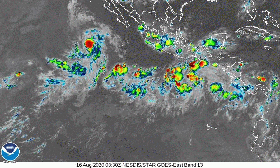
Showers and thunderstorms associated with a low pressure system
located a few hundred miles south of the Gulf of Tehuantepec have
continued to become better organized overnight, and it appears
that a tropical depression or storm is forming. If these
development trends continue, advisories will be issued on this
system this morning. The low is expected to move generally
west-northwestward, well offshore of the southwestern coast of
Mexico during the next few days. Additional information on this
system can be found in High Seas Forecasts issued by the National
Weather Service.
* Formation chance through 48 hours...high...near 100 percent.
* Formation chance through 5 days...high...near 100 percent.
0 likes
Visit the Caribbean-Central America Weather Thread where you can find at first post web cams,radars
and observations from Caribbean basin members Click Here
and observations from Caribbean basin members Click Here
-
cycloneye
- Admin
- Posts: 149214
- Age: 69
- Joined: Thu Oct 10, 2002 10:54 am
- Location: San Juan, Puerto Rico
Re: EPAC: TWELVE - Tropical Depression
12E TWELVE 200816 1200 11.1N 96.4W EPAC 30 1005
0 likes
Visit the Caribbean-Central America Weather Thread where you can find at first post web cams,radars
and observations from Caribbean basin members Click Here
and observations from Caribbean basin members Click Here
-
cycloneye
- Admin
- Posts: 149214
- Age: 69
- Joined: Thu Oct 10, 2002 10:54 am
- Location: San Juan, Puerto Rico
Re: EPAC: TWELVE-E - Tropical Depression
* EAST PACIFIC 2020 SHIPS INTENSITY FORECAST *
* IR SAT DATA AVAILABLE, OHC AVAILABLE *
* TWELVE EP122020 08/16/20 12 UTC *
TIME (HR) 0 6 12 18 24 36 48 60 72 84 96 108 120 132 144 156 168
V (KT) NO LAND 30 35 42 50 59 75 88 99 99 98 91 84 76 67 60 53 45
V (KT) LAND 30 35 42 50 59 75 88 99 99 98 91 84 76 67 60 53 45
V (KT) LGEM 30 32 34 38 42 53 69 88 98 97 86 73 60 48 40 32 25
Storm Type TROP TROP TROP TROP TROP TROP TROP TROP TROP TROP TROP TROP TROP TROP TROP TROP TROP
SHEAR (KT) 6 4 4 3 1 4 8 12 8 7 8 12 10 10 11 11 13
SHEAR ADJ (KT) 1 1 0 0 1 -1 -5 -5 -3 -1 1 3 3 5 3 5 3
SHEAR DIR 17 48 91 39 88 123 114 120 146 113 117 145 154 167 157 181 171
SST (C) 29.3 29.3 29.6 29.9 30.0 30.1 29.7 29.7 29.0 27.2 25.9 24.9 24.0 22.9 22.4 21.6 21.1
POT. INT. (KT) 160 160 163 166 167 168 163 163 155 136 122 112 103 91 86 77 72
200 MB T (C) -53.3 -53.0 -52.5 -53.0 -53.2 -52.2 -52.7 -52.0 -52.3 -51.2 -51.1 -50.6 -50.7 -50.2 -50.4 -50.4 -50.6
200 MB VXT (C) 0.1 0.1 0.1 0.2 0.3 0.2 0.4 0.4 0.5 0.4 0.6 0.8 1.0 1.2 1.0 0.9 0.7
TH_E DEV (C) 3 4 4 4 4 7 7 8 6 6 5 4 2 1 0 0 0
700-500 MB RH 81 81 80 80 80 79 80 78 76 67 60 52 52 50 51 47 47
MODEL VTX (KT) 12 15 17 19 21 22 23 28 27 28 27 26 25 21 20 18 15
850 MB ENV VOR 30 36 32 27 20 39 43 63 68 87 71 59 72 48 36 21 16
200 MB DIV 114 100 133 130 103 116 112 135 79 55 23 1 -7 -8 -4 0 11
700-850 TADV 1 -1 0 -2 -4 -5 -8 0 2 -3 -10 1 0 -5 -6 0 5
LAND (KM) 512 503 504 508 516 489 489 535 440 371 381 428 532 560 620 697 757
LAT (DEG N) 11.1 xx.x xx.x xx.x xx.x xx.x xx.x xx.x xx.x xx.x xx.x xx.x xx.x xx.x xx.x xx.x xx.x
LONG(DEG W) 96.4 xxx.x xxx.x xxx.x xxx.x xxx.x xxx.x xxx.x xxx.x xxx.x xxx.x xxx.x xxx.x xxx.x xxx.x xxx.x xxx.x
STM SPEED (KT) 16 15 16 16 16 14 13 12 10 9 10 10 10 10 10 9 8
HEAT CONTENT 15 16 24 52 48 34 26 25 15 3 0 0 0 0 0 0 0
FORECAST TRACK FROM OFPI INITIAL HEADING/SPEED (DEG/KT):285/ 16 CX,CY: -14/ 4
T-12 MAX WIND: 30 PRESSURE OF STEERING LEVEL (MB): 447 (MEAN=587)
GOES IR BRIGHTNESS TEMP. STD DEV. 50-200 KM RAD: 15.5 (MEAN=14.5)
% GOES IR PIXELS WITH T < -20 C 50-200 KM RAD: 92.0 (MEAN=65.0)
PRELIM RI PROB (DV .GE. 35 KT IN 36 HR): 65.2
INDIVIDUAL CONTRIBUTIONS TO INTENSITY CHANGE
6 12 18 24 36 48 60 72 84 96 108 120 132 144 156 168
------------------------------------------------------------------------------
SAMPLE MEAN CHANGE 0. 0. 1. 1. 1. 2. 1. 1. 0. -0. -1. -2. -3. -4. -4. -5.
SST POTENTIAL -0. -0. -0. 1. 5. 11. 18. 23. 27. 29. 31. 31. 30. 28. 26. 23.
VERTICAL SHEAR MAG 1. 2. 3. 4. 5. 7. 7. 7. 7. 7. 7. 7. 7. 6. 5. 4.
VERTICAL SHEAR ADJ -0. -0. -0. -0. 0. 0. 1. 1. 0. 0. -0. -0. -0. -0. -0. -0.
VERTICAL SHEAR DIR 0. 1. 2. 3. 4. 5. 5. 5. 4. 3. 2. 1. 1. 0. 0. 0.
PERSISTENCE -0. -0. -0. -1. -1. -1. -0. -0. -0. -0. -0. -0. -0. -0. -0. -0.
200/250 MB TEMP. 0. -0. -0. -0. -1. -1. -1. -2. -2. -1. -1. 0. 2. 3. 4. 4.
THETA_E EXCESS -0. -1. -1. -1. -2. -1. -1. -1. -1. -1. -2. -2. -4. -5. -6. -8.
700-500 MB RH 0. 0. 1. 1. 1. 1. 1. 2. 2. 2. 1. 1. 1. 1. 1. 1.
MODEL VTX TENDENCY 1. 3. 4. 6. 7. 10. 19. 21. 22. 21. 18. 15. 10. 8. 5. 2.
850 MB ENV VORTICITY 0. 0. 0. 0. 0. -0. -0. -0. -0. -1. -1. -1. -1. -1. -1. -0.
200 MB DIVERGENCE 0. 1. 1. 1. 2. 3. 5. 6. 7. 6. 5. 4. 2. 1. 1. 0.
850-700 T ADVEC -0. -0. -0. 0. 0. 0. -0. 0. -0. -0. -0. -0. -0. -0. -1. -1.
ZONAL STORM MOTION 0. 1. 1. 1. 2. 3. 3. 3. 2. 2. 2. 2. 2. 1. 1. -0.
STEERING LEVEL PRES -0. -0. -1. -1. -2. -2. -2. -2. -2. -3. -3. -3. -2. -2. -1. -0.
DAYS FROM CLIM. PEAK 0. 0. 0. 0. 0. 0. 1. 1. 2. 2. 3. 3. 3. 3. 4. 4.
GOES PREDICTORS 1. 2. 2. 2. 2. 2. 2. 2. 1. 1. 2. 2. 2. 1. 1. 1.
OCEAN HEAT CONTENT 0. -0. 0. 0. 0. 1. 1. 1. 0. 0. 0. -0. 0. 0. 1. 1.
RI POTENTIAL 2. 5. 8. 12. 19. 18. 11. 3. -2. -6. -10. -12. -12. -12. -12. -12.
------------------------------------------------------------------------------
TOTAL CHANGE 5. 12. 20. 29. 45. 58. 69. 69. 68. 61. 54. 46. 37. 30. 23. 15.
CURRENT MAX WIND (KT): 30. LAT, LON: 11.1 96.4
** 2020 E. Pacific RI INDEX EP122020 TWELVE 08/16/20 12 UTC **
(SHIPS-RII PREDICTOR TABLE for 30 KT OR MOREMAXIMUM WIND INCREASE IN NEXT 24-h)
Predictor Value RI Predictor Range Scaled Value(0-1) % Contribution
POT = MPI-VMAX (KT) : 133.3 40.5 to 149.3 0.85 10.5
12 HR PERSISTENCE (KT) : 0.0 -22.0 to 44.0 0.33 4.9
850-200 MB SHEAR (KT) : 3.8 19.6 to 1.4 0.87 9.8
D200 (10**7s-1) : 116.0 -33.0 to 160.6 0.77 9.0
MAXIMUM WIND (KT) : 30.0 22.5 to 132.0 0.21 1.9
STD DEV OF IR BR TEMP : 15.5 37.8 to 2.1 0.62 4.5
HEAT CONTENT (KJ/CM2) : 31.0 2.7 to 106.7 0.27 1.9
BL DRY-AIR FLUX (W/M2) : 18.6 800.8 to -82.5 0.89 -8.1
%area of TPW <45 mm upshear : 0.0 56.6 to 0.0 1.00 3.1
2nd PC OF IR BR TEMP : -0.3 2.2 to -1.9 0.62 0.5
SHIPS Prob RI for 20kt/ 12hr RI threshold= 15% is 2.4 times climatological mean ( 6.3%)
SHIPS Prob RI for 25kt/ 24hr RI threshold= 53% is 4.2 times climatological mean (12.6%)
SHIPS Prob RI for 30kt/ 24hr RI threshold= 38% is 4.4 times climatological mean ( 8.6%)
SHIPS Prob RI for 35kt/ 24hr RI threshold= 28% is 4.6 times climatological mean ( 6.2%)
SHIPS Prob RI for 40kt/ 24hr RI threshold= 0% is 0.0 times climatological mean ( 4.2%)
SHIPS Prob RI for 45kt/ 36hr RI threshold= 48% is 7.2 times climatological mean ( 6.7%)
SHIPS Prob RI for 55kt/ 48hr RI threshold= 66% is 11.2 times climatological mean ( 5.9%)
SHIPS Prob RI for 65kt/ 72hr RI threshold= 64% is 13.7 times climatological mean ( 4.7%)
Matrix of RI probabilities
------------------------------------------------------------------------------
RI (kt / h) | 20/12 | 25/24 | 30/24 | 35/24 | 40/24 | 45/36 | 55/48 |65/72
------------------------------------------------------------------------------
SHIPS-RII: 15.3% 52.8% 38.0% 28.2% 0.0% 47.9% 66.1% 64.4%
Logistic: 15.8% 74.6% 61.9% 46.5% 12.3% 76.7% 82.3% 66.1%
Bayesian: 2.7% 19.3% 14.2% 5.2% 0.5% 11.9% 12.1% 44.4%
Consensus: 11.3% 48.9% 38.0% 26.6% 4.3% 45.5% 53.5% 58.3%
DTOPS: 4.0% 48.0% 27.0% 7.0% 3.0% 18.0% 18.0% 79.0%
## ANNULAR HURRICANE INDEX (AHI) EP122020 TWELVE 08/16/20 12 UTC ##
## STORM NOT ANNULAR, SCREENING STEP FAILED, NPASS=3 NFAIL=4 ##
## AHI= 0 (AHI OF 100 IS BEST FIT TO ANN. STRUC., 1 IS MARGINAL, 0 IS NOT ANNULAR) ##
0 likes
Visit the Caribbean-Central America Weather Thread where you can find at first post web cams,radars
and observations from Caribbean basin members Click Here
and observations from Caribbean basin members Click Here
-
Yellow Evan
- Professional-Met
- Posts: 16222
- Age: 27
- Joined: Fri Jul 15, 2011 12:48 pm
- Location: Henderson, Nevada/Honolulu, HI
- Contact:
Re: EPAC: TWELVE-E - Tropical Depression
16/1130 UTC 11.2N 96.4W T2.0/2.0 95E -- East Pacific
0 likes
-
Nancy Smar

- Category 5
- Posts: 1081
- Age: 25
- Joined: Wed Aug 16, 2017 10:03 pm
Re: EPAC: TWELVE-E - Tropical Depression
EP, 12, 2020081612, 03, OFCL, 0, 111N, 964W, 30, 0, TD, 34, NEQ, 0, 0, 0, 0, 0, 0, 0, 40, 0,
EP, 12, 2020081612, 03, OFCL, 12, 119N, 995W, 40, 0, TS, 34, NEQ, 70, 30, 0, 70, 0, 0, 0, 50, 0,
EP, 12, 2020081612, 03, OFCL, 24, 129N, 1024W, 55, 0, TS, 34, NEQ, 100, 70, 50, 90, 0, 0, 0, 65, 0,
EP, 12, 2020081612, 03, OFCL, 24, 129N, 1024W, 55, 0, TS, 50, NEQ, 30, 20, 0, 20, 0, 0, 0, 65, 0,
EP, 12, 2020081612, 03, OFCL, 36, 143N, 1051W, 75, 0, HU, 34, NEQ, 120, 110, 80, 90, 0, 0, 0, 90, 0,
EP, 12, 2020081612, 03, OFCL, 36, 143N, 1051W, 75, 0, HU, 50, NEQ, 40, 30, 30, 30, 0, 0, 0, 90, 0,
EP, 12, 2020081612, 03, OFCL, 36, 143N, 1051W, 75, 0, HU, 64, NEQ, 20, 15, 15, 20, 0, 0, 0, 90, 0,
EP, 12, 2020081612, 03, OFCL, 48, 159N, 1074W, 90, 0, HU, 34, NEQ, 130, 130, 90, 100, 0, 0, 0, 110, 0,
EP, 12, 2020081612, 03, OFCL, 48, 159N, 1074W, 90, 0, HU, 50, NEQ, 50, 40, 30, 50, 0, 0, 0, 110, 0,
EP, 12, 2020081612, 03, OFCL, 48, 159N, 1074W, 90, 0, HU, 64, NEQ, 30, 20, 15, 20, 0, 0, 0, 110, 0,
EP, 12, 2020081612, 03, OFCL, 60, 175N, 1093W, 105, 0, HU, 34, NEQ, 140, 130, 100, 100, 0, 0, 0, 130, 0,
EP, 12, 2020081612, 03, OFCL, 60, 175N, 1093W, 105, 0, HU, 50, NEQ, 60, 50, 40, 50, 0, 0, 0, 130, 0,
EP, 12, 2020081612, 03, OFCL, 72, 192N, 1110W, 105, 0, HU, 34, NEQ, 140, 130, 100, 100, 0, 0, 0, 130, 0,
EP, 12, 2020081612, 03, OFCL, 72, 192N, 1110W, 105, 0, HU, 50, NEQ, 60, 50, 50, 60, 0, 0, 0, 130, 0,
EP, 12, 2020081612, 03, OFCL, 96, 216N, 1138W, 85, 0, HU, 34, NEQ, 0, 0, 0, 0, 0, 0, 0, 105, 0,
EP, 12, 2020081612, 03, OFCL, 120, 238N, 1177W, 60, 0, TS, 34, NEQ, 0, 0, 0, 0, 0, 0, 0, 75, 0,
0 likes
Re: EPAC: TWELVE-E - Tropical Depression
The 00z Euro shows rapid intensification between 48-72 hours, with the central pressure dropping from 991 to 968 mbar. This is one of the biggest pressure drops I’ve seen from this model.
0 likes
Irene '11 Sandy '12 Hermine '16 5/15/2018 Derecho Fay '20 Isaias '20 Elsa '21 Henri '21 Ida '21
I am only a meteorology enthusiast who knows a decent amount about tropical cyclones. Look to the professional mets, the NHC, or your local weather office for the best information.
I am only a meteorology enthusiast who knows a decent amount about tropical cyclones. Look to the professional mets, the NHC, or your local weather office for the best information.
-
EquusStorm
- Category 5
- Posts: 1649
- Age: 35
- Joined: Thu Nov 07, 2013 1:04 pm
- Location: Jasper, AL
- Contact:
Re: EPAC: TWELVE-E - Tropical Depression
If anything is gonna get anywhere near Douglas anytime soon this'll be the one to do it
0 likes
Colors of lost purpose on the canvas of irrelevance
Not a meteorologist, in fact more of an idiot than anything. You should probably check with the NHC or a local NWS office for official information.
Not a meteorologist, in fact more of an idiot than anything. You should probably check with the NHC or a local NWS office for official information.
-
cycloneye
- Admin
- Posts: 149214
- Age: 69
- Joined: Thu Oct 10, 2002 10:54 am
- Location: San Juan, Puerto Rico
Re: EPAC: TWELVE-E - Tropical Depression
Tropical Depression Twelve-E Discussion Number 1
NWS National Hurricane Center Miami FL EP122020
1000 AM CDT Sun Aug 16 2020
Deep convection associated with the area of low pressure located
south-southwest of the Gulf of Tehuantepec has increased and become
better organized overnight and this morning. In fact, bands of
convection can be seen in both visible and infrared satellite
imagery around the northwestern portion of the circulation. Dvorak
T-numbers from SAB and TAFB are a consensus 2.0, which supports an
initial intensity of 30 kt. The depression lies within a very
favorable environment for strengthening. These conditions
consisting of warm waters and low vertical wind shear are expected
to allow for rapid strengthening over the next 48-60 hours. Since
the system is still in its organizational stage, intensification is
likely to be a little more tempered today, but given these very
favorable conditions a period of rapid strengthening is anticipated
to begin by Monday and continue into Tuesday. The statistical
guidance and dynamical hurricane models are quite bullish on
deepening, as are the global models. The SHIPS RI index is
showing a 64 percent chance of a 65 kt increase in wind speed over
the next 72 hours. Since nearly all of the intensity guidance is
calling for a rather rapid increase in strength, this gives
relatively high confidence that the system will become a hurricane
in a day or two, and likely become a major hurricane within 72
hours. The NHC intensity forecast is a blend of the SHIPS and HFIP
correct consensus models.
The depression is moving west-northwestward or 285/16 kt. A strong
deep layer ridge of high pressure over the western United States
should steer the cyclone on a steady west-northwestward heading over
the next several days. The guidance suggests that there will be
some reduction in forward speed and a turn toward the northwest
later in the period as an upper-level low/trough retrogrades
westward well west of the Baja California peninsula. For the first
advisory package, the dynamical model guidance is tightly clustered
and the NHC track lies closest to the HFIP corrected consensus
model.
Although the tropical cyclone is forecast to remain well offshore
of the southern coast of Mexico, large swell generated by the
strengthening system are expected to begin affecting portions of
the coast of southern Mexico over the next day or so.
FORECAST POSITIONS AND MAX WINDS
INIT 16/1500Z 11.3N 97.3W 30 KT 35 MPH
12H 17/0000Z 11.9N 99.5W 40 KT 45 MPH
24H 17/1200Z 12.9N 102.4W 55 KT 65 MPH
36H 18/0000Z 14.3N 105.1W 75 KT 85 MPH
48H 18/1200Z 15.9N 107.4W 90 KT 105 MPH
60H 19/0000Z 17.5N 109.3W 105 KT 120 MPH
72H 19/1200Z 19.2N 111.0W 105 KT 120 MPH
96H 20/1200Z 21.6N 113.8W 85 KT 100 MPH
120H 21/1200Z 23.8N 117.7W 60 KT 70 MPH
$$
Forecaster Brown
2 likes
Visit the Caribbean-Central America Weather Thread where you can find at first post web cams,radars
and observations from Caribbean basin members Click Here
and observations from Caribbean basin members Click Here
Who is online
Users browsing this forum: No registered users and 25 guests