ATL: GAMMA - Post-Tropical - Discussion
Moderator: S2k Moderators

Re: ATL: INVEST 91L - Discussion
If the latest model runs play out, 91L might only hit the tip of the Yucatán Peninsula, lessening land impact as the system attempts to organize. However, the situation seems so complex that it’s best to nowcast and not look at the models until we have a defined TC.
4 likes
Irene '11 Sandy '12 Hermine '16 5/15/2018 Derecho Fay '20 Isaias '20 Elsa '21 Henri '21 Ida '21
I am only a meteorology enthusiast who knows a decent amount about tropical cyclones. Look to the professional mets, the NHC, or your local weather office for the best information.
I am only a meteorology enthusiast who knows a decent amount about tropical cyclones. Look to the professional mets, the NHC, or your local weather office for the best information.
-
MarioProtVI
- Category 5

- Posts: 1034
- Age: 24
- Joined: Sun Sep 29, 2019 7:33 pm
- Location: New Jersey
Re: ATL: INVEST 91L - Discussion
Latest GFS run takes 91L around the Yucatan into the BoC where it spins up to a hurricane before landfall in Veracruz. That area of the Yucatan is notorious for tightening up circulations going into the BoC...Karl 2010, Franklin 2017...even Cristobal as it formed earlier in the year.
0 likes
-
cycloneye

- Admin

- Posts: 149442
- Age: 69
- Joined: Thu Oct 10, 2002 10:54 am
- Location: San Juan, Puerto Rico
Re: ATL: INVEST 91L - Discussion
A well-defined tropical wave located over the western Caribbean Sea
is producing a large area of disorganized showers and thunderstorms.
Conditions are expected to be conducive for a tropical depression
to form by early next week, but only if the system moves and
remains over the waters of the northwestern Caribbean Sea or
southern Gulf of Mexico. Development will become less likely if the
system moves over the Yucatan Peninsula or northern Central America.
Regardless of development, this system is expected to produce
locally heavy rains, with possible flash flooding, over portions of
southeastern Mexico, Central America, and western Cuba during the
next several days, and interests in those areas should monitor the
progress of the disturbance.
* Formation chance through 48 hours...medium...40 percent.
* Formation chance through 5 days...high...70 percent.
0 likes
Visit the Caribbean-Central America Weather Thread where you can find at first post web cams,radars
and observations from Caribbean basin members Click Here
and observations from Caribbean basin members Click Here
-
wxman57

- Moderator-Pro Met

- Posts: 23174
- Age: 68
- Joined: Sat Jun 21, 2003 8:06 pm
- Location: Houston, TX (southwest)
Re: ATL: INVEST 91L - Discussion
aspen wrote:If the latest model runs play out, 91L might only hit the tip of the Yucatán Peninsula, lessening land impact as the system attempts to organize. However, the situation seems so complex that it’s best to nowcast and not look at the models until we have a defined TC.
Wish we had the luxury of not making a forecast until we're 100% confident where it's going. Will be starting a 7-day forecast by tomorrow morning. Models trending toward something similar to Stan of 2005. Crossing the northern Yucatan this weekend then tracking SW across BoC seems most likely. Tremendous amount of shear and dry air across northern Gulf. Not looking like a northern Gulf threat and most likely not tracking NE to Florida. Pretty sure we'll have Gamma by late this weekend.
8 likes
-
MarioProtVI
- Category 5
- Posts: 1034
- Age: 24
- Joined: Sun Sep 29, 2019 7:33 pm
- Location: New Jersey
Re: ATL: INVEST 91L - Discussion
cycloneye wrote:A well-defined tropical wave located over the western Caribbean Sea
is producing a large area of disorganized showers and thunderstorms.
Conditions are expected to be conducive for a tropical depression
to form by early next week, but only if the system moves and
remains over the waters of the northwestern Caribbean Sea or
southern Gulf of Mexico. Development will become less likely if the
system moves over the Yucatan Peninsula or northern Central America.
Regardless of development, this system is expected to produce
locally heavy rains, with possible flash flooding, over portions of
southeastern Mexico, Central America, and western Cuba during the
next several days, and interests in those areas should monitor the
progress of the disturbance.
* Formation chance through 48 hours...medium...40 percent.
* Formation chance through 5 days...high...70 percent.
I am not really buying the NHC saying Yucatan actually preventing this from forming. We’ve seen several storms in the past actually get organized or develop as it travels over this area.
0 likes
-
eastcoastFL

- Category 5
- Posts: 3996
- Age: 44
- Joined: Thu Apr 12, 2007 12:29 pm
- Location: Palm City, FL
Re: ATL: INVEST 91L - Discussion
Nor much shear in its current location. A good bit ahead of it In the gulf but who knows what the status will be when it gets there.

0 likes
Personal Forecast Disclaimer:
The posts in this forum are NOT official forecast and should not be used as such. They are just the opinion of the poster and may or may not be backed by sound meteorological data. They are NOT endorsed by any professional institution or storm2k.org. For official information, please refer to the NHC and NWS products.
The posts in this forum are NOT official forecast and should not be used as such. They are just the opinion of the poster and may or may not be backed by sound meteorological data. They are NOT endorsed by any professional institution or storm2k.org. For official information, please refer to the NHC and NWS products.
-
Miami Storm Tracker

- Category 4

- Posts: 916
- Age: 68
- Joined: Sun Jun 13, 2010 10:12 pm
- Location: Key Largo, Fla.
- Contact:
Re: ATL: INVEST 91L - Discussion
Is high pressure that strong that is steers this that far west? With the cool front draped across Florida you would think a ENE or NE direction would be there. Our local weather forecast is for 4 to 6 inches of rain. That will not happen if this get pushed further west.
2 likes
-
gatorcane

- S2K Supporter

- Posts: 23708
- Age: 48
- Joined: Sun Mar 13, 2005 3:54 pm
- Location: Boca Raton, FL
Re: ATL: INVEST 91L - Discussion
and the NHC finally committed to the Yucatan instead of just moving over the NW Caribbean Sea. Global models suggested this for days now (well except the GFS-P which took more time to come on board with that idea but we know it needs some fixing). Global models so far have handled this one well.
Last edited by gatorcane on Thu Oct 01, 2020 12:53 pm, edited 1 time in total.
0 likes

Re: ATL: INVEST 91L - Discussion
Miami Storm Tracker wrote:Is high pressure that strong that is steers this that far west? With the cool front draped across Florida you would think a ENE or NE direction would be there. Our local weather forecast is for 4 to 6 inches of rain. That will not happen if this get pushed further west.
A second cold front will prevent it from coming this way it will be blocked and hang out in the bay of campache.
0 likes
Robbielyn McCrary
I know just about enough to sound like I know what I'm talking about sometimes. But for your safety please follow the nhc for truly professional forecasting.
I know just about enough to sound like I know what I'm talking about sometimes. But for your safety please follow the nhc for truly professional forecasting.
Re: ATL: INVEST 91L - Discussion
Miami Storm Tracker wrote:Is high pressure that strong that is steers this that far west? With the cool front draped across Florida you would think a ENE or NE direction would be there. Our local weather forecast is for 4 to 6 inches of rain. That will not happen if this get pushed further west.
The heavy rain over south florida is going to happen with or without a tc. The frontal boundary will do the trick. This system is likely headed westward but plenty of water will be falling regardless
https://www.wpc.ncep.noaa.gov/threats/threats.php
4 likes
-
jlauderdal
- S2K Supporter
- Posts: 7240
- Joined: Wed May 19, 2004 5:46 am
- Location: NE Fort Lauderdale
- Contact:
Re: ATL: INVEST 91L - Discussion
THere is a flash flood watch through Sunday night...whenw as the last time you saw one issued for 72h...the stalled front is responsible, not the tropics although some moisture and energy may make it from the current system but really it will have minmail effect.Miami Storm Tracker wrote:Is high pressure that strong that is steers this that far west? With the cool front draped across Florida you would think a ENE or NE direction would be there. Our local weather forecast is for 4 to 6 inches of rain. That will not happen if this get pushed further west.
0 likes
-
Miami Storm Tracker
- Category 4
- Posts: 916
- Age: 68
- Joined: Sun Jun 13, 2010 10:12 pm
- Location: Key Largo, Fla.
- Contact:
Re: ATL: INVEST 91L - Discussion
So storm or no storm, my boating weekend in the keys is a wash out.
2 likes
-
jlauderdal
- S2K Supporter
- Posts: 7240
- Joined: Wed May 19, 2004 5:46 am
- Location: NE Fort Lauderdale
- Contact:
Re: ATL: INVEST 91L - Discussion
not necessarily, nobody said it was going to rain all day, everyday..pick your spotsMiami Storm Tracker wrote:So storm or no storm, my boating weekend in the keys is a wash out.
0 likes
-
wxman57
- Moderator-Pro Met
- Posts: 23174
- Age: 68
- Joined: Sat Jun 21, 2003 8:06 pm
- Location: Houston, TX (southwest)
Re: ATL: INVEST 91L - Discussion
MarioProtVI wrote:I am not really buying the NHC saying Yucatan actually preventing this from forming. We’ve seen several storms in the past actually get organized or develop as it travels over this area.
The NHC folks are implying that it may not move back offshore into the BoC in that discussion. If it moves into the BoC, then it will very likely develop.
2 likes
-
cycloneye
- Admin
- Posts: 149442
- Age: 69
- Joined: Thu Oct 10, 2002 10:54 am
- Location: San Juan, Puerto Rico
Re: ATL: INVEST 91L - Discussion
0 likes
Visit the Caribbean-Central America Weather Thread where you can find at first post web cams,radars
and observations from Caribbean basin members Click Here
and observations from Caribbean basin members Click Here

Re: ATL: INVEST 91L - Discussion
North coast of Honduras may close off and tighten a Low level circulation.
Low level clouds are almost stationary right along the coast currently.
Low level clouds are almost stationary right along the coast currently.
2 likes
Re: ATL: INVEST 91L - Discussion
Our local met on KLFY TV 10 in Lafayette, La., stated that some models are showing this getting into the Southern Gulf and sit there for a week to 3 weeks, due to all the cold fronts coming down and keeping it from moving anywhere.
0 likes
Personal Forecast Disclaimer:
The posts in this forum are NOT official forecast and should not be used as such. They are just the opinion of the poster and may or may not be backed by sound meteorological data. They are NOT endorsed by any professional institution or storm2k.org. For official information, please refer to the NHC and NWS products.
The posts in this forum are NOT official forecast and should not be used as such. They are just the opinion of the poster and may or may not be backed by sound meteorological data. They are NOT endorsed by any professional institution or storm2k.org. For official information, please refer to the NHC and NWS products.

Re: ATL: INVEST 91L - Discussion
Blinhart wrote:Our local met on KLFY TV 10 in Lafayette, La., stated that some models are showing this getting into the Southern Gulf and sit there for a week to 3 weeks, due to all the cold fronts coming down and keeping it from moving anywhere.
A buddy of mine sent me the Euro ensembles and according to him showed a bunch of different solutions, ranging from Southern Mexico to the Florida Panhandle, with additional potential landfalls in Texas and Louisiana for good measure. I'm not saying it can't happen, but if fronts keep coming down, at some point it has to get lifted out.
0 likes
Personal Forecast Disclaimer:
The posts in this forum are NOT official forecast and should not be used as such. They are just the opinion of the poster and may or may not be backed by sound meteorological data. They are NOT endorsed by any professional institution or storm2k.org. For official information, please refer to the NHC and NWS products.
The posts in this forum are NOT official forecast and should not be used as such. They are just the opinion of the poster and may or may not be backed by sound meteorological data. They are NOT endorsed by any professional institution or storm2k.org. For official information, please refer to the NHC and NWS products.
-
Hypercane_Kyle

- Category 5
- Posts: 3465
- Joined: Sat Mar 07, 2015 7:58 pm
- Location: Cape Canaveral, FL
Re: ATL: INVEST 91L - Discussion
Seems to me that if the LLC develops along the northern edge of the convective envelope, it may just be able to thread the needle between the Yucatan and Cuba.
0 likes
My posts are my own personal opinion, defer to the National Hurricane Center (NHC) and other NOAA products for decision making during hurricane season.
-
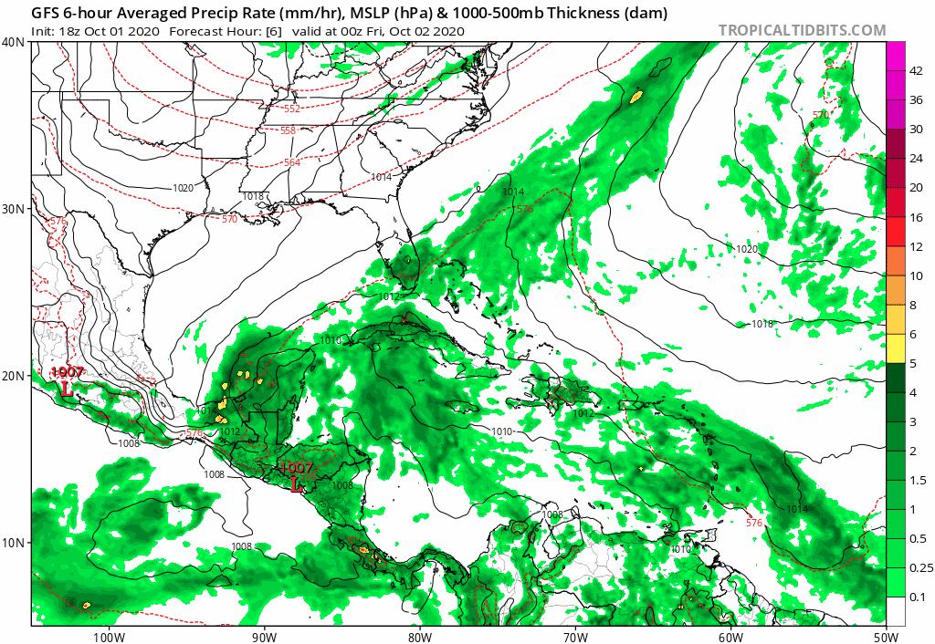
gatorcane
- S2K Supporter
- Posts: 23708
- Age: 48
- Joined: Sun Mar 13, 2005 3:54 pm
- Location: Boca Raton, FL
Re: ATL: INVEST 91L - Discussion
18Z GFS stronger and buries in the BOC. Odd pattern as the storm gets north of the Yucatan and still goes SW:
3 likes
Who is online
Users browsing this forum: No registered users and 22 guests