ATL: ZETA - Models
Moderator: S2k Moderators
- gatorcane
- S2K Supporter

- Posts: 23708
- Age: 48
- Joined: Sun Mar 13, 2005 3:54 pm
- Location: Boca Raton, FL
Re: ATL: INVEST 95L - Models
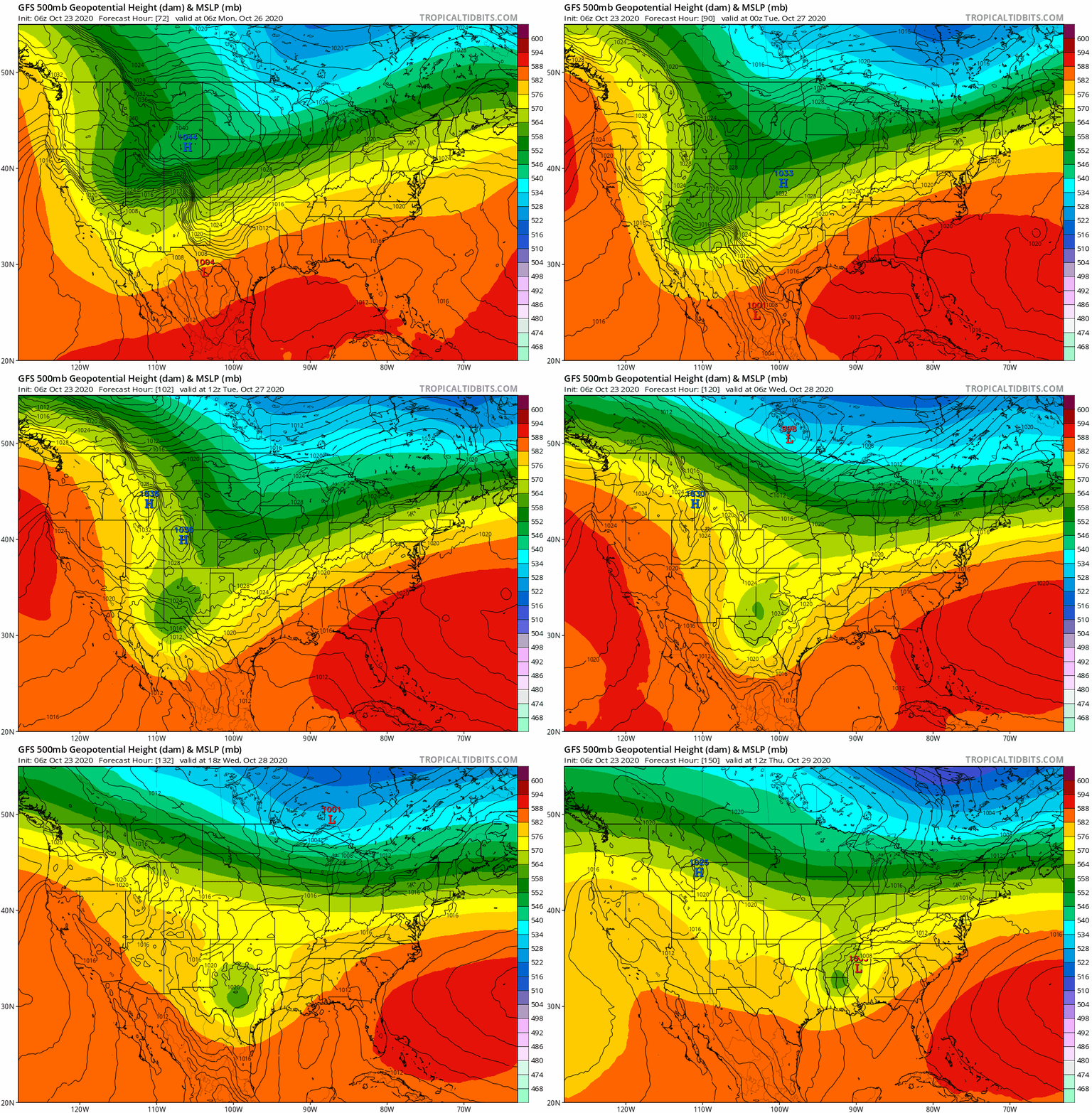
Looks like a weakness opens up over the Florida peninsula before a ridge builds back in 78 hours. So if 95l deepens more quickly, one would think it gets pulled more north:


0 likes
- Ivanhater
- Storm2k Moderator

- Posts: 11221
- Age: 39
- Joined: Fri Jul 01, 2005 8:25 am
- Location: Pensacola
Re: ATL: INVEST 95L - Models
Another northern gulf coast storm? 

Sent from my LM-G900TM using Tapatalk

Sent from my LM-G900TM using Tapatalk
0 likes
Michael
Re: ATL: INVEST 95L - Models
6Z EPS: most active yet with ~20% with a TC: watch out N Gulf coast, especially


2 likes
Personal Forecast Disclaimer:
The posts in this forum are NOT official forecasts and should not be used as such. They are just the opinion of the poster and may or may not be backed by sound meteorological data. They are NOT endorsed by any professional institution or storm2k.org. For official information, please refer to the NHC and NWS products.
The posts in this forum are NOT official forecasts and should not be used as such. They are just the opinion of the poster and may or may not be backed by sound meteorological data. They are NOT endorsed by any professional institution or storm2k.org. For official information, please refer to the NHC and NWS products.
Re: ATL: INVEST 95L - Models
Interesting that neither 06z GFS para or HWRF really strengthen it in the GOM. Upper level conditions, dry air, or cooler SSTs....take your pick?
0 likes
Re: ATL: INVEST 95L - Models
6Z EPS rainfall:


0 likes
Personal Forecast Disclaimer:
The posts in this forum are NOT official forecasts and should not be used as such. They are just the opinion of the poster and may or may not be backed by sound meteorological data. They are NOT endorsed by any professional institution or storm2k.org. For official information, please refer to the NHC and NWS products.
The posts in this forum are NOT official forecasts and should not be used as such. They are just the opinion of the poster and may or may not be backed by sound meteorological data. They are NOT endorsed by any professional institution or storm2k.org. For official information, please refer to the NHC and NWS products.
Re: ATL: INVEST 95L - Models
For what it’s worth, the 06z ICON has 95L stall long enough to become a hurricane as it moves into the Gulf in 96-99 hours.
0 likes
Irene '11 Sandy '12 Hermine '16 5/15/2018 Derecho Fay '20 Isaias '20 Elsa '21 Henri '21 Ida '21
I am only a meteorology enthusiast who knows a decent amount about tropical cyclones. Look to the professional mets, the NHC, or your local weather office for the best information.
I am only a meteorology enthusiast who knows a decent amount about tropical cyclones. Look to the professional mets, the NHC, or your local weather office for the best information.
-
Dean4Storms
- S2K Supporter

- Posts: 6358
- Age: 63
- Joined: Sun Aug 31, 2003 1:01 pm
- Location: Miramar Bch. FL
Re: ATL: INVEST 95L - Models
The 00z ECM Ensembles up to 90% chance of Tropical Depression developing.
0 likes
- SFLcane
- S2K Supporter

- Posts: 10281
- Age: 48
- Joined: Sat Jun 05, 2010 1:44 pm
- Location: Lake Worth Florida
-
cp79
Re: ATL: INVEST 95L - Models
Ivanhater wrote:Another northern gulf coast storm?
https://uploads.tapatalk-cdn.com/20201023/c5b5c8dc832c50db7242867754799fc8.jpg
Sent from my LM-G900TM using Tapatalk
That’s good news for Fla. Looks like most of it will be spared again although the panhandle may get hit.
0 likes
- Iceresistance
- Category 5

- Posts: 9574
- Age: 22
- Joined: Sat Oct 10, 2020 9:45 am
- Location: Tecumseh, OK/Norman, OK
Re: ATL: INVEST 95L - Models
cp79 wrote:Ivanhater wrote:Another northern gulf coast storm?
https://uploads.tapatalk-cdn.com/20201023/c5b5c8dc832c50db7242867754799fc8.jpg
Sent from my LM-G900TM using Tapatalk
That’s good news for Fla. Looks like most of it will be spared again although the panhandle may get hit.
Like Michael in 2018
0 likes
Bill 2015 & Beta 2020
Winter 2020-2021
All observations are in Tecumseh, OK unless otherwise noted.
Winter posts are focused mainly for Oklahoma & Texas.
Take any of my forecasts with a grain of salt, refer to the NWS, SPC, and NHC for official information
Never say Never with weather! Because ANYTHING is possible!
Winter 2020-2021

All observations are in Tecumseh, OK unless otherwise noted.
Winter posts are focused mainly for Oklahoma & Texas.
Take any of my forecasts with a grain of salt, refer to the NWS, SPC, and NHC for official information
Never say Never with weather! Because ANYTHING is possible!
- Iceresistance
- Category 5

- Posts: 9574
- Age: 22
- Joined: Sat Oct 10, 2020 9:45 am
- Location: Tecumseh, OK/Norman, OK
Re: ATL: INVEST 95L - Models
gatorcane wrote:Looks like a weakness opens up over the Florida peninsula before a ridge builds back in 78 hours. So if 95l deepens more quickly, one would think it gets pulled more north:
https://i.postimg.cc/mr86bpLF/gfs-z500a-Norm-watl-fh0-78.gif
The Trough might force the system north or northeast like the NHC suggested.
0 likes
Bill 2015 & Beta 2020
Winter 2020-2021
All observations are in Tecumseh, OK unless otherwise noted.
Winter posts are focused mainly for Oklahoma & Texas.
Take any of my forecasts with a grain of salt, refer to the NWS, SPC, and NHC for official information
Never say Never with weather! Because ANYTHING is possible!
Winter 2020-2021

All observations are in Tecumseh, OK unless otherwise noted.
Winter posts are focused mainly for Oklahoma & Texas.
Take any of my forecasts with a grain of salt, refer to the NWS, SPC, and NHC for official information
Never say Never with weather! Because ANYTHING is possible!
-
plasticup
Re: ATL: INVEST 95L - Models
Huge model spread. I wonder if they'll send recon to get better data.
0 likes
- Iceresistance
- Category 5

- Posts: 9574
- Age: 22
- Joined: Sat Oct 10, 2020 9:45 am
- Location: Tecumseh, OK/Norman, OK
Re: ATL: INVEST 95L - Models
plasticup wrote:Huge model spread. I wonder if they'll send recon to get better data.
The center of circulation is rather broad.
0 likes
Bill 2015 & Beta 2020
Winter 2020-2021
All observations are in Tecumseh, OK unless otherwise noted.
Winter posts are focused mainly for Oklahoma & Texas.
Take any of my forecasts with a grain of salt, refer to the NWS, SPC, and NHC for official information
Never say Never with weather! Because ANYTHING is possible!
Winter 2020-2021

All observations are in Tecumseh, OK unless otherwise noted.
Winter posts are focused mainly for Oklahoma & Texas.
Take any of my forecasts with a grain of salt, refer to the NWS, SPC, and NHC for official information
Never say Never with weather! Because ANYTHING is possible!
- gatorcane
- S2K Supporter

- Posts: 23708
- Age: 48
- Joined: Sun Mar 13, 2005 3:54 pm
- Location: Boca Raton, FL
Re: ATL: INVEST 95L - Models
Another look at the short wave over the Rockies the GFS moves quickly east. My hunch is that this system will be an Eastern Gulf threat and not a northern Gulf threat. Climo suggests that also.


Last edited by gatorcane on Fri Oct 23, 2020 9:30 am, edited 1 time in total.
2 likes
- Evil Jeremy
- S2K Supporter

- Posts: 5463
- Age: 32
- Joined: Mon Apr 10, 2006 2:10 pm
- Location: Los Angeles, CA
Re: ATL: INVEST 95L - Models
gatorcane wrote:My hunch is that this system will be an Eastern Gulf threat and not a panhandle or northern Gulf threat.
Aka Florida west coast?
1 likes
Frances 04 / Jeanne 04 / Katrina 05 / Wilma 05 / Fay 08 / Debby 12 / Andrea 13 / Colin 16 / Hermine 16 / Matthew 16 / Irma 17
-
TheStormExpert
Re: ATL: INVEST 95L - Models
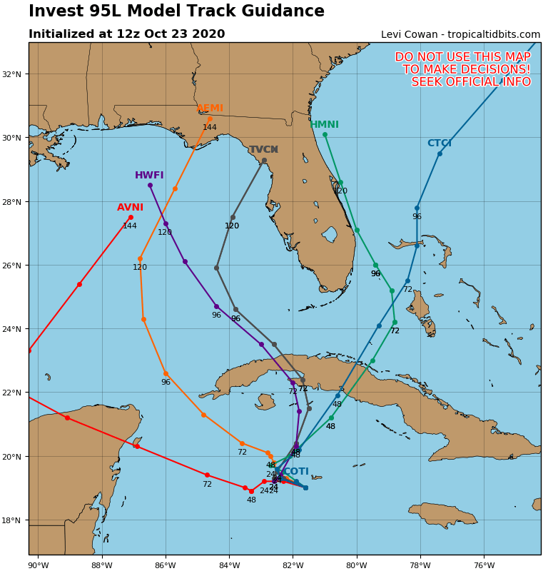
gatorcane wrote:SFLcane wrote:12z models swinging eastward quite a bit.
https://i.postimg.cc/c4nPNNvK/95-L-tracks-12z.png
Quite a consensus!
Just throw a dart at the map and see where it lands.
1 likes
- MississippiWx
- S2K Supporter

- Posts: 1720
- Joined: Sat Aug 14, 2010 1:44 pm
- Location: Hattiesburg, Mississippi
Re: ATL: INVEST 95L - Models
gatorcane wrote:SFLcane wrote:12z models swinging eastward quite a bit.
https://i.postimg.cc/c4nPNNvK/95-L-tracks-12z.png
Looks like they've got it under control.
0 likes
This post is not an official forecast and should not be used as such. It is just the opinion of MississippiWx and may or may not be backed by sound meteorological data. It is not endorsed by any professional institution including storm2k.org. For Official Information please refer to the NHC and NWS products.
- northjaxpro
- S2K Supporter

- Posts: 8900
- Joined: Mon Sep 27, 2010 11:21 am
- Location: Jacksonville, FL
Re: ATL: INVEST 95L - Models
The 00Z EURO ensembles are a bit slower in progression of the shortwave trough ejecting from the Rockies into the Southern Plains next week.
GFS is more progressive. This shortwave definitely holds the key on what eventually unfolds with 95L/ potential Zeta next week.
The 12Z EURO package will be interesting, along with the 12Z UKMET.
GFS is more progressive. This shortwave definitely holds the key on what eventually unfolds with 95L/ potential Zeta next week.
The 12Z EURO package will be interesting, along with the 12Z UKMET.
0 likes
NEVER, EVER SAY NEVER in the tropics and weather in general, and most importantly, with life itself!!
________________________________________________________________________________________
Fay 2008 Beryl 2012 Debby 2012 Colin 2016 Hermine 2016 Julia 2016 Matthew 2016 Irma 2017 Dorian 2019
________________________________________________________________________________________
Fay 2008 Beryl 2012 Debby 2012 Colin 2016 Hermine 2016 Julia 2016 Matthew 2016 Irma 2017 Dorian 2019
Who is online
Users browsing this forum: No registered users and 37 guests


