

ATL: LAURA - Models
Moderator: S2k Moderators
Re: ATL: LAURA - Models
HMON for Laura
0 likes
Personal Forecast Disclaimer:
The posts in this forum are NOT official forecast and should not be used as such. They are just the opinion of the poster and may or may not be backed by sound meteorological data. They are NOT endorsed by any professional institution or storm2k.org. For official information, please refer to the NHC and NWS products.
The posts in this forum are NOT official forecast and should not be used as such. They are just the opinion of the poster and may or may not be backed by sound meteorological data. They are NOT endorsed by any professional institution or storm2k.org. For official information, please refer to the NHC and NWS products.


Re: ATL: LAURA - Models

That would pack a punch. Small(ish) C4 coming in like a bullet. While there's definitely Katrina vibes, I think the Last Island Storm of 1856 may be a more applicable analog given track, size, and intensity for this run.

Last edited by Beef Stew on Sat Aug 22, 2020 12:51 pm, edited 1 time in total.
0 likes

Re: ATL: LAURA - Models
Even with all that land interaction, 12z HMON still gets Laura to a 950 mbar hurricane before landfall at the Tex/Mex border.

0 likes
-
supercane4867
- Category 5

- Posts: 4966
- Joined: Wed Nov 14, 2012 10:43 am
Re: ATL: LAURA - Models
The only reason HMON sends Laura into southern TX is that it weakens Marco rapidly in the northern Gulf thus allowing ridge to build up.
0 likes
-
Frank P
- S2K Supporter

- Posts: 2779
- Joined: Fri Aug 29, 2003 10:52 am
- Location: Biloxi Beach, Ms
- Contact:
Re: ATL: LAURA - Models
Frank P wrote:bella_may wrote:Eerily similar to Katrina
Yeah but no where near the size! And hopefully it doesn’t go thru any ERCs during it journey across the GOM!
But if this comes to fruition it’s a really bad scenario for NOLA coming in at that angle, and most likely the winds will be stronger from this system than Katrina for SELA... IMO
1 likes

Re: ATL: LAURA - Models
supercane4867 wrote:
The only reason HMON sends Laura into southern TX is that it weakens Marco rapidly in the northern Gulf thus allowing ridge to build up.
It's still such a massive spread in these models. From Tex/Mex to the Florida Panhandle. Marco, as everyone has been saying for days now, will definitely be the key to Laura's track as well.
1 likes
Personal Forecast Disclaimer:
The posts in this forum are NOT official forecast and should not be used as such. They are just the opinion of the poster and may or may not be backed by sound meteorological data. They are NOT endorsed by any professional institution or storm2k.org. For official information, please refer to the NHC and NWS products.
The posts in this forum are NOT official forecast and should not be used as such. They are just the opinion of the poster and may or may not be backed by sound meteorological data. They are NOT endorsed by any professional institution or storm2k.org. For official information, please refer to the NHC and NWS products.
-
CrazyC83
- Professional-Met

- Posts: 34311
- Joined: Tue Mar 07, 2006 11:57 pm
- Location: Deep South, for the first time!
Re: ATL: LAURA - Models
Basically, the spread is from a Beulah repeat to a Betsy repeat. That's an enormous difference.
0 likes
-
tolakram
- Admin

- Posts: 20174
- Age: 62
- Joined: Sun Aug 27, 2006 8:23 pm
- Location: Florence, KY (name is Mark)
Re: ATL: LAURA - Models
HWRF 12Z run.
HWRF loves to keep intensifying storms near the end of it's run so I would not be overly concerned about strength at the moment, but something to look out for. IMO

HWRF loves to keep intensifying storms near the end of it's run so I would not be overly concerned about strength at the moment, but something to look out for. IMO
0 likes
M a r k
- - - - -
Join us in chat: Storm2K Chatroom Invite. Android and IOS apps also available.
The posts in this forum are NOT official forecasts and should not be used as such. Posts are NOT endorsed by any professional institution or STORM2K.org. For official information and forecasts, please refer to NHC and NWS products.

Re: ATL: LAURA - Models
We're in extreme southern Mississippi about 10 miles from Biloxi, 50 miles from Mobile, and we have NO idea what to do. I'm pulling out my hair.
1 likes

Re: ATL: LAURA - Models
I’ve told my family in Mississippi to rush any outdoor stuff to completion tomorrow before Marco. They will stay put til Tuesday as I’m not too concerned about surge with Marco, at this point.
More concerned with Laura for sure. They will need to evacuate if it starts to look like a major coming in near the mouth of the ms. If today’s shift toward grand isle and west holds will feel better about them staying put. But they have a couple days to watch. If it comes any any further East they’ll have to get out. Lots to watch.
More concerned with Laura for sure. They will need to evacuate if it starts to look like a major coming in near the mouth of the ms. If today’s shift toward grand isle and west holds will feel better about them staying put. But they have a couple days to watch. If it comes any any further East they’ll have to get out. Lots to watch.
Last edited by PTPatrick on Sat Aug 22, 2020 1:04 pm, edited 1 time in total.
2 likes

Re: ATL: LAURA - Models
12Z Euro now has Laura as a strong tropical storm in the Florida Straits... big difference from last run
0 likes
-
SFLcane

- S2K Supporter
- Posts: 10281
- Age: 48
- Joined: Sat Jun 05, 2010 1:44 pm
- Location: Lake Worth Florida
Re: ATL: LAURA - Models
You can see HWRF correcting itself. 12z basically rides along Cuba coast.
0 likes
-
gatorcane

- S2K Supporter
- Posts: 23708
- Age: 48
- Joined: Sun Mar 13, 2005 3:54 pm
- Location: Boca Raton, FL
Re: ATL: LAURA - Models
12 Euro at 72 hours, definitely stronger. But how does it strengthen with all the land interaction especially between 24 and 48 hours? Seems unlikely. Conditions are favorable in the Gulf but I would be cautious looking at each of these runs until we see how Laura interacts with Hispaniola and Cuba which have some very tall mountains that have been known to shred cyclones apart. I imagine it is tough to model something like that:
0 likes
-
DestinHurricane

- Category 4

- Posts: 935
- Joined: Tue May 01, 2018 8:05 am
- Location: New York, NY
Re: ATL: LAURA - Models
SFLcane wrote:You can see HWRF correcting itself. 12z basically rides along Cuba coast.
Probably will shift back east once it initializes the right center N of PR.
0 likes
Michael 2018

Re: ATL: LAURA - Models
That is a pretty big shift north. The keys need to watch out. 
Last edited by blp on Sat Aug 22, 2020 1:17 pm, edited 1 time in total.
1 likes
The following post is NOT an official forecast and should not be used as such. It is just the opinion of the poster and may or may not be backed by sound meteorological data. It is NOT endorsed by any professional institution including storm2k.org For Official Information please refer to the NHC and NWS products.
-
gatorcane
- S2K Supporter
- Posts: 23708
- Age: 48
- Joined: Sun Mar 13, 2005 3:54 pm
- Location: Boca Raton, FL
Re: ATL: LAURA - Models
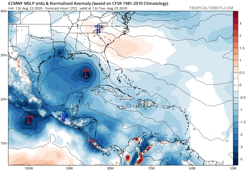
gatorcane wrote:12 Euro at 72 hours, definitely stronger. But how does it strengthen with all the land interaction especially between 24 and 48 hours? Seems unlikely. Conditions are favorable in the Gulf but I would be cautious looking at each of these runs until we see how Laura interacts with Hispaniola and Cuba which have some very tall mountains that have been known to shred cyclones apart. I imagine it is tough to model something like that:
https://i.postimg.cc/28mLM0Ct/ecmwf-mslpa-Norm-watl-4.png
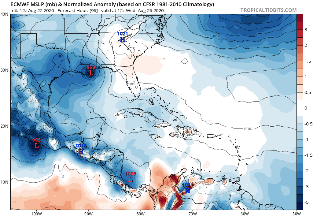
Following on to this, some potentially good news in that the 96 hour Euro forecast weakens Laura on the approach to the northern Gulf. Goes from 993MB at 72 hours to 999MB at 96 hours. I say potential because we need to see if other models start picking up on whatever the Euro is seeing that causes the weakening:
Last edited by gatorcane on Sat Aug 22, 2020 1:20 pm, edited 3 times in total.
0 likes


-
Nederlander
- S2K Supporter
- Posts: 1259
- Joined: Sat Jul 19, 2008 4:28 pm
- Location: Conroe, TX
Re: ATL: LAURA - Models
Not a good trend for SE LA.. Double hit on Plaquemines in the 12z euro
1 likes
Who is online
Users browsing this forum: No registered users and 25 guests