ATL: LAURA - Models
Moderator: S2k Moderators
-
cp79
Re: ATL: LAURA - Models
Damn Euro has it trucking. Not sure this thing will ever get past cat 2 strength with it moving so fast.
0 likes

Re: ATL: LAURA - Models
Euro at 96 looks dead on maybe a hair East of hwrf. Now have a spread from closer to vermilion bay with gfs and NOLA with The Euro. Feeling like some concensus building here. Obviously still lots of time and I still think anywhere in northern gulf is not out of the question but It starting to feel like these swings will be fewer and smaller. And we wait...
1 likes
-
eastcoastFL

- Category 5

- Posts: 3996
- Age: 44
- Joined: Thu Apr 12, 2007 12:29 pm
- Location: Palm City, FL
Re: ATL: LAURA - Models
Euro similar track as HWRF but waaay faster and weaker

0 likes
Personal Forecast Disclaimer:
The posts in this forum are NOT official forecast and should not be used as such. They are just the opinion of the poster and may or may not be backed by sound meteorological data. They are NOT endorsed by any professional institution or storm2k.org. For official information, please refer to the NHC and NWS products.
The posts in this forum are NOT official forecast and should not be used as such. They are just the opinion of the poster and may or may not be backed by sound meteorological data. They are NOT endorsed by any professional institution or storm2k.org. For official information, please refer to the NHC and NWS products.
Re: ATL: LAURA - Models
Yep that tells me speed will be key. If it’s goes faster than seems like ms coast could be in more trouble...slower and you are looking closer to Morgan city,
0 likes
-
MississippiWx

- S2K Supporter

- Posts: 1720
- Joined: Sat Aug 14, 2010 1:44 pm
- Location: Hattiesburg, Mississippi
Re: ATL: LAURA - Models
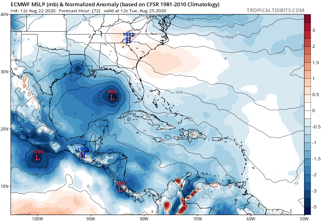
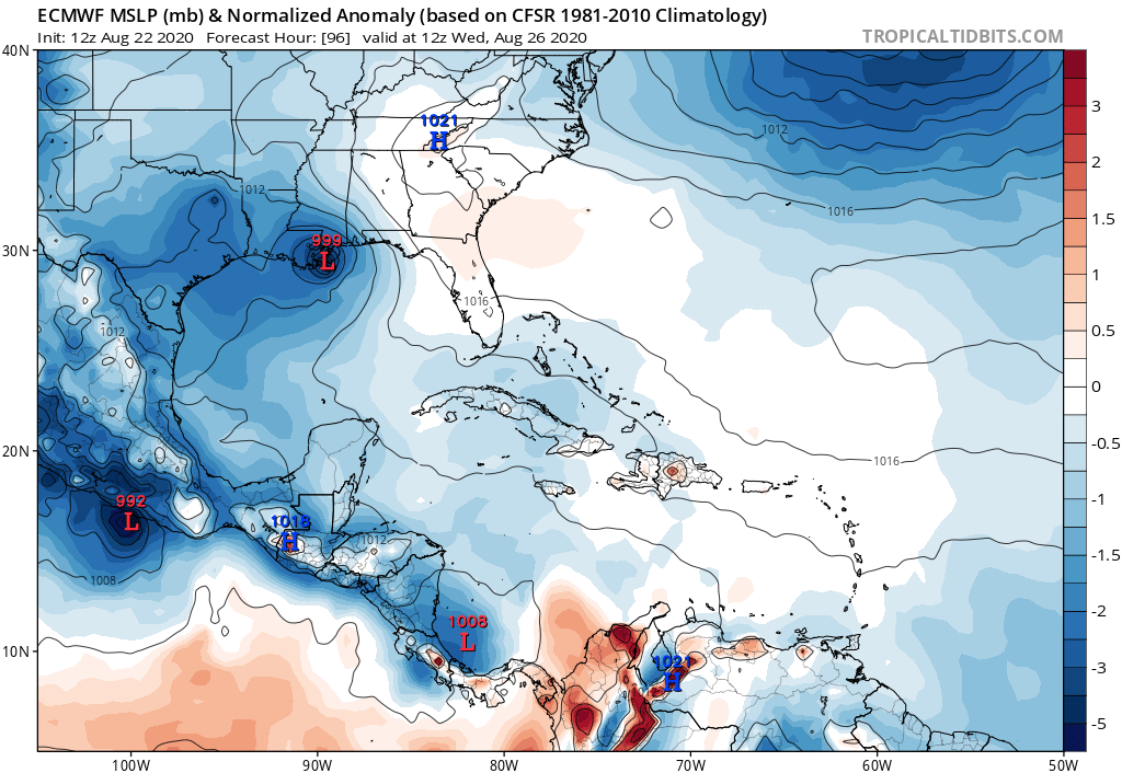
gatorcane wrote:gatorcane wrote:12 Euro at 72 hours, definitely stronger. But how does it strengthen with all the land interaction especially between 24 and 48 hours? Seems unlikely. Conditions are favorable in the Gulf but I would be cautious looking at each of these runs until we see how Laura interacts with Hispaniola and Cuba which have some very tall mountains that have been known to shred cyclones apart. I imagine it is tough to model something like that:
https://i.postimg.cc/28mLM0Ct/ecmwf-mslpa-Norm-watl-4.png
Following on to this, some potentially good news in that the 96 hour Euro forecast weakens Laura on the approach to the northern Gulf. Goes from 993MB at 72 hours to 999MB at 96 hours. I say potential because we need to see if other models stars picking up on whatever the Euro is seeing that causes the weakening:
https://i.postimg.cc/X7z3dv1g/ecmwf-mslpa-Norm-watl-5.png
You just said to be cautious looking at a 24-48 hour forecast and then highlight potential good news at 96 hours. The storm is inland at that point, thus a weaker look.
The conditions in the Gulf will be ripe. The biggest question is what structure does it have after island interaction.
2 likes
This post is not an official forecast and should not be used as such. It is just the opinion of MississippiWx and may or may not be backed by sound meteorological data. It is not endorsed by any professional institution including storm2k.org. For Official Information please refer to the NHC and NWS products.
-
cheezyWXguy

- Category 5
- Posts: 6280
- Joined: Mon Feb 13, 2006 12:29 am
- Location: Dallas, TX
Re: ATL: LAURA - Models
eastcoastFL wrote:Euro similar track as HWRF but waaay faster and weaker
https://www.tropicaltidbits.com/analysis/models/ecmwf/2020082212/ecmwf_mslp_uv850_watl_5.png
If the core is not significantly disrupted by land I have a hard time seeing how this stays below hurricane strength. Conditions look ripe in the gulf, even if it does move that fast. Probably wouldn’t get to cat 4 though.
3 likes
-
eastcoastFL
- Category 5
- Posts: 3996
- Age: 44
- Joined: Thu Apr 12, 2007 12:29 pm
- Location: Palm City, FL
Re: ATL: LAURA - Models
PTPatrick wrote:Yep that tells me speed will be key. If it’s goes faster than seems like ms coast could be in more trouble...slower and you are looking closer to Morgan city,
Why is it so fast though? No other models show that speed, I wonder if it has to do with Marco and the ridge building in behind it
0 likes
Personal Forecast Disclaimer:
The posts in this forum are NOT official forecast and should not be used as such. They are just the opinion of the poster and may or may not be backed by sound meteorological data. They are NOT endorsed by any professional institution or storm2k.org. For official information, please refer to the NHC and NWS products.
The posts in this forum are NOT official forecast and should not be used as such. They are just the opinion of the poster and may or may not be backed by sound meteorological data. They are NOT endorsed by any professional institution or storm2k.org. For official information, please refer to the NHC and NWS products.
-
gatorcane

- S2K Supporter
- Posts: 23708
- Age: 48
- Joined: Sun Mar 13, 2005 3:54 pm
- Location: Boca Raton, FL
Re: ATL: LAURA - Models
Notice the GFS ensembles which keep Laura on the weak side. The Euro is landfalling at 999MB so not too far off. Just don’t even look at the HWRF beyond 3 days. I am still waiting on the CAT 5 it showed for me just a couple of days ago 
Last edited by gatorcane on Sat Aug 22, 2020 1:25 pm, edited 1 time in total.
5 likes
-
MississippiWx
- S2K Supporter
- Posts: 1720
- Joined: Sat Aug 14, 2010 1:44 pm
- Location: Hattiesburg, Mississippi
Re: ATL: LAURA - Models
eastcoastFL wrote:Euro similar track as HWRF but waaay faster and weaker
https://www.tropicaltidbits.com/analysis/models/ecmwf/2020082212/ecmwf_mslp_uv850_watl_5.png
The euro has it in almost the same spot as HWRF, just 3-6 hours earlier. Not a huge difference for a 4 day forecast.
0 likes
This post is not an official forecast and should not be used as such. It is just the opinion of MississippiWx and may or may not be backed by sound meteorological data. It is not endorsed by any professional institution including storm2k.org. For Official Information please refer to the NHC and NWS products.

Re: ATL: LAURA - Models
12z GFS ensembles now have a few members hugging the west coast of Fl. Be watching carefully next.few days. This is gonna be close with the strength and orientation of ridge the key to Laura's eventual track in the eastern GOM.
4 likes
Re: ATL: LAURA - Models
The next 24 hours will be crucial. Anything from a low end cat 1 to a low end cat 4 is possible
0 likes
-
Ivanhater

- Storm2k Moderator

- Posts: 11221
- Age: 39
- Joined: Fri Jul 01, 2005 8:25 am
- Location: Pensacola
Re: ATL: LAURA - Models
Notice the 12z euro brings it nne from Nola. A sign the ridge is weaker
Sent from my SM-G955U using Tapatalk
Sent from my SM-G955U using Tapatalk
4 likes
Michael
Re: ATL: LAURA - Models
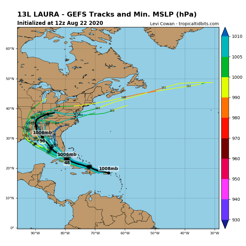
gatorcane wrote:Notice the GFS ensembles which keep Laura on the weak side. The Euro is landfalling at 999MB so not too far off. Just don’t even look at the HWRF beyond 3 days. I am still waiting on the CAT 5 it showed for me just a couple of days ago
https://i.postimg.cc/KYcdWSWY/13-L-gefs-12z.png
Glad you posted that. I was telling my brother I wasn’t as concerned about strength yet as the Hwrf is better at track. I do think conditions look favorable but that model loves to make a cat 5 out of anything. If it’s still showing a major this time tomorrow I will be more concerned.
0 likes

-
DestinHurricane

- Category 4

- Posts: 935
- Joined: Tue May 01, 2018 8:05 am
- Location: New York, NY
Re: ATL: LAURA - Models
crimi481 wrote:We can say models trending east?
For sure. GFS and Euro have both shifted east. TVCN will go east.
3 likes
Michael 2018
-
AtlanticWind

- S2K Supporter
- Posts: 1898
- Age: 67
- Joined: Sun Aug 08, 2004 9:57 pm
- Location: Plantation,Fla
Re: ATL: LAURA - Models
Cant really use the Euro for intensity, just the fact that is now depicting a organised system approaching the
Gulf coast is cause for concern.
Gulf coast is cause for concern.
5 likes

Re: ATL: LAURA - Models
gatorcane wrote:Notice the GFS ensembles which keep Laura on the weak side. The Euro is landfalling at 999MB so not too far off. Just don’t even look at the HWRF beyond 3 days. I am still waiting on the CAT 5 it showed for me just a couple of days ago
https://i.postimg.cc/KYcdWSWY/13-L-gefs-12z.png
Gator you are almost trolling at this point. I have seen you on here for a while and have not seen this from you before until this season. I don't know what up? We all know the HWRF overdoes the intensity and nobody that has been here for a while takes it as gospel. It has done a decent job on the evolution of the track for this system. At least it showed something unlike the Euro and GFS.
My concern is we cannot just downplay this because the reliable models plow this over land. if it does follow the northerly path lots of places are in for some trouble and may get caught off guard.
17 likes
The following post is NOT an official forecast and should not be used as such. It is just the opinion of the poster and may or may not be backed by sound meteorological data. It is NOT endorsed by any professional institution including storm2k.org For Official Information please refer to the NHC and NWS products.
-
LowerAlabamaTider

- Tropical Storm

- Posts: 111
- Age: 66
- Joined: Thu Aug 20, 2020 1:08 pm
Re: ATL: LAURA - Models
These recent runs not so comforting for us along Alabama coast either.
0 likes
-
cp79
Re: ATL: LAURA - Models
crimi481 wrote:We can say models trending east?
Not significantly though. HWRF actually moved more West. But the consensus was the La/Tx coast and now it’s more around NO.
0 likes
Who is online
Users browsing this forum: No registered users and 4 guests