
Sent from my SM-G955U using Tapatalk
Moderator: S2k Moderators


blp wrote:gatorcane wrote:Notice the GFS ensembles which keep Laura on the weak side. The Euro is landfalling at 999MB so not too far off. Just don’t even look at the HWRF beyond 3 days. I am still waiting on the CAT 5 it showed for me just a couple of days ago
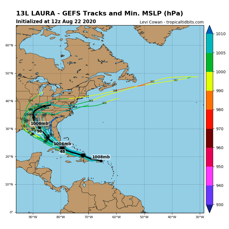
https://i.postimg.cc/KYcdWSWY/13-L-gefs-12z.png
Gator you are almost trolling at this point. I have seen you on here for a while and have not seen this from you before until this season. I don't know what up? We all know the HWRF overdoes the intensity and nobody that has been here for a while takes it as gospel. It has done a decent job on the evolution of the track for this system. At least it showed something unlike the Euro and GFS.
My concern is we cannot just downplay this because the reliable models plow this over land. if it does follow the northerly path lots of places are in for some trouble and may get caught off guard.


DestinHurricane wrote:crimi481 wrote:We can say models trending east?
For sure. GFS and Euro have both shifted east. TVCN will go east.
CrazyC83 wrote:Could this be a case where stronger = west and weaker = east due to variance in upper-level flows? In other words, could the low-level steering try to send it into MS or AL, but the deep-layer steering try to parallel the LA coast?


Michele B wrote:DestinHurricane wrote:crimi481 wrote:We can say models trending east?
For sure. GFS and Euro have both shifted east. TVCN will go east.
Shifting east makes me think of Charley....going to Tampa....donch'a know?
Except it ended up going right over MY HOUSE!!!!!


cp79 wrote:Michele B wrote:DestinHurricane wrote:For sure. GFS and Euro have both shifted east. TVCN will go east.
Shifting east makes me think of Charley....going to Tampa....donch'a know?
Except it ended up going right over MY HOUSE!!!!!
You can thank Bonnie for that. It nudged it left. That's why I wonder if Marco could nudge Laura left like it did that storm. Not drastically, but just enough that could make the difference between New Orleans and Pensacola.

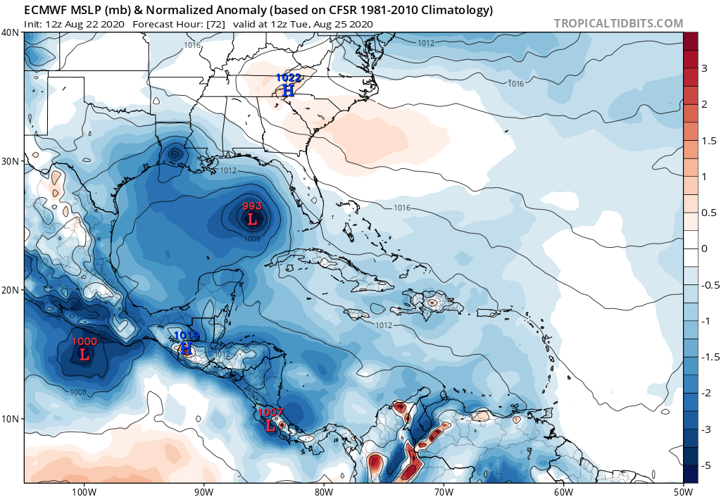
MississippiWx wrote:gatorcane wrote:gatorcane wrote:12 Euro at 72 hours, definitely stronger. But how does it strengthen with all the land interaction especially between 24 and 48 hours? Seems unlikely. Conditions are favorable in the Gulf but I would be cautious looking at each of these runs until we see how Laura interacts with Hispaniola and Cuba which have some very tall mountains that have been known to shred cyclones apart. I imagine it is tough to model something like that:
https://i.postimg.cc/28mLM0Ct/ecmwf-mslpa-Norm-watl-4.png
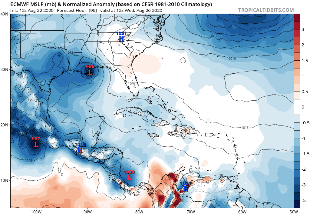
Following on to this, some potentially good news in that the 96 hour Euro forecast weakens Laura on the approach to the northern Gulf. Goes from 993MB at 72 hours to 999MB at 96 hours. I say potential because we need to see if other models stars picking up on whatever the Euro is seeing that causes the weakening:
https://i.postimg.cc/X7z3dv1g/ecmwf-mslpa-Norm-watl-5.png
You just said to be cautious looking at a 24-48 hour forecast and then highlight potential good news at 96 hours. The storm is inland at that point, thus a weaker look.
The conditions in the Gulf will be ripe. The biggest question is what structure does it have after island interaction.
eastcoastFL wrote:MississippiWx wrote:gatorcane wrote:
Following on to this, some potentially good news in that the 96 hour Euro forecast weakens Laura on the approach to the northern Gulf. Goes from 993MB at 72 hours to 999MB at 96 hours. I say potential because we need to see if other models stars picking up on whatever the Euro is seeing that causes the weakening:
https://i.postimg.cc/X7z3dv1g/ecmwf-mslpa-Norm-watl-5.png
You just said to be cautious looking at a 24-48 hour forecast and then highlight potential good news at 96 hours. The storm is inland at that point, thus a weaker look.
The conditions in the Gulf will be ripe. The biggest question is what structure does it have after island interaction.
I think the euro was weaker this run because it sling shots the thing across the gulf. But even if it’s moving quick it would be surprising if it didn’t undergo strengthening in the gulf.

Kingarabian wrote:12z EPS:
https://i.imgur.com/uCS7yNv.png

1900hurricane wrote:Yeah, noticeable correlation between track and intensity with EPS members. Definitely deserves a closer look.
Kingarabian wrote:12z EPS:
https://i.imgur.com/uCS7yNv.png
Users browsing this forum: No registered users and 13 guests


