ATL: ETA - Post-Tropical - Discussion
Moderator: S2k Moderators


Re: ATL: ETA - Hurricane - Discussion
Forecast to attain Category 5 status at 7:00 AM EST. Although clouds tops are starting to look warmer on infrared. I think this was no double a 160 mph+ hurricane earlier tonight.
0 likes

Re: ATL: ETA - Hurricane - Discussion: 7 PM EST = 150 mph
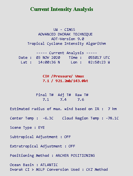
UW - CIMSS
ADVANCED DVORAK TECHNIQUE
ADT-Version 9.0
Tropical Cyclone Intensity Algorithm
----- Current Analysis -----
Date : 03 NOV 2020 Time : 052017 UTC
Lat : 14:00:00 N Lon : 82:49:48 W
CI# /Pressure/ Vmax
6.9 / 926.4mb/137.4kt
Final T# Adj T# Raw T#
6.9 7.3 7.8
Estimated radius of max. wind based on IR : 7 km
Center Temp : -3.0C Cloud Region Temp : -78.6C
Scene Type : EYE
Subtropical Adjustment : OFF
Extratropical Adjustment : OFF
Positioning Method : ARCHER POSITIONING
Up to 6.9, Adjusted is 7.3, Raw drops to 7.8
0 likes
Re: ATL: ETA - Hurricane - Discussion
I'm thinking it may remain a high end Category 4...with the cyclone nearing landfall...and the high terrain....but it will be close...
0 likes
Re: ATL: ETA - Hurricane - Discussion
Can't fault recon - they don't want to fly into a Cat 4 or 5 at night with faulty equipment. I think the Hugo experience in 1989 left it's mark, when NOAA 43 (or was it 42) almost went down after losing 2 engines in the eye - and that was in the middle of the day.
The other issue is both NOAA and DoD have used up a lot of flight hours this year. Fiscal FY-21 began on October 1 so the current very active season is now taking funds from next seasons flight hours.
Still, above all it's safety first...
Frank
The other issue is both NOAA and DoD have used up a lot of flight hours this year. Fiscal FY-21 began on October 1 so the current very active season is now taking funds from next seasons flight hours.
Still, above all it's safety first...
Frank
4 likes
-
Extratropical94

- Professional-Met

- Posts: 3545
- Age: 31
- Joined: Wed Oct 20, 2010 6:36 am
- Location: Hamburg, Germany
- Contact:
Re: ATL: ETA - Hurricane - Discussion
It's becoming less likely that we'll see 140 kts at 4am EST.
TXNT22 KNES 030542
TCSNTL
A. 29L (ETA)
B. 03/0530Z
C. 14.0N
D. 82.8W
E. ONE/GOES-E
F. T6.5/6.5
G. IR/EIR/SWIR
H. REMARKS...OW EYE SURROUNDED BY CMG AND EMBEDDED IN WHITE YIELDS A DT
OF 6.5 AFTER AN EYE ADJUSTMENT OF +0.5. MET IS EQUAL TO 5.5 AND PT IS
EQUAL TO 6.0 BASED ON RAPID DEVELOPMENT TREND IN LAST 24H. FT IS BASED
ON DT.
I. ADDL POSITIONS
NIL
...TUGGLE
0 likes
54° 11' 59'' N, 9° 9' 20'' E
Boomer Sooner!
Go Broncos! Go Cards!
Clinching counties, one at a time: https://mob-rule.com/user-gifs/USA/xtrp94.gif
- Daniel
Boomer Sooner!
Go Broncos! Go Cards!
Clinching counties, one at a time: https://mob-rule.com/user-gifs/USA/xtrp94.gif
- Daniel
-
skyline385

- Category 5

- Posts: 2728
- Age: 35
- Joined: Wed Aug 26, 2020 11:15 pm
- Location: Houston TX
Re: ATL: ETA - Hurricane - Discussion
On another note, the latest GFS has Eta headed towards LA
1 likes
Re: ATL: ETA - Hurricane - Discussion
skyline385 wrote:On another note, the latest GFS has Eta headed towards LA
Perish the thought....
0 likes
-
euro6208
Re: ATL: ETA - Hurricane - Discussion
TyphoonNara wrote:Hayabusa wrote:Wow I don't really watch hurricanes unless they are really strong and this one got raw 8s and above on multiple fixes
If this was in the WPAC the highest delta here would be probably give about a raw of 7.7.2020NOV03 005017 6.2 942.1 119.8 6.2 6.3 8.1 1.3T/6hr OFF OFF OFF OFF -6.22 -80.40 EYE 7 IR 20.0 14.22 82.52 ARCHER GOES16 18.7
2020NOV03 012017 6.3 940.0 122.2 6.3 6.4 8.2 1.3T/6hr OFF OFF OFF OFF -9.20 -81.43 EYE 7 IR 20.0 14.19 82.54 ARCHER GOES16 18.7
2020NOV03 015017 6.3 940.0 122.2 6.3 6.3 8.3 1.3T/6hr OFF OFF OFF OFF -9.98 -81.80 EYE 7 IR 20.0 14.17 82.56 ARCHER GOES16 18.7
2020NOV03 022017 6.3 940.1 122.2 6.3 6.3 8.4 1.3T/6hr OFF OFF OFF OFF 3.37 -81.52 EYE 7 IR 20.0 14.12 82.60 ARCHER GOES16 18.6
2020NOV03 025017 6.3 940.1 122.2 6.3 6.5 8.4 1.3T/6hr OFF OFF OFF OFF 10.53 -81.37 EYE 8 IR 20.0 14.08 82.61 ARCHER GOES16 18.6
2020NOV03 032017 6.4 938.0 124.6 6.4 6.7 8.4 1.3T/6hr OFF OFF OFF OFF 7.28 -81.52 EYE 8 IR 20.0 14.08 82.65 ARCHER GOES16 18.6
2020NOV03 035017 6.4 938.0 124.6 6.4 6.9 8.3 1.3T/6hr OFF OFF OFF OFF 3.76 -81.05 EYE 8 IR 20.0 14.09 82.68 ARCHER GOES16 18.6
2020NOV03 042017 6.6 933.5 129.6 6.6 7.1 8.3 1.3T/6hr OFF OFF OFF OFF 9.55 -80.20 EYE 8 IR 20.0 14.09 82.71 ARCHER GOES16 18.7
2020NOV03 045018 6.7 931.2 132.2 6.7 7.2 8.1 1.3T/6hr OFF OFF OFF OFF 5.22 -79.46 EYE 7 IR 20.0 14.02 82.77 ARCHER GOES16 18.6
I think ADT have different algorithms for storms in the Eastern and Western hemisphere. I remember seeing storms passing the international date line and then its ADT immediately drops by 0.5. This is questionable in my opinion though.
A rawT# of 7.7 if Eta is in WPac seems about to be right.
That's true. A study was done on this. ADT yields different numbers for the eastern (lower) and western hemisphere (higher) for the same system.
Last edited by euro6208 on Tue Nov 03, 2020 1:40 am, edited 1 time in total.
0 likes
Re: ATL: ETA - Hurricane - Discussion
There will be NO more recon missions before landfall? Storm looks to be waning on infrared satellite.
0 likes
Re: ATL: ETA - Hurricane - Discussion
Category 5 will likely have to wait for post-season...let's see the wind reports from Nicaragua.
0 likes
-
euro6208
Re: ATL: ETA - Hurricane - Discussion
Truly a catastrophic hurricane at landfall no matter what category.
0 likes

Re: ATL: ETA - Hurricane - Discussion
I wonder if that 2nd mission this evening was cancelled due to safety concerns. The last VDM from the last mission that made it into the storm made specific note of "MANY MESOVORTICES ROTATING ON INSIDE EYEWALL."
They have to avoid the mesovortices for safety, because mesovortices can cause an aircraft crisis, as it was considered a good possibility that a meso was responsible for what happened on that fateful Hugo flight.
If you're trying to hit the center of a pinhole eye while avoiding numerous mesovortices rotating around, that seems like a really big risk. Maybe they said it was too risky and cancelled.
0 likes
Solar Aquarian
Lunar Cancerian
 Sagittarian
Lunar Cancerian

Re: ATL: ETA - Hurricane - Discussion
0z Euro with a deep hurricane in the central gulf heading E at the end of the run..
0 likes

Re: ATL: ETA - Hurricane - Discussion
Considering final T# are now up to 7.2 and the fact that the NHC themselves is already forecasting a cat 5 at landfall (and it's rare for them to go below their own forecasts for strong storms), I'm fairly confident that this will be a cat 5 in the next advisory.
Last edited by kevin on Tue Nov 03, 2020 2:08 am, edited 2 times in total.
0 likes
Re: ATL: ETA - Hurricane - Discussion
Even if the NHC wants to play it safe and go slightly below ADT you'd still have a 140 kts cat 5 system.
Current Intensity Analysis
UW - CIMSS
ADVANCED DVORAK TECHNIQUE
ADT-Version 9.0
Tropical Cyclone Intensity Algorithm
----- Current Analysis -----
Date : 03 NOV 2020 Time : 062017 UTC
Lat : 13:58:12 N Lon : 82:54:00 W
CI# /Pressure/ Vmax
7.2 / 919.3mb/146.0kt
Final T# Adj T# Raw T#
7.2 7.5 7.6
UW - CIMSS
ADVANCED DVORAK TECHNIQUE
ADT-Version 9.0
Tropical Cyclone Intensity Algorithm
----- Current Analysis -----
Date : 03 NOV 2020 Time : 062017 UTC
Lat : 13:58:12 N Lon : 82:54:00 W
CI# /Pressure/ Vmax
7.2 / 919.3mb/146.0kt
Final T# Adj T# Raw T#
7.2 7.5 7.6
0 likes
-
skyline385
- Category 5
- Posts: 2728
- Age: 35
- Joined: Wed Aug 26, 2020 11:15 pm
- Location: Houston TX
Re: ATL: ETA - Hurricane - Discussion
Chris90 wrote:I wonder if that 2nd mission this evening was cancelled due to safety concerns. The last VDM from the last mission that made it into the storm made specific note of "MANY MESOVORTICES ROTATING ON INSIDE EYEWALL."
They have to avoid the mesovortices for safety, because mesovortices can cause an aircraft crisis, as it was considered a good possibility that a meso was responsible for what happened on that fateful Hugo flight.
If you're trying to hit the center of a pinhole eye while avoiding numerous mesovortices rotating around, that seems like a really big risk. Maybe they said it was too risky and cancelled.
This is a good point, and to support it look at what happened to AF304's altitude when it made the first pass

0 likes
Who is online
Users browsing this forum: No registered users and 24 guests