ATL: PAULETTE - Remnants - Discussion

Moderator: S2k Moderators

Message
Author
User avatar
aspen
Category 5
Category 5
Posts: 8818
Joined: Sat Oct 12, 2019 7:10 pm
Location: Connecticut, USA

Re: ATL: PAULETTE - Tropical Storm - Discussion

#261 Postby aspen » Sat Sep 12, 2020 7:00 pm

us89 wrote:Dropsonde from the last pass measured a surface pressure of 982 mb with a 10 kt wind - suggesting a 981 mb central pressure.

The NHC went with 981 mbar for the 8pm intermediate advisory. The fact that the pressure is this low for a high-end TS means either Paulette will be a major with a lower than normal pressure, or it’ll have a MH-like pressure but winds will lag behind. I’m hoping for the former (assuming it misses Bermuda) because it’ll mean more ACE.
0 likes   
Irene '11 Sandy '12 Hermine '16 5/15/2018 Derecho Fay '20 Isaias '20 Elsa '21 Henri '21 Ida '21

I am only a meteorology enthusiast who knows a decent amount about tropical cyclones. Look to the professional mets, the NHC, or your local weather office for the best information.

User avatar
gfsperpendicular
Category 1
Category 1
Posts: 383
Age: 21
Joined: Mon Jun 19, 2017 3:04 pm
Location: Northern Virginia

Re: ATL: PAULETTE - Tropical Storm - Discussion

#262 Postby gfsperpendicular » Sat Sep 12, 2020 7:25 pm

I think that with the huge extent of FL hurricane-force winds and the mid-grade cat 1 pressure, the system is intensifying but surface winds are lagging. Maybe Hurricane Paulette is coming soon.
0 likes   
I'm not sleeping, I'm waiting for the 0900 UTC advisory!

#1 CMC stan

ClarCari
Category 2
Category 2
Posts: 579
Joined: Thu Aug 13, 2020 11:02 am

Re: ATL: PAULETTE - Tropical Storm - Discussion

#263 Postby ClarCari » Sat Sep 12, 2020 7:27 pm

What an odd satellite appearance Paulette has had all day.
She has like a sunset look. The infrared looks like setting sun with the rest of the convection looking like pretty rays emanating from the center. Kinda pretty actually.

Too bad we can’t call her Sunset Sally :sun:
2 likes   

us89
Category 1
Category 1
Posts: 399
Joined: Wed Sep 04, 2019 11:12 pm
Location: Tallahassee, FL

Re: ATL: PAULETTE - Tropical Storm - Discussion

#264 Postby us89 » Sat Sep 12, 2020 7:28 pm

Pressure looks to be about 1 mb lower on this pass.
0 likes   

User avatar
aspen
Category 5
Category 5
Posts: 8818
Joined: Sat Oct 12, 2019 7:10 pm
Location: Connecticut, USA

Re: ATL: PAULETTE - Tropical Storm - Discussion

#265 Postby aspen » Sat Sep 12, 2020 7:29 pm

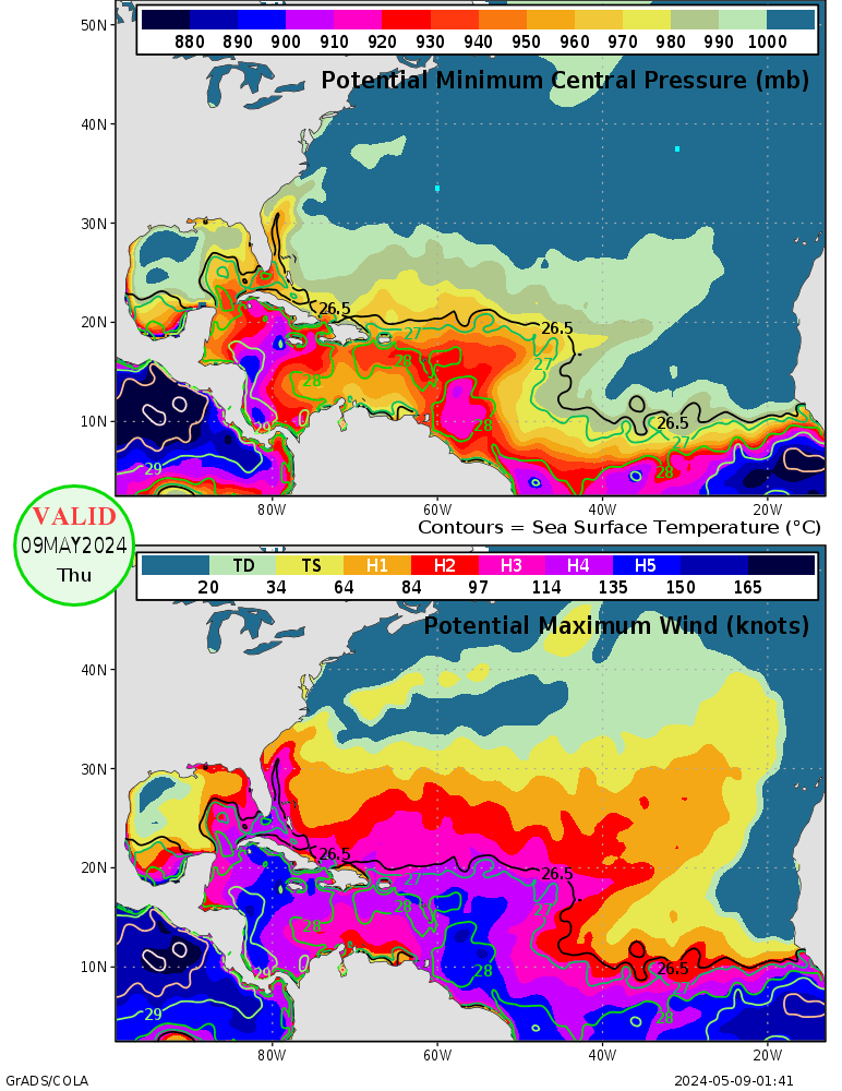
The MPI map shows that the waters Paulette will travel through in the next 48-60 hours are high enough to support a high end Cat 4 or a Cat 5. However, the broad wind field and lagging surface winds (or low background pressure) lead me to believe that a more reasonable maximum potential intensity for Paulette is 9250-940 mbar and 120-130 kt, or a storm very similar to Karl '04 (125 kt and 938 mbar) and Earl '10 (125 kt and 927 mbar).
Image
0 likes   
Irene '11 Sandy '12 Hermine '16 5/15/2018 Derecho Fay '20 Isaias '20 Elsa '21 Henri '21 Ida '21

I am only a meteorology enthusiast who knows a decent amount about tropical cyclones. Look to the professional mets, the NHC, or your local weather office for the best information.

User avatar
cainjamin
Tropical Storm
Tropical Storm
Posts: 168
Age: 34
Joined: Mon Apr 17, 2017 1:38 pm
Location: Nova Scotia, Canada

Re: ATL: PAULETTE - Tropical Storm - Discussion

#266 Postby cainjamin » Sat Sep 12, 2020 7:38 pm

Dropsonde in the SE quad recorded 66kt at the surface. Very close to hurricane intensity.
0 likes   
Noel '07, Kyle '08, Earl '10, Arthur '14, Dorian '19, Teddy '20, Lee '23

CrazyC83
Professional-Met
Professional-Met
Posts: 34002
Joined: Tue Mar 07, 2006 11:57 pm
Location: Deep South, for the first time!

Re: ATL: PAULETTE - Tropical Storm - Discussion

#267 Postby CrazyC83 » Sat Sep 12, 2020 7:39 pm

aspen wrote:
us89 wrote:Dropsonde from the last pass measured a surface pressure of 982 mb with a 10 kt wind - suggesting a 981 mb central pressure.

The NHC went with 981 mbar for the 8pm intermediate advisory. The fact that the pressure is this low for a high-end TS means either Paulette will be a major with a lower than normal pressure, or it’ll have a MH-like pressure but winds will lag behind. I’m hoping for the former (assuming it misses Bermuda) because it’ll mean more ACE.


A larger RMW means Bermuda becomes a bigger target and also it would spend more time pounding the island.
0 likes   

User avatar
cycloneye
Admin
Admin
Posts: 145296
Age: 68
Joined: Thu Oct 10, 2002 10:54 am
Location: San Juan, Puerto Rico

Re: ATL: PAULETTE - Tropical Storm - Discussion

#268 Postby cycloneye » Sat Sep 12, 2020 7:50 pm

Hurricane PAULETTE
As of 00:00 UTC Sep 13, 2020:

Location: 28.6°N 59.1°W
Maximum Winds: 65 kt
Minimum Central Pressure: 981 mb
Environmental Pressure: 1010 mb
Radius of Circulation: 240 nm
Radius of Maximum wind: 20 nm
64 kt Wind Radii by Quadrant:
0 likes   
Visit the Caribbean-Central America Weather Thread where you can find at first post web cams,radars
and observations from Caribbean basin members Click Here

ClarCari
Category 2
Category 2
Posts: 579
Joined: Thu Aug 13, 2020 11:02 am

Re: ATL: PAULETTE - Tropical Storm - Discussion

#269 Postby ClarCari » Sat Sep 12, 2020 7:52 pm

Right on cue as the mission ends!
0 likes   

User avatar
aspen
Category 5
Category 5
Posts: 8818
Joined: Sat Oct 12, 2019 7:10 pm
Location: Connecticut, USA

Re: ATL: PAULETTE - Tropical Storm - Discussion

#270 Postby aspen » Sat Sep 12, 2020 8:20 pm

Sixth hurricane of the season, and likely to become the second major. Sally and Teddy will also likely become the seventh and eighth hurricanes.
0 likes   
Irene '11 Sandy '12 Hermine '16 5/15/2018 Derecho Fay '20 Isaias '20 Elsa '21 Henri '21 Ida '21

I am only a meteorology enthusiast who knows a decent amount about tropical cyclones. Look to the professional mets, the NHC, or your local weather office for the best information.

us89
Category 1
Category 1
Posts: 399
Joined: Wed Sep 04, 2019 11:12 pm
Location: Tallahassee, FL

Re: ATL: PAULETTE - Hurricane - Discussion

#271 Postby us89 » Sat Sep 12, 2020 9:40 pm

And it's official:

Hurricane Paulette Advisory Number 25
NWS National Hurricane Center Miami FL AL172020
1100 PM AST Sat Sep 12 2020

...PAULETTE NOW A HURRICANE...
...STRONG WINDS AND HEAVY RAIN EXPECTED TO BEGIN ON BERMUDA BY
SUNDAY EVENING...


SUMMARY OF 1100 PM AST...0300 UTC...INFORMATION
-----------------------------------------------
LOCATION...28.9N 59.7W
ABOUT 385 MI...615 KM SE OF BERMUDA
MAXIMUM SUSTAINED WINDS...75 MPH...120 KM/H
PRESENT MOVEMENT...WNW OR 300 DEGREES AT 14 MPH...22 KM/H
MINIMUM CENTRAL PRESSURE...981 MB...28.97 INCHES
0 likes   

ClarCari
Category 2
Category 2
Posts: 579
Joined: Thu Aug 13, 2020 11:02 am

Re: ATL: PAULETTE - Hurricane - Discussion

#272 Postby ClarCari » Sun Sep 13, 2020 1:30 am

Image
That is one looooooong atlantic shrimp.
King (Queen) Prawn Paulette amirite :fishing:
She’s well on her way to major now. Please be safe Bermuda!
Last edited by ClarCari on Sun Sep 13, 2020 1:51 am, edited 1 time in total.
4 likes   

CrazyC83
Professional-Met
Professional-Met
Posts: 34002
Joined: Tue Mar 07, 2006 11:57 pm
Location: Deep South, for the first time!

Re: ATL: PAULETTE - Hurricane - Discussion

#273 Postby CrazyC83 » Sun Sep 13, 2020 1:47 am

ClarCari wrote:https://uploads.tapatalk-cdn.com/20200913/194c433869516acef31a15af2a2c4584.jpg
That’s is one looooooong atlantic shrimp.
King (Queen) Prawn Paulette amirite :fishing:
She’s well on her way to major now. Please be safe Bermuda!


That has the look of something ready to take off.
1 likes   

USTropics
Professional-Met
Professional-Met
Posts: 2650
Joined: Sun Aug 12, 2007 3:45 am
Location: Florida State University

Re: ATL: PAULETTE - Hurricane - Discussion

#274 Postby USTropics » Sun Sep 13, 2020 3:10 am

3 day loop of Paulette hammering away at the upper-level trough and finally splitting it:

Image
6 likes   

USTropics
Professional-Met
Professional-Met
Posts: 2650
Joined: Sun Aug 12, 2007 3:45 am
Location: Florida State University

Re: ATL: PAULETTE - Hurricane - Discussion

#275 Postby USTropics » Sun Sep 13, 2020 3:41 am

What a difference 12 hours makes, the GFS sounding showed ~20 knots of shear earlier today:
Image

As shear began to decrease (as analyzed on 00z GFS sounding), Paulette's convective pattern also began to respond:
Image

This giant burst of convection occurred in the eastern quadrant (purple) and violently rotated around, and the inflow really began to pickup (blue):
Image

We can now start to see a ragged COC forming on IR (hurricane models are depicting quite a large and ragged center):
Image

These are clear signs Paulette is about to undergo some intensification:
Image
4 likes   

User avatar
gfsperpendicular
Category 1
Category 1
Posts: 383
Age: 21
Joined: Mon Jun 19, 2017 3:04 pm
Location: Northern Virginia

Re: ATL: PAULETTE - Hurricane - Discussion

#276 Postby gfsperpendicular » Sun Sep 13, 2020 5:45 am

The eye's been popping in and out:
Image
0 likes   
I'm not sleeping, I'm waiting for the 0900 UTC advisory!

#1 CMC stan

User avatar
gfsperpendicular
Category 1
Category 1
Posts: 383
Age: 21
Joined: Mon Jun 19, 2017 3:04 pm
Location: Northern Virginia

Re: ATL: PAULETTE - Hurricane - Discussion

#277 Postby gfsperpendicular » Sun Sep 13, 2020 6:40 am

Pressure down to 976, multiple 90kt+ FL winds. Plane going in for another pass.
0 likes   
I'm not sleeping, I'm waiting for the 0900 UTC advisory!

#1 CMC stan

User avatar
cycloneye
Admin
Admin
Posts: 145296
Age: 68
Joined: Thu Oct 10, 2002 10:54 am
Location: San Juan, Puerto Rico

Re: ATL: PAULETTE - Hurricane - Discussion

#278 Postby cycloneye » Sun Sep 13, 2020 6:59 am

...HURRICANE HUNTER AIRCRAFT FINDS PAULETTE A LITTLE STRONGER...
...STRONG WINDS...STORM SURGE...AND HEAVY RAIN EXPECTED TO BEGIN ON
BERMUDA BY THIS EVENING...


SUMMARY OF 800 AM AST...1200 UTC...INFORMATION
----------------------------------------------
LOCATION...29.6N 61.4W
ABOUT 280 MI...390 KM SE OF BERMUDA
MAXIMUM SUSTAINED WINDS...80 MPH...130 KM/H
PRESENT MOVEMENT...WNW OR 300 DEGREES AT 14 MPH...22 KM/H
MINIMUM CENTRAL PRESSURE...978 MB...28.88 INCHES
0 likes   
Visit the Caribbean-Central America Weather Thread where you can find at first post web cams,radars
and observations from Caribbean basin members Click Here

User avatar
msbee
S2K Supporter
S2K Supporter
Posts: 3027
Joined: Wed Jun 11, 2003 10:11 am
Location: St. Maarten

Re: ATL: PAULETTE - Hurricane - Discussion

#279 Postby msbee » Sun Sep 13, 2020 7:13 am

I just heard the meteorologist on the NYC ABC station @amyfreeze7 call Paulette a fish storm. How can Paulette be a fish storm if it’s threatening Bermuda?
0 likes   
Too many hurricanes to remember

User avatar
cycloneye
Admin
Admin
Posts: 145296
Age: 68
Joined: Thu Oct 10, 2002 10:54 am
Location: San Juan, Puerto Rico

Re: ATL: PAULETTE - Hurricane - Discussion

#280 Postby cycloneye » Sun Sep 13, 2020 7:18 am

msbee wrote:I just heard the meteorologist on the NYC ABC station @amyfreeze7 call Paulette a fish storm. How can Paulette be a fish storm if it’s threatening Bermuda?


Hi Barbara. Is a big error on his part saying that with Bermuda going to be affected.
6 likes   
Visit the Caribbean-Central America Weather Thread where you can find at first post web cams,radars
and observations from Caribbean basin members Click Here


Return to “2020”

Who is online

Users browsing this forum: No registered users and 4 guests