Interestingly, despite the trend toward a stronger system vs. 00Z, the 06Z suite is still tightly clustered north of Hispaniola and hasn’t shifted significantly. The strongest members are still generally clustered toward the southern envelope, whose northward shift vs. 00Z, while real and notable, is less significant than the much more pronounced trend toward a stronger system. That, in turn, could indicate a trend toward a stronger mid-level ridge, which would allow a stronger system to continue heading west-northwestward, toward the south-central Bahamas and possibly South Florida. Some good news: a stronger system in the short term is more likely to pass north of Puerto Rico and the Leeward Islands, at the least.
ATL: LAURA - Models
Moderator: S2k Moderators
-
Shell Mound
- Category 5

- Posts: 2432
- Age: 33
- Joined: Thu Sep 07, 2017 3:39 pm
- Location: St. Petersburg, FL → Scandinavia
Re: ATL: INVEST 98L - Models
Interestingly, despite the trend toward a stronger system vs. 00Z, the 06Z suite is still tightly clustered north of Hispaniola and hasn’t shifted significantly. The strongest members are still generally clustered toward the southern envelope, whose northward shift vs. 00Z, while real and notable, is less significant than the much more pronounced trend toward a stronger system. That, in turn, could indicate a trend toward a stronger mid-level ridge, which would allow a stronger system to continue heading west-northwestward, toward the south-central Bahamas and possibly South Florida. Some good news: a stronger system in the short term is more likely to pass north of Puerto Rico and the Leeward Islands, at the least.
0 likes
CVW / MiamiensisWx / Shell Mound
The posts in this forum are NOT official forecasts and should not be used as such. They are just the opinion of the poster and may or may not be backed by sound meteorological data. They are NOT endorsed by any professional institution or STORM2K. For official information, please refer to products from the NHC and NWS.

Re: ATL: INVEST 98L - Models
12Z Icon with significant shift south and stronger ridge 114 hours out
0 likes
-
Shell Mound
- Category 5
- Posts: 2432
- Age: 33
- Joined: Thu Sep 07, 2017 3:39 pm
- Location: St. Petersburg, FL → Scandinavia
Re: ATL: INVEST 98L - Models
Cat5James wrote:12Z Icon with significant shift south and stronger ridge 114 hours out
The past five runs of the 12Z ICON have certainly trended toward a weaker, faster system in the short term (within five days). Of course, until a well-defined centre becomes established, I wouldn’t give the model much credibility in terms of intensity. (For example, the 06Z EPS shifted toward a much stronger system in the short term vs. 00Z.) Short-term organisation, in turn, will impact the eventual position and track of the system, along with other factors such as the strength and orientation of the various synoptic features by that time.
0 likes
CVW / MiamiensisWx / Shell Mound
The posts in this forum are NOT official forecasts and should not be used as such. They are just the opinion of the poster and may or may not be backed by sound meteorological data. They are NOT endorsed by any professional institution or STORM2K. For official information, please refer to products from the NHC and NWS.


-
WeatherEmperor
- S2K Supporter

- Posts: 4806
- Age: 42
- Joined: Thu Sep 04, 2003 2:54 pm
- Location: South Florida
Re: ATL: INVEST 98L - Models
ICON has landfall in South Florida as a hurricane

Sent from my iPhone using Tapatalk
Sent from my iPhone using Tapatalk
2 likes
-
TheStormExpert
Re: ATL: INVEST 98L - Models
Shell Mound wrote:
Interestingly, despite the trend toward a stronger system vs. 00Z, the 06Z suite is still tightly clustered north of Hispaniola and hasn’t shifted significantly. The strongest members are still generally clustered toward the southern envelope, whose northward shift vs. 00Z, while real and notable, is less significant than the much more pronounced trend toward a stronger system. That, in turn, could indicate a trend toward a stronger mid-level ridge, which would allow a stronger system to continue heading west-northwestward, toward the south-central Bahamas and possibly South Florida. Some good news: a stronger system in the short term is more likely to pass north of Puerto Rico and the Leeward Islands, at the least.
Interesting indeed! Maybe the 00z run was a fluke? Either way development is likely but I would expect no significant development prior to 50-55°W.
0 likes
-
Blown Away

- S2K Supporter
- Posts: 10253
- Joined: Wed May 26, 2004 6:17 am
Re: ATL: INVEST 98L - Models

12z ICON... Missed a few frames late, but hurricane landfall SFL... Missed SFL to East on 00z...
0 likes
Hurricane Eye Experience: David 79, Irene 99, Frances 04, Jeanne 04, Wilma 05… Hurricane Brush Experience: Andrew 92, Erin 95, Floyd 99, Matthew 16, Irma 17, Ian 22, Nicole 22…


-
Shell Mound
- Category 5
- Posts: 2432
- Age: 33
- Joined: Thu Sep 07, 2017 3:39 pm
- Location: St. Petersburg, FL → Scandinavia
Re: ATL: INVEST 98L - Models
TheStormExpert wrote:Shell Mound wrote:
Interestingly, despite the trend toward a stronger system vs. 00Z, the 06Z suite is still tightly clustered north of Hispaniola and hasn’t shifted significantly. The strongest members are still generally clustered toward the southern envelope, whose northward shift vs. 00Z, while real and notable, is less significant than the much more pronounced trend toward a stronger system. That, in turn, could indicate a trend toward a stronger mid-level ridge, which would allow a stronger system to continue heading west-northwestward, toward the south-central Bahamas and possibly South Florida. Some good news: a stronger system in the short term is more likely to pass north of Puerto Rico and the Leeward Islands, at the least.
Interesting indeed! Maybe the 00z run was a fluke? Either way development is likely but I would expect no significant development prior to 50-55°W.
Addendum: the past five runs of the 12Z ICON have trended toward a much stronger Western Atlantic Ridge (WAR) by day six (144 hours). The latest 12Z output shows the most pronounced shift yet. Notably, flow over North America is much more zonal on the latest 12Z run, implying stronger ridging off the Southeastern U.S., and there are the first hints of a “ridge-bridge” linking an eastward extension of the Sonoran heat ridge with the WAR. So this could portend some convergence with the 06Z EPS and would certainly lessen the threat to Puerto Rico and the Leeward Islands, but significantly increase the potential danger to the south-central Bahamas and South Florida. However, we will need to see whether this possible trend is sustained over the next two to three days.
0 likes
CVW / MiamiensisWx / Shell Mound
The posts in this forum are NOT official forecasts and should not be used as such. They are just the opinion of the poster and may or may not be backed by sound meteorological data. They are NOT endorsed by any professional institution or STORM2K. For official information, please refer to products from the NHC and NWS.
-
SFLcane

- S2K Supporter
- Posts: 10281
- Age: 48
- Joined: Sat Jun 05, 2010 1:44 pm
- Location: Lake Worth Florida
Re: ATL: INVEST 98L - Models
Shell Mound wrote:TheStormExpert wrote:Shell Mound wrote:Interestingly, despite the trend toward a stronger system vs. 00Z, the 06Z suite is still tightly clustered north of Hispaniola and hasn’t shifted significantly. The strongest members are still generally clustered toward the southern envelope, whose northward shift vs. 00Z, while real and notable, is less significant than the much more pronounced trend toward a stronger system. That, in turn, could indicate a trend toward a stronger mid-level ridge, which would allow a stronger system to continue heading west-northwestward, toward the south-central Bahamas and possibly South Florida. Some good news: a stronger system in the short term is more likely to pass north of Puerto Rico and the Leeward Islands, at the least.
Interesting indeed! Maybe the 00z run was a fluke? Either way development is likely but I would expect no significant development prior to 50-55°W.
Addendum: the past five runs of the 12Z ICON have trended toward a much stronger Western Atlantic Ridge (WAR) by day six (144 hours). The latest 12Z output shows the most pronounced shift yet. Notably, flow over North America is much more zonal on the latest 12Z run, implying stronger ridging off the Southeastern U.S., and there are the first hints of a “ridge-bridge” linking an eastward extension of the Sonoran heat ridge with the WAR. So this could portend some convergence with the 06Z EPS and would certainly lessen the threat to Puerto Rico and the Leeward Islands, but significantly increase the potential danger to the south-central Bahamas and South Florida. However, we will need to see whether this possible trend is sustained over the next two to three days.
The EPS 00z run didn't make sense.
0 likes
-
gatorcane

- S2K Supporter
- Posts: 23708
- Age: 48
- Joined: Sun Mar 13, 2005 3:54 pm
- Location: Boca Raton, FL
Re: ATL: INVEST 98L - Models
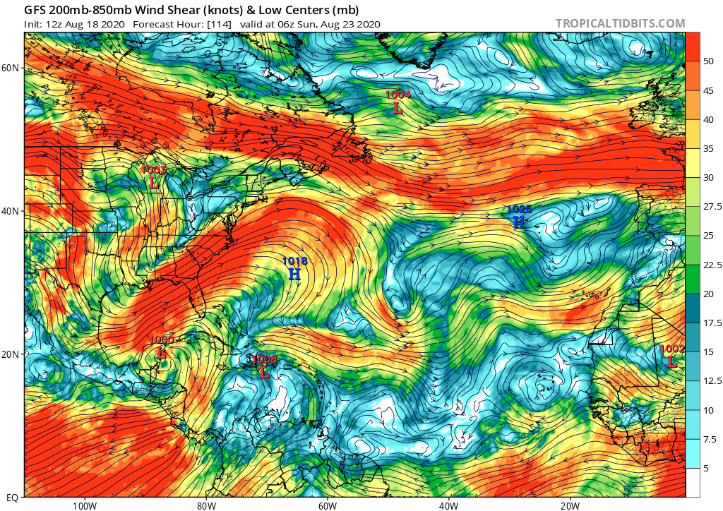
The GFS again keeps this weak at least out through 5 days so far.. For as much bashing the model gets, it has been doing quite well not only in the EPAC but with its genesis forecasts for Cape Verde waves so far. Remember for Isaias, it was more bearish on development off Africa while the EPS and Euro as well as UKMET were really bullish. Yes that wave finally developed but not as fast as many thought. I would not be placing much weight on the models like the ICON, CMC, and NAVGEM. Also if 97L develops, there could be way too much shear in the Bahamas should 98l head that way.
0 likes
-
CyclonicFury

- Category 5
- Posts: 2038
- Age: 27
- Joined: Sun Jul 02, 2017 12:32 pm
- Location: NC
- Contact:
Re: ATL: INVEST 98L - Models
gatorcane wrote:The GFS again keeps this weak at least out through 5 days so far.. For as much bashing the model gets, it has been doing quite well not only in the EPAC but with its genesis forecasts for Cape Verde waves so far. Remember for Isaias, it was more bearish on development off Africa while the EPS and Euro as well as UKMET were really bullish. Yes that wave finally developed but not as fast as many thought. I would not be placing much weight on the models like the ICON, CMC, and NAVGEM. Also if 97L develops, there could be way too much shear in the Bahamas should 98l head that way.
https://i.postimg.cc/wMhFryC5/gfs-shear-atl-20.png
Not sure why you put a lot of stock in the GFS when it keeps pushing the MJO back into Phase 8. For Isaias, it did not show development at all until the wave exited Africa, and for a while it developed it into a strong hurricane way too fast. GFS was not the only model to predict Genevieve, the ECMWF did as well.
6 likes
NCSU B.S. in Meteorology Class of 2021. Tropical weather blogger at http://www.cyclonicfury.com. My forecasts and thoughts are NOT official, for official forecasts please consult the National Hurricane Center.
-
toad strangler

- S2K Supporter
- Posts: 4546
- Joined: Sun Jul 28, 2013 3:09 pm
- Location: Earth
- Contact:
Re: ATL: INVEST 98L - Models
12Z destroys 98L over Greater Antilles
0 likes
My Weather Station
https://www.wunderground.com/dashboard/pws/KFLPORTS603
https://www.wunderground.com/dashboard/pws/KFLPORTS603
-
Blown Away
- S2K Supporter
- Posts: 10253
- Joined: Wed May 26, 2004 6:17 am
Re: ATL: INVEST 98L - Models

12z GFS... When GFS latches on to an idea it doesn't let go easy... Keeps 98L weak and gets tangled in Hispaniola... Euro has had some big flip/flopping whereas GFS has stuck with the same solution for @2 days... The moisture envelope does appear to be slightly N of the 06z and HP slightly weaker...
0 likes
Hurricane Eye Experience: David 79, Irene 99, Frances 04, Jeanne 04, Wilma 05… Hurricane Brush Experience: Andrew 92, Erin 95, Floyd 99, Matthew 16, Irma 17, Ian 22, Nicole 22…
-
TheStormExpert
Re: ATL: INVEST 98L - Models
The same model that kept insisting Dorian would slam into SE Florida. But it may actually be the most realistic considering the time of year and the fact that models like the GFS are completely lost!
0 likes
-
AutoPenalti
- Category 5
- Posts: 4091
- Age: 29
- Joined: Mon Aug 17, 2015 4:16 pm
- Location: Ft. Lauderdale, Florida
Re: ATL: INVEST 98L - Models
GFS solution, as crazy as it sounds, seems feasible at the moment.
However, this doesn't seem to be the reason for the amount of shear that will be developing once 98L crosses this area.
gatorcane wrote:The GFS again keeps this weak at least out through 5 days so far.. For as much bashing the model gets, it has been doing quite well not only in the EPAC but with its genesis forecasts for Cape Verde waves so far. Remember for Isaias, it was more bearish on development off Africa while the EPS and Euro as well as UKMET were really bullish. Yes that wave finally developed but not as fast as many thought. I would not be placing much weight on the models like the ICON, CMC, and NAVGEM. Also if 97L develops, there could be way too much shear in the Bahamas should 98l head that way.
https://i.postimg.cc/wMhFryC5/gfs-shear-atl-20.png
However, this doesn't seem to be the reason for the amount of shear that will be developing once 98L crosses this area.
Last edited by AutoPenalti on Tue Aug 18, 2020 11:18 am, edited 1 time in total.
0 likes
The posts in this forum are NOT official forecasts and should not be used as such. They are just the opinion of the poster and may or may not be backed by sound meteorological data. They are NOT endorsed by any professional institution or STORM2K. For official information, please refer to products from the NHC and NWS.
Model Runs Cheat Sheet:
GFS (5:30 AM/PM, 11:30 AM/PM)
HWRF, GFDL, UKMET, NAVGEM (6:30-8:00 AM/PM, 12:30-2:00 AM/PM)
ECMWF (1:45 AM/PM)
TCVN is a weighted averaged
-
WeatherEmperor
- S2K Supporter
- Posts: 4806
- Age: 42
- Joined: Thu Sep 04, 2003 2:54 pm
- Location: South Florida
Re: ATL: INVEST 98L - Models
UKMET is the blue line. The text output shows "weak" but it has 98L moving WNW towards South Florida. I dont know what intensity it has though

Sent from my iPhone using Tapatalk
Sent from my iPhone using Tapatalk
2 likes
-
TheStormExpert
Re: ATL: INVEST 98L - Models
gatorcane wrote:The GFS again keeps this weak at least out through 5 days so far.. For as much bashing the model gets, it has been doing quite well not only in the EPAC but with its genesis forecasts for Cape Verde waves so far. Remember for Isaias, it was more bearish on development off Africa while the EPS and Euro as well as UKMET were really bullish. Yes that wave finally developed but not as fast as many thought. I would not be placing much weight on the models like the ICON, CMC, and NAVGEM. Also if 97L develops, there could be way too much shear in the Bahamas should 98l head that way.
https://i.postimg.cc/wMhFryC5/gfs-shear-atl-20.png
If it goes over the Greater Antilles it'll be a much weaker system. If it goes north and into The Bahamas then it'll be a much stronger system.
0 likes
Who is online
Users browsing this forum: No registered users and 55 guests